
Mission Analysis and Navigation Design for Uranus Atmospheric Flight
- Faculty of Aerospace Engineering, Delft University of Technology, Delft, The Netherlands (bessette@student.tudelft.nl)
We present a 6 DoF mission concept for in situ probing of Uranus’ atmosphere, consisting of two un-propelled gliders and one orbiter in continuous line of sight. We focus on analysing the gliders’ navigation and science modules. The post-processing relation between the vehicles’ estimated states and measured scientific data is investigated. In situ probing by the gliders will allow measurement of spatially variable properties of Uranus’ atmosphere over a flight duration of up to 25 Earth days, as compared to a few hours for a descent probe.
I. Introduction
No spacecraft has ever been to the Ice Giants to perform in situ measurements. The 2030s will offer this possibility, thanks to an alignment of planets allowing gravity assists by Venus and Jupiter, to reach Uranus with limited fuel consumption. This, combined with the illumination of Uranus’ unobserved Northern hemisphere allows for unique science opportunities. In situ knowledge of an Ice Giant’s atmosphere can provide information on the formation of the planet and on that of the Solar System. In particular, it could provide insight into why several models predict these planets’ formation to have taken place much closer to the Sun than where they presently are [1]. The following research question will drive the study: How can knowledge about Uranus’ current atmosphere help us understand the formation of the Ice Giants, and in a broader sense, that of the Solar System?
This study investigates the feasibility of a mission with two gliders exploring Uranus’ atmosphere. The focus is on the systems’ navigation filter and on the post-processing relation between their estimated states and in situ scientific data. All chosen navigation sensors and scientific instruments related to navigation will be modelled in Matlab/SIMULINK and coupled with a 6 DoF flight dynamics model to estimate the gliders’ states with sufficient accuracy. Scientific instruments are used as navigation sensors to tackle the ineffective use of optical sensors due to Uranus’ high opacity atmosphere. The navigation module shall thus provide accurate information on the gliders’ estimated states, and on any other knowledge needed to interpret the scientific data.
II. Proposed Method
The proposed mission architecture consists of two gliders flying in a straight symmetrical flight with tailwind, accompanied by a spacecraft orbiting Uranus. The science objectives can be divided into Tier 1, Tier 2A, and Tier 2B, in order of importance [2]. To fulfil them, Uranus’ troposphere, which extends from 0.1 bar (≈ 50 km deep) to 100 bar (-375 km deep) [3], is targeted. Two target latitudes are selected: the equatorial domain at λ = 17.5°N and the polar domain at λ = 89°N. The gliders will fly at positive longitudes to explore both day and night sides of the Northern hemisphere.
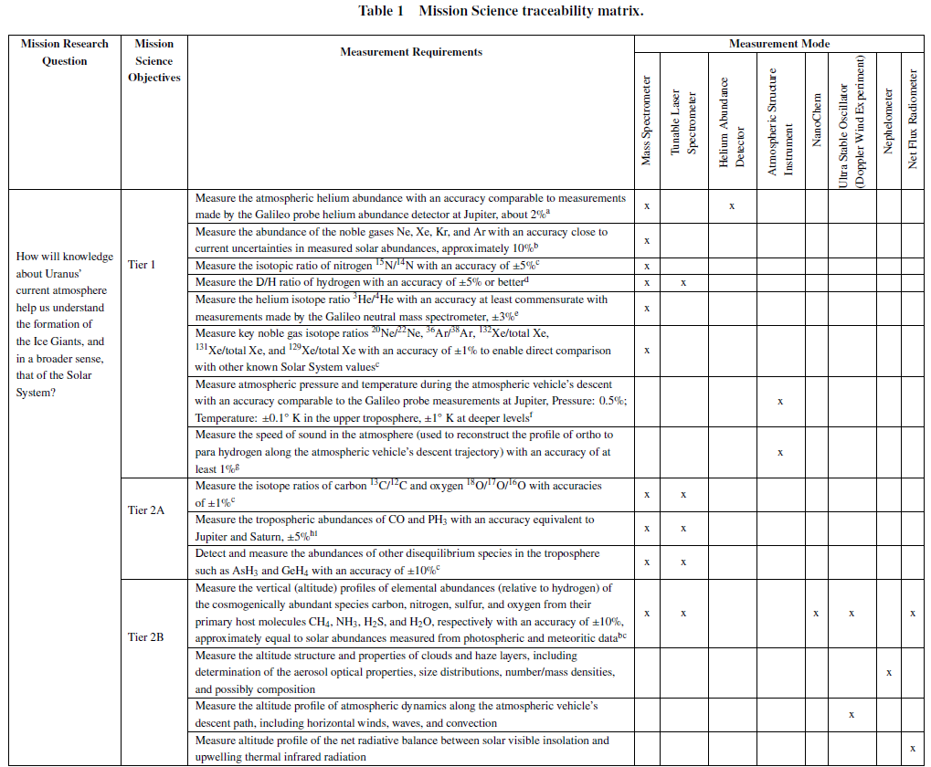
The mission’s scientific payload is inspired by [2] with the addition of a NanoChem instrument [4], for a total payload mass of about 25 kg. A science traceability matrix (Table 1) shows how each instrument contributes towards the research question.
The reference glider possesses ailerons, elevators, and a rudder. The aerodynamic coefficients were generated with Tornado [5] for minimum and maximum Mach numbers: M = 0.008 and M = 0.630. When flying at different angles of attack, the gliders' flight time can range from 2.36 Earth days at α = -6.5° to around 25 Earth days at α = -6°. The orbiter will perform a gravity assisted capture by Uranus and insert itself into a circular orbit, releasing each descent probe containing the gliders at the orbit’s periapsis passages, making use of Uranus’ fast rotation to reach the target latitudes and longitudes.
III. Preliminary Results
The telecommunication between the gliders and the orbiter is inspired by [6]. Respecting a maximum aspect angle of 60° w.r.t. the gliders’ zenith, a maximum range of 100,000 km, and considering a science data rate of 1,493 bps, around 18 min will be needed per glider to uplink its data to the orbiter, and 60 h for the orbiter to transmit that data to Earth. For maximum range, a minimum glide angle of 0.19° is found as well as a corresponding maximum arc distance of darc = 112,256.47 km. By having the gliders fly at respective latitudes of 89°N and 17.5°N, an orbiter at a minimum altitude of 26,487.5 km can continuously be in the gliders’ telecommunication cones.
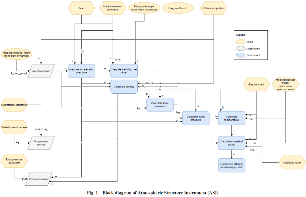
The selected navigation module’s sensors are: an Inertial Measurement Unit (IMU), a Flush Air Data Sensor (FADS), and an Ultra High Frequency (UHF) transceiver. We model and implement an additional sensor, namely the Atmospheric Structure Instrument (ASI), as part of the mission’s scientific instrument suite (Figure 1). It contains an accelerometer, a temperature sensor, and an ambient pressure sensor. Any instrument errors are neglected for now, but will be included in the final version of this study. For now, the drag coefficient CD is assumed to be determined correctly before flight, but will be changed when errors are added to obtain a more realistic flight value.
In the final version of this study, the UHF will be modelled and related to the software, in order to conduct the Doppler wind experiment and navigation radio ranging. The post-processing relation between the gliders’ estimated states and measured data will be presented, to yield accurate state estimations for trajectory tracking.
References
[1] Morbidelli, A., et al., “Dynamics of the Giant Planets of the Solar System in the Gaseous Protoplanetary Disk and Their Relationship to the Current Orbital Architecture,” AJ, Vol. 134, No. 5, 2007, pp. 1790–1798. https://doi.org/10.1086/521705.
[2] Atkinson, D. H., et al., “Reference Model Payload for Ice Giant Entry Probe Missions,” Space Sci. Rev., Vol. 216, No. 8, 2020, 120. https://doi.org/10.1007/s11214-020-00738-y.
[3] Lunine, J. I., “The atmospheres of Uranus and Neptune.” ARA&A, Vol. 31, 1993, pp. 217–263. https://doi.org/10.1146/annurev.aa.31.090193.001245.
[4] Li, J., et al., “Carbon Nanotube Sensors for Gas and Organic Vapor Detection,” Nano Letters, Vol. 3, No. 7, 2003, p. 929–933. https://doi.org/10.1021/nl034220x.
[5] Melin, T., “User’s Guide and Reference Manual: Tornado 1.0,”, 2001.
[6] Hofstadter, M., et al., “NASA Ice Giants Pre-Decadal Study Final Report,” Tech. rep., Jet Propulsion Laboratory California Institute of Technology, Pasadena, California, Jun. 2017.
How to cite: Bessette, E., Stam, D., and Mooij, E.: Mission Analysis and Navigation Design for Uranus Atmospheric Flight, European Planetary Science Congress 2021, online, 13–24 Sep 2021, EPSC2021-209, https://doi.org/10.5194/epsc2021-209, 2021.