
Spectral variability of brigth regions whitin Kuiper quadrangle: spectral indication for integrated geostratigraphic maps
 1,1,1,1,2,1,1
- 1IAPS-INAF, Rome, Italy (cristian.carli@inaf.it)
- 2Geoscience Department, University of Padova, Padua, Italy
- 3DISTAR, Università degli Studi di Napoli Federico II, Naples, Italy
- 4DST, Università degli Studi di Napoli ‘Parthenope’, Naples, Italy
Introduction: Kuiper quadrangle (H06) is located at the equatorial zone of Mercury and encompasses the area between longitudes 288°E – 360°E and latitudes 22.5°N – 22.5°S. A detailed geological map (1:3M scale) for this quadrangle based on the MESSENGER/MDIS derived maps, was produced [1] and an integrated geo-stratigraphic map is being prepared [2], [3].
The geological map showed that the quadrangle is characterized by a prevalence of crater materials, which were distinguished into three classes based on their degradation degree [4]. The different crater’s density permits to discriminate different plain units. Several bright regions are evidenced within H06, and in particular, different craters highlight both the presence of hollows and pyroclastic material [e.g., 5]. Some craters display very bright ejecta and Kuiper crater shows extended bright rays.
Data and Method: Multi-spectral maps of Kuiper quadrangle were produced using MDIS (Mercury Dual Imaging System) WAC data. Since H06 is located at low latitudes, the data coverage with high spatial resolution is lower than the northern quadrangles [e.g. 6-7]. This suggested to approach the analysis in multiple-stage passages. This has been done to investigate the H06 region with the best detail from a spectral point of view but also to compare the outcomes of the analysis performed at different resolution scales where it was possible. We produced an homogeneous 8 color global mosaic at 1600 m/px scale (average scale taking into account the average resolution within the quadrangle) and one at 665 m/pixel pushing the resolution, but excluding from the coverage the southern areas. Moreover, we used partial quadrangle coverage at 385 m/px and 246 m/px to exploit the presence of higher resolution color images.
Preliminary results: We will show spectral variations considering specific indices and color combinations, discussing the possibility to define spectral units among these bright regions, which could be integrated with the morpho-stratigraphic mapping. Locally, we will investigate the spectral variability for specific surface features, such as bright regions, fresh craters, hollows, pyroclastic deposits.
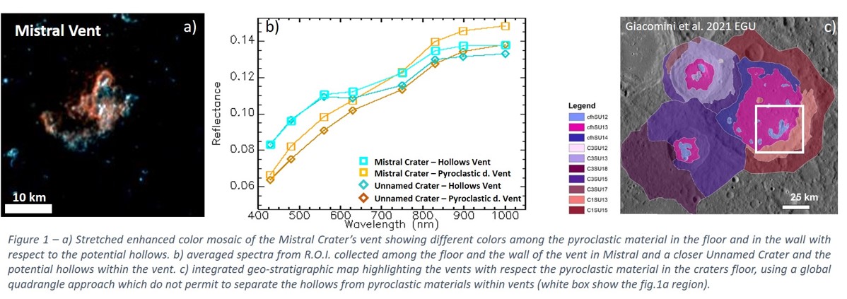
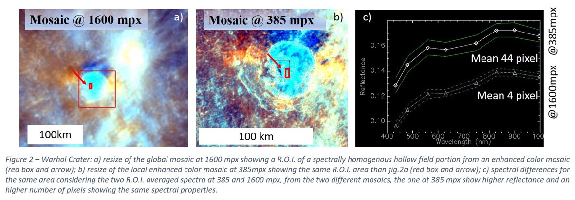
This analysis allows us to infer some indications on material composition and discriminate among the bright features, which seems to have an higher spectral variability (e.g. reflectance and slope variation) and an evidence of a possible absorption around 650 nm (e.g. Fig.1), already evidence in the literature [e.g. 8]. The definition of this compositional information permits also to produce a more detailed geological map of those regions in H06 showing correlations between morpho-stratigraphic and spectral units [2]. We also studied the variability with the spatial scale of spectral properties of different regions to investigate to the variation of this data varying the resolution on the surface. In Fig.2, for example, we show how the details change in the hollows field in the Warhol crater with the spectral differences from the same area for the two cases. Moreover the hollows spectral properties are characterizing an higher number of pixels where the spatial resolution is better. We will show some examples of such integrated maps.
Conclusions: In particular, at this preliminary stage, we can show that:
- Bright regions have, in general, a reflectance variation ranging from 0.1 to 0.12 at 750 nm, but they show different spectral slopes and a larger reflectance variation towards the UV;
- In general hollows and some small bright spot are bluer than pyroclastic materials and rays; furthermore, wherever hollows can be clearly identified by morphology they tend to show an indication of an absorption around 650 nm and an inflation towards IR;
- When a higher spectral resolution can be used for the same R.O.I., we clearly see higher definition of spectral variability and higher number of pixel showing diagnostic features (e.g. hollow spectra).
This preliminary analysis highlights that both higher spectral and spatial resolutions are needed in order to obtain new information about the landforms’ origin. In light of these evidences, it appears that the high resolution of the instruments of BepiColombo mission, like SIMBIO-SYS, can significantly contribute to answer several questions raised during the geological mapping and analysis of the Kuiper quadrangle.
Acknowledgments: We gratefully acknowledge funding from the Italian Space Agency (ASI) under ASI-INAF agreement 2017-47-H.0. MM, CC, FZ, FA were also supported by European Union’s Horizon 2020 research grant agreement No 776276- PLANMAP. MM, CC, FA, GL, VG were also supported by Europlanet RI20-24 research grant agreement No. 871149-GMAP.
References: [1] Giacomini et al., 2018. EPSC abstract 721-1. [2] Giacomini et al., 2021. LPSC abstract, 15052. [3] Carli et al., 2020. EPSC abstract, 367. [4] Galluzzi et al., 2016. J. Maps, 12, 226–238. [5] Pajola et al., 2020. PSS, 195, . [6] Bott et al. 2019. JGR, 124, 2326-2346. [7] Zambon et al. 2019. EGU, 7796. [8] Lucchetti et al. 2018. JGR, 123, 2365–2379.
How to cite: Carli, C., Giacomini, L., Zambon, F., Galluzzi, V., Ferrari, S., Massironi, M., Altieri, F., Ferranti, L., Palumbo, P., and Capaccioni, F.: Spectral variability of brigth regions whitin Kuiper quadrangle: spectral indication for integrated geostratigraphic maps, Europlanet Science Congress 2021, online, 13–24 Sep 2021, EPSC2021-238, https://doi.org/10.5194/epsc2021-238, 2021.