Evidence for scalloped terrains on 67P
- 1Aix Marseille Univ, CNRS, CNES, LAM, Marseille, France
- 2GEOPS, Univ. Paris-Sud, CNRS, Université Paris-Saclay, 91405 Orsay, France
Introduction
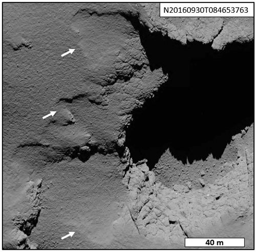
The Rosetta mission provided detailed data of the surface of the nucleus of comet 67P/Churyumov-Gerasimenko. The analysis of these data, and especially the images of the Narrow Angle Camera (NAC) from the Optical Spectroscopic and Infrared Remote Imaging System (OSIRIS instrument; Keller et al., 2007), revealed the morphological diversity of the nucleus surface (El-Maarry et al., 2019). Among these morphologies, depressions have been observed in several regions (Fig.1).

Figure 1: Example of studied depression located on Ma'at region (NAC image, 1 m/pixel). The white arrows indicate the depressions
The origin of these structures remains unclear and several hypotheses have been proposed: (1) the depressions could be indicative of scarp retreat (Vincent et al., 2016; El-Maary et al., 2017), (2) they mark the location of future cliff collapses (Pajola et al., 2016d), and (3) they are seasonal structures shaped by the changes induced by perihelion approach (Groussin et al., 2015). In a previous study, we studied two of these depressions, located in the Ash region, by a comparative morphometrical analysis (Bouquety et al., 2021). We observed that the two depressions grew by several meters during the last perihelion passage, and that this growth is not necessarily linked with cliff collapses. Thus, in that case, the sublimation of ices certainly played a key role in shaping these depressions.
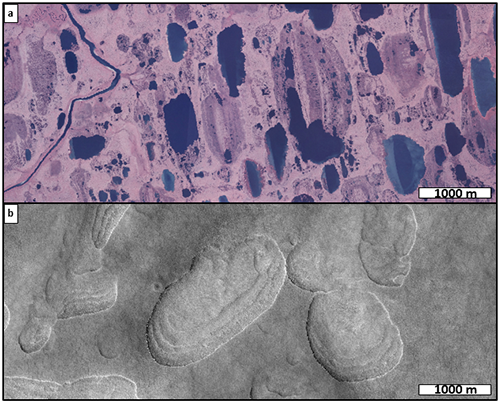
On Earth and Mars, there are similar depressions with the same shape and geometry that are controlled by thaw processes. These depressions are called thermokarstic lakes on Earth and scallops depressions on Mars (Fig.2). On both planets, these periglacial structures result from the degradation of an ice rich permafrost (Costard and Kargel, 1995; Morgenstern et al., 2007; Séjourné et al., 2011).

Figure 2: Example of thaw depressions. (a) Thermokarstic lakes in Alaska on Earth (Digital Orthophoto Quadrangle DOQ, 5 m/pixel). (b) Scalloped terrain in Utopia planitia on Mars (HiRISE image, 50 cm/pixel).
Due to their processes and morphological similarities, we decided to compare the depressions observed on 67P’s surface with thermokarstic lakes on Earth and scallops depressions on Mars to constrain their origin.
Data and Method
We used the same method as in Bouquety et al., (2021). This comparative morphometrical analysis (CMA) allows to study surface features via a morphological and geometrical approach, with a great level of detail, in order to build an interplanetary database which can be used for comparison.
In order to perform the comparison, a list of parameters and criteria that can be applied on Earth, Mars and 67P. For each depression we measured 10 parameters: the length, width, area, perimeter, depth, slope (max, min, mean), elongation and the circularity index (Ulrich et al., 2010; Séjourné et al., 2011; Morgenstern et al., 2011; Niu et al., 2014). Based on different dataset and their associated DTM (Earth: DOQ/3DEP; Mars: HiRISE/HiRISE DTM; 67P: NAC/SPC method (Jorda et al.,2016)), we measured a total of 432 depressions, namely 200 on Mars (Utopia planitia), 101 on Earth (Arctic coastal plain) and 131 on the whole 67P’s surface.

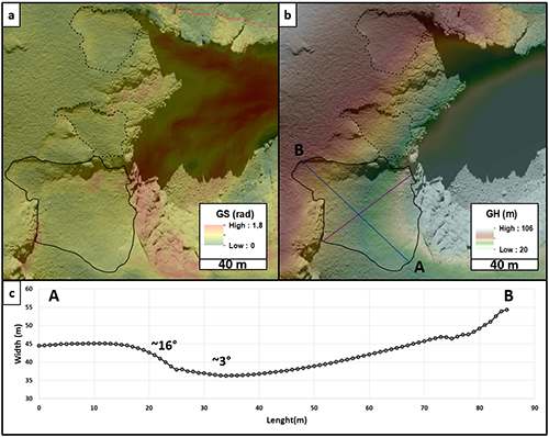
Figure 3: Example of measurement. Gravitational: (a) slopes and (b) height draped on NAC images. (c) Topographic profile extracted from GH.
Results and interpretations
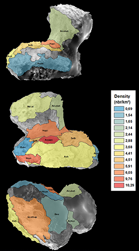
The depressions are exclusively located in terrains covered by fine deposit particules (FDP), and seems to be present in all topographical contexts. The highest depression densities are located on the body, where FPD covers the majority of the region (Thomas et al., (2018); Fig.4).

Figure 4: Density map of the measured depression according to the region.
The analysis also revealed that the set of measured parameters is consistent with the references known in the literature. Remarkably, all the measured parameters on 67P depressions are included in the range that characterized scallops terrains on Mars and thermokarstic lakes on Earth (Ulrich et al., 2010; Séjourné et al., 2011; Morgenstern et al., 2011; Niu et al., 2014). Moreover, depressions from 67P follow the same area/perimeter trend as scallops on Mars and thermokarstic lakes on Earth (Fig.5). Finally, more than 90% of 67P depressions topographic profiles show a slope asymmetry (Fig.1c). This slope asymmetry has been observed on thermokarstic lakes on Earth and scallops on Mars and interpreted to be characteristic of depressions shaped by the obliquity-driven insolation (Plescia, 2003; Morgenstern et al., 2007; Séjournée et al., 2011).
Figure 5: Area versus perimeter for all the measured depressions on 67P, Mars, and Earth.
These three results indicate that: (1) the depressions from 67P follow the same growth ratio than the scallops and the thermokarstic lakes while keeping their characteristic circularity, and (2) the sublimation induced by perihelion passages is the main erosion process that shaped these depressions on the comet (Bouquety et al., 2021). Our morphometrical analysis allowed to conclude that depressions on 67P are analogues to scalloped terrain on Mars and thermokarstic lakes on Earth.
References
Bouquety, A., Jorda, L., Groussin, O., et al. 2021, Astronomy & Astrophysics
Costard, F., Kargel, J., 1995, Icarus 114, 93-112
El-Maarry, M. R., Groussin, O., Thomas, N., et al. 2017, Science, 355, 1392
El-Maarry, M. R., Groussin, O., Keller, H. U., et al. 2019, Space Science Reviews, 215
Groussin, O., Sierks, H., Barbieri, C., et al. 2015b, Astronomy & Astrophysics, 583, A36
Jorda, L., Gaskell, R., Capanna, C., et al. 2016, Icarus, 277, 257
Keller, H. U., Barbieri, C., Lamy, P., et al. 2007, Space Science Reviews, 128, 433
Morgenstern, A., Hauber, E., Reiss, D., et al. 2007, J. Geophys. Res. 112, E0600.
Morgenstern, A., Grosse, G., Günther, F., et al. 2011, The cryosphere, 5, 4
Niu, F., Luo, J., Lin, Z., et al. 2014, Arctic, Antarctic, and Alpine Research, 46:4, 963-974
Pajola, M., Oklay, N., Forgia, F. L., et al. 2016, Astronomy & Astrophysics, 592, A69
Plescia, J.B., 2003. 34th Lunar Planetary Science, abstract# 1478.
Séjourné, A., Costard, F., Gargani, J., et al. 2011, Planetary and Space Science 59, 412-422
Thomas, N., El-Maarry, M. R., Theologou, P., et al. 2018 Planetary and Space Science 164, 19-36
Ulrich, M., Morgenstern,A., Gunther, F., et al.2010. J. Geophys. Res. 115(E10), E10009
Vincent, J.-B., Oklay, N., Pajola, M., et al. 2016, Astronomy & Astrophysics, 587, A14
How to cite: Bouquety, A., Groussin, O., Jorda, L., Séjourné, A., Costard, F., and Bouley, S.: Evidence for scalloped terrains on 67P, Europlanet Science Congress 2021, online, 13–24 Sep 2021, EPSC2021-25, https://doi.org/10.5194/epsc2021-25, 2021.

