
Photometry of Europa: estimation of albedo map and empirical global photometric model
 1,
1,- 1European Space Agency (ESA), European Space Astronomy Centre (ESAC), Camino Bajo del Castillo s/n, 28692 Villanueva de la Cañada, Madrid, Spain
- 2GEOPS, Université Paris-Sud, CNRS, Université Paris-Saclay, Rue du Belvédère, Bât. 504, 91405 Orsay, France.
Abstract
We are proposing a new approach for estimating the effects of photometry on Europa’s remote sensing data by estimating at the same time an albedo map as well as unique empirical photometric model for the surface from past observations, for engineering and mapping purposes.
Introduction
With its young icy surface covering a global water ocean, Europa is a strong contender in the search for habitability in our Solar System. Photometry plays a key role in deriving remote sensing science products. As such, photometric correction is often the first step of any remote sensing analysis such as mapping or spectroscopy. In itself, photometry is closely linked to the surface microtexture and can help us better understand the physical state of a surface. In this study, we are proposing to approach the issue of photometric correction by estimation an albedo map as well as a unique global photometric model.
Dataset
We are working from the dataset that we compiled for our regional photometric study [1] comprised of images from the Voyager probes dataset taken with the Imaging Science System (ISS) [2] and from the New Horizons spacecraft taken with the LOng Range Reconnaissance Orbiter (LORRI) [3] with a ground resolution between 10 km and 30 km at the subspacecraft point. All Voyager images are limited to the clear filter.
The entire data processing pipeline is described in [1] and [4]. This includes corrections of metadata errors - such as spacecraft position and camera orientation – distortion and absolute calibration inconsistencies. This last point ensures that two observations of the same location and same geometries are consistent, which was not the case in the raw dataset.
Method
- Model
We project each image of the dataset to a map with a 10º resolution both in latitude and longitude. We want to approximate the photometry of Europa as an albedo map of 10º by 10º modulated by a unique photometric model across the surface. In other words, for every point, we want to estimate the reflectance as:
r(lon, lat, e, i, g) = A(lon, lat) * f(e,i,g)
where:
- r is the reflectance
- lon is the local longitude
- lat is the local latitude
- e is the emission angle
- i is the incidence angle
- g is the phase angle
- A is the albedo map
- f is the global photometric model
For this study, we want to replicate our approach with several models:
- the Hapke model detailed in Hapke, 1993 [5]
- the Oren-Nayar model [6]
- a polynomial model defined as:
r = I/F = x0 + x1cos(i) + x2cos(e) + x3cos(g) + x4cos(i)cos(e) + x5cos2(i) + x6cos2(e) + x7cos2(g)
Estimation
Intuitively, we could try to estimate all the albedos and the photometric parameters at the same time. But this would be very inefficient and necessitate considerable computing power. Let's consider a global map sampled at 10° intervals. We have 36*18=648 values to estimate. If we choose the polynomial photometric model, this adds 8 parameters to estimate, which makes a total of 648+8=656 unknowns.
To have a more efficient estimation, we proceed in two steps:
- step 1: we select areas with dense coverage : the 20 locations with the densest number of pixels and the 20 areas imaged with the widest phase angle coverage. For these 40 areas, we have a unique set of 8 photometric parameters as well as an albedo value for each of them, which makes a subset of 48 unknowns.
- step2: we use the photometric results of step 1 to estimate the albedo values for the rest of the map.
We are using a Nelder-Mead simplex method to estimate the parameters. The complete algorithm is described in [7] and implemented in the fminsearch function in Matlab. It has been used in the past to estimate photometric parameters (e.g. [8]).
Preliminary results
Our preliminary results show good regional agreement with high resolution maps derived from Voyager and Galileo data [9, 10]. For example, on figure 1 showing our estimated albedo map, we can clearly see that the trailing hemisphere (east longitude 0º to 180º) is darker than the leading. Figure 2 shows the root mean square (RMS) values for each area. We see fairly low residuals across the surface.

Figure 1: Albedo map (resolution 10º) estimated for Europa
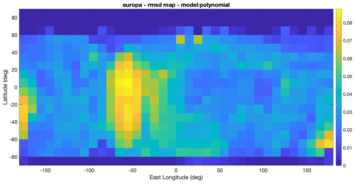
Figure 2: RMS map (in IOF units) obtained after estimation of albedo map and polynomial photometric model for Europa
Conclusion and future work
The preliminary results of this study are very encouraging in proposing a global photometric correction of Europa remote sensing data.
We plan on extending this work by using a more reliable estimation method based on previous work of estimating photometry using Bayesian statistics [1, 11, 12]. We would also like to provide a comprehensive analysis of the most common photometric models associated to this approach.
Acknowledgements
This work has been funded by the Université Paris-Saclay and the ESA research fellowship program.
References
[1] I. Belgacem et al. Regional study of Europa’s photometry, Icarus, 2019.
[2] A.Cheng , New Horizons Calibrated LORRI Jupiter Encounter v2.0, nh-j-lorri-3-jupiter-v2.0, NASA PDS, 2014.
[3] M. Showalter, VG1/VG2 Jupiter ISS processed images v1.0 VGISS_5101-5214, NASA PDS, 2013.
[4] I. Belgacem et al. Image processing for precise geometry determination, Planetary and Space Science, 2020.
[5] B. Hapke, Theory of reflectance and emittance spectroscopy. Topics in Remote Sensing, Cambridge University Press, 1993.
[6] Oren, M., Nayar, S.K. Generalization of Lambert's reflectance model, in: SIGGRAPH94, ACM Press, 1994.
[7] Lagarias et al., Convergence properties of the Nelder-Mead simplex method in low dimensions, SIAM Journal on Optimization 9, 1998.
[8] Masoumzadeh et al., Photometric analysis of asteroid (21) lutetia from rosetta-OSIRIS images. Icarus, 2015.
[9] U.S. Geological Survey, Europa Voyager - Galileo SSI Global Mosaic 500m v2, 2010.
[10] Kersten et al., Controlled global
564 ganymede mosaic from voyager and galileo images, under review at Planetary and Space Science
[11] J. Fernando, F. Schmidt, and S. Douté, Martian Surface Microtexture from Orbital CRISM Multi-Angular Observations: A New Perspective for the Characterization of the Geological Processes, Planetary and Space Science, 2016.
[12] F. Schmidt and S. Bourguignon, Efficiency of BRDF sampling and bias on the average photometric behavior Icarus, 2019.
How to cite: Belgacem, I., Schmidt, F., and Le Contellec, A.: Photometry of Europa: estimation of albedo map and empirical global photometric model, European Planetary Science Congress 2021, online, 13–24 Sep 2021, EPSC2021-276, https://doi.org/10.5194/epsc2021-276, 2021.