
 1,1,2
1,1,2- 1Open University, Milton Keynes, United Kingdom (melissa.mirino@open.ac.uk)
- 2Natural History Museum, London, United Kingdom
Introduction: Inverted channel belts have been recognized on Mars [1,2]. A channel belt represents an extensive fluvial package of sediments which usually formed from lateral migration and aggradation of a river over time [3]. An inverted channel belt is created because the sediment package developed an inversion of relief as some sections were infilled by, or formed from, a more resistant material than the neighboring terrains. The surrounding terrains, less resistant to the erosion were removed, leaving the more resistant sediments upstanding [3] and often organized into characteristic sinuous ridges. This process implies that the fluvial system that deposited the material associated with the channel belt structure must have been active and stable for a long time (about 105-107 years [1]), and then a major change occurred, moving from a period of deposition to a period of erosion. The discovery of these features on Mars could have a major role for the dry-cold versus warm-wet climate debate [4]. Here, we present results from a mapping study in support of an inverted channel belt system developed within the degraded and partially buried Arago crater,in south-east Arabia Terra.
Methodology: HRSC-MOLA DEM [5] and CTX mosaic [6,7] data were ingested into ArcGIS software to study the general context of the study area, and to assist analysis of stratigraphy. A digital morphostratigraphic map (scale 1:10,000) was constructed using the available HiRISE [8] image and represents our interpretation of the area. Units are divided into three main groups:(i) The ‘Ridge formation‘ (units with strong correlation to the main ridges and likely represent fluvially-deposited material), (ii) ‘Basal units, (terrains stratigraphically below the inverted systems, or unrelated to them), (iii) ‘Miscellaneous units’ (heterogeneous materials, erosional remnants). The focus of the mapping was to determine the relationships between the sinuous ridge segments and the proximal surrounding terrains.
Observations: Arago crater is in Middle Noachian [9] terrains, and is bordered by valley networks [10] at north and south, suggesting that the area was influenced by fluvial processes. Water probably filled Arago crater and the surrounding topographic lows, evolving into temporary paleo-lakes or basins. The studied system is found at the south-west of Arago crater and here we refer to it informally as Arago Dorsum. Arago Dorsum is a continuous, branched, inverted network. Each branch of the system presents a variation in cross section style, expressing a different erosional stage[11]. The branches present smooth or cratered upper surfaces, and the longest segments are connected to smaller, secondary ridges. The Arago Dorsum ridges are upstanding and set within a low-reliefelevated material, demonstrating that they are resistant to erosion. The ridges are both laterally and vertically separated, organised in a multilevel structure.
Results: In the Ridge Formation sequence (Fig. 1), the main mapped ridges units (Urf 1-2, Srf 1-2, Lrf 1-2-3) are set at different stratigraphical levels and distributed within both Marginal units (Mrf 1-2) and the lower Transitional units (Trf 1-2-3), which correspond to ~65 m of vertical deposits (Fig. 2). Mapping allowed the recognition of other fine-scale features including: (i) more resistant thin layers visible at the flanks of the main ridges, or distributed in the Marginal units, (ii) the presence of smaller and secondary sinuous ridges which connect and disconnect at different stratigraphical levels, (iii) the presence of polygonal networks, possibly connected with secondary groundwater infilling, (iv) boulders and mass wasting falling from the ridges.
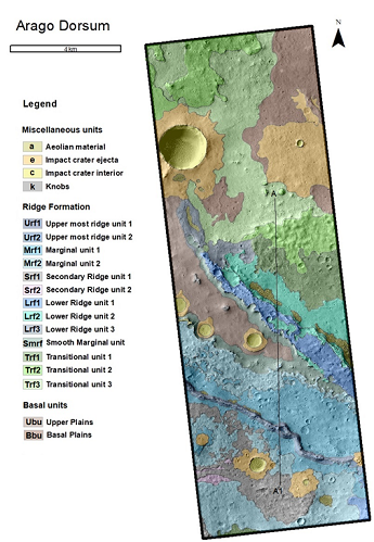
Figure 1: Gemorphic map of the “Arago Dorsum” system. The track A-A1 is presented in Fig. 2.
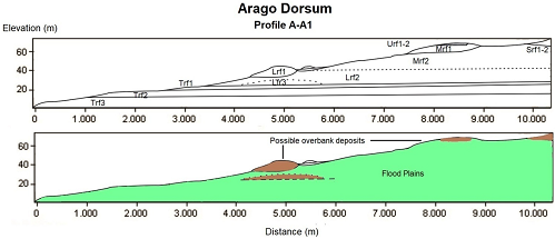
Figure 2: Morphostratigraphic profiles(vertical exaggeration x 20) presenting the main mapped units (indicated with labels on the top) and the interpretation (bottom). The cross-section A-A1 track is indicated in Fig. 1.
Interpretation: Based on the recognised fine-scale features, ridge morphologies, distribution and relationship of the mapped units, we interpret Arago Dorsum to represent the expression of an aggrading fluvial system, now preserved as an inverted channel belt. Specifically, the alternation of more resistant (ridges and layers) and the less resistant (Marginal-Transitional) units is in line with a flood plain sequence with preserved overbank deposits and discrete or stacked channel bodies. The three main ridges identified in the mapping area represent three periods of deposition. As other ridges have been recognised at CTX observation scale, the sequences reported here include only part of the Arago Dorsum stratigraphy, which may be even more complex, and probably even more long lived.
Conclusions: We interpret the Arago ridge system to be fluvial in origin, preserved in positive relief and now modified by differential erosion. Our observations and mapping reveal the inverted channel candidate to be the sedimentary deposits of an extensive aggradational fluvial channel-belt system, probably active in the Mid-Noachian. Valley networks inflowing Arago crater possibly supplied the channel-belt. There is a succession with at least 65 m vertical thickness of fluvial sediments here. Aram Dorsum, in western Arabia Terra (over 2000 km distance and over 1500 m elevation difference from Arago) presents very similar characteristics, including (i) age, (ii) morphology, (iii) vertical thicknesses of sediments, and (iv) the presence of polygonal networks developed in the units associated with the ridge development. These similarities suggest that similar thicknesses, volumes, and secondary processes (burial, erosion, groundwater alteration) of mid-Noachian fluvial sediments may be extensive and common in Arabia Terra. The presence of two (probably more) inverted channel belts, dated to the Mid-Noachian provide supports a past climate with widespread precipitation across Arabia Terra during this period.
References:[1] Balme et al.,(2020), JGR Planets,https://doi.org/10.1029/2019JE006244. [2] Liu et al.,(2020), Earth and Planetary Science Letters, https://doi.org/10.1016/j.epsl.2021.116854. [3] Hayden et al.,(2019), Icarus, https://doi.org/10.1016/j.icarus.2019.04.019.[4] Wordsworth et al.,(2016), Annual Review of Earth and Planetary Sciences, 10.1146/annurev-earth-060115-01235.[5] Fergason et al.,(2018), Astrogeology PDS Annex, U.S. Geological Survey. http://bit.ly/HRSC_MOLA_Blend_v0. [6] Dickson et al.,(2018), LPSC, 2480. [7] Malin et al., (2007), JGR Planets10.1029/2006JE002808. [8] McEwen et al.,(2007), JGR Planets, https://doi.org/10.1029/2005JE002605. [9] Tanaka et al.,(2014), GeologicMap of Mars: USGS Scientific Investigations SeriesMap 3292, scale 1:20,000,000, pamphlet 43 p. [10] Hynek et al.,(2010), Journal of Geophysical Research, https://doi.org/10.1029/2009JE003548. [11] Mirino et al.,(2020), LPSC, 1500. [10] Mirino et al.,(2020), LPSC 1492.
How to cite: Mirino, M., Balme, M., Fawdon, P., and Grindrod, P.: Evidence for a channel belt development within the Arago crater on Mars., Europlanet Science Congress 2021, online, 13–24 Sep 2021, EPSC2021-311, https://doi.org/10.5194/epsc2021-311, 2021.