
Geological Mapping, Topography and Stratigraphy of Thrace and Thera Macula, Europa
 1,2,1,2,1,2
- 1International Research School of Planetary Sciences, Pescara, Italy (gianluca.chiarolanza@unich.it)
- 2Dipartimento di Ingegneria e Geologia, Università G. d'Annunzio, Chieti, Italy
Introduction: Chaotic terrains on the icy moon Europa are among the youngest surface features within the satellite’s visible geological history [1]. These regions appear as highly disrupted surfaces formed by irregular groups of isolated plates surrounded by a lumpy matrix material [2]. They are often covered in a reddish-brown material that is interpreted to consist of hydrated sulfates [3] or sulfuric acid hydrate [4]. Current models of chaos formation include a melt-through of the surface provoked by an internal heat source (i.e. a hydrothermal plume) [5], or the mobilization of brines trapped near the surface, in response to partial melting of the outer shell induced by icy diapirs rising through the crust [6]. We investigated two chaotic terrains named Thrace Macula and Thera Macula, both located on the southern hemisphere of Europa. Among the hypotheses proposed to explain their origin are the upwarping of the surface followed by an extrusion of low-viscosity liquids [7, 8], the collapse of large-scale domes [9], or interactions between the ice and shallow subsurface water lenses [10]. Here we provide a geomorphological and stratigraphic analysis of Thrace and Thera Macula, derived from an extensive geological mapping based on the highest-resolution images of the area acquired throughout the Galileo space mission. We also provide preliminary results of a topographic analysis performed on photoclinometric DEMs obtained using Ames Stereo Pipeline [11, 12].
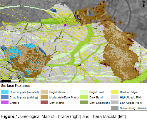
Results: The mapped area includes plains dominated by ridge complexes, bands, linear features (double ridges, troughs), craters (for less than 1%), and chaotic terrains (Fig. 1). Local displacements of band margins and double ridges suggest the occurrence of crustal movements along tectonic faults.
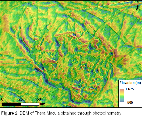
Thera Macula is characterized by a distinctive dichotomy between its northern, partly fractured icy plain, and the southern complex of low-albedo chaotic terrains. The margins of the macula, particularly to the north, appear heavily fractured and forming a complex of steep scarps faced towards the macula, with elevations ranging from -30 to -390 m (Fig. 2). The southern lobe is the only one displaying a positive relief up to 360 m in height. The dark, chaotic terrain consists for 85% of matrix material, and for 15% of large plates that show signs of displacement. On average, plates rise up to 320 m from the surrounding matrix, and some can exceed 700 m in height. Apparently, the matrix has replaced a pre-existing terrain which underwent a strong degradation process.
Thrace Macula exhibits a larger proportion of matrix material, which makes up to 98% of the macula’s surface, while the remaining 2% is composed of blocks. The latter are represented either by large plates not completely detached from the margins (only identified in the northern sector), or by small sub-kilometer, often tilted blocks found in the center of the macula. In contrast to Thera, the boundaries are not marked by steep scarps, and the matrix looks domed up above the surrounding plain. The macula’s northern and central sectors are separated by a bright, roughly linear stripe that could be an intersecting double ridge postdating the formation of the macula. The high-resolution images of the southern lobe show the presence of a higher-albedo matrix, where any pre-existing structure is no longer recognizable, and a lower-albedo matrix, where the pre-existing features are still preserved and appear mostly unaltered.
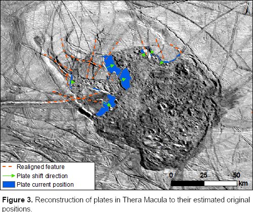
Discussion: Geological mapping has revealed that around the “non-chaotic” plains are structures intersected by linear features (troughs, double ridges, bands), that appear displaced along two opposite directions. A graphic reconstruction of the original placement of surface units has confirmed that lateral and extensional motion of the icy crust has occurred at some point during Europa’s geological history, generating linear displacements up to 7.50 km in length. Furthermore, the morphology and the orientation of the plates surrounded by the chaotic matrix in Thera Macula indicates they must have undergone shifting, rotation and tilting upon their formation. A reconstruction of the original placement of 17 plates has confirmed that 47% of them have undergone horizontal translation, moving between 0.7 and 9.2 km (Fig. 3). Also, 30% of the plates have rotated by an average of 10.6°, either clockwise or counterclockwise, whereas motion of the plates has prevalently occurred from the inward-facing scarps towards the innermost areas.
Finally, we inferred the relative age of the two maculae and the variety of geological features that comprise the surrounding plains by performing a detailed analysis of cross cutting relationships. The resulting stratigraphic column (Fig. 4) can be summarized in a four-stage sequence of events: 1) Formation of plains, including ridge complexes and smooth plains; 2) Formation of bright bands and isolated double ridges; 3) Formation of dark bands and additional linear features; 4) Formation of impact craters and chaos regions, with Thrace Macula possibly having formed earlier than Thera.

Acknowledgments: GM acknowledges support from the Italian Space Agency (2018-25-HH.0).
References: [1] Prockter L. M. et al. (1999), JGR, 104, 16531-16540. [2] Collins G. and Nimmo F. (2009), in Europa, U. Arizona Press, 259-281. [3] Dalton J. et al. (2005), Icarus, 177, 472-490. [4] Carlson R. W. et al. (2002), Icarus, 157, 456-463. [5] Greenberg R. et al. (1999), Icarus, 141, 263–286. [6] Head J. W. and Pappalardo R. T. (1999), JGR, 104, 1999. [7] Fagents S. A. (2003), JGR, 108, 2003. [8] Miyamoto H. et al. (2005), Icarus, 177, 413-424. [9] Mével L. and Mercier E. (2007), PSS, 55, 915-927. [10] Schmidt B. et al. (2011), Nature, 479, 502–505. [11] Beyer R. et al. (2018), Earth Space Sci, 5. [12] Lesage E. et al. (2021), Icarus, 361, 114373.
How to cite: Chiarolanza, G., Mitri, G., and Pondrelli, M.: Geological Mapping, Topography and Stratigraphy of Thrace and Thera Macula, Europa, Europlanet Science Congress 2021, online, 13–24 Sep 2021, EPSC2021-329, https://doi.org/10.5194/epsc2021-329, 2021.