
 1,2,1,1,
- 1Royal Observatory of Belgium, Brussels, Belgium (matthias.noeker@observatory.be)
- 2Université catholique de Louvain, Ottignies-Louvain-la-Neuve, Belgium
Introduction
The origin and composition of the Martian moon Phobos is still subject to scientific discussions that are not yet free of doubt. Visiting the inner Martian moon with a spacecraft promises to provide more insights on these questions. One future mission to visit Phobos is the Japanese Martian Moon eXplorer (MMX) mission, e.g. [1]. Such a mission, including the free-fall landing of a rover and a touch-and-go sample acquisition manoeuvre, demands a good knowledge of the (local) gravity field. Moreover, a surface gravimeter GRASS [2], was considered in the early phase of the mission on the rover to investigate the local surroundings influence on the resulting gravity. We investigate the influence of a local, artificial, high-resolution digital elevation model (DEM), superimposed on the lower-resolution Phobos shape file on the local surface gravity. For this, we have developed the Wedge-Pentahedra Method that allows analysis of the local (surface) gravity.
Methodology
For Small Solar System Bodies and natural, non-spherical satellites (hereafter: small bodies) we have, even if visited by spacecraft, only limited resolutions on the global shape files. The development of space exploratory gravimeter for small bodies GRASS [2], but also planned small body landings [1,3] and touch-and-go sample acquisition manoeuvres demand an analysis of the local terrain on the resulting (near-) surface gravity. Traditionally, the gravity of any polyhedron with (assumed) homogeneous density is computed using the polyhedral method (PM) by Werner & Scheeres [4]. This global approach makes it difficult to include a local (2D) DEM in the surrounding of the landing point and to vary the proximity material density. We developed the Wedge-Pentahedra Method (WPM) that allows to incorporate any DEM on a small body surface and to vary the density at a resolution identical to the DEM resolution.
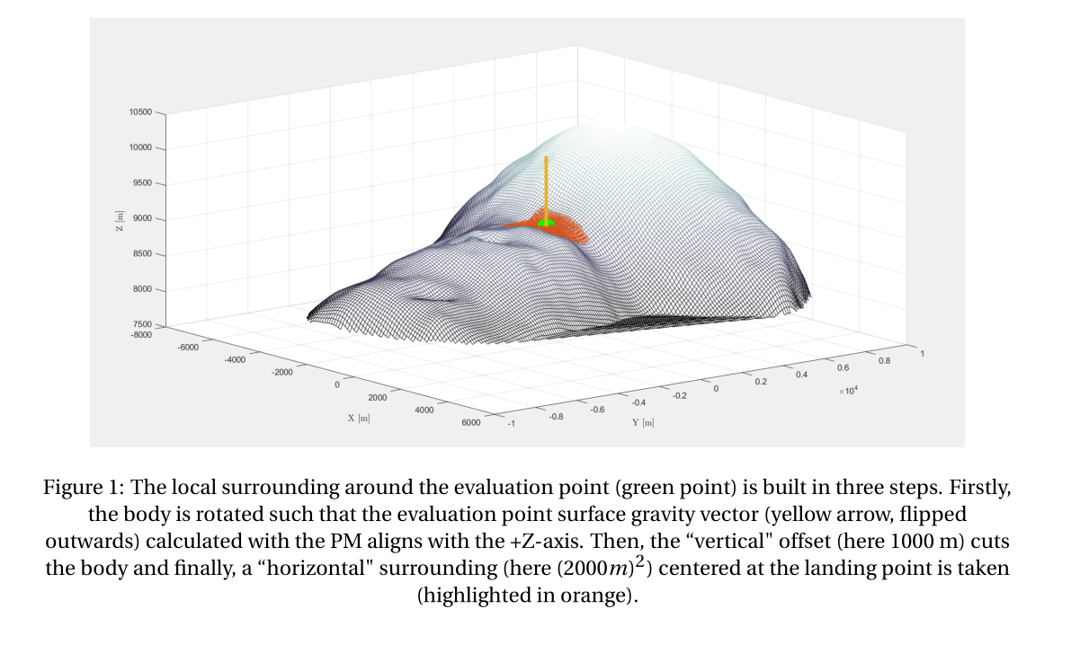
In this study, we use the global shape file of Phobos from [5] and the artificial, scalable DEM for the MMX landing site kindly provided by [6]. We localise the problem by defining a (specific or random) landing point on the Phobian surface as shown in Figure 1. On this local, lower-resolution surface, we now project the high-resolution DEM, where the original elevation value is arbitrary and therefore scaled to control the DEM amplitude.
With the DEM in place, the WPM is implemented using the high-resolution surface. Firstly, a triangulation of the DEM surface is performed. Then, from each of these triangles, a wedge is created by projecting the triangle downwards to a defined elevation (Figure 2). The gravity of each wedge is then computed with the PM. The advantage here is that the density of each wedge can be varied and, moreso, the wedges can be dissected vertically allowing density variation in all dimensions, limited only by the DEM resolution.

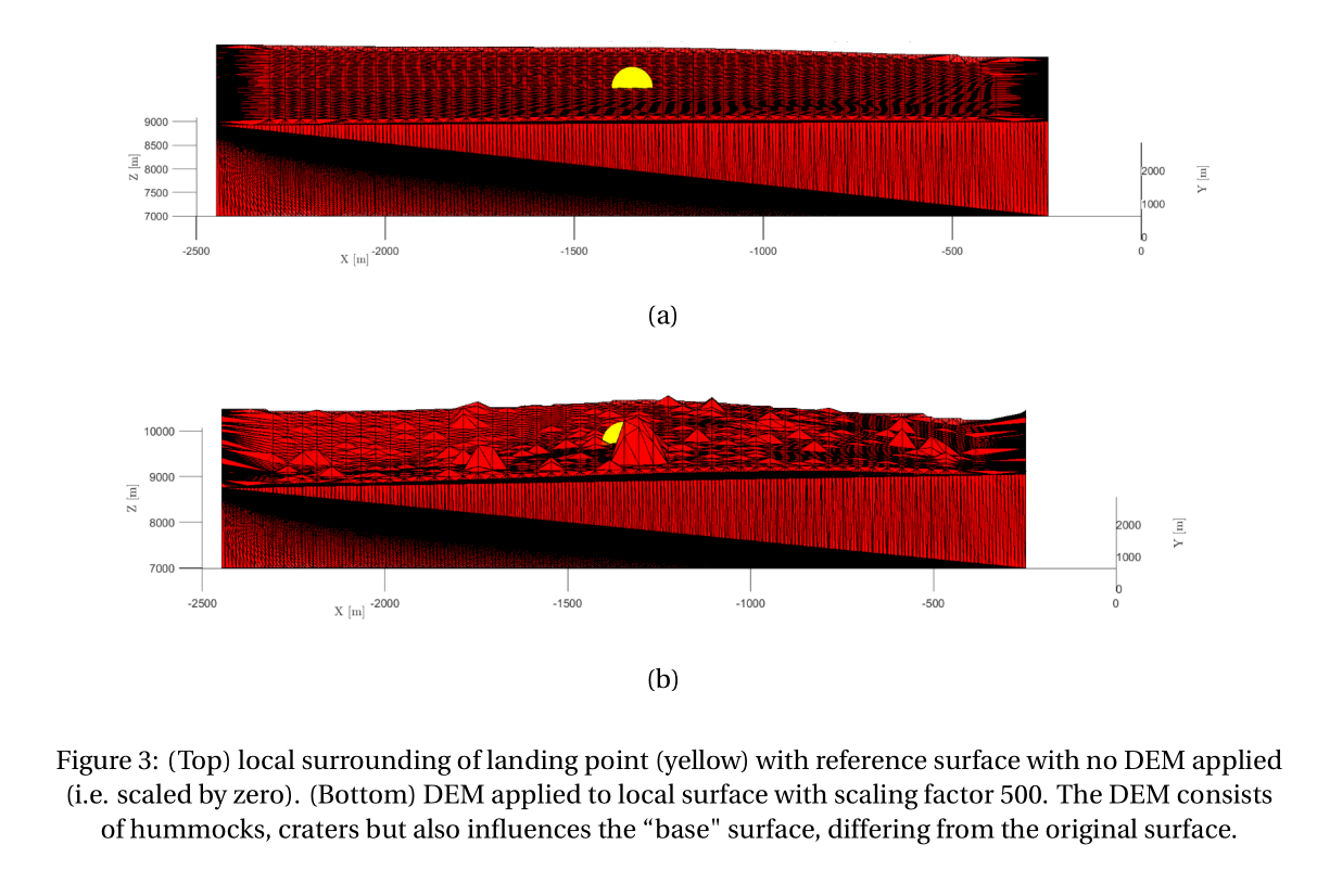
The influence of the DEM can now be found by comparing the gravity of the smooth (original) surface and the DEM surface. To avoid differences due to a different grid size, the smooth surface is in fact the DEM surface, but scaled by zero (Figure 3 (a) and (b), respectively). Generally, single features will be much larger than the average DEM topography, creating some unrealistically large features for larger scale factors. This can be solved with cutoff-constraints, as needed.
Results
The influence of the resulting gravity in one exemplary landing point for different DEM scale factors and different DEM resolutions was investigated. An artificial DEM with surface resolution of 1/40 pixel/m is used, where different sizes of the topographical features are investigated using a scale factor (0 for no local topography to 500 corresponding to hills of up to 375 m and one large hill of 1000 m). Here, a constant density of 1860 kg/m³ was applied. We calculate the difference of the smooth and DEM surface relative to the reference gravity. The DEM with scale factor 500 reduces the resulting gravity in the landing site by 1.4%. As expected, larger scale factors increase this even more and vice versa. This result was computed with a DEM resolution of 1/40 pixel/m. For scale factor 250, we find a change in gravity of 0.45%.
We likewise investigated the influence of the DEM resolution. The resolution is generally reduced from the original data set to limit the computation time of the WPM. Indeed, also the resolution of the applied DEM has an influence on the result. Changing the resolution from 1/100 pixel/m to 1/20 pixel/m changed the gravity influence by about 0.12% while fixing the scale factor. This difference was reduced a little to 0.11% by increasing the resolution further to 1/10 pixel/m.
In summary, the DEM influence on the local gravity using Wedge-Pentahedra Method (WPM) cannot be neglected for surface gravimetry science. Here, a scale factor of 500 and larger resulted in changes larger than 1% of the local gravity. We found that the terrain resolution has an influence on the gravity modelling, while it is more important to include all surface features than representing each individual feature with a high-resolution. Regarding landing and touch-and-go manoeuvres, the sensitivity to the here presented results should be investigated further.
Acknowledgements
M.N. acknowledges funding from the Foundation of German Business (sdw) and the Royal Observatory of Belgium (ROB) PhD grants. The authors acknowledge funding from BELSPO via the PRODEX Programme of ESA and from the European Union’s Horizon 2020 research and innovation program under grant agreement No. 870377 NEO-MAPP.
References
[1] Ulamec, Stephan, et al. A rover for the JAXA MMX Mission to Phobos. 70th International Astronautical Congress, 2019.
[2] Karatekin, Özgür, et al. Surface gravimetry on Dimorphos. No. EGU21-15901. Copernicus Meetings, 2021.
[3] Ritter, Birgit, et al. Surface Gravimetry on Dimorphos with GRASS on Juventas. IAA-PDC-21-0X-XX. IAA Planetary Defense Conference – PDC 2021.
[4] Werner, R.A., Scheeres, D.J. Exterior gravitation of a polyhedron derived and compared with harmonic and mascon gravitation representations of asteroid 4769 Castalia. Celestial Mech Dyn Astr 65, 313–344 (1996).
[5] Willner, K., X. Shi, and J. Oberst. Phobos' shape and topography models. Planetary and Space Science 102 (2014): 51-59.
[6] Miyamoto, Hirdy, personal communication, 2021.
How to cite: Noeker, M., Karatekin, Ö., Ritter, B., and Tasev, E.: Artificial terrain on Phobos: Assessing the influence on local gravity using the Wedge-Pentahedra Method, Europlanet Science Congress 2021, online, 13–24 Sep 2021, EPSC2021-370, https://doi.org/10.5194/epsc2021-370, 2021.