
Mud flows in the Southwestern Utopia Planitia, Mars
 1,1,2,3,1
- 1Czech University of Life Sciences Prague, Faculty of Environmental Sciences, Praha, Czech Republic (curin@fzp.czu.cz)
- 2Institute of Geophysics of the Czech Academy of Science, Prague, Czech Republic
- 3Institute of Planetary Research, German Aerospace Center (DLR), Berlin, Germany
Abstract
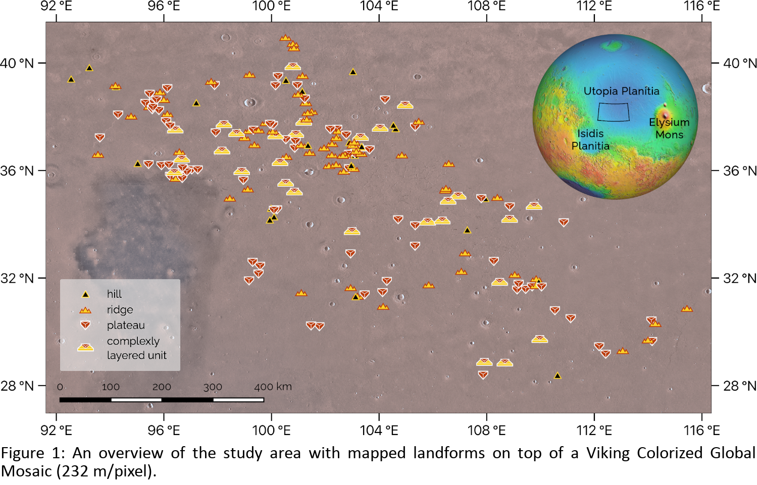
Here we present the results of our mapping of a large field of landforms characterized by flow-like morphology in the southwestern part of Utopia Planitia. They have been previously interpreted as mud flows associated with a partly frozen muddy ocean [1,2]. We find that these features can be grouped into four separate classes with distinct shapes and sizes and a clear evolutionary sequence among them. This suggests that all 205 studied features spread across the 500 × 1300 km large area were formed by the same basic process and that the material likely originated from the same source.
Introduction
The deepest parts of Utopia Planitia served as depocenters or sinks since early in the Martian history [2,3] and would be the final destination for any material released during Hesperian catastrophic floods [4]. Consequently, it was proposed that a large body of water might once or repetitively have been present there [1,5]. However, such hypothesis is still controversial due to the lack of unambiguous morphological evidence [6]. A promising area to search for such evidence is Adamas Labyrinthus, where the presence of putative mud flows has been previously reported [2,5].
Data and Methods
Our mapping is based on the global CTX Mosaic (5m/pixel) [7] which served as the base map for delineation of the observed features. The features were marked as point, linear, and polygonal features in a QGIS environment. HiRISE (0.3 m/pixel) and CTX stereo pairs were processed using the MarsSI service [8] to produce digital elevation models (DEM) for some studied landforms. This enabled us to calculate their basic morphometric characteristics, height and volume, but also to reveal the relative stratigraphy among them and their surroundings.
Results
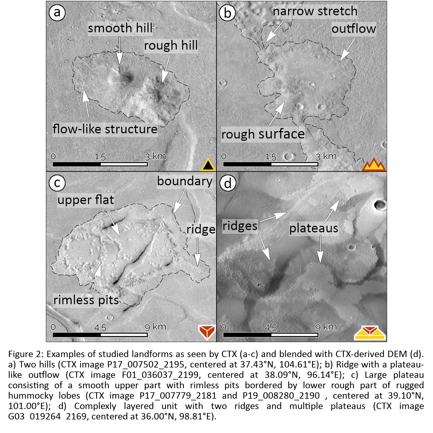
We found and mapped 205 features with positive topography characterized by flow-like appearance (Fig. 1). We classified them into four groups based on their extent, shape, and morphological properties (e.g., surface roughness). The resulting classes are ‘hills’ (Fig. 2a), ‘ridges’ (Fig. 2b), ‘plateaus’ (Fig. 2c), and ‘complexly layered units’ (CLUs, Fig. 2d), but we note that landforms commonly show transitional stages, hence share characteristics of multiple classes (such as in Fig. 2b).
Hills are the smallest studied features. They are characterized by circular plan-map appearance. Their surface texture can be either smooth or rough with flow-like structures extending beyond their bases (Fig. 2a). Hills can be solitary features or be associated with fractures, in which case they form hill chains. Ridges are elongated features with rough surface. They vary in width from narrow sub-kilometer stretches to wide and elevated smooth plateau-like features (see Fig. 2b) surrounded by hummocky rims. Plateaus (referred to in [2] as “etched flows”) are kilometer-sized features characterized by a smooth central uplifted unit usually surrounded by a rough boundary (Fig. 2c). The smooth unit often contains rimless pits. Plateaus sometimes superpose the polygonal throughs typical for Adamas Labyrinthus. The final type are CLUs represented by extensive and often chaotic combination of overlapping landforms mentioned above (Fig. 2d). Their relative stratigraphy is decipherable only with the use of DEMs.
Discussion
Previously, many flow-like features have been described elsewhere on Mars as lava flows [9,10]. At the first glance this might seem like a plausible scenario even here as the studied features bear many morphological similarities with terrestrial and martian lava flows. However, our survey did not reveal signs of subsidence or explosive excavation associated with studied features, which are commonly accompanying volcanic eruptions [e.g. 9,10]. We also did not find evidence of lava-water interactions (e.g., rootless cones) which would have favorable conditions to occur at this location as the studied features are superposed on terrain enriched in volatiles as documented by polygonal troughs, ghost craters and pedestal craters [2].
Instead, the morphological characteristics of the mapped features, transitions between their categories and the spatial context of the study suggest that the landforms are of sedimentary (mud) volcanic origin. Recently, Brož et al. [11] showed experimentally that low viscosity mud effusively emplaced onto the cold martian surface under the low atmospheric pressure of 7 mbar would behave similar to pahoehoe lava, and resulting landforms might have similar appearance. This is because the evaporative cooling of water would cause the formation of an icy crust on the surface of the mud flow, analogous to a solidified lava crust. This process might explain the observed shapes of the studied features.
Conclusions
We propose that the studied features were formed due to the expulsion of mud from a gradually freezing muddy body. Because of the climatic conditions on Mars such body would be freezing from the top down, causing an increase in the internal pressure of the still liquid mixture underneath. This would trigger the ascent of the mud towards the surface via cracks in the frozen crust and subsequent effusive eruptions. Once the mud would be exposed to the surface, it would spread by flowing over the surface, while freezing at the same time. This would limit its ability to flow but cause the resulting outflow to have an appearance similar to terrestrial lava flows. This process gave rise to the observed hills, ridges, plateaus and complexly layered units. Emergent landforms degraded over time as the volatile part of the compound sublimed away eventually leading to the characteristic morphology we observe today.
Acknowledgements:
VC, PB & YM were supported by Czech Science Foundation (#20-27624Y).
References:
[1] Jöns (1985), Lunar Planet. Sci. 16, 414–415; [2] Ivanov et al. (2014), Icarus 228, 121-140; [3] Frey et al. (2002), Geophysical Research Letters 29, no. 10, 22-1-22-4; [4] Carr (1996), Planetary and Space Science 44, 1411-1423; [5] Ivanov et al. (2015), Icarus 248, 383-391; [6] Sholes et al. (2021), Journal of Geophysical Research: Planets 126, no. 5; [7] Dickson et al. (2018), 49th Lunar and Planetary Science Conference 2018, LPI Contrib. No. 2083 ; [8] Quantin-Nataf et al. (2018), Planetary and Space Science 150, 157-170; [9] Hodges & Moore (1994), Atlas of volcanic features on Mars; [10] Hauber et al. (2009), JVGR 185, 69-95; [11] Brož et al. (2020), Nat. Geo. 13, 403-407
How to cite: Cuřín, V., Brož, P., Hauber, E., and Markonis, Y.: Mud flows in the Southwestern Utopia Planitia, Mars, European Planetary Science Congress 2021, online, 13–24 Sep 2021, EPSC2021-382, https://doi.org/10.5194/epsc2021-382, 2021.