
The Degas crater on Mercury: an interesting target for the BepiColombo mission?
 2,
2,- 1INAF – Osservatorio Astronomico di Roma, Monte Porzio Catone, Italy (nicolas.bott@inaf.it)
- 2LESIA, Observatoire de Paris, Université PSL, CNRS, Université de Paris, Sorbonne Université, Meudon, France
- 3INAF – Istituto di Astrofisica e Planetologia Spaziali, Rome, Italy
1. Introduction
Launched on October 19th, 2018 (local time) towards Mercury, the BepiColombo spacecraft carries 16 instruments onboard the MPO and MMO orbiters. The SIMBIO-SYS (Spectrometer and Imagers for MPO BepiColombo Integrated Observatory SYStem) instrument [1] will image the surface of the innermost planet of the Solar system at unprecedented high spatial and spectral resolutions. SIMBIO-SYS is composed of 3 channels: STC (STereo Channel), a stereo camera; HRIC (High spatial Resolution Imaging Channel), a multispectral camera with a very high spatial resolution; and VIHI (Visible Infrared Hyperspectral Imager channel), a hyperspectral imager characterized by high spectral resolution and signal-to-noise ratio. The establishment of the target list for SIMBIO-SYS is underway. Therefore, studying potential targets of interest can be very useful to support their selection.
2. Data and methods
Here, we analyse the Degas crater, localized in the Shakespeare quadrangle (H-03) [2,3], hence at mid-latitudes of the northern hemisphere of Mercury (37.08°N, 232.66°E). Degas has been classified as a Kuiperian (-1 Gyr – today) crater [4] notably because of its well-preserved ray system of ejecta. We used MESSENGER data to investigate this crater with a three-fold approch: a multispectral analysis based on MDIS-WAC (Mercury Dual Imaging System-Wide Angle Camera) images have been combined with a spectroscopic analysis of MASCS (Mercury Atmospheric and Surface Composition Spectrometer) spectra and a geological analysis based on MDIS-NAC (Mercury Dual Imaging System-Narrow Angle Camera) images.
3. Preliminary results
3.1. Multispectral analysis
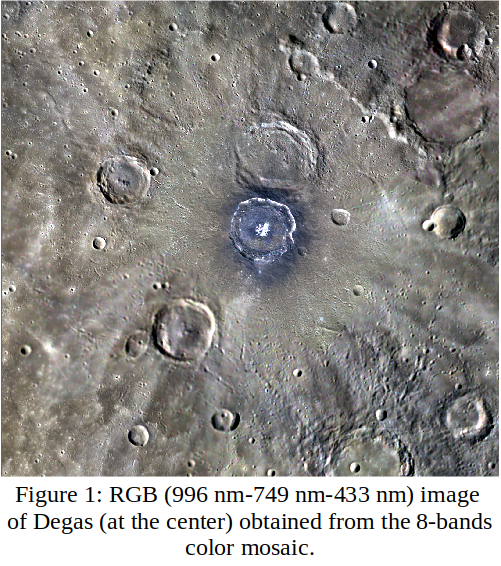
Using the MDIS-WAC images at the best spatial resolution available (95-250 m/pixel) and the Integrated Software for Imagers and Spectrometers (ISIS), we produced three color mosaics: an 11-bands mosaic to use all the multispectral information available with MDIS, an 8-bands mosaic to cover a wider area around the crater and study its surroundings (Figure 1), and a 3-bands mosaic with the best spatial resolution achievable (95 m/pixel).
We also produced two high-resolution monochrome mosaics using MDIS-NAC images on which geological analysis was performed (see Section 3.3).
A Principal Component Analysis (PCA) was applied to the 11-bands mosaic. The enhanced color image obtained using PC1 and PC2 reveals an asymmetric distribution of LRM (Low Reflectance Material) [5] around the crater, which suggests an oblique impact. Finally, a K-mean clustering highlights 4 spectral units: the blue deposit on the crater floor, the floor not covered by this deposit, the LRM surrounding Degas and the ejecta blankets. Close spectral properties between hollows and the blue deposit on the floor of Degas are also evidenced.
3.2. Spectroscopic analysis
MASCS spectra have been extracted from the four multispectral units (Figure 2).
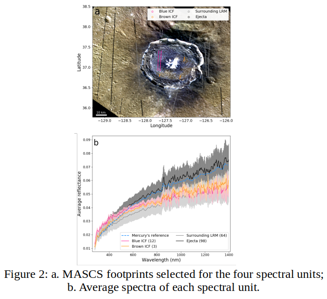
The spectral properties of both floor units differ in both the visible and the UV. To better highlight the variations of these spectral properties, we computed several spectral parameters: UV-downturn [6], reflectance at 750 nm, spectral slope in the visible, and spectral curvature [7]. We found that the two units of the floor have different visible slope and UV-downturn. Moreover, the blue deposit seems to have spectral properties similar to LRM, thus may contain such dark material.
3.3. Geological analysis
A high-resolution geological mapping of the Degas crater was performed on several NAC images mosaics of various spatial resolutions (Figure 3).
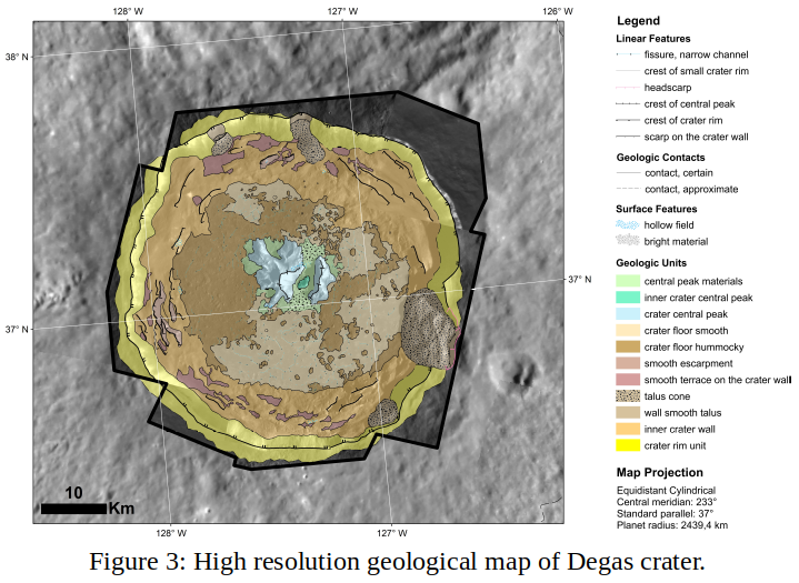
From a geological point of view, the floor is characterized by two different surficial textures mapped as smooth and hummocky crater floors. Dating of the floor shows a slightly younger age for the hummocky area than for the smooth area, but the floor as a whole is ~50 Ma younger than the ejecta. Finally, the central peak display hollows and bright materials at its base and an asymmetrical shape with a vergence towards East-South East. This provides another hint in favor of an oblique impact from North-North West, and is in good correlation with the LRM distribution around Degas.
4. Conclusion and perspectives
The crater Degas was probably formed by an oblique impact with a trajectory from North-North West to South-South East, and presents incredible geomorphological and compositional diversities. Its floor is morphologically and spectrally characterized by different materials, whose origins are still unclear (fall-back material or impact breccia for the hummocky area? Impact melt or resurfacing for the smooth area?). For these reasons, we strongly encourage closer observations of Degas with BepiColombo (SIMBIO-SYS, MERTIS, MIXS, MGNS and BELA).
Further results will be presented and discussed at the virtual talk.
Acknowledgements
This work is partly supported by the Centre National d'Études Spatiales. We gratefully acknowledge funding from the Italian Space Agency (ASI) under ASI-INAF agreement2017-47-H.0. The authors acknowledge the use of MESSENGER data.
References
[1] Cremonese, G, et al.: SIMBIO-SYS: Scientific Cameras and Spectrometer for the BepiColombo Mission, Space Sci Rev, 216, 2020.
[2] Guzzetta, L, et al.: Geology of the Shakespeare quadrangle (H03), Mercury, Journal of Maps, 13, 227-238, 2017.
[3] Bott, N, et al.: Global Spectral Properties and Lithology of Mercury: The Example of the Shakespeare (H-03) Quadrangle, JGR Planets, 124, 2326-2346, 2019.
[4] Banks, M. E., et al.: Revised constraints on absolute age limits for Mercury’s Kuiperian and Mansurian stratigraphic systems, JGR Planets, 122, 1010-1020, 2017.
[5] Klima, R. L., et al.: Global Distribution and Spectral Properties of Low-Reflectance Material on Mercury, Geophysical Research Letters, 45, 2945–2953, 2018.
[6] Goudge, T. A., et al.: Global inventory and characterization of pyroclastic deposits on Mercury: New insights into pyroclastic activity from MESSENGER orbital data, JGR Planets, 119, 2014.
[7] Barraud, O, et al.: Near-Ultraviolet to Near-Infrared Spectral Properties of Hollows on Mercury: Implications for Origin and Formation Process, JGR Planets, 125, 2020.
How to cite: Bott, N., Barraud, O., and Guzzetta, L.: The Degas crater on Mercury: an interesting target for the BepiColombo mission?, European Planetary Science Congress 2021, online, 13–24 Sep 2021, EPSC2021-412, https://doi.org/10.5194/epsc2021-412, 2021.