
Mapping height variations of seasonal ice cover at the Martian South Pole
 1,2,4,5,
- 1Technical University of Berlin, Institute of Geodesy and Geoinformation Science, Germany (haifeng.xiao@campus.tu-berlin.de)
- 2German Aerospace Center, Institute of Planetary Research, Germany
- 3Stanford University, Department of Geophysics, USA
- 4German Aerospace Center, Institute of Atmospheric Physics, Germany
- 5Université Paris-Saclay, CNRS, GEOPS, France
Abstract
Previously, we have proposed and validated the co-registration of local dynamic Mars Orbiter Laser Altimeter (MOLA) profile segments to static Digital Terrain Models (DTMs) as an approach for obtaining seasonal CO2 ice cover height variations on Mars. Building upon this, we introduce a post-correction procedure called “bi-RPCA” to further lower residual errors in the profiles and improve the precision of the height variation measurements. The ultimate goal is to apply this method to MOLA, SHAllow RADar (SHARAD) radar altimetry to generate long-term seasonal height change time series at the Martian poles with high spatial and temporal resolution.
1. Introduction
The dynamic growth and retreat of Martian polar CO2 ice/frost caps is one of the most important themes for the Red Planet’s climate [1, 2]. Accurate measurements of seasonal height and volume changes of snow and ice can serve as important constraints for models of Mars climate and the long-term evolution of the southern residual ice cap. Previously, we have proposed and validated the local co-registration between laser profile segments and high static resolution DTMs in obtaining the temporal height variations at local scale [3]. Building upon that, we now propose a post-correction procedure called “bi-RPCA” to further improve the precision of the obtained height variation time series.
2. Data
The Mars Orbiter Laser Altimeter (MOLA) Precision Experimental Data Record (PEDR) dataset includes a total of 8505 profiles, acquired in the mapping and extended phases of Mars Global Surveyor (MGS) from February, 1999 to May, 2001, which spanned approximately a full Martian year [1]. The PEDR dataset was processed using a MGS orbit trajectory- and a Mars rotational model by GSFC dating back to 2003. Therefore, we reprocessed the MOLA data, incorporating a refined orbit model from [4] and the IAU2015 Mars rotational model [5] for new MOLA geolocations. To account for the special relativity effect, a pointing aberration correction has also been applied in the reprocessing [6].
3. Methods
3.1. Self-registration technique
To build coherent reference DTMs of the average Martian surface at South Pole [78°S, 87°S] and an annulus centered at 50°S ([44°S, 56°S]), we resort to the self-registration of the reprocessed MOLA profiles [7, 8].
3.2. Localized co-registration
In order to obtain the height change series, the following steps are performed. First, small segments of the MOLA profiles consisting of a few hundred footprints are co-registered to the reference DTM. In this step we use a window, which is moved along the footprints. The obtained height corrections are assigned to the central footprint within the window. Hence, one obtains an individual height correction for every footprint within the MOLA profile and observation epoch. Finally, the CO2 height change time series are obtained by median-binning those temporal height differences with the precision quantified by scaled median absolute deviation. We name this method “F_LC” [3], where “F” stands for footprints and “LC” the local co-registration.
3.3. Post-correction by regional pseudo cross-over adjustment
The regional crossover adjustment (RCA) over a relatively small & non-dynamic areas has been extensively used to improve the internal consistency of biased altimetry profiles on Earth [9]. Here, we adopt the DTM-based pseudo cross-overs acquired within 5 Earth days instead of the traditional cross-overs in the process as the regional pseudo cross-over adjustment (RPCA) for post-correction purposes. Pseudo cross-overs are formed by two profile segments that do not necessarily intersect. However, the connection between the profiles is established by a DTM overlapping with both profiles. Hence, the height difference between these (not necessarily crossing) profiles is obtained by the difference of their height corrections with respect to the self-registered DTM. Due to the inclusion of these pseudo cross-overs the number of “cross-overs” is increasing significantly [10]. The height correction is assumed to be constant for each profile segment. “Bi-RPCA” consists of two consecutive RPCA processes. By performing the RCPA at 50°S annulus, where no seasonal effects are expected, we obtain corrections for a systematic temporal bias within the MOLA data [2]. By assuming that the correction for a specific profile does not change from 50°S to the polar area, we apply the same corrections for profiles at the polar regions. The second RPCA step is carried out in the polar region to obtain height corrections to improve the self-consistency of the profiles, and hence the precision of the obtained temporal height variation using "F_LC".
4. Results
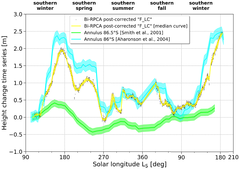
Figure 1: Temporal height variation for a polar region along 86°S ([85.75°S, 86.25°S, 270°E, 280°E]) by our “F_LC” & bi-RPCA approach in comparison with results for an annulus at 86.5°S [1] and 86°S [2].
An example of the obtained temporal height variation in study region on the residual ice cap using “F_LC” and post-corrected by “bi-RPCA” is shown in Figure 1. The peak-to-peak height variation is ~2.5 m, similar to that of [2]. However, the peak height in MY25 is ~0.5 m higher than that of MY24, indicating annual variations. The off-season accumulation in southern summer and fall resolved in [2] are clearly visible in our result. The precision quantified by scaled median absolute deviation (the yellow shade in Figure 1) is ~4 cm, much improved over the ~50 cm of the “F_LC” result without the “bi-RPCA” post-correction [3].
5. Summary
We propose the “bi-RPCA” post-correction procedure to simultaneously compensate for systematic temporal bias and remove residual errors in the reprocessed MOLA profiles. The obtained height variation time series at the study region is reaching a high precision of ~4 cm. Thus, in future work the combination of “F_LC” & “bi-RPCA” will be applied to the entire polar regions to map the spatial distribution of the varying depth of the seasonal ice caps.
Acknowledgements
H. Xiao thanks China Scholarship Council (CSC) for financial support of his study in Germany. Part of this research was carried out within the framework of the DLR BigData Querschnittsplattform.We acknowledge the work by the MOLA instrument and science teams.
References
[1] Smith et al., Science, 2001, 294, 2141-2146. [2] Aharonson et al., JGR Planets, 2004, 109(E5). [3] Xiao et al., EPSC2020, vol.14, No. 181. [4] Konopliv et al., Icarus, 2006, 182, 23-50. [5] Konopliv et al., Icarus, 2016, 274, 253-260. [6] Xiao et al., JoG, 2021, 95(2), 1-23. [7] Stark et al., EPSC2018, Contrib. No. 890. [8] Stark et al., GRL, 2015, 429, 7881-7889. [9] Ewert et al., J. Geodyn., 2012, 59-60, 111-123 [10] Barker et al., Icarus, 2016, 273, 346-355.
How to cite: Xiao, H., Stark, A., Steinbrügge, G., Thor, R., Schmidt, F., and Oberst, J.: Mapping height variations of seasonal ice cover at the Martian South Pole, Europlanet Science Congress 2021, online, 13–24 Sep 2021, EPSC2021-428, https://doi.org/10.5194/epsc2021-428, 2021.