
Chains of small cones and a cycloid form at Chryse Planitia on Mars
 2,4,
2,4,- 1University of Warsaw
- 2Space Research Center PAS, ul. Bartycka 18 A, 00-716 Warszawa, Poland,
- 3Space Research Center PAS, ul. Bartycka 18 A, 00-716 Warszawa, Poland, Presently: Institute of Geological Science PAS, ul. Twarda 51/55, 00-818 Warszawa, Poland
- 4Copernicus Science Centre, ul. Wybrzeże Kościuszkowskie 20, 00-390 Warszawa, Poland,
- 5Lukasiewicz Research Network - Institute of Aviation, Al. Krakowska 110/114, 02-256 Warszawa, Poland
- Introduction:
Small cones are common on Mars. Many cones form chains several kilometers in length. The mechanisms of their formation are not explained. Cycloid forms are observed in a few places. Their origin is also unknown.
We consider a small region in Chryse Planitia where several chains of cones are found – Figs. 1, 2, 3. The cones height are ~20 m. The considered region is at the boundary of smooth plain on west (AHcs) and complex unit (AHcc) on east. The small region (HNck) in north-west corner of figure is the “older knobby material” – [1]. AH means Amazonian-Hesperian and HN - Hesperian-Noachian. The region is covered by lacustrine deposits. Some volcanic activity was possible in HNck.

Fig. 1. Our region in Chryse Planitia. Its part is presented in map at Fig. 2 (white rectangular, bold dashed line). The region is at the boundary of smooth plain (AHcs) and complex unit (AHcc) – Rotto and Tanaka (1995). The dotted black arrow a3 indicates structure presented in Fig. 4. The cycloid arcs are marked with letters c.
- Our hypothesis of cones origin:
Generally we consider 3 mechanisms of these cones formation: (i) a grains’ ejection, (ii) from mud or fluidized sand and (iii) explosive formation. Of course, the cones may be formed by several processes.

Fig. 2. Topography of the region shown in the dashed rectangle in Fig. 1. Topography is based on MOLA/HRSC Blended Digital Elevation Model 200 m on THEMIS Day IR layer. Data resolution is rather low, therefore, some smaller structures may not be visible on the map and non-existent artifacts may be found.
The chains labeled 1, 2, 3, 4, 5 are probably formed along outcrops of aquifers. The chains 7 and 8 of cones follow the course of valleys quite well. Therefore, it is difficult to expect that these cones are of igneous volcanism. Our hypothesis predicts the following scenario: (i) the regolith at the valley floor contained significant amounts of water left over from the floods. (ii) In the next stage, there was an overflow of lava in the vicinity of the area (HNck). This lava flowed into the valley creating a series of rootless cones. The material ejected by the explosion covered the valley and the slopes of the neighboring hills. (iii) Later, the lower structures (including the valley floor) were covered with fine aeolian sediments. This scenario is confirmed by thermal inertia observations.
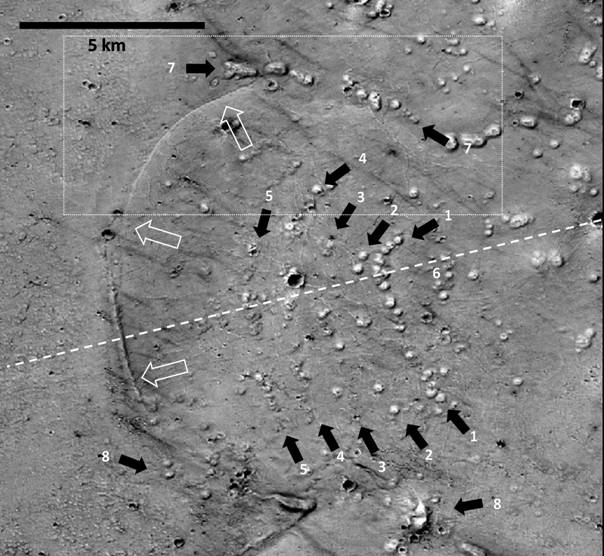
Fig. 3. The part of considered region (see Fig. 1). The chains of cones are indicated by solid black arrows and labeled by numbers 1, 2, 3, 4, 5. According to one of our hypotheses, some of these chains were formed along the outcrops of sediments with high content of volatiles. The chains of cones 7 and 8 may have been formed as rootless cones at the bottom of the valleys (side channels). The open arrows indicate the part of cycloid. NASA, P22_009485_2187_XN_38N040W.
- The cycloid
Consider now the structure extending north of the impact crater marked C1 in Fig. 1. It is a cycloid-like structure. It is marked by letters 'c'. It runs mostly on the western slopes of the hills - Fig. 2.
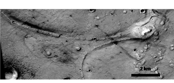
Fig. 4. The place where two cycloids meet. Note small cones on both arcs and the fact that both arcs run at the same height. This is an enlargement of part of Fig. 1 (arrow a3). NASA, CTX image P22_009485_2187_XN_38N040W.
Most cycloid arcs do not touch each other because they are separated by the side channels.
Let us consider Fig. 3. In the southern part of the hill there is no well-defined cycloid. One can see only several cones placed at the foot of the hill. This may be a result of the destruction of the original structure of cycloid during formation of cones. In the middle part, we observe a narrow embankment on the slope that is running approximately at halfway up the hill. The best preserved cycloidal structure is seen (as a belt of ~100 m wide) only since the end of the embankment (i.e., on northern part of Fig. 3). The belt runs approximately horizontally along the contour of the hill. The cycloidal arcs may be outcrops of a layer making up parts of the adjacent hills.
This possibility is supported by morphology seen in Fig. 4. It shows the confluence of adjacent arcs of cycloid. Both arcs are covered with small cones and extend at the same height. They could be outcrops of the same layer.
Also note that the cycloid arc on the hill shown in Fig. 3 lies at the same height as chain of cones 1. So maybe the cycloid arc and the chain 1 lay along outcrops of the same layer. Arc of cycloid is an outcrop on the west slope, while chain 1 marks an outcrop on the east slope of the hill. The lack of larger cones on the arc of cycloid could be a result of less intensive heating or lower amount of volatiles in western part of the layer comparing to eastern part.
The arcs marked with 'd' in Fig. 1 seem to be similar to the cycloid arcs discussed above. However, the topography of the area along the 'd' arcs is significantly different, so we conclude that such statement is premature.
- Conclusions;
Two different origins of cones we suggest: along outcrops of aquifers and as rootless cones [2]. The cycloid could be also a result of activity along outcrops of aquifers.
Acknowledgments: This study was supported by statutory project of Institute of Geophysics of University of Warsaw. We are also grateful to prof. W. Kofman and dr. J. Ciążela for their remarks.
References
[1] Rotto, S., Tanaka, K. L. (1995) Geologic/ geomorphologic map of the Chryse Planitia: region of Mars. USGS. [2] Czechowski L., et al. (2020), Cones chains in Chryse Planitia and some thermodynamic aspects of their formations. submitted.
How to cite: Czechowski, L., Zalewska, N., Zambrowska, A., Ciazela, M., Witek, P., and Kotlarz, J.: Chains of small cones and a cycloid form at Chryse Planitia on Mars, European Planetary Science Congress 2021, online, 13–24 Sep 2021, EPSC2021-434, https://doi.org/10.5194/epsc2021-434, 2021.