
Landform analysis of craters on the Permanently Shadowed Regions, Mercury
 1,2,2,2,
- 1Center of Studies and Activities for Space "G. Colombo" (CISAS), Padova, Italy; (silvia.bertoli.3@phd.unipd.it)
- 2INAF-OAPD, Astronomical Observatory of Padova, Padova, Italy.
In 1991, the Earth-based radar observations by both Goldstone and the Very Large Array revealed areas with high radar backscatter within Mercury’s north polar region [1]. These radar-bright materials have been interpreted as water ice deposits located within the permanently shadowed regions (PSRs) of polar craters due to the similar radar characteristics between them and those observed on Martian polar ice caps. This interpretation is also supported by the thermal models constructed by [2], which indicated that Mercury’s polar environments are capable of hosting stable water-ice deposits at the surface or shallow subsurface for geologic timescales. In addition, multiple data sets from the MErcury Surface, Space ENvironment, GEochemistry, and Ranging (MESSENGER, [3]) mission measured high hydrogen concentrations confirming that these radar-bright materials are predominantly composed of water ice [4]. On the other hand, measurements of surface reflectance of permanently shadowed areas also reveal regions of anomalously dark and bright deposits at 1064 nm wavelength that are concentrated on poleward facing slopes and spatially collocated with areas of high radar backscatter. Correlation of observed reflectance with modeled temperatures indicates that the optically bright regions are consistent with surface water ice, whereas dark regions are consistent with a surface layer of complex organic material that overlies buried ice and provides thermal insulation [5].
Figure 1 shows the radar image of Mercury’s north polar region where yellow spots are representative of water ice deposits located within impact craters. The analysis of such craters can provide new insights into the behavior of water ice deposits and the landscape evolution. For this reason, in this work, we investigate the morphology of eleven craters located at latitude over 80° N. We chose such craters because they are situated in a high-density region of MLA tracks and host low-reflectance deposits. In particular, Ensor, Bechet and Fuller craters have been selected for the presence of brightness variations associated with secondary impact craters [6], while Jimenez, Kirby, Josetsu and Sapkota craters for their poor radar bright signals.
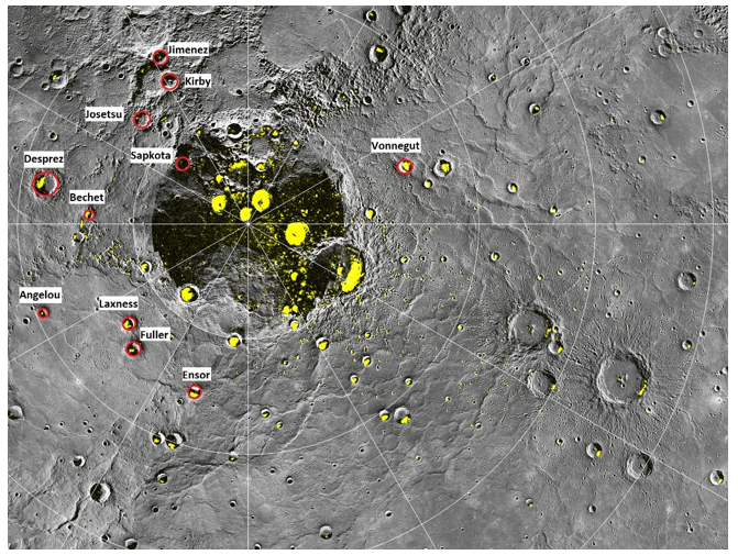
Fig.1 - The highest-resolution radar image of Mercury’s north polar region made from the Arecibo Observatory [7] is shown in yellow on a mosaic of MESSENGER orbital images. The red circles outline the craters analyzed in this work. Image credit: NASA/Johns Hopkins University Applied Physics Laboratory/Carnegie Institution of Washington
We are performing a high detailed geomorphological mapping of each impact crater (the preliminary work on Fig.2) using the highest resolution MDIS (Mercury Dual Imaging System [8]) image and, in addition, we will perform morphometric analysis using the MLA (Mercury Laser Altimeter [9]) data. Through the detailed analysis of the features and structures located within the selected impact craters, we will investigate their similarities and differences aiming to explain how the presence of the ice water deposits could affect their landscape and evolution.

Fig 2 – A preliminary mapping of Ensor crater. The data are managing in GIS environment and photointerpretation led to the identification of different units.
Acknowledgement: This activity has been realized under the BepiColombo ASI-INAF contract no 2017- 47-H.0.
References: [1] Butler B. J. et al. (1993) JGR 98, 15003-15024; [2] Paige D. A. et al. (1992) Science 258, 643-646; [3] Solomon S. C. et al., (2007) Space Sci. Rev. Space Sci Rev 131, 3–39 [4] Chabot N. L.., et al. (2018a), in Mercury: The View After MESSENGER, ed. S. C. Solomon et al. (Cambridge: Cambridge Univ. Press) 13; [5] Neumann G. A. et al., (2012) Science; [6] Deutsch A. N. et al. (2019) Earth and Planetary Science Letters 520, 26-33; [7] Harmon J. K. et al. (2011) Icarus 211, 37-50; [8] Hawkins S. E. et al. (2007) Space Sci Rev 131, 247–338; [9] Cavanaugh J.F. et al. (2007) Space Sci Rev 131, 451–479.
How to cite: Bertoli, S., Lucchetti, A., Pajola, M., and Cremonese, G.: Landform analysis of craters on the Permanently Shadowed Regions, Mercury, European Planetary Science Congress 2021, online, 13–24 Sep 2021, EPSC2021-471, https://doi.org/10.5194/epsc2021-471, 2021.