
Ganymede Cratering Record
 1,2,3,2,
- 1University of Napoli Parthenope, Sciences and Technologies, Napoli, Italy (elena.martellato@collaboratore.uniparthenope.it)
- 2INAF - Institute for Space Astrophysics and Planetology, Roma, Italy
- 3Southwest Research Institute, Boulder, CO, USA
JUICE, JUpiter ICy moons Explorer, the ESA mission planned to be launched in 2022 and to arrive at Jupiter in 2029, will make detailed observations of Jupiter and three of its largest moons. One of its goals is to improve the current estimates of Ganymede surface age [2].
Ganymede was observed firstly by Voyager 1 and 2 in 1979, and then by Galileo between 1996 and 2000 through six flybys, which revealed that the surface has two main types of terrains, which differ in albedo, crater density, and surface morphology [4]. The first one, the “dark” terrains, is low albedo terrains, covered by regolith material, and heavily cratered. The second one, the “light” terrains, has higher albedo and lower crater density, suggesting a younger age. They can occur as smooth elongated and polygonal shaped areas, or as grooves. An accurate chronology for Ganymede can therefore provide information about resurfacing and the evolution of the surface, including the extent of the cryovolcanism [3].
As part of the future activities, we make new crater counts to be then used to refine current Ganymede crater-based chronology. The quantitative and statistical analysis of impact crater populations is the primary tool to derive absolute ages of planetary and small body terrains. Further information to improve surface landform interpretation and crater counts can be derived from the crater morphological “freshness”, which may represent a first qualitative hint to the relative ages of individual craters and the surrounding area.
The goal of this project is to improve Ganymede crater chronology using the most updated understanding on the current and historical impact flux resulting from recent dynamical models. In this work, we will present our results in i) improving the geological mapping of the Ganymede surface, and in ii) deriving a revised crater database for Ganymede.
The present global image mosaic of Ganymede is available at a resolution of ~1 km/pixel. Being only 74% of the surface at a resolution better than 2 km/pixel, either image resampling or degradation was applied [1], [4]. We select the areas of Ganymede acquired at the highest resolution (<100 m/pixel).
On the existing global geological map [1], [4], we performed cartographic refinement to better define the contours of the geological units used in this study. Crater counting is then performed by selected impact structure by means of photo-interpretation (e.g., primary vs secondary, degradation degree, peculiar morphology, ejecta blanket, etc.). In Figure 1, we show a sample of the regions we analysed, while in Figure 2 we report the respective cumulative plots.
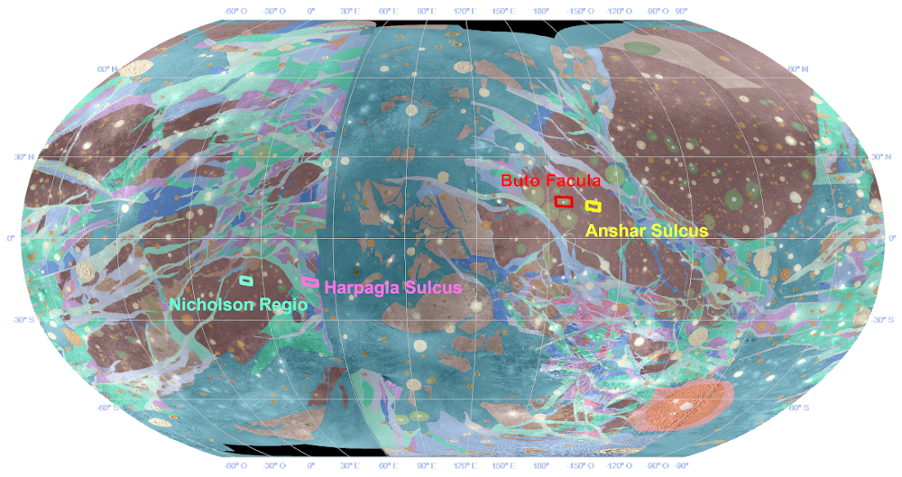
Fig. 1. Ganymede with overlaid the geological interpretation of its terrains (modified from Collins et al. 2013; Patterson et al. 2010). The four boxes refer to the areas of counts: Nicholson Regio in water green, Harpagia Sulcus in pink, Buto Facula in red, and Anshar Sulcus in yellow. The map is a Robinson projection, centred at 110°.
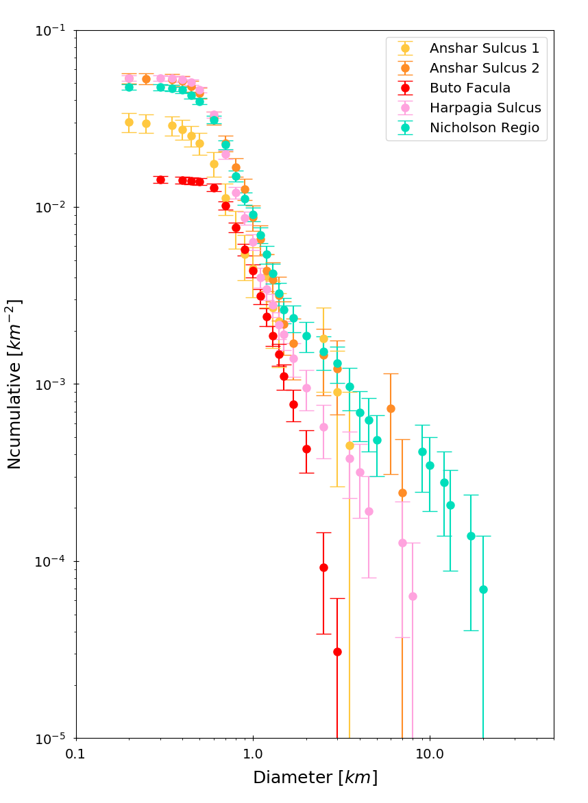
Fig. 2. The plot shows the comparison of the crater counts on the regions marked in Figure 1, represented as a cumulative distribution.
The precision of crater counting is crucial to derive reliable age estimates. Factors affecting the shape of the crater size−frequency distribution are: (i) contamination due to secondary craters and/or volcanic structures; (ii) ejecta blanketing; (iii) superposition, abrasion, and infilling; (iv) image resolution; and (v) illumination conditions.
We quantitatively estimate the accuracy of our counts by selecting sub-areas for which we have images available also at a spatial resolution better than a factor of five. We made there a second additional count, and made a direct comparison of the craters counted in these sub-areas when using either the image at lower or higher resolution.
As displayed in Figure 3, we found that craters counted in the low resolution images are often larger than the true value, due to a poor identification of the crater rim. Moreover, we marked as primary a number of crater-like features, which display a circular shape with an inner shadow in the low resolution image, but they then turn out to be an erroneous detection when cross-checking in the high resolution image.

Figure 3. Harpagia Sulcus at ~116 m/pixel (top) and ~16 m/pixel (bottom). The two boxes in this figure emphasize two of the main errors found in crater detection.
References.
[1] Collins et al.: Global geologic map of Ganymede. U.S. Geological Survey Scientific Investigations Map 3237, scale 1:15,000,000, http://pubs.usgs.gov/sim/3237/, 2013.
[2] Palumbo et al. (2014): JANUS: The Visible Camera onboard the ESA JUICE mission to the Jovian system. 45th LPSC, abstract #2094.
[3] Pappalardo, R.T., et al.: Geology of Ganymede, in: Bagenal, F., Dowling, T., McKinnon, W. (eds), “Jupiter”, Cambridge University, Press, Cambridge, UK, pp. 363–396, 2004.
[4] Patterson, G.W. et al.: Global geological mapping of Ganymede. Icarus, Vol. 207, pp. 845–867, 2010.
How to cite: Martellato, E., Marchi, S., Galluzzi, V., Palumbo, P., and Rotundi, A.: Ganymede Cratering Record, European Planetary Science Congress 2021, online, 13–24 Sep 2021, EPSC2021-576, https://doi.org/10.5194/epsc2021-576, 2021.