New Geological Studies and Crater Size-Frequency Distributions of Apollo Landing Sites and their Future Implications.
- Westfälische Wilhelms-Universität, Institut für Planetologie, Münster, Germany (iqbalw@uni-muenster.de)
Introduction
The data collected during the Apollo missions played a decisive role in shaping our knowledge of the Moon and its geological features. Up until today this data collection helps us to understand the ongoing processes occurring on the Moon and throughout the Solar system. The method of gaining absolute model ages (AMAs) of unsampled surfaces through crater size-frequency distribution (CSFD) measurements using the lunar cratering chronology was one of the many innovations of these missions. Recent improvements in the remote sensing data have helped to establish more accurate methods to further comprehend the processes on the Moon, as well as to test previously used methodology.
We conducted a series of studies [1-4] to test the validity of the commonly used lunar cratering chronology function [5]. The studies used recent available data to create detailed geological maps and CSFD measurements, which later were correlated with most recently measured sample ages.
Methodology
Lunar Reconnaissance Orbiter Cameras (LROC) Wide Angle (WAC, ~100m/px) and Narrow Angle (NAC, ~0.5m/px) data with incidence angles between 55-80° [6], and SELENE (Kaguya) morning, evening, ortho-image (~10 m/px) data were used to identify albedo variations. Merged LOLA/SELENE (~60 m/px) [7] and NAC-derived digital terrain models (DEMs) (~2.5 m/px) [8] were used to define morphological differences, whereas Clementine [9], Chandrayann-1 Moon Mineralogy Mapper (M3) [10] and Kaguya Multiband Imager (MI) [11] defined spectral variations. CraterTools [12] was used in ArcGIS for the CSFD measurements, and CraterStats [13] was used to plot the CSFDs. Randomness Analysis [14] was used to avoid secondary crater chains and clusters.
For geological mapping we relied on Federal Geographic Data Committee (2006) [15] standards for the symbology, and Gazetteer of Planetary Nomenclature (1999) [16] regarding the nomenclature. Meanwhile, stratigraphic units were identified using the stratigraphic scheme of Wilhelms (1987) [17].
Testing the Lunar Chronology Function
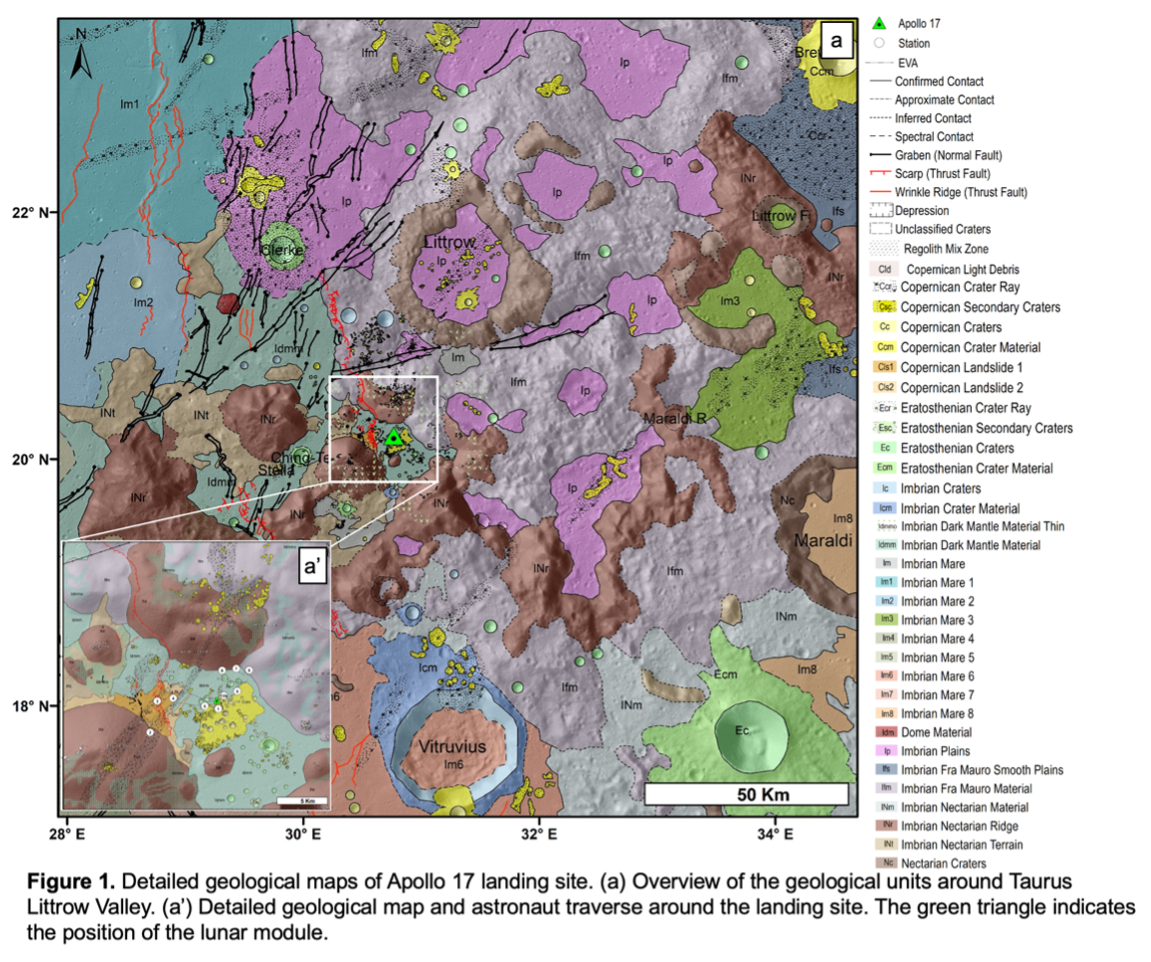
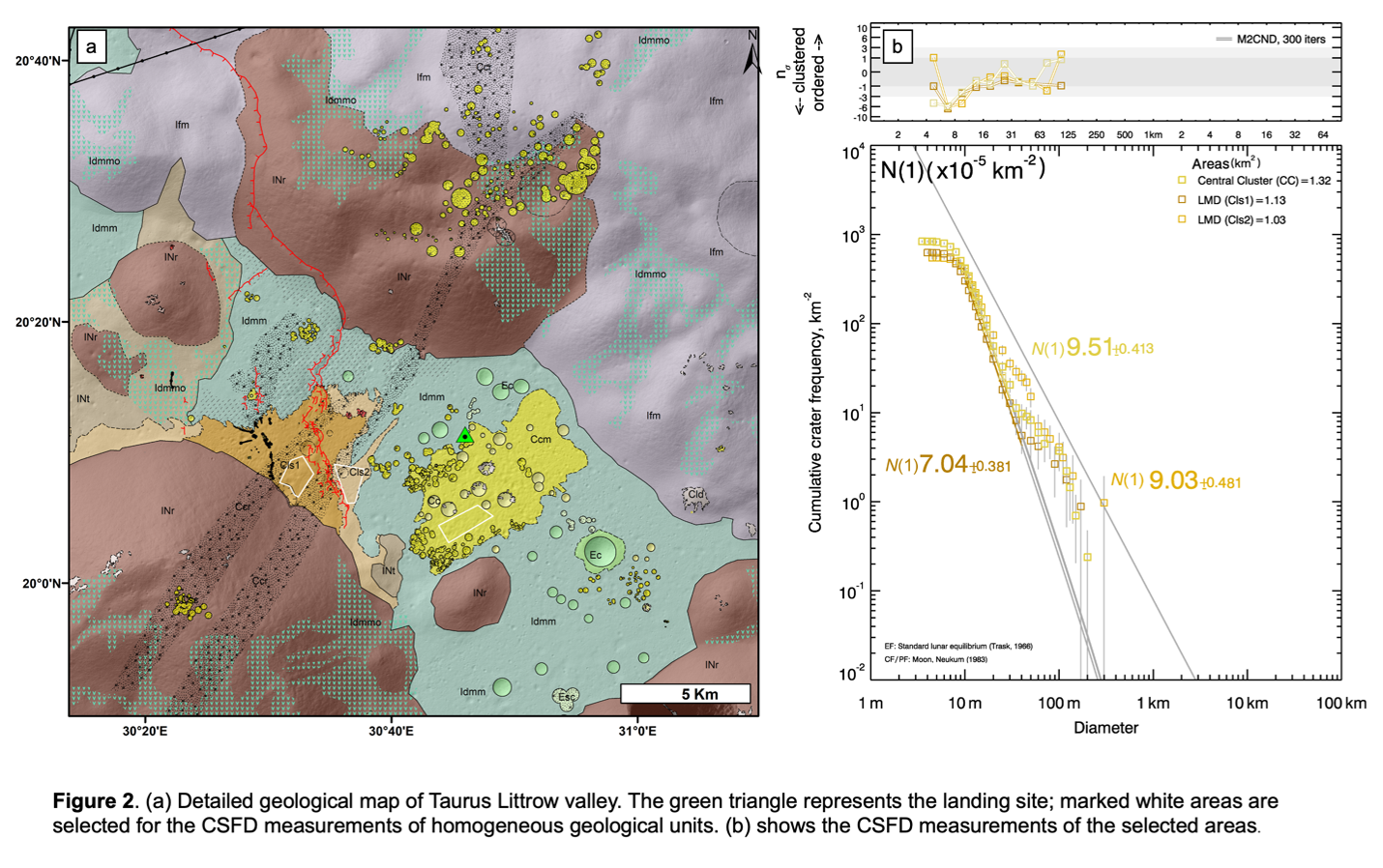
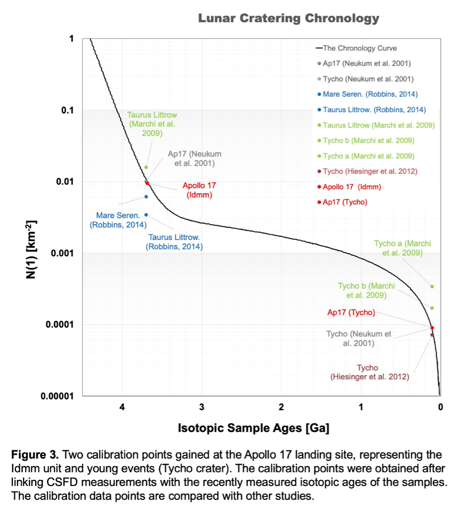
In our series of studies [1-4] we produced several detailed geological maps (e.g., Figure 1) of the Apollo landing sites, which were eventually used to measure CSFDs (e.g., Figure 2) on the defined geologically homogeneous areas. The gained N(1) (cumulative number of the craters ≥1 km in diameter) values were linked with the recently measured isotopic ages of the Apollo samples. The gained calibration points were used to test the calibration of the lunar cratering chronology [5] (Figure 3). The extrapolation of the tested lunar cratering chronology function is used to derive absolute model ages (AMAs) of the unsampled surfaces, which enables us to understand the evolution and ongoing processes of other terrestrial bodies in the solar system.
Other Implications
Our detailed geological maps provide advanced perspectives on the relationship of the samples and the remotely sensed compositional and morphological differences. Therefore, our studies are being used to investigate the exact origin of the collected samples [18].
Furthermore, our studies provide a comprehensive view on the scientific goals behind the landing site selection. Therefore, these studies can be used to assess future landing sites for the demonstration of in situ resource utilization (ISRU) missions [19].
Newly prepared comprehensive geological maps and carefully measured CSFDs will provide key domain knowledge for the development of tools to perform automatic detection of various features (e.g., craters). Such a tool will be integrated into the multi temporal data base (MUTED) [20], which will be able to show temporal differences on the planetary bodies instantaneously. In future, this tool will aid the interpretation of geological processes and help determining AMAs of planetary surfaces, while reducing cognitive bias and systematic errors.
Acknowledgements
WI, TH and NS were funded by German Aerospace Center (Deutsches Zentrum für Luft- und Raumfahrt) Grant #50OO2102. HH was funded by the German Research Foundation (Deutsche Forschungsgemeinschaft SFB-TRR170, subproject A2) and CvdB was supported by EU H2020 project #776276, PLANMAP.
References
[1] Iqbal et al. (2019) Icarus 333, 528-547. [2] Iqbal et al. (2020) Icarus 3352, 113991. [3] Iqbal et al. (2019) LPSC 50, 1005. [4] Iqbal et al (2020) LPSC 49, 1073. [5] Neukum (1983) NASA TM-77558 [6] Robinson et al (2010) Space Sci. Rev. 150, 81-124. [7] Barker et al. (2016) Icarus 273, 346-355. [8] Henriksen, et al. (2017) Icarus 283, 122-137. [9] Pieters et al. (1994) Science 266, 1844-1848. [10] Isaacsom, et al. (2013). JGR Planets. 118, 369-381. [11] Ohtake et al (2013) Icarus 226, 364-374. [12] Kneissl et al. (2011). PSS 59, 1243-1254. [13] Michael et al. (2016) Icarus 277, 279-285. [14] Michael et al. (2012) Icarus 218, 169-177. [15] FGDC (2006). FGDC-STD- 013-2016. [16] Blue, J. (1999) Gazette. of Planet. Nomen. USGS. [17] Wilhelms, (1987) USGS Prof paper: 1348.[18] Haber, et al (2018) AGU, P31G- 3785. [19] van der Bogert, et al. (2020) LPSC 51, 1876. [20] Heyer et al. (2021) LPSC 52, 1124.


How to cite: Iqbal, W., Hiesinger, H., van der Bogert, C., Heyer, T., and Schmedemann, N.: New Geological Studies and Crater Size-Frequency Distributions of Apollo Landing Sites and their Future Implications., Europlanet Science Congress 2021, online, 13–24 Sep 2021, EPSC2021-634, https://doi.org/10.5194/epsc2021-634, 2021.

