- 1IRAP, Toulouse, France (agnes.cousin@irap.omp.eu)
- 2USGS, Flagstaff, USA
- 3IMPMC, Paris, France
- 4LPG Nantes, Nantes, France
- 5IPAG, Grenoble, France
- 6Université de Lyon, Lyon, France
- 7LANL, Los Alamos, USA
- 8McGill University, McGill, Canada
- 9University of Copenhagen, Copenhagen, Denmark
- 10DLR, Berlin, Germany
Context On February 18th 2021, the Perseverance rover (NASA Mars 2020 mission) landed at Jezero crater, an ancient open-basin lake system measuring 50 Km in diameter. More precisely, the rover landed at the Octavia E. Butler Landing Site, which is located East of the delta in a dark crater floor unit, interpreted as the Undifferentiated Smooth Unit, between two distinct units: “Crater Floor Fractured 1” and “Crater Floor Fractured Rough” units. Since the landing, the rover has traveled around 40 m North and 60 m East from its initial location. From CRISM orbital data, this region is mainly pyroxene-bearing, with some olivine and hydrated minerals [1-3].
On-board the Perseverance rover, the SuperCam instrument [4-5] is being used as a remote-sensing facility to analyze rocks and soils targets. SuperCam is a suite of five coaligned techniques: just like ChemCam (onboard MSL/Curiosity rover on Mars since 2012), it uses the Laser Induced Breakdown Spectroscopy (LIBS) technique to determine the elementary composition of the targets, but it also uses Raman (for the first time in planetary science) and visible-infrared (VISIR - for the first time in situ) spectroscopic methods in order to access some mineralogical and structural information. A microphone gives access to some physical parameters of the sampled rocks (such as hardness [6]) as well as to some atmospheric parameters (wind direction [7]). These chemical and mineralogical analyses are contextualized thanks to a color remote micro-imager (RMI). In this study, we focus mainly on the LIBS results obtained so far.
Method We have used all the processed LIBS spectra acquired since the landing. Spectra have been processed with the following steps: denoise, background removal, wavelength calibration.
The SuperCam/LIBS technique can predict major elements such as SiO2, TiO2, Al2O3, FeO, MgO, CaO, Na2O, and K2O. The quantification of the LIBS data is achieved based on multivariate models, trained on more than 1000 spectra from 334 different known samples acquired in laboratory before launch [8-9]. Minor elements will be quantified in the future, and for now only peak areas are used. In this study we are using images from the SuperCam instrument [10] and from the MastCam-Z and Navcam cameras [11].
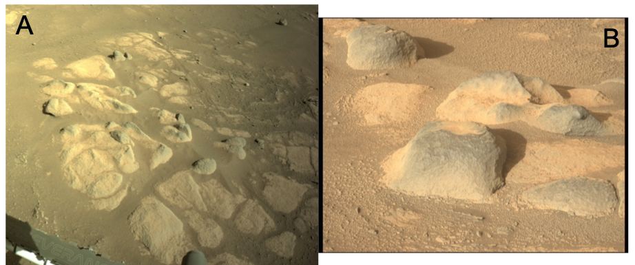
Results From the images, rocks in the workspace are presenting mainly two types of morphologies (Figure 1). Besides some float rocks, there are low-standing light-toned rocks called “pavers”, and high-standing dark-toned rocks. Pavers tend to have a more important dust cover, as they are in low-relief, compared to the high-standing rocks. The relation between the pavers and the high-standing rocks is not clear. Only a few images seem to show that the high standing rocks are directly related to the pavers, i-e that they correspond to the same material.
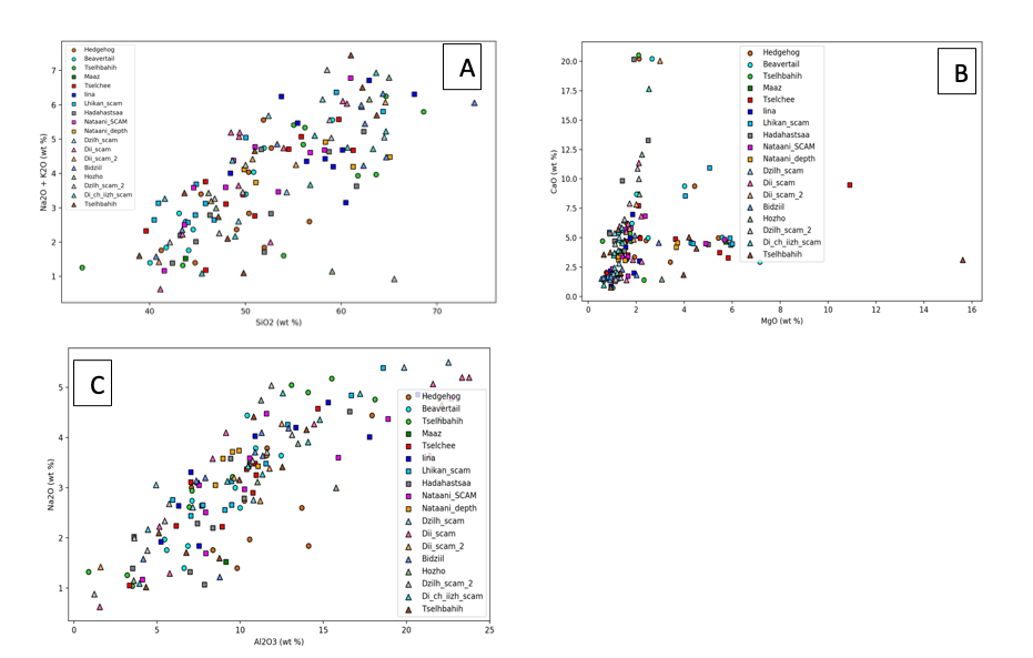
The LIBS elemental compositions are indeed essentially similar between these two types of morphologies (Figure 2). Some elements show extreme values, such as CaO, MgO and FeO, but these elevated values are observed in both morphologies and seem to be related to particular phases that have been sampled in both types of rocks.
One important observation concerns the point-to-point dispersion among each rock, whatever the rock type. This shows that the granulometry of these rocks is quite important, with grains of at least 300 microns (which is the LIBS spot size). Several grains have indeed been observed in the RMI and Watson images, consistent with this hypothesis.

Figure 1: A. NavCam image of the workspace, sol 66 (N_LRGB_0066_RAS_0032208_CYP_S_STERONVJ01); B. MastCam image showing pavers and high standing dark-toned rocks (ZCAM03130). NASA/Caltech-JPL-MSSS/ASU.

Figure 2: A. Na2O+K2O vs SiO2 content of the 19 rocks analyzed by SuperCam/LIBS. B. CaO vs MgO; C. Na2O vs Al2O3. Low standing rocks are shown as squares, High standing rocks as triangles, and float rocks as circles.
How to cite: Cousin, A., Anderson, R., Forni, O., Benzerara, K., Mangold, N., Beck, P., Dehouck, E., Ollila, A., Meslin, P.-Y., Gibbons, E., Gasnault, O., Beyssac, O., Lassue, J., Frydenvang, J., Vogt, D., Pilleri, P., Schröder, S., Clegg, S., Maurice, S., and Wiens, R.: Observations of Rocks in Jezero Landing Site: SuperCam/LIBS technique overview of results from the first six months of operations., Europlanet Science Congress 2021, online, 13–24 Sep 2021, EPSC2021-644, https://doi.org/10.5194/epsc2021-644, 2021.

