
The Formation of the Kilometer-sized Flows in Chryse Planitia (Mars)
 1,2,3,4,5,6,4,2
- 1Institute of Geophysics of the Czech Academy of Science, Prague, Czechia (petr.broz@ig.cas.cz)
- 2Faculty of Environmental Sciences, Czech University of Life Sciences Prague, Czech Republic
- 3Institute of Planetary Research, DLR, Berlin, Germany
- 4CNRS UMR-6112 LPG Nantes, France
- 5Department of Physics and Earth Sciences, Jacobs University Bremen, Germany
- 6Centre for Earth Evolution and Dynamics (CEED), University of Oslo, Norway
Introduction: High-resolution images show the presence of kilometer-sized flows (KSFs) on Mars. Most of KSFs are associated with well-known volcanic centers, hence they have been interpreted as lava flows [1,2]. However, some KSFs occur in regions where such link is not obvious and processes related to sedimentary volcanism have been proposed as an alternative [3-7]. A remarkable example of such KSF was reported by Komatsu et al. [6,8] at the southern margin of Chryse Planitia (19.16°N; 322.71°E). Later thirty-five similar KSFs (e.g., Fig. 1a) have been observed in the region [7]. KSFs typically feature three morphological elements: a) a central depression from which channel(s) originate(s), b) leveed channel(s), c) a distal portion of the fading channel where the material is deposited forming terminal lobes.
Brož et al. [7] proposed that the KSFs resulted from low viscosity mud extrusions that propagate through extensive networks of channels that gradually lose their transport energy. As initial studies were based on Context Camera (CTX) images (~5-6 m/px, [9]) and HiRISE images (~30 cm/px; [10]), they lacked topographic resolution to support these hypotheses. Currently, six KSFs are covered by HiRISE stereo pairs. Using established methods [11], we generated seven Digital Elevation Models (DEMs) with a ground sampling of 1-2 m/px to obtain additional insights about their origin.
Observations: Studied KSFs show a topographically well-defined “source” area displaying circular, semicircular or elongated map-view outline (Figs. 1, 2a). Three source areas are situated on relatively flat plains and are surrounded by ~hundred(s) of meter-wide elevated rims (Fig. 2a). The other source areas are superposed on higher elevation/inclined pre-existing surfaces with laterally less extensive rims (Fig. 1). The elevation difference between source area floors and the rims ranges from 10 to 20 m. The elevation of the source area floors is the same as that of the flat plains beyond the elevated margins on which KSFs are superposed. The margins of all studied source areas are breached, enabling any extruded fluid to flow out. The presence of elevated mounds (<10 m high), or linear ridges (e.g. Fig. 1b) was observed inside the three source areas superposed on the inclined surfaces. There are two distinct types of margin. One type is characterized by scarps several meters-high (Fig. 2a), whereas the other type has a smooth topographic transition into the surroundings, yet a distinct albedo contrast in visible data (on Fig. 2b marked as bright units).
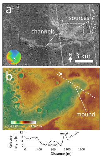
Figure 1: a) Example of studied KSF with position of HiRISE DEM marked. Base map: CTX mosaic (20.22°N and 324.06°E). b) Topography of the source area with position of the central mound and cross-profile marked (HiRISE DEM). North is up. Bottom: topographic cross profile across the source area in b.
Discussion: Our observations support the previous notions [6,7] that KSFs are aggradational, not degradational features. The inclination of the surface as well as the shape of source areas are in agreement with the suggestion that liquid material has been released from the source directly onto the pre-existing surface [7]. No signs of subsidence or explosive excavation were observed, which might be expected if these features were formed by volcanism [e.g., 12]. The mounds inside the source areas are not morphologically consistent with collapse of the rim of the source area, but could be the site where extruded material emerged at the surface and hence could mark the position of feeding conduits.
Our observations also reveal that the margins surrounding the channels are not continuous. Instead they are cut by channels joining the main channel to the bright units (Fig. 2b). No significant deposits were observed in these areas of distinct brightness, which would be expected in case of igneous eruptions (even in the case of very low viscosity lavas). This suggests that the liquid medium was capable of a dual behavior; forming elevated margins and propagating into the surroundings without displaying defined topographical boundaries at the surface.
We therefore propose a scenario that involves the release of water-rich sediments capable of both depositing onto the surface, and then spreading laterally over a wide area. During transport, levees formed on the margins of the channels. However, when the water-saturated sediments became unconfined, they spread laterally and thinned. The mixture then froze and later the ice sublimated away without leaving a detectable topographic expression, but instead changing the brightness of the surface.
Conclusions: Our study reveals that the morphology of KSFs in Chryse Planitia is consistent with the movement of low-viscosity mud across the surface during which the deposition of sediment caused the formation of leveed flow margins. The subsequent sublimation of ice removed substantial volume from the terminal parts of the flows. This supports the hypothesis proposed by [6,7] that these features are martian mud flows, formed by subsurface sediment mobilization. These features represent a window into the subsurface and an interesting target for in-situ investigation [14].
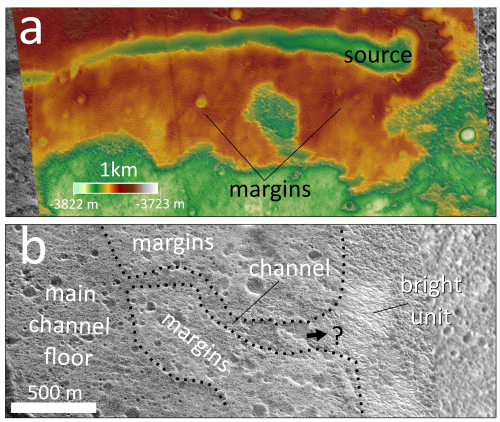
Fig. 2: Details of margins of two different KSFs in the area of interest. a) A source area superposed on relatively flat plain surrounded by km-wide margins, 19.36°N, 323.96°E (HiRISE DEM). b) Channel transitioning into a bright unit towards East (HiRISE image, 19.11°N, 322.735°E). North is up.
Acknowledgments: PB & YM were supported by Czech Science Foundation (#20-27624Y). SJC & AN are supported by the French Space Agency CNES for their HiRISE related work. AM is supported by the Research Council of Norway (#223272-288299).
References: [1] Hodges & Moore, 1994. Atlas of volcanic features on Mars. [2] Hauber et al., 2009. JVGR 185, 69-95. [3] Skinner & Tanaka, 2007. Icarus 186, 41-59. [4] Wilson & Mouginis-Mark, 2014. Icarus 233, 268-280. [5] Okubo, 2016. Icarus 269, 23-37. [6] Komatsu et al., 2016. Icarus 268, 56-75. [7] Brož et al., 2019. JGR-P 124,703-720. [8] Komatsu et al., 2011. Planet. Space Sci. 59, 169-181. [9] Malin et al., 2007. JGR 112, E05S04. [10] McEwen et al., 2007. JGR 112, E05S02. [11] Moratto et al., 2010. LPSC 41 #2364. [12] Brož & Hauber, 2013. JGR-P. 118, 1656-1675. [13] Brož et al., 2020. Nat. Geo. 13, 403-407. [14] Komatsu & Brož, LPSC2021 #1164.
How to cite: Brož, P., Hauber, E., Conway, S. J., Luzzi, E., Mazzini, A., Noblet, A., Jaroš, J., and Markonis, Y.: The Formation of the Kilometer-sized Flows in Chryse Planitia (Mars), Europlanet Science Congress 2021, online, 13–24 Sep 2021, EPSC2021-77, https://doi.org/10.5194/epsc2021-77, 2021.