
Deciphering the deformation history of Ulysses Fossae, Mars, using fault pattern analysis
 1,1,2,1
- 1School of Earth and Environment, University of Leeds, Leeds, United Kingdom
- 2Marine, Earth, and Atmospheric Sciences, North Carolina State University, Raleigh, USA
Abstract
We mapped and analyzed the morphology and strike of a large population of faults observed in Ulysses Fossae, Mars, to determine the sequence and character of deformation in the area. Preliminary results based on distinct fault populations suggest a structural history of Ulysses Fossae featuring activity at several different volcanic centers, regional extension, and later reactivation of older fault populations.
1. Introduction
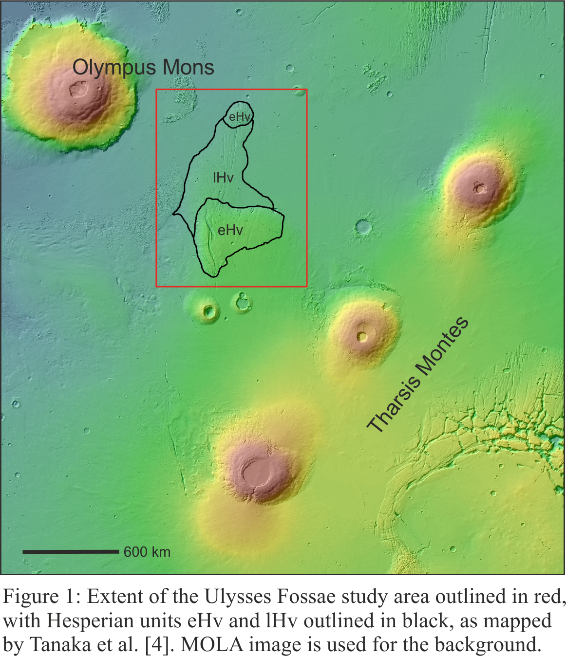
The heavily faulted terrain of Ulysses Fossae lies at 10°N, 123°W, amongst the volcanoes of the Tharsis Rise (Figure 1). Olympus Mons is situated ~800 km to the west, the Tharsis Montes to the east, and the Ulysses Patera volcano immediately to the south. Ulysses Fossae has been the target of only a few dedicated studies [e.g., 1, 2], but is a distinct location in that it displays faults which appear radial to Olympus Mons. Further investigation of this area is therefore expected to help illuminate the complex volcano-tectonic history of the Olympus Mons volcano and the Tharsis volcanic province more generally.
2. Methods
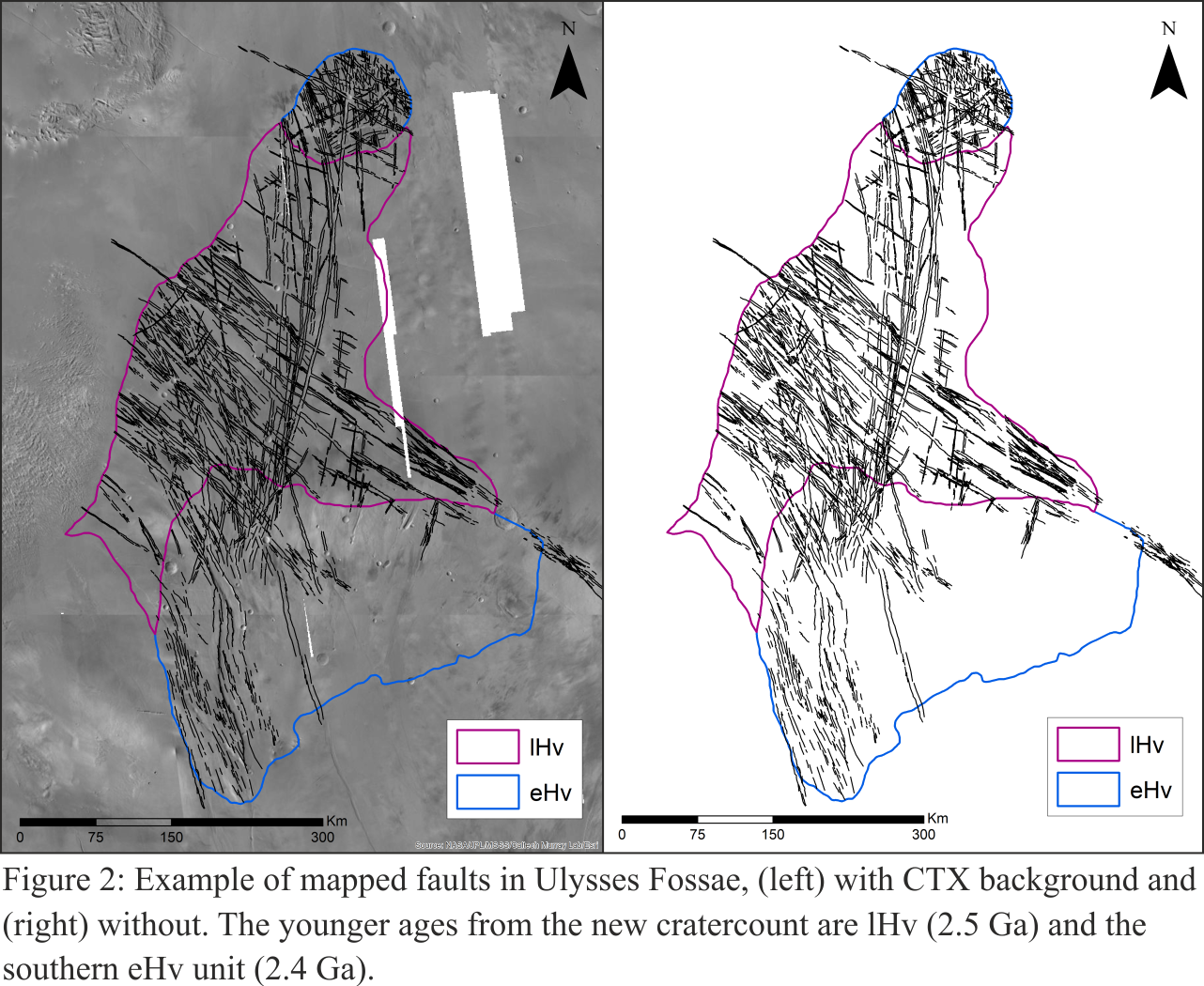
We used Context Camera (CTX) images, with a resolution of 6 m/pixel [3], to map all the faults in the Ulysses Fossae study site at a scale of ~1:250,000; mapping from Tanaka et al. [4] providing outlines for the three Hesperian geological units in the study area. Mars Orbiter Laser Altimeter (MOLA) data were used to create topographic profiles of select areas in Ulysses Fossae. The MOLA data was complemented by images from the High-Resolution Stereo Camera (HRSC), creating a Digital Elevation Model (DEM) with a resolution of 200 m/px [5]. Crater statistics derived from these three units with the “Cratertools” ArcMap tool and the Craterstats v.2 program [6, 7] were used to calculate absolute model ages.
3. Preliminary Results and Discussion
In total, we mapped 5,165 faults in Ulysses Fossae (Figure 2), with fault patterns ranging from linear to curved. Detailed analysis of the mapped faults, including investigating cross-cutting relationships, morphology, and azimuths, allowed us to divide the faults to into eight main fault populations (see Table 1). On the basis of strike, the majority of these populations reflect influence from local volcanic centers, as they display radial fault patterns to Olympus Mons, Pavonis Mons, and Ulysses Patera. One of the older populations, Population 2 (Table 1), dated to be Early Hesperian, appears to solely be the result of regional extension associated with the growth of Tharsis. The youngest fault population, Population 7, from the late Hesperian, consists of slightly curved grabens with a sigmoidal geometry and en echelon patterns, and appears to have formed by reactivation of the two oldest mapped fault populations.
Additionally, we acquired crater statistics for the geological units in the study area to calculate absolute model ages to aid in our understanding of the geological history of Ulysses Fossae. This analysis resulted in giving two of the units a potentially significantly younger, Amazonian age, than previously determined [4] see Fig. 2.

4. Summary and Conclusions
Our mapping resulted in the recognition and analysis of eight fault populations, which together suggest several stages of structural activity in the Ulysses Fossae region. Results from relative and absolute model age analysis so far indicate a complex history involving radial fault growth from the several surrounding proximal volcanoes (Olympus Mons, Pavonis Mons, and Ulysses Patera), later reactivation of pre-existing fault populations and some influence from the regional extension of the Tharsis rise.
Further investigations based on this initial work will include measuring extensional strain for the eight fault populations, and maximum displacement/length (Dmax/L) relationships for select study faults, with the data ultimately being intended to help in comparisons to other volcanic areas on Mars and other terrestrial planets.
Acknowledgements
To NASA for providing CTX and MOLA data, and ESA for HRSC data. Funding for this project was provided by the UK Research and Innovation (UKRI) Natural Environment Research Council’s (NERC) Doctoral Training Programme.
References
[1] Scott, D. H., & Dohm, J. M. (1990). Faults and ridges—Historical development in Tempe Terra and Ulysses Patera regions of Mars. Proceedings of the Lunar and Planetary Science Conference, 20, 503–513
[2] Fernández, C., & Ramírez-Caballero, I. (2019). Evaluating transtension on Mars: The case of Ulysses Fossae, Tharsis. Journal of Structural Geology, 125, 325–333.
[3] Malin, M, et al. 2007. Context Camera Investigation on board the Mars Reconnaissance Orbiter. Journal of Geophysical Research. 2007, Vol. 112.
[4] Tanaka, K. L., Skinner Jr., J. A., Dohm, J. M., Irwin, III, R. P., Kolb, E. J., Fortezzo, C. M., Platz, T., Michael, G. G., & Hare, T. M. (2014). Geologic Map of Mars (Scientific Investigations Map)
[5] Fergason, R. L., Hare, T. M., & Laura, J. (2018). HRSC and MOLA Blended Digital Elevation Model at 200m v2. [Map]. Astrogeology PDS Annex, U.S. Geological Survey.
[6] Michael, G.G. 2013. Planetary surface dating from crater size–frequency distribution measurements: Multiple resurfacing episodes and differential isochron fitting. Icarus. 2013
[7] Michael, G. G and Neukum, G. 2010. Planetary surface dating from crater size–frequency distribution measurements: Partial resurfacing events and statistical age uncertainty. Earth and Planetary Science Letters. 2010.
[8] Hartmann, W. K., & Daubar, I. J. (2016). Martian cratering 11. Utilizing decameter scale crater populations to study Martian history. Meteoritics & Planetary Science, 52, 493–510. https://doi.org/10.1111/maps.12807
[9] Michael, G. G., Kneissl, T., & Neesermann, A. (2016). Planetary surface dating from crater size‐frequency distribution measurements: Poisson timing analysis. Icarus, 277, 279–285. https://doi.org/10.1016/j.icarus.2016.05.019
How to cite: Shahrzad, S., Bramham, E., Thomas, M., Byrne, P. K., Mortimer, E., and Piazolo, S.: Deciphering the deformation history of Ulysses Fossae, Mars, using fault pattern analysis, European Planetary Science Congress 2021, online, 13–24 Sep 2021, EPSC2021-782, https://doi.org/10.5194/epsc2021-782, 2021.