
The Claritas Fossae region, an example of polyphasic deformation on Mars?
 1,1,1,
- 1Università degli Studi di Genova, Dipartimento di Scienze della Terra dell'Ambiente e della Vita (DISTAV), Corso Europa, 26, 16132, Genova, Italy
- 2Università degli Studi di Genova, Dipartimento di Fisica (DIFI), Via Dodecaneso, 33, 16146, Genova, Italy
The Claritas Fossae (CF) is a Martian system of scarps and troughs with NNE-SSE elongation that exceeds 1000 km of length and 150 km of width. It develops mainly in Late to Middle Noachian highland units and Hesperian lava flows (Tanaka et al., 2014). It is bounded to the east by the elevated plateau of Syria Planum, Sinai Planum and Solis Planum mostly consisting in late Hesperian volcanic units; and to the west by the relatively topographically lower Daedalia Planum made of the Amazonian-Hesperian volcanic lava flows of Tharsis (Fig 1a).
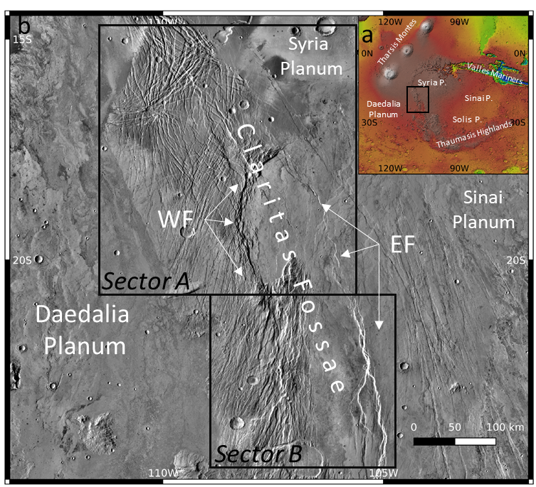
Figure 1 a) Location of the study area. b) The study area with its subdivision in the two Sectors A and B and the location of the Western Fault (WF) and the Eastern Fault (EF).
In this study, we focus on the northernmost part of the CF (Fig 1b) that can be subdivided in two different sectors (Hauber & Kronberg, 2005) on the basis of the characteristics of the main scarps and the valley floor:
- Sector A: It is characterised to the north and to the west by a topographically high area etched by numerous depressions up to tens of km long with different orientations, and to the south-east by an asymmetric valley. This valley is bounded to the west by an abrupt scarp, dipping to the east, that exceeds 200 km of length and presents up to 1000 m of elevation change. The eastern slope of the valley is represented by the northernmost part of a scarp here characterised by a maximum elevation change of 300 m and WSW dipping. These steep morphologies suggest a strong tectonic control; the faults responsible for their evolution are hereinafter referred to as the Western Fault (WF) and the Eastern Fault (EF), respectively.
- Sector B: The western slope of the asymmetric valley is gentler and with lower topographic contrast compared to Sector A lacking the topographic evidence of the WF. On the other side, the southward continuation of the EF presenting topographic changes up to 2000 m describes a steep scarp that strongly suggests its tectonic control.
The aim of this study is to reconstruct the tectonic processes that affected this area in order to gather a better comprehension of the tectonic style(s) that Mars experienced. In this perspective, a multi-scalar approach is of outmost importance. To do so, we conducted two types of analysis:
- Structural mapping of the regionally sized faults and fault-related fractures in Sectors A and B (still ongoing);
- Forward modelling aimed at reproducing the development in depth of the EF in Sector B.
For the structural mapping, we analyse satellite images that were processed to enhance the detectability of tectonic structures. The dataset we used, with different spatial resolution, includes: a) the topographic map of Mars from the Mars Orbiter Laser Altimeter (MOLA DEM and relative colour shade, 200 mppx); b) the Thermal Emission Imaging System dataset that shows the thermo-physical properties of the outcropping lithologies with InfraRed Day and Night acquisitions (THEMIS IRDay/Night, 100 mppx); and c) the Mars Reconnaissance Orbiter Context Camera mosaic (MRO-CTX, 6 mppx), used to explore the crosscutting relationships between the mapped structures. In addition, to better highlight the tectonic structures and to avoid limits and bias related to the use of a single lighting direction (Wise et al., 1985), we produced four shadowed images according to four synthetic lightening conditions (0°, 45°, 90°, 135°).
For the modelling of the EF, we consider the regional scale topography of the Martian surface as a reference layer reflecting the crustal tectonic processes. In fact, the erosional processes on Mars have very low rates, and have a negligilble effect in shaping the regional physiography (Klimczak et al., 2018). We used the HCA method (Salvini & Storti, 2004) aimed at reproducing the superficial morphologies by studying the movement of two crustal blocks separated by a fault with a given geometry. We modelled the topography derived from four topographic profiles trending perpendicular to the EF; results show that the activity of a crustal, listric normal fault replicates the topography across the CF. This crustal normal fault reaches the base of the crust at 80 km of depth, a value in accordance with literature (Watters et al., 2007). The dip of the fault decreases from about 60 degrees near the surface to about 20 degrees at the boundary between crust and mantle. The fault displacement varies from north to south, reaching a maximum of 2000 m.
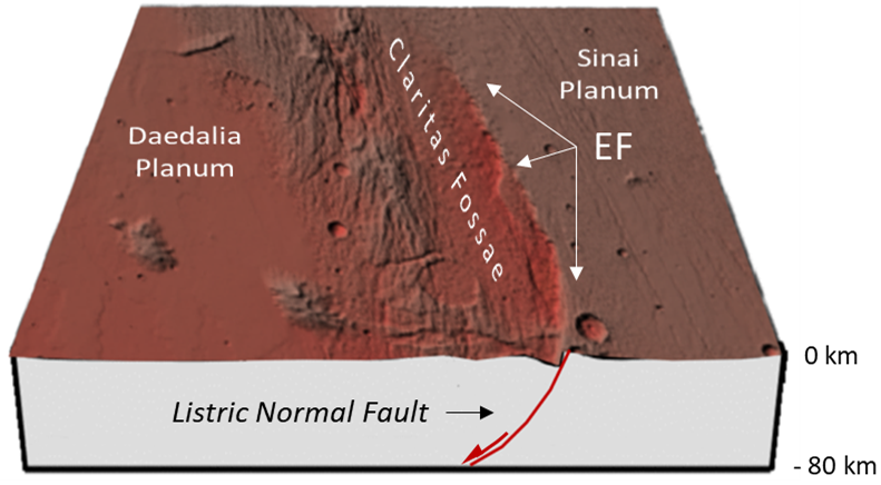
Fig. 2 – Sketch of the modelled listric normal EF
The preliminary results of the structural mapping show that the identified tectonic structures are not randomly distributed. The statistical analysis by frequency distribution of the mapped tectonic structures shows their clustering in four main azimuthal families: i) NNE-SSW; ii) NNW-SSE; iii) ENE-WSW; and iv) WNW-ESE. By analyzing the crosscutting relationships among the mapped structures and the relative ages of the terrains where they develop, we recognized multiple deformation events at different scale, both regional and hemispheric. Furthermore, by comparing the main trend of the found azimuthal families with the expected direction of the structures in a strike-slip regime (Li et al., 2016), we found correspondence with a right lateral strike-slip regime oriented NNW-SSE, similarly to the main scarps of the CF. The ongoing structural mapping and the spatial-azimuthal analysis of the family set will allow us to better constrain the relative chronology of deformation events and to produce a tectonic evolutionary model of the studied region.
These preliminary results suggest that the investigated area has been interested by a long-lasting tectonic deformation history made of multiple reactivations of crustal weakness zones. The structural setting of the area is likely related to the contribution of several factors acting also at different scales. At the hemispheric scale we recognized deformations associated to the development/evolution of Tharsis Bulge and of the Tharsis Montes; at the regional scale we recognized tectonic structures related to the evolution of the CF where evidence of strike slip and extensional deformations have been recognized.
How to cite: Balbi, E., Cianfarra, P., Ferretti, G., Crispini, L., and Tosi, S.: The Claritas Fossae region, an example of polyphasic deformation on Mars?, Europlanet Science Congress 2022, Granada, Spain, 18–23 Sep 2022, EPSC2022-1041, https://doi.org/10.5194/epsc2022-1041, 2022.