Europlanet Science Congress 2022
Palacio de Congresos de Granada, Spain
18 – 23 September 2022
Europlanet Science Congress 2022
Palacio de Congresos de Granada, Spain
18 September – 23 September 2022
TP11
Structural Geology and Deformational Histories of Terrestrial Bodies

TP11

This session welcomes contributions involving the analysis of structural features and deformational histories on Mars, Mercury, The Moon and Venus. The use of structural analysis in various aspects of planetary science is a powerful addition to geological interpretation that can often go underappreciated. Abstracts might include the duality of mantle processes and fluid movement (both past and present) and their relationship to observed faults, folds, graben, wrinkle wridges, chasmata and volcanoes, as well as concepts involving radar sub-surface/surface imaging, fault displacement, stress fields, bedding attitude and deposit geometry. We encourage studies that involve the Oxia Planum ExoMars landing site (e.g. structural analysis and integrity), InSight, SHARAD (e.g. sub-surface imaging of the polar layer deposits) and the future of mapping surface deformation on Venus with the addition of VERITAS. We also encourage reviews and comparisons of structural features between planets, particularly in ways that better constrain the application/terminology of Earth processes (e.g. proto-plate vs. plate tectonics) when interpreting features on other planets.

Convener: Gene Schmidt | Co-convener: Trishit Ruj
Orals
| Thu, 22 Sep, 15:30–18:10 (CEST)|Room Machado
Posters
| Attendance Thu, 22 Sep, 18:45–20:15 (CEST) | Display Wed, 21 Sep, 14:00–Fri, 23 Sep, 16:00|Poster area Level 1

Session assets

Discussion on Slack

Orals: Thu, 22 Sep | Room Machado

Chairpersons: Gene Schmidt, Trishit Ruj
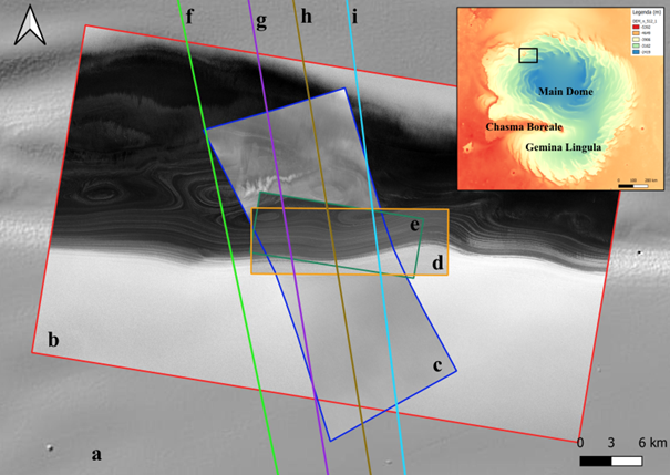
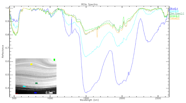
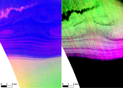
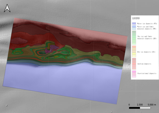
15:30–15:31
15:31–15:41
|
EPSC2022-699
|
ECP
Structural Style and Origin Of Western Jokwa Linea Groove Belt, Se Stanton Quadrangle (V-38), Venus
(withdrawn)
Rachid Oukhro, Hafida El Bilali, Richard Ernst, James Head, and Nasrrddine Youbi
15:41–15:51
|
EPSC2022-1041
|
ECP
Evandro Balbi, Paola Cianfarra, Gabriele Ferretti, Laura Crispini, and Silvano Tosi

The Claritas Fossae (CF) is a Martian system of scarps and troughs with NNE-SSE elongation that exceeds 1000 km of length and 150 km of width. It develops mainly in Late to Middle Noachian highland units and Hesperian lava flows (Tanaka et al., 2014). It is bounded to the east by the elevated plateau of Syria Planum, Sinai Planum and Solis Planum mostly consisting in late Hesperian volcanic units; and to the west by the relatively topographically lower Daedalia Planum made of the Amazonian-Hesperian volcanic lava flows of Tharsis (Fig 1a).

Figure 1 a) Location of the study area. b) The study area with its subdivision in the two Sectors A and B and the location of the Western Fault (WF) and the Eastern Fault (EF).

In this study, we focus on the northernmost part of the CF (Fig 1b) that can be subdivided in two different sectors (Hauber & Kronberg, 2005) on the basis of the characteristics of the main scarps and the valley floor:

  • Sector A: It is characterised to the north and to the west by a topographically high area etched by numerous depressions up to tens of km long with different orientations, and to the south-east by an asymmetric valley. This valley is bounded to the west by an abrupt scarp, dipping to the east, that exceeds 200 km of length and presents up to 1000 m of elevation change. The eastern slope of the valley is represented by the northernmost part of a scarp here characterised by a maximum elevation change of 300 m and WSW dipping. These steep morphologies suggest a strong tectonic control; the faults responsible for their evolution are hereinafter referred to as the Western Fault (WF) and the Eastern Fault (EF), respectively.
  • Sector B: The western slope of the asymmetric valley is gentler and with lower topographic contrast compared to Sector A lacking the topographic evidence of the WF. On the other side, the southward continuation of the EF presenting topographic changes up to 2000 m describes a steep scarp that strongly suggests its tectonic control.

The aim of this study is to reconstruct the tectonic processes that affected this area in order to gather a better comprehension of the tectonic style(s) that Mars experienced. In this perspective, a multi-scalar approach is of outmost importance. To do so, we conducted two types of analysis:

  • Structural mapping of the regionally sized faults and fault-related fractures in Sectors A and B (still ongoing);
  • Forward modelling aimed at reproducing the development in depth of the EF in Sector B.

For the structural mapping, we analyse satellite images that were processed to enhance the detectability of tectonic structures. The dataset we used, with different spatial resolution, includes: a) the topographic map of Mars from the Mars Orbiter Laser Altimeter (MOLA DEM and relative colour shade, 200 mppx); b) the Thermal Emission Imaging System dataset that shows the thermo-physical properties of the outcropping lithologies with InfraRed Day and Night acquisitions (THEMIS IRDay/Night, 100 mppx); and c) the Mars Reconnaissance Orbiter Context Camera mosaic (MRO-CTX, 6 mppx), used to explore the crosscutting relationships between the mapped structures. In addition, to better highlight the tectonic structures and to avoid limits and bias related to the use of a single lighting direction (Wise et al., 1985), we produced four shadowed images according to four synthetic lightening conditions (0°, 45°, 90°, 135°).

For the modelling of the EF, we consider the regional scale topography of the Martian surface as a reference layer reflecting the crustal tectonic processes. In fact, the erosional processes on Mars have very low rates, and have a negligilble effect in shaping the regional physiography (Klimczak et al., 2018). We used the HCA method (Salvini & Storti, 2004) aimed at reproducing the superficial morphologies by studying the movement of two crustal blocks separated by a fault with a given geometry. We modelled the topography derived from four topographic profiles trending perpendicular to the EF; results show that the activity of a crustal, listric normal fault replicates the topography across the CF.  This crustal  normal fault reaches the base of the crust at 80 km of depth, a value in accordance with literature (Watters et al., 2007). The dip of the fault decreases from about 60 degrees near the surface to about 20 degrees at the boundary between crust and mantle. The fault displacement varies from north to south, reaching a maximum of 2000 m.

Fig. 2 – Sketch of the modelled listric normal EF

The preliminary results of the structural mapping show that the identified tectonic structures are not randomly distributed. The statistical analysis by frequency distribution of the mapped tectonic structures shows their clustering in four main azimuthal families: i) NNE-SSW; ii) NNW-SSE; iii) ENE-WSW; and iv) WNW-ESE. By analyzing the crosscutting relationships among the mapped structures and the relative ages of the terrains where they develop, we recognized multiple deformation events at different scale, both regional and hemispheric. Furthermore, by comparing the main trend of the found azimuthal families with the expected direction of the structures in a strike-slip regime (Li et al., 2016), we found correspondence with a right lateral strike-slip regime oriented NNW-SSE, similarly to the main scarps of the CF. The ongoing structural mapping and the spatial-azimuthal analysis of the family set will allow us to better constrain the relative chronology of deformation events and to produce a tectonic evolutionary model of the studied region.

These preliminary results suggest that the investigated area has been interested by a long-lasting tectonic deformation history made of multiple reactivations of crustal weakness zones. The structural setting of the area is likely related to the contribution of several factors acting also at different scales. At the hemispheric scale we recognized deformations associated to the development/evolution of Tharsis Bulge and of the Tharsis Montes; at the regional scale we recognized tectonic structures related to the evolution of the CF where evidence of strike slip and extensional deformations have been recognized.

How to cite: Balbi, E., Cianfarra, P., Ferretti, G., Crispini, L., and Tosi, S.: The Claritas Fossae region, an example of polyphasic deformation on Mars?, Europlanet Science Congress 2022, Granada, Spain, 18–23 Sep 2022, EPSC2022-1041, https://doi.org/10.5194/epsc2022-1041, 2022.

15:51–16:01
|
EPSC2022-903
|
ECP
Geological History of Nott Corona, Isabella Quadrangle (V-50), Venus
(withdrawn)
Ismail Hadimi, Hafida El bilali, Richard Ernst, and Nasrrddine youbi
16:01–16:11
|
EPSC2022-965
|
ECP
Geological History Of Maram Corona And Link With Host Parga Chasmata, Venus  
(withdrawn)
Kamal Mghazli, Hafida El Bilali, Richard Ernst, and Nasrrddine Youbi
16:11–16:21
|
EPSC2022-872
|
ECP
Sam Poppe, Alexandra Morand, Claire Harnett, Marek Awdankiewicz, Anne Cornillon, Michael Heap, and Daniel Mège

Surface deformation patterns on terrestrial planetary bodies have been interpreted as magma emplacement features due to their similarity with Earth analogues or their association with inferred eruptive products. Dome-shaped surface uplift features were recognized for example at floor-fractured impact craters on the Moon (Jozwiak et al., 2012), and at the Tharsis volcanic province on Mars (Farrand et al., 2011). The lack of subsurface geophysical data however precludes a clear observation of the characteristics and emplacement mechanisms of the inferred underlying magma intrusions.

On Earth, our insight into the characteristics of the magmatic plumbing systems that underly surface doming also remains cryptic due to the sparsity of observations. The most recent event was the hybrid explosive-effusive eruption at Cordón Caulle, Chile, in 2011. Pre- and syn-eruptive surface doming and pervasive ground fracturing observed there using satellite radar interferometry was interpreted there to result from the intrusion of a rhyolitic laccolith (Castro et al., 2016). Analytical and numerical models can use such geodetic observations to help estimate intrusion characteristics and assist in forecasting potential volcanic eruptions. The same models are used to infer shallow magma intrusion characteristics on terrestrial planetary bodies where the only observations available are surface topography and shallow ground-penetrating radar data.

Existing models generally assume that planetary crusts deform linearly-elastic, which leads to a simplification of the magmatic source geometry and the related displacement and stress fields. On Earth, however, host rocks around exposed solidified and exposed dykes, sills and laccoliths often show indicators of non-elastic deformation. Strain can accumulate along large-scale discontinuities in the overburden rocks, making the investigation of the emplacement mechanisms by traditional continuum models difficult.

To provide a more geologically realistic means of estimating magma intrusion characteristics and investigate the associated emplacement mechanisms, we have developed a numerical discontinuum model of laccolith emplacement within the framework of the “DeMo-Planet” project. We use the two-dimensional (2D) Discrete Element Method (DEM) model PFC2D (Itasca Consulting Group, Inc.) to represent the modelled medium as a particle-based network. We can use this model to indicate fracturing and highly discontinuous deformation, as well as visualizing the localization of subsurface strain and corresponding deformation.

Two stages of the model application are now available. In a first stage, a laccolith-shaped pressure source is inflated at the base of the host medium with varied depth of the magmatic source. In a second stage, particles are injected into the laccolith-shaped fluid body to simulate constant magma supply into a growing intrusion.

In this presentation, we will simulate laboratory tests to calibrate the mechanical behaviour and the relations between particle contact parameters of the numerical host rock and magma. To that end, we use the elastic property values (Young modulus) and tensile strength measured on host rocks estimated for the Moon and Mars (Heap et al., 2020). We then use elastic properties measured using uni-axial laboratory tests. The investigated rock samples were collected from exposed Permian sediments above Permian trachyandesite intrusions of the Intra-Sudetic Synclinorium in Poland. The calibration of the model with geological data then allows a comparison of the numerical results with field observations of the structural deformation in the intrusions’ overburden. In the future, we plan to analyze the effect of varying gravity, geometric and mechanical model parameters on the ratio of tensile to shear-mode fracturing, as well as investigating the magma-induced surface displacement in detail.

DeMo-Planet demonstrates a promising multidisciplinary approach of informing numerical models of complex, discontinuous magma emplacement processes in the heterogeneous and fractured shallow crust of terrestrial planetary bodies. The validation of this new modelling application with detailed structural information from representative Earth analogue sites will allow us to investigate the characteristics of the cryptic magma bodies underlying surface doming on the Moon and Mars. The application of our model to other terrestrial planetary bodies will simultaneously improve the interpretation of volcanic unrest signals on Earth.

References

Castro, J.M. et al. (2016) “Rapid laccolith intrusion driven by explosive volcanic eruption,” Nature Communications, 7, p. 13585. doi:10.1038/ncomms13585.

Farrand, W.H. et al. (2011) “Spectral evidence of volcanic cryptodomes on the northern plains of Mars,” Icarus, 211(1), pp. 139–156. doi:10.1016/j.icarus.2010.09.006.

Heap, M.J. et al. (2020) “Towards more realistic values of elastic moduli for volcano modelling,” Journal of Volcanology and Geothermal Research, 390, p. 106684. doi:10.1016/j.jvolgeores.2019.106684.

Jozwiak, L.M. et al. (2012) “Lunar floor-fractured craters: Classification, distribution, origin and implications for magmatism and shallow crustal structure,” Journal of Geophysical Research E: Planets, 117(11), pp. 1–23. doi:10.1029/2012JE004134.

How to cite: Poppe, S., Morand, A., Harnett, C., Awdankiewicz, M., Cornillon, A., Heap, M., and Mège, D.: Discontinuum modelling of magma emplacement below surface doming on the Moon, Mars and Earth analogues from the Polish Sudetes, Europlanet Science Congress 2022, Granada, Spain, 18–23 Sep 2022, EPSC2022-872, https://doi.org/10.5194/epsc2022-872, 2022.

16:21–16:31
|
EPSC2022-556
Sam Rivas-Dorado, Javier Ruiz Perez, and Ignacio Romeo Briones

Introduction

We modeled the sequence of discontinuities forming in the subsurface due to dike intrusion with the objective of understanding the possible mechanisms of dike-induced graben nucleation. We did this at three sites in the Elysium Mons region of Mars: Galaxias Fossae (GF), Elysium Fossae (EF) and Cerberus Fossae (CF). From our results we propose to general models of graben nucleation above dikes under Martian conditions.

Methodology

Firstly, we used cross-section area balancing on MOLA topographic profiles across one graben in each site to obtain approximations of dike geometry, mainly, aperture (a) and top-dike depth (Dd) (Rivas-Dorado et al., 2020). Because these parameters are sensitive to fault angle, for each location we used three values: 55, 60 and 65º. Then, for each of these we used three sets of mechanical properties, corresponding to a weak, intermediate, and strong host rock, as inputs for the dynamic models. In each model, driving stress is increased step wise and at each step the following processes take place. First, the composite dike-induced stress field is calculated considering both the dike’s driving stress and the lithostatic load (Pollard and Segall, 1987). Then, the principal stresses ( and ) are calculated from the total dike-induced stresses. Finally,  and  are used in the modified Griffith failure criterion to determine which points in the grid are at failure, and if this is the case, their mode and orientation. At the end of the model, a sequence of discontinuities forming between the dike tip and the surface has been recorded. This methodology was applied to all three sites, which resulted in 27 models.

Results

14 models were found to be compatible with the nucleation of dike-induced faults, from which we propose two general models. We define compatible models as those in which the discontinuities form through a sequence, and at an orientation and location, which are compatible with the inferred present-day faults.

The first generic model corresponds to narrow and relatively shallow dikes emplaced in a low-compliance host rock (Fig. 1a). In this case, fault nucleation occurs through the coeval propagation of mode-I tensile cracks from the surface to depth, and of mode-II discontinuities formed under general compression or tension-compression, from the dike tip to the surface. In this scenario, the dike driving stresses are relatively small and tension cracks dominate over 50-65 % Dd. The second model corresponds to wider and deeper dikes emplaced in a higher-compliance host rock (Fig 1b). In this scenario, fault nucleation occurs through the propagation of near-surface mode-I cracks to depth, and mixed-mode I-II plus mode-I discontinuities from the dike tip to the surface, which lead to the formation of high-angle faults. The required dike driving stresses in these models are larger, and the section between the dike tip and the surface is dominated by tensile structures, which occupy >65% Dd.

We also ran equivalent models under Martian versus terrestrial conditions to explore the differences in the style of growth of the discontinuities. We found that under terrestrial conditions the extent of the tension-dominated section is narrower and restricted to the near surface, <20% Dd, and that fault nucleation requires a larger participation of mode-II discontinuities. This is because of the greater contribution of the lithostatic stresses which, in general, make tensile failure at depth more difficult.

The results of our models are consistent with several numerical and analogue models, and with multitude of observations. For example, mapping of the displacements along dike-induced graben in the Exmouth plateau, through high-resolution 3D seismic, frequently reveals two points of maximum slip along many faults. This indicates that these have grown from two nucleation points, one shallower and one deeper, as proposed in both our generic models (Magee and Jackson, 2020, 2021). Although comparisons with terrestrial models and observations must be made with caution, since they respond to dike emplacement under different pre-diking conditions, the observed similarities support our model results.

Conclusions

We performed several dynamic models of the discontinuities formed during the emplacement of dikes under different conditions, at three locations in the Elysium Mons region of Mars. From these we propose two generic models of dike-induced graben nucleation: 1) shallow, narrower dikes emplaced in a weaker host rock in which both tensile cracks and faults participate in fault nucleation, and 2) deeper, wider dikes emplaced in a stronger host rock, which generate faults in a dominantly tensile regime. These results can be reconciled with models of dike-induced deformation, and with observations in real case studies. However, our models only address the question of early fault nucleation. Further research and modelling efforts are required to understand later dike-induced graben development and the processes associated with it, such as long-term post-diking seismicity. This may be key to understand the origin of the marsquakes currently being detected by InSight in the Elysium region, and specifically, in the vicinity of Cerberus Fossae.

We constructed dynamic models of the fractures and faults formed around an intruding dike by considering both the dike and lithostatic stresses. From these we propose two distinct conceptual models of graben nucleation with different participation of faults and fractures; one in which shallower and narrower dikes nucleate graben through both faults and tensile cracks, another in which deeper and wider dikes generate graben mostly through the linkage of mode-I fractures. 

References

Magee, C., Jackson, C., 2020. Seismic reflection data reveal the 3D structure of the newly discovered Exmouth Dyke Swarm, offshore NW Australia. Solid Earth 11, 579–606. https://doi.org/10.5194/se-11-579-2020

Magee, C., Jackson, C.A.L., 2021. Can we relate the surface expression of dike-induced normal faults to subsurface dike geometry? Geology 49, 366–371. https://doi.org/10.1130/G48171.1

Pollard, D.D., Segall, P., 1987. Theoretical displacements and stresses near fractures in rock: with applications to faults joints, veins, dikes and solution surfaces, Fracture Mechanics of Rock. Academic Press Inc., London. https://doi.org/https://doi.org/10.1016/B978-0-12-066266-1.50013-2

Rivas-Dorado, S., Ruiz, J., Romeo, I., 2020. Subsurface Geometry and Emplacement Conditions of a Giant Dike System in Elysium Fossae, Mars. J. Geophys. Res. Planets n/a, 2020JE006512. https://doi.org/https://doi.org/10.1029/2020JE006512

How to cite: Rivas-Dorado, S., Ruiz Perez, J., and Romeo Briones, I.: Two mechanisms of graben nucleation above dikes based on elastic and frictional models applied at three locations in the Elysium Rise, Mars, Europlanet Science Congress 2022, Granada, Spain, 18–23 Sep 2022, EPSC2022-556, https://doi.org/10.5194/epsc2022-556, 2022.

16:31–16:41
|
EPSC2022-998
|
ECP
Geological History of Lava flows and Graben Systems (Dyke Swarms) Of The Mbokomu Mons Region, Along Parga Chasmata, 2400 Km SE Of Atla Regio, Venus.
(withdrawn)
Naima Hannour, Hafida El Bilali, Richard .E Ernst, James .W Head, and Nasseriddine Youbi
16:41–16:51
|
EPSC2022-382
|
ECP
Devanshi Kacholia, Wim H. Bakker, and Hossein Aghababaei

INTRODUCTION

In recent years, the Martian world has drawn the attention of researchers all over the globe. Mars’ rich geological record and fascinating history led scientists and space organisations to be keen on studying the planet more closely. Several studies on Mars are primarily focused on determining the potential for life. (Nazari-Sharabian et al., 2020). The similarities between Mars and early Earth are a big part of why people want to study it. Little has changed on Mars since the Hesperian epoch, 2.9 billion years ago, due to the lack of plate tectonics (Victoria et al., 2018). As a result, unlike Earth, it is possible to look at Mars as a blank canvas due to no artificial structural advancements. The discovery of geological features that resemble small valleys and river plains (Rice et al., 2008) has only raised the possibilities of finding water on Mars in some form. Many dramatic events occurred on Mars' glacial past, leading to the construction of valleys, river plains, glacial landforms, and other features. We have recently learned a lot more about such features.

Mars’ extreme glacial history led to significant changes and the formation of interesting features such as glacial-like landforms on the planet. Changes in the orbital and rotational parameters have allowed ice from ice-rich polar regions to shift towards the equator (Mischna et al., 2003). This process is termed mid-latitude glaciation (Hepburn et al., 2020; Milliken et al., 2003). Furthermore, these formations have flow-like geomorphology as shown in figure 1, indicating the presence of ice underneath these landforms  (Holt et al., 2008; Souness et al., 2012). Examining the depths of these GLFs may yield information on the events that have manifested in significant geographical and climatic changes.