
Morphometry of an hexagonal pit crater in Pavonis Mons, Mars
 1,1
1,1- 1Jacobs University Bremen, Department of Physics and Earth Sciences, Bremen, Germany (g.nodjoumi@jacobs-university.de)
- 2Department of Geosciences, University of Padova, Padova, Italy
- 3Department of Biological, Geological and Environmental Sciences, University of Bologna, Bologna, Italy
Introduction:
Pit craters are peculiar depressions found in almost every terrestrial body of the Solar System [1]–[4]. Morphologically characterized by circular to elliptical shapes, flat rim and no ejecta blankets. Often found aligned to form a pit chain, or even coalesced with other pits. Depending on their morphology and type of alignemt (e.g. sinuous or straight in presence of faults) their origin may be attributed to either tectonic or to the collapse of a lava tube [2]. On the other hand, atypical pit craters can be found isolated with no major additional surface morphological expressions. In this work, we present a morphometric analysis of one of the atypical pit craters found on the flank of Pavonis Mons. The pit central coordinates are Lon -110.80 Lat 0.33
Data:
We used a single stereo pair, ESP_033935_1805 - ESP_041900_1805, acquired by the High Resolution and Imaging Science Experiment (HiRISE) [5]and downloaded from NASA ODE-PDS [6].
Morphometric analysis:
We created a high-resolution Digital Elevation Model (DEM) with a spatial resolution of 0.5 m/pixel, using a custom Jupyter Lab environment [7] to process the data with the Integrated Software for Imagers and Spectrometers (ISIS) [8] and the Ames Stereo Pipeline [9]. Finally, using QGIS v3.24, we performed the morphometric analysis, summarized in Table 1.
Within QGIS, we digitised the shape of the pit, contouring the rim on the orthoimage, where is clearly recognizible the extension of the pit, as shown in Figure 1.
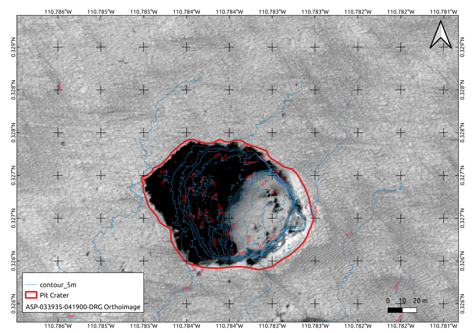
Figure 1. In red, the polygon of the pit, designed over the orthoimage.
Then we measured the semi-axis of the ellipse inscribing the shape of the pit and, finally, we used the plugin Volume Calculation Tool to compute the volume of the pit. We also computed elevation contour lines at 2 m interval. Figure 2 shows graphically the results of the analysis.
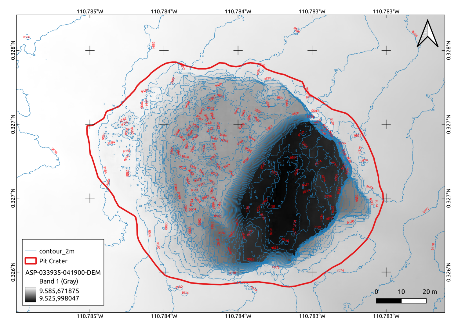
Figure 2. Map of the pit, showing the elevation in blue lines. The pit seems to have two main levels of collapse, an upper level with terraces on both sides, one less developed than the other, and the floor base level.
The area of the pit covers approximately 7978 m2, with a perimeter of 336 m. The edges of the enveloping hexagon have an average length of 56m. The bottom of the pit is at approx. 9525 m, while the rim has an average elevation of 9583 m, giving a height of ca. 60m. Analysis of the DEM shows two levels of collapse.The volume computation is underestimated due to the uncertainity of the left terrace. This terrace may be the results of the interpolation performed by the ASP algorithms due to the presence of hard shadows in the stereo pair. Considering that this left terrace cover almost half of the pit, we may infer that the estimated volume may be approximately double the measured volume. Further analysis, including shapes-from-shadows, may improve this result.
|
Parameter |
Value |
|
Volume |
~ 303.724 m3 measured, ~ 600 m3 estimated.
|
|
Area |
7978 m2 |
|
Perimeter |
336 m |
|
Average side length |
~ 56 m |
|
Average Max Elevation (RIM) |
~ 9583 m |
|
Min Elevation (bottom) |
~ 9525 m |
|
Maximum Depth |
~ 60 m |
|
Semi-Major axis |
~ 60 |
|
Semi-Minor axis |
~ 90 |
Table 1. Summary of the parameters of the Hexagonal Pit, retreived by analysing the high-resolution DEM.
As the last step, we imported the DEM as a terrain in Unreal Engine 5, to visualize it in simulated different light conditions, as shown in Figure 3.
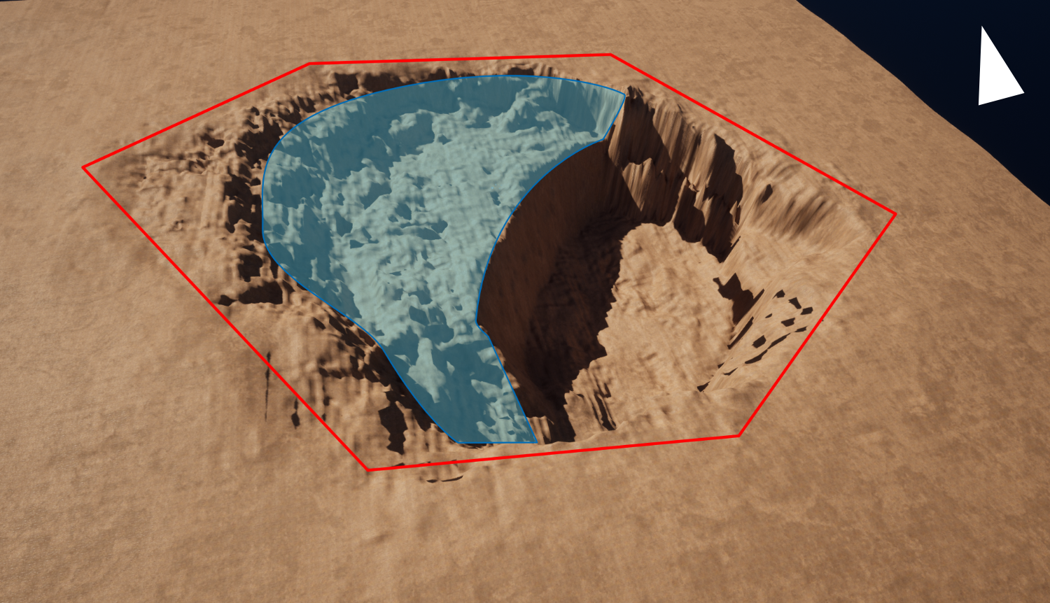
Figure 3. Pit DEM imported into Unreal Engine 5. The virtual sides of the hexagon are shown in red, while in cyan is highlighted the shadowed area in the stereo pair.
Conclusion:
The pit presented in this work has some unusual characteristics, its uncommon hexagonal shape, and the absence of connected secondary erosional mechanisms such as impact craters and pits could indicate the presence of structural elements that guided the rupture of the surface.
Funding:
This study is within the Europlanet 2024 RI, and it has received funding from the European Union’s Horizon 2020 research and innovation programme under grant agreement No. 871149.
References:
[1] D. Wyrick, D. A. Ferrill, A. P. Morris, S. L. Colton, and D. W. Sims, ‘Distribution, morphology, and origins of Martian pit crater chains’, J. Geophys. Res. Planets, vol. 109, no. E6, 2004, doi: 10.1029/2004JE002240.
[2] F. Sauro, R. Pozzobon, M. Massironi, P. D. Berardinis, T. Santagata, and J. D. Waele, ‘Lava tubes on Earth, Moon and Mars: A review on their size and morphology revealed by comparative planetology’, Earth-Sci. Rev., vol. 209, p. 103288, 2020, doi: https://doi.org/10.1016/j.earscirev.2020.103288.
[3] G. E. Cushing, ‘Mars Global Cave Candidate Catalog (MGC3)[abstract 3708]’, 2017.
[4] I. S. Hong, Y. Yi, J. Yu, and J. Haruyama, ‘3D modeling of lacus mortis pit crater with presumed interior tube structure’, J. Astron. Space Sci., vol. 32, no. 2, pp. 113–120, 2015, doi: 10.5140/JASS.2015.32.2.113.
[5] A. S. McEwen et al., ‘Mars Reconnaissance Orbiter’s High Resolution Imaging Science Experiment (HiRISE)’, J. Geophys. Res., vol. 112, no. E5, p. E05S02, May 2007, doi: 10.1029/2005JE002605.
[6] PDS Geosciences Nodes, ‘Orbital Data Explorer - Mars Holdings’. 2021. Accessed: Nov. 10, 2020. [Online]. Available: https://ode.rsl.wustl.edu/odeholdings/Mars_holdings.html
[7] G. Nodjoumi, C. Brandt, and A. P. Rossi, ‘Open-source planetary data processing environments based on jupyterhub and docker containers.’, p. 2, 2022.
[8] J. Laura et al., Integrated Software for Imagers and Spectrometers. Zenodo, 2021. doi: 10.5281/zenodo.5347823.
[9] R. Beyer, O. Alexandrov, and S. McMichael, NeoGeographyToolkit/StereoPipeline: NASA Ames Stereo Pipeline 2.6.1. Zenodo, 2018. doi: 10.5281/zenodo.1345235.
How to cite: Nodjoumi, G., Pozzobon, R., Sauro, F., and Rossi, A. P.: Morphometry of an hexagonal pit crater in Pavonis Mons, Mars, Europlanet Science Congress 2022, Granada, Spain, 18–23 Sep 2022, EPSC2022-1128, https://doi.org/10.5194/epsc2022-1128, 2022.