Atmospheric Dust monitoring derived from Orbital Near-Infrared Imaging Spectroscopy and Implications for RSL Formation
- Institut d'Astrophysique Spatiale, Université Paris-Saclay, CNRS, France (yann.leseigneur@ias.u-psud.fr)
Introduction: Dust is a high albedo material, which is omnipresent on Mars: both on the surface and suspended in the atmosphere. These micrometer-sized particles modify heat balance while being highly mobile: it is a major contributor to current Martian atmosphere and surface dynamic. Information on dust spatial and time distribution was already provided from numerous orbital and surface studies (e.g., [1,2,3]). However, some characteristics of the dust cycle remain uncertain, which is notably related to the large range of spatial scales of the dust movements: from Recurring Slope Lineae (RSL) to global dust storms, and with important interannual variability ([4,5]). Further global monitoring of dust movements with high spatial sampling and over several years may help improving our Martian dust knowledge. Here we present a new method used to derived near-infrared atmospheric dust optical depth using OMEGA observations acquired between 2004 and 2010.
Data and method: We use the near-infrared (NIR) imaging spectrometer OMEGA [6] onboard Mars Express, which acquired about 8300 observations of the Martian surface over that time range, with a spatial sampling typically close to 1 km.
Firstly, we quantify the prominent 2 µm atmospheric CO2 absorption band which is sensitive to airborne dust that reduces the atmospheric optical paths of the photons. We have developed a model to predict the CO2 optical depth under clear atmosphere conditions (notably depends on solar incidence angle, albedo and pressure). This allows to compare observed CO2 optical depth to these predictions and to derive the difference "ΔτCO2" (more details in [7]).
Then, we transform this ΔτCO2 into dust optical depth by a calibration with the visible (VIS) dust optical depth (from 880 nm images) measured by the Mars Exploration Rovers (MER) [2]. Concomitant MER/OMEGA observations are used to characterize the relation between ΔτCO2 and the ground optical depth (notably depends on incidence angle and albedo). Then, we extrapolated this relation to the whole OMEGA dataset to compute a VIS-NIR dust optical depth "τdust".
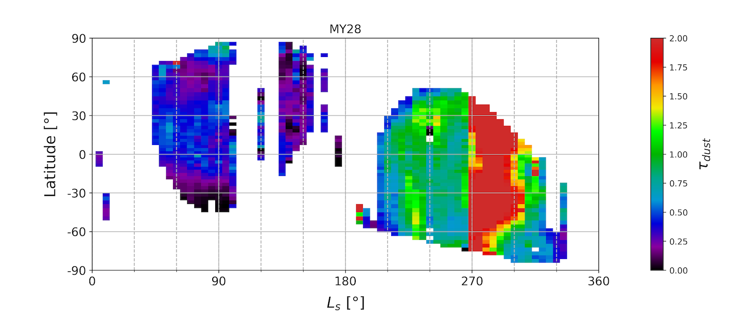
Results and discussion: We produce latitude/solar longitude diagrams, such as in Figure 1 for the Martian year 28. We observed well-known dust cycle characteristics: low dust optical depth values (<0.5) in the "clear atmosphere period" (solar longitude Ls=0-180°) and medium to high values (>1) during the dusty season (Ls>180°) such as the 2007 global dust storm during Ls=260-310°. We also observed medium-high values at northern and southern latitudes during Ls=220-250° that can correspond to dust storms identified in Hellas and Chryse [8]. Other main investigations were made with thermal-infrared (TIR) data [3,9]. We can notice an overall good agreement between our VIS-NIR study and TIR studies. But there are still differences that we studied by computing the dust optical depth ratio between our VIS-NIR values derived at 2 µm (and converted to 880 nm using MER) and the thermal ones at 9 µm. This ratio distribution reaches a maximum at 2.4, which is in agreement with the value (2.6) considered in [3] and also with the values found locally with MER [2]. This distribution is very large: 2.0 equivalent standard deviation, which may be related to the mean dust particle size variations according to [2] and to potential observational biases of each method (e.g., uncertainties in the vertical distribution of dust).

Figure 1: VIS-NIR dust optical depth (derived from the OMEGA dataset: see text for details) as a function of solar longitude (Ls) and latitude for Martian year 28.
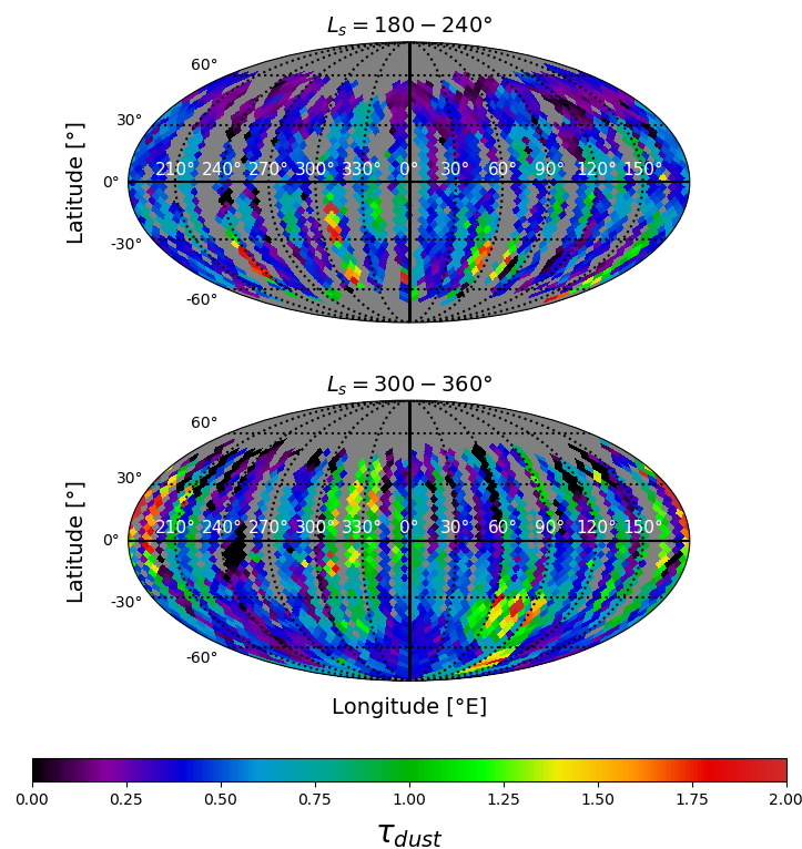
We also produce global seasonal maps of dust optical depth with a spatial coverage typically greater than 50% for most 60° wide intervals in solar longitude. We provide two seasonal maps of Martian year 29 in Figure 2 (Ls=180-240° and 300-360°). Firstly, we can notice some localized high values, such as in 355°E and 55°S on the Ls=180-240° map, that can be associated to a dust storm. Some main dust storm travel routes [8,10] can be identified, such as the Acidalia-Chryse route which is associated to medium-high dust optical depth values in these two maps. Activity is also observed at RSL sites in this area during both periods [11] represented in Figure 2: rapid disappearance events over Ls=180-240° suggesting dust deposition/horizontal dust transport [12], and RSL formation/lengthening over Ls=300-360° which suggest dust removal. This indicates that local surface movements may be related to large-scale atmospheric dust movements occurring at RSL location.

Figure 2: Two seasonal atmospheric VIS-NIR dust optical depth maps of Mars during Martian year 29. Top: Ls=180-240°; bottom: Ls=300-360°.
Conclusion: We have developed a new method to derived a VIS-NIR dust optical depth using near-infrared data (OMEGA). The method relies on CO2 absorption band at 2 µm and on a calibration procedure that we implemented, based on MER “ground truth” measurements. We constructed latitude/solar longitude diagrams (Figure 1) and global seasonal maps (Figure 2). Overall, our results are in a good agreement with previous thermal-infrared studies, but with some differences noticed by a particular distribution of the dust optical depth ratio between VIS-NIR and thermal-infrared, with a maximum occurrence value of 2.4. Then, preliminary results indicate that large scale atmospheric dust events may be related to local RSL activity occurring in the Chryse-Acidalia area. We will present further comparisons between atmospheric dust and RSL activities at the conference.
Acknowledgments: The OMEGA/MEx data are freely available on the ESA PSA at https://archives.esac.esa.int/psa/#!Table%20View/OMEGA=instrument.
References: [1] Smith M. D. (2004) Icarus, 167, 148-165. [2] Lemmon M. T. et al. (2015) Icarus, 251, 96-111. [3] Montabone L. et al. (2015) Icarus, 251, 65-95. [4] Szwast M. A. et al. (2006) JGR, 111, E11008. [5] Vincendon M. et al. (2019) Icarus, 325, 115-127. [6] Bibring J-P. et al. (2004) ESA Publication Division, 1240, 37-49. [7] Leseigneur Y. et al. (2021), 52nd LPSC, LPI contribution No. 2548, id. 1741. [8] Wang H. et al. (2015) Icarus, 251, 112-127. [9] Smith M. D. (2004) Icarus, 167, 148-165. [10] Battalio M. (2021) Icarus, 354, 114059. [11] Stillman D. E. et al. (2016) Icarus, 265, 125-138. [12] Vincendon M. et al. (2019) Icarus, 325, 115-127.
How to cite: Leseigneur, Y. and Vincendon, M.: Atmospheric Dust monitoring derived from Orbital Near-Infrared Imaging Spectroscopy and Implications for RSL Formation, Europlanet Science Congress 2022, Granada, Spain, 18–23 Sep 2022, EPSC2022-1145, https://doi.org/10.5194/epsc2022-1145, 2022.

