
MarsSI: Martian surface data processing service

- CNRS/Université de Lyon, Observatoire de Lyon, Villeurbanne, France (matthieu.volat@univ-lyon1.fr)
MarsSI (“Mars Système d’Information”, french for Mars Information System) is a platform and service to explore, process and retrieve data from orbiters. https://marssi.univ-lyon1.fr/MarsSI. This poster aim to help user to understand and use this service.
Introduction
Geological investigations of planetary surfaces require the combination of orbital datasets. Missions being often multiple-instruments platforms from multiple space agencies, the quantity of data available increased quickly. MarsSI is a platform designed to explore, process and retrieve Mars orbital data. It was certified in 2017 as french national Research Infrastructure by the Centre National de la Recherche Scientifique (CNRS) as part of the Planetary Surface Portal (PSUP, <https://psup.cnrs.fr/>).
As of 2021, it indexes the optical (visible, multi and hyper-spectral) data from the recent orbiter missions, and allow to request the creation of Digital Elevation Models on demand. The focus, as highlighted by figure 1 is to allow the user to browse and request ”ready-to-use” products in regards of calibration, refinements and georeferencing. The user will be able to visualize and interpret the data in GIS or remote sensing software.
MarsSI
MarsSI aim to provide both a way to explore and use data from space agencies archives, such as the Planetary Data System (PDS), but also run data processing pipelines to make this data ready for analysis and as a shared, collaborative, repository. This allows a scientific user to more easily access data from their raw level and proceed to surface investigations and interpretation.
Explore datasets
MarsSI access is done through a web application. This interface, completely updated in 2021, provide a map where product footprints can be visualized over various backgrounds (MOLA, Themis, CTX) to put data in context. Instruments, and if needed, their acquisition modes, are available as layers to display.
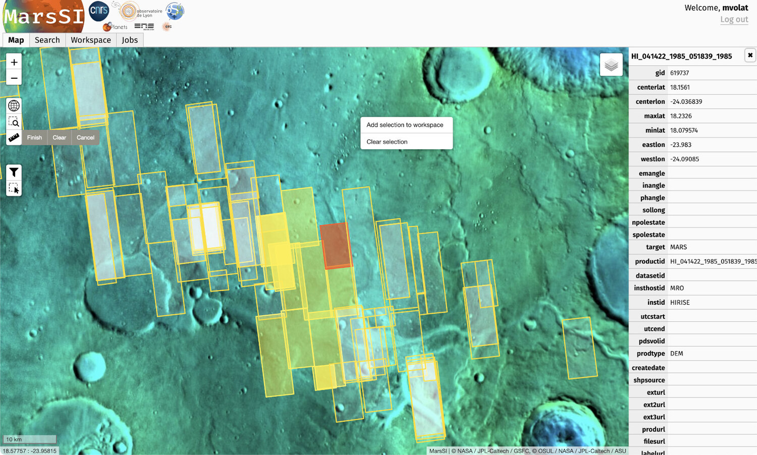
In this part of the interface, the user will be able to select products of interest and add them to a workspace summarizing the data he need to use.
Until now, MarsSI has focused on the most recent missions (ODY, MEX, MRO) optical datasets (visible, NIR, hyperspectral) and derived products.
Pipelines
Pipelines execution is done on demand, and requested from the workspace pane of the interface. Each type of product (based on instrument) has a specific pipeline defined. The pipelines are designed to be fully automated, run on MarsSI's computing cluster, and to not require any user input. This is done partially to ease the usage of the service, to avoid managing and storing multiple versions with slight differences that would make references to products more complex.
Basic pipelines operate to bring products to calibration and map projection (and georeferencing) steps. Those pipelines are usually based on ISIS (https://isis.astrogeology.usgs.gov/) for visible spectrum images.
More advanced pipelines allows to calibrate and create spectral parameter maps from CRISM hyperspectral cubes using the CRISM Analysis Toolkit (CAT, https://pds-geosciences.wustl.edu/missions/mro/crism.htm), and another to create stereophotogrammetry-derived DEMs from the CTX and HiRISE datasets (in complement of the pre-processed DEM datasets available) based on Ames StereoPipeline (https://ti.arc.nasa.gov/tech/asr/groups/intelligent-robotics/ngt/stereo/). One notable feature is that the DEM datasets are computed from the optical imagery datasets, showing all the stereo pairs deemed feasibles (based on overlap calculation and having a difference of incidence angle of at least 10°).
Documentation
MarsSI is documented through a wiki that provide information on both the platform usage and the products.
Conclusion
MarsSI (https://marssi.univ-lyon1.fr) aims to offer a way to the scientific communities to easily explore and perform the necessary processing steps for the data needed in their projects. MarsSI itself has seen superficial and architectural changes since it was recognized as part of a french national service, and aim to extend its datasets range in the future. Use of the service require registration that is free for a non-commercial usage.
Ackowledgements
MarsSI is a national Research Infrastructure, recognised as such by the French Ministry of Higher Education and Research. It was supported by the Programme National de Planétologie (PNP) of CNRS/INSU, co-funded by CNES. It was initialy supported by the European Research Council under the European Union’s Seventh Framework Program (FP7/2007-2013)/ERC Grant agreement No.280168.
How to cite: Volat, M. and Quantin-Nataf, C.: MarsSI: Martian surface data processing service, Europlanet Science Congress 2022, Granada, Spain, 18–23 Sep 2022, EPSC2022-213, https://doi.org/10.5194/epsc2022-213, 2022.