
The Chronology between the Development of the Tharsis Rise and Martian Valley Networks – A Discordance Analysis Perspective.

- European Space Agency, Noordwijk, Netherlands (rickbir.bahia@esa.int)
Introduction: Martian valley networks are evidence of surface run-off and past water cycles on ancient Mars [e.g. 1–3]. It is generally agreed that most Martian valley networks formed as a result of precipitation-fed fluvial [4, 5] in Late Noachian to Early Hesperian (~ 3.7 Ga) [e.g., 3], indicating this was the period of peak fluvial activity [e.g., 4].
The chronology between the development of Martian valley networks and the establishment of the giant volcanic province, the Tharsis Rise, is still uncertain. To better understand this chronology, attention has been paid to the relationship between valley orientation and topographic slope direction [6; 7]. Hereon, this type of analysis is referred to as discordance analysis – defined as the difference between valley orientation and the surrounding topographic surface slope direction of steepest descent [8]. Generally, the orientation of precipitation-fed rivers, and the valleys they carve, are controlled by topographic slope direction. Phillips et al. [2001] concluded that the valley network orientations were controlled by Tharsis-induced slopes, implying that the valleys predominantly post-date it. In contrast, Bouley et al. [2016] found that the orientations of the valley networks are consistent with calculations of the equilibrium shape of Mars with Tharsis Rise removed, implying that they pre-date it. These studies use low-resolution maps and do not indicate the directional discrepancy of discordance. As discordance is likely to occur over short spatial scales [8; 9] and arise from a variety of factors [8; 10], detailed mapping of smaller valleys is necessary to reveal its origin.
Bahia et al., [2022] applied discordance analysis to a latitudinal strip between 20° E to 20° W (Fig. 1); this is too far from Tharsis and its associated areas of topographic modification (e.g., the antipodal high) [11] to provide information about conformity/discordance between valley networks and Tharsis induced topography (Fig. 1). If Martian valley networks predominantly incised before the formation of the Tharsis Rise the valley networks around areas of topographic change would display some level of discordance.
In this study, valleys are mapped in high-resolution around the Tharsis Rise and the antipodal high regions, to apply discordance analysis. Reviewing any potential discordance patterns that immerge, or lack thereof, may reveal insight into the chronology between the development of the Tharsis Rise and valley network incision.
Data and Methods: Valley are identified in ESA Mars Express Orbiter – High/Super Resolution Stereo Colour Imager (HRSC) images (~ 25 m per pixel) and manually mapped, in the areas of expected topographic uplift induced by the Tharsis Rise [11], using the polyline function within ArcGIS Pro, defined under analogous characteristics as those of previous studies [e.g., 3, 8].
Tharsis-induced uplift is predicted to have occurred mostly before the Mid-Hesperian [16], so valleys incising surfaces younger than this age are unlikely to have been directly affected. To determine the relative surface ages, the Tanaka et al. (2014) digital global map of Mars was used [17].
For the present-day topography, the Mars MGS MOLA DEM 463m (MOLA DEM) was used [12-14]. Conformity between valley orientation and topographic surface slope direction is scale-dependent [8; 9; 15], hence a range of DEMs (1 km, 10 km, and 50 km per pixel) were produced from the MOLA DEM.
To find areas of discordance the present-day topographic slope direction of steepest descent (θ) and valley orientations (Ψ) will be measured. The ArcMap Pro Spatial Analyst – Aspect tool, which calculates the azimuthal direction of steepest descent for each square-shaped pixel, will be used to convert the DEMs into maps of θ. Ψ will be calculated using the ArcMap Spatial Analyst - Linear Direction Mean function. θ and Ψ will be extracted every 463m and an average for each valley/tributary will be calculated. The difference between the average θ and Ψ will be calculated to give a D (discordance) value for each individual valley/tributary.
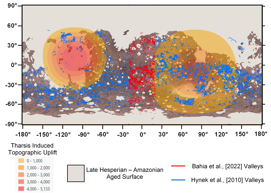
Fig. 1 Equirectangular projection of the Martian surface, showing the location of valleys mapped by Bahia et al., [2022] (red lines) using HRSC images (15 to 25 m per pixel) and Hynek et al., [2010] (blue lines) using THEMIS (Thermal Emission Imaging System) daytime and night-time IR (Infra-red) (100 m/pixel), MOC (Mars Orbital Camera) wide-angle (231 m/pixel), and MOLA (~500 m/pixel) topographic data. The grey areas are those assigned an age of Late Hesperian or younger [17]. The yellow to red shaded areas are those modeled to have experienced uplift as a result of the emplacement of the Tharsis Rise [11]. The base map is the Viking mosaic base map.
Initial Results: The cumulative area that is predicted to have experienced topographic uplift as a result of the emplacement of the Tharsis Rise [11] is around 64,770,287 km2; 36.5 % in the western hemisphere (Tharsis region) and 63.5 % in the eastern hemisphere (antipodal high). A lot of which is Late Hesperian to Amazonian in age (~ 40 %), particularly in the western hemisphere (Fig. 1), emphasizing the need to map the valleys of the antipodal high region.
At the point of abstract submission, 369 HRSC images have been mapped (~ 25,000,000 km2, ~ 40 % of the study area). In total, ~14,000 valleys have been mapped with a total valley length of ~160,000 km. On completion of this map, discordance analysis shall be performed and the discordance patterns assessed.
References: [1] Milton D. J. (1973) JGR, 78. [2] Carr M. H. (1995) JGR, 100. [3] Hynek B. M. et al. (2010) JGR, 115. [4] Kite, E. S. (2019) Space Sci Rev., 215:10. [5] Craddock R. A. and Howard A. D. (2002) JGR, 107. [6] Phillips et al., (2001) Science, 291. [7] Bouley et al., (2016) Nature, 531. [8] Bahia et al., (2022) Icarus, Accepted, 115041. [9] Black et al., (2017) Science, 356. [10] Bahia et al., (2021) LPSC 52, No. 2548. [11] Matsuyama and Manga (2010) JGR, 115. [12] Smith et al., (2001) JGR, 106. [13] Neumann et al., (2001) JGR, 106. [14] Lemoine et al., (2001) JGR, 106. [15] Lipps and Roberts (2020) Geophysical Research Letters, 48. [16] Bouley et al., (2018) EPSL, 488. [17] Tanaka et al. (2014), Planet. Space Sci., 95.
How to cite: Bahia, R.: The Chronology between the Development of the Tharsis Rise and Martian Valley Networks – A Discordance Analysis Perspective., Europlanet Science Congress 2022, Granada, Spain, 18–23 Sep 2022, EPSC2022-223, https://doi.org/10.5194/epsc2022-223, 2022.