
Martian Paleolake Outlet Canyons - Evidence for Controls on Valley Network Formation and a Waning Water Cycle
 1,
1,- 1European Space Agency, ESTEC, Noordwijk, Netherlands
- 2Leiden Observatory, Leiden University, Leiden, Netherlands
Introduction: Martian valley networks are evidence of ancient flowing water [1-3] during the Late Noachian to Early Hesperian period (3.7-3.5 Ga), likely as a result of precipitation-fed fluvial incision [4-5]. Mars is also home to paleolake outlet canyons, which formed as water accumulates within an impact crater's interior, forming a paleolake that eventually overflows, breaching the crater rim and causing flooding and incision of the outlet canyon over weeks to years [6-7]. The flow velocity is substantial enough to overcome topography. It has been hypothesized that valley networks that form after the outlet canyons may follow the troughs carved by them [6].
Valley formation rapidly decreased after the Early Hesperian (~ 3.7 Ga) indicating a waning water cycle. Evidence for the loss of water may be observed in valleys and paleolake outlet canyons. For example, Williams et al. (2001) [8] measured the width and depths of thousands of valleys, finding that some become narrower and shallower down their profiles, indicative of water loss down the valley.
In this study, we examine two paleolake outlet canyons with decreasing widths down-profile, which are adjacent to the Tharsis Rise, by applying paleohydraulic, morphometric, and morphological calculations. Examining these canyons will reveal information about their influence on adjacent valley networks. Additionally, the proximity of these canyons to faults associated with Tharsis deformation may reveal insight into the chronology between the formation of Tharsis and fluvial activity. Studies are currently divided on which formed first [9-12]. Furthermore, we aim to determine if valley systems display any evidence of water loss.
Data and Methods: Mapping was performed in QGIS, using MRO Context Camera (CTX) images (5 m/pixel) [18] and the Viking Digital Image Model (MDIM) [19] map (231 m/pixel) for the missing regions. Length, width, and slope (elevation taken from individual MOLA shots) values were extracted from the mapped valleys and outlet canyons. Discharge values were calculated down the paleolake outlet canyon's profile for both valleys and interior channels [13-14]. The MOLA Digital Elevation Model (DEM) (463 m/pixel) [20] was used to perform palaeohydraulic equations [15]. Hack's law (L = C*Ah; where, L is valley length, A is drainage area, and C and h are constants) was applied to valley networks running into the paleolake outlet canyon [15]. A h value between 0.5 and 0.6 is expected for precipitation-fed valley networks [15, 16]. In addition, we provide a valley depth cross-section down profile to probe if there is evidence of water loss.
Results: Our mapping revealed that these valley systems have experienced a diverse history of fluvial activity. The second valley system displays the remains of ancient hanging valleys (Figure 1) that are dissected by faults. The paleolake outlet canyon cuts through these faults. Finally, adjacent valley networks, one of which is at the source of a central channel within the outlet canyon, incise the valley walls of the paleolake outlet canyon. Knickpoints are observed within the elevation profile of one of the adjacent valley networks (Figure 2). From the discharge relationships for both valleys and interior channels, we have found a difference in discharge values on the order of magnitude ~103 m3/s.
Two of the adjacent valleys have a h value within the expected range for precipitation-fed networks, and the rest do not. Additionally, we observe disturbances in the valley's elevation profiles adjacent to the paleolake outlet canyon.
Although valley networks join the main outlet canyon, we measure no increase in width or depth after the introduction but measure a general decrease in width and depth (i.e., overall cross-sectional area) down the outlet canyon profile.
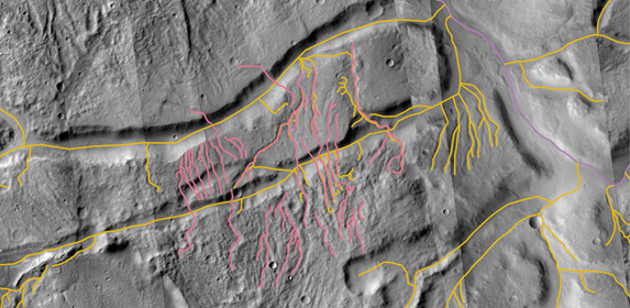
Figure 1. A section of the second valley system. Displayed are the hanging valleys (pink), remains of older valleys, and the faults (yellow) that are disrupted by the paleolake outlet canyon (purple) overlaid on CTX images.
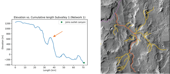
Figure 2. Left: Elevation profile of adjacent valley with a knickpoint (see orange arrow). Right: Associated valley (orange) with tributaries (yellow) connected to a paleolake outlet canyon (purple).
Discussion: These valley systems appear to have experienced the following chronology: (1) Ancient fluvial activity, resulting in remnant hanging valleys. (2) Tectonic activity, potentially associated with Tharsis, resulting in the production of faults that cross-cut the hanging valleys. (3) Paleolake outlet canyon incision, indicating substantial fluvial activity during this period. (4) Valley network formation, resulting in the incision of the walls of the outlet canyon. Knickpoints within these valleys [17], and the presence of channels possibly associated with these valleys within the outlet canyon, indicate that these valleys were potentially active after the paleolake outlet canyon ceased to be active. These channels, and the lack of conformity between the valleys and topographic adjacent to the outlet canyons, indicate that the valleys have followed the predefined trough formed by the canyons. These systems indicates that valley formation occurred before, potentially during, and after deformation associated with the formation of the Tharsis Rise.
The decrease in width, depth, and discharge of the paleolake outlet canyons down their profile indicates that there has been a loss of water. The cause of this water loss is currently unclear, however, it may aid in understanding the reduction of Mars’ water cycle.
References: [1] Masursky, H. (1973) JGR, 78(20). [2] Hynek, B et al., (2010) JGR: Planets, 115(E9). [3] Pieri, D. C. (1980) Science, 210(4472). [4] Jaumann, R. et al. (2005) Geophysical Research Letters, 32(16). [5] Carr, M. H., & Malin, M. C. (2000) Icarus, 146(2). [6] Goudge, T. A. et al., (2021) Nature, 597(7878). [7] Fassett, C. I., & Head III, J. W. (2008) Icarus, 198(1). [8] Williams, R. M., & Phillips, R. J. (2001) JGR: Planets, 106(E10). [9] Phillips, R. J. et al. (2001) Science, 291(5513). [10] Bouley, S. et al., (2016) Nature, 531(7594). [11] Black, B. et al., (2017) Science, 356(6339). [12] Bahia, R. S. et al., (2022) Icarus, 115041. [13] Irwin III, R. P. et al., (2005) JGR: Planets, 110(E12). [14] Gou, S. et al., (2019) Icarus, 328. [15] Hack, J. T. (1957) (Vol. 294). US Government Printing Office. [16] Bahia, R. S., et al., (2019) 50th LPSC, 1197. [17] Duran, S. et al., (2019) Scientific reports, 9(1). [18] Malin et al., (2007), JGR: Planets, 112. [19] http://astrogeology.usgs.gov/maps/mdim-2-1 [20] Smith, D. E. et al. (2001). JGR, 106(E10).
How to cite: Diamant, S., Bahia, R., Miguel, Y., and Sefton-Nash, E.: Martian Paleolake Outlet Canyons - Evidence for Controls on Valley Network Formation and a Waning Water Cycle, Europlanet Science Congress 2022, Granada, Spain, 18–23 Sep 2022, EPSC2022-268, https://doi.org/10.5194/epsc2022-268, 2022.