
 1,1,2
1,1,2- 1LPG Nantes Université, Univ Angers, Le Mans Université, CNRS, UMR 6112, F-44000 Nantes, France
- 2European Space Agency (ESA-SOC), Camino Bajo del Castillo, E- 28692 Villanueva de la Canada, Madrid, Spain
Abstract: The moon-coverage tool is a Python package currently used by ESA-SOC for the JUICE mission to plan and visualize Jupiter’s moons surface coverage. It supports instrument footprint projections and region of interest intersections.
Introduction: One of the key elements to assess the quality of an observation plan is to visualize its spatial coverage at different scales (global, regional and local). All the planetary missions, past, current and future use JPL/NAIF SPICE kernels to describe the position of the spacecraft and its orientation in space [1]. These files are usually produced by space agencies and require advanced users to interpret them to know when and how a given surface feature is visible on a planetary body.
A planning tool in Python: To simplify the identification of these opportunities, we developed the moon-coverage, a Python package built on top of spiceypy [2] that provides an object-oriented approach to perform spacecraft trajectory computations (Fig. 1), instrument field of view projections (Fig. 2) and region of interest intersections (Fig. 3). Originally developed for the ESA-JUICE mission, the tool can now handle any space mission (Europa-Clipper, BepiColombo, EnVision, Juno…).

Figure 1: JUICE temporal sequence of Europa flyby 7E1 (July 2nd 2032 with crema 5.0b23.1). The top panel represents the altitude of the spacecraft and the bottom the local incident angle. The orange color corresponds to the segment when the local incidence is lower than 90° (day side).
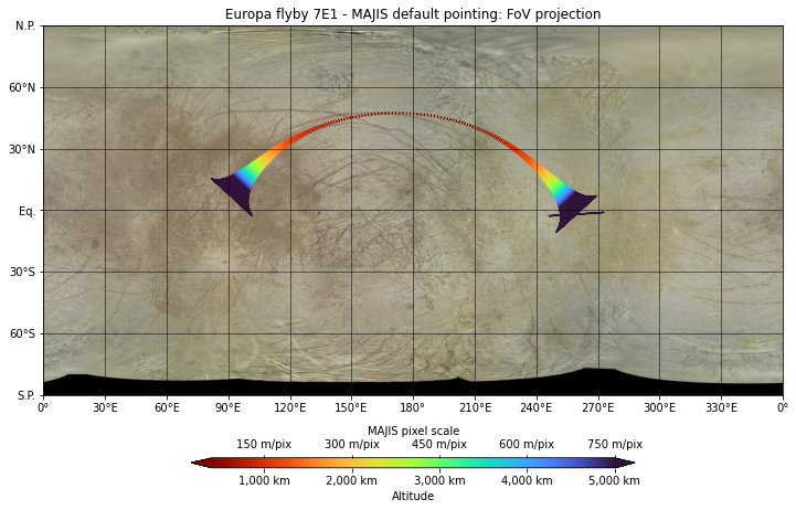
Figure 2: JUICE/MAJIS IR slit footprint during 7E1 flyby below 5,000 km. The trajectory is color-coded as a function of altitude and pixel scale.
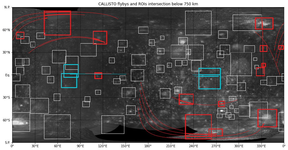
Figure 3: ESA/JUICE (red) and NASA/Europa Clipper (cyan) cumulative flybys over Callisto. The groundtrack below 750 km altitude are represented as solid lines. The large rectangles correspond to known regions of interest and are highlighted when the spacecraft groundtrack is intersecting them [3].
Resources: The source-code of the moon-coverage is publicly available on the JUICE Gitlab and distributed under open-source BSD license (https://moon-coverage.univ-nantes.fr). It is continuously tested on Python 3.8+ version and regularly deployed on PyPI. An extensive documentation is also available online with many examples than can be reproduced in Jupyter environments locally or ESA DataLabs.
Future developments: Currently the spacecraft/instrument pointing is based on the default camera kernels (ck). In a future release, we will allow the user to provide a Planning Timeline Request file (PTR) to perform custom adjustment of the attitude. We will also support planetary projections to display the result in polar/orthographic/sinusoidal views.
Acknowledgments: The moon-coverage is under active development at LPG (CNRS) and funded by ESA under 4000127262/19/ES/CM contract.
References: [1] Acton (1996) PSS, [2] Annex et al. (2020) JOSS, [3] Stephan et al. (2021) PSS
How to cite: Seignovert, B., Tobie, G., Vallat, C., Altobelli, N., and Belgacem, I.: The moon-coverage: a Python tool for mission and instrument planning, Europlanet Science Congress 2022, Granada, Spain, 18–23 Sep 2022, EPSC2022-341, https://doi.org/10.5194/epsc2022-341, 2022.