
 1,3,3,1,
- 1Institut de Recherche en Astrophysique et Planétologie, UMR 5277 CNRS, UPS, CNES, Toulouse Cédex 4, France (gwenael.caravaca@irap.omp.eu)
- 2LGL-TPE, Université de Lyon, Lyon, France
- 3Laboratoire de Planétologie et Géosciences, UMR CNRS 6112, Nantes Université, Nantes, France
- 4Department of Earth Sciences and Engineering, Imperial College London, London, UK,
- 5Purdue University, Lafayette, IN, USA
For more than a year now, the Perseverance rover of the Mars2020 mission has been exploring the Jezero crater in the northern hemisphere of Mars. This landing area was notably selected due to the presence of a large-scale fan-shaped sedimentary edifice in its western part at the mouth of Neretva Vallis (NV, Fig. 1a, e.g., [1]), that was interpreted to be a fossil deltaic system. Upon arrival in the crater in February 2021, remote observation from the ground were performed, allowing to answer this question with long-distance imaging using Mastcam-Z and SuperCam’s Remote Micro-Imager. Indeed, these observations allowed to identify with certainty structures characteristic of a Gilbert-type delta, confirming the fluvio-deltaic origin of this western fan [1].
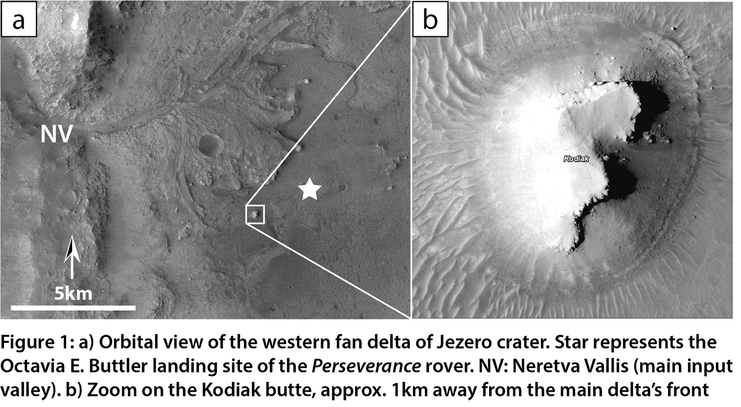
In this work, we focus on the Kodiak butte (Fig. 1b) situated ~1 km away from the current main delta front. This butte exhibits Gilbert-type structures of bottomsets, foresets and topsets characteristic of the deltaic suite, and as therefore been identified as being a remnant of a past distal extension of the western delta [1; 2]. This butte was imaged from the east during the earliest part of the mission (Fig. 2a), but we also took advantage of the “Rapid Traverse” route to the delta foot to gather images of its northern-facing side (Fig. 2b), giving us data to study the 3D geometry of the sedimentary rocks that make this butte. Here, we provide an overview of the facies and stacking pattern of the deltaic series observed at Kodiak.
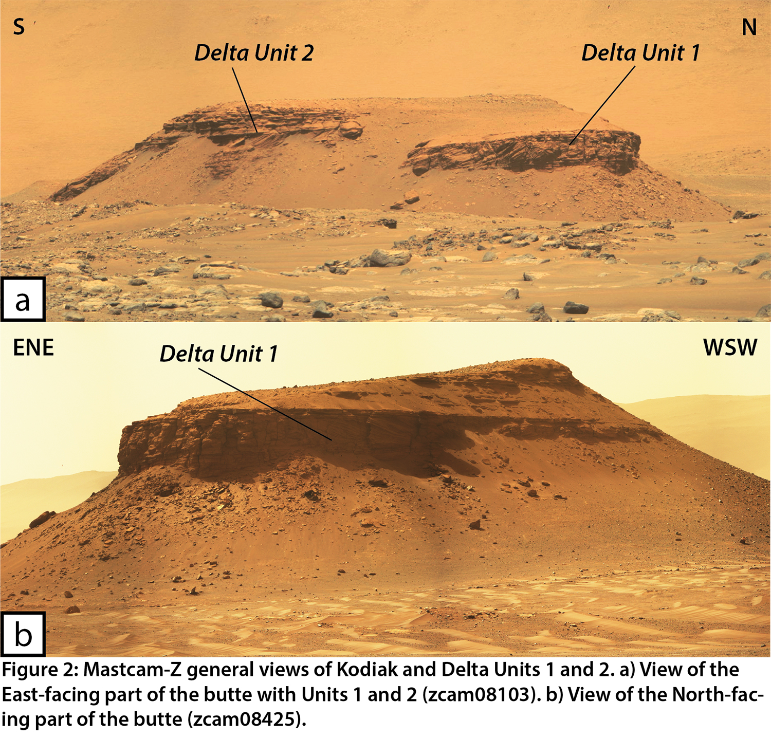
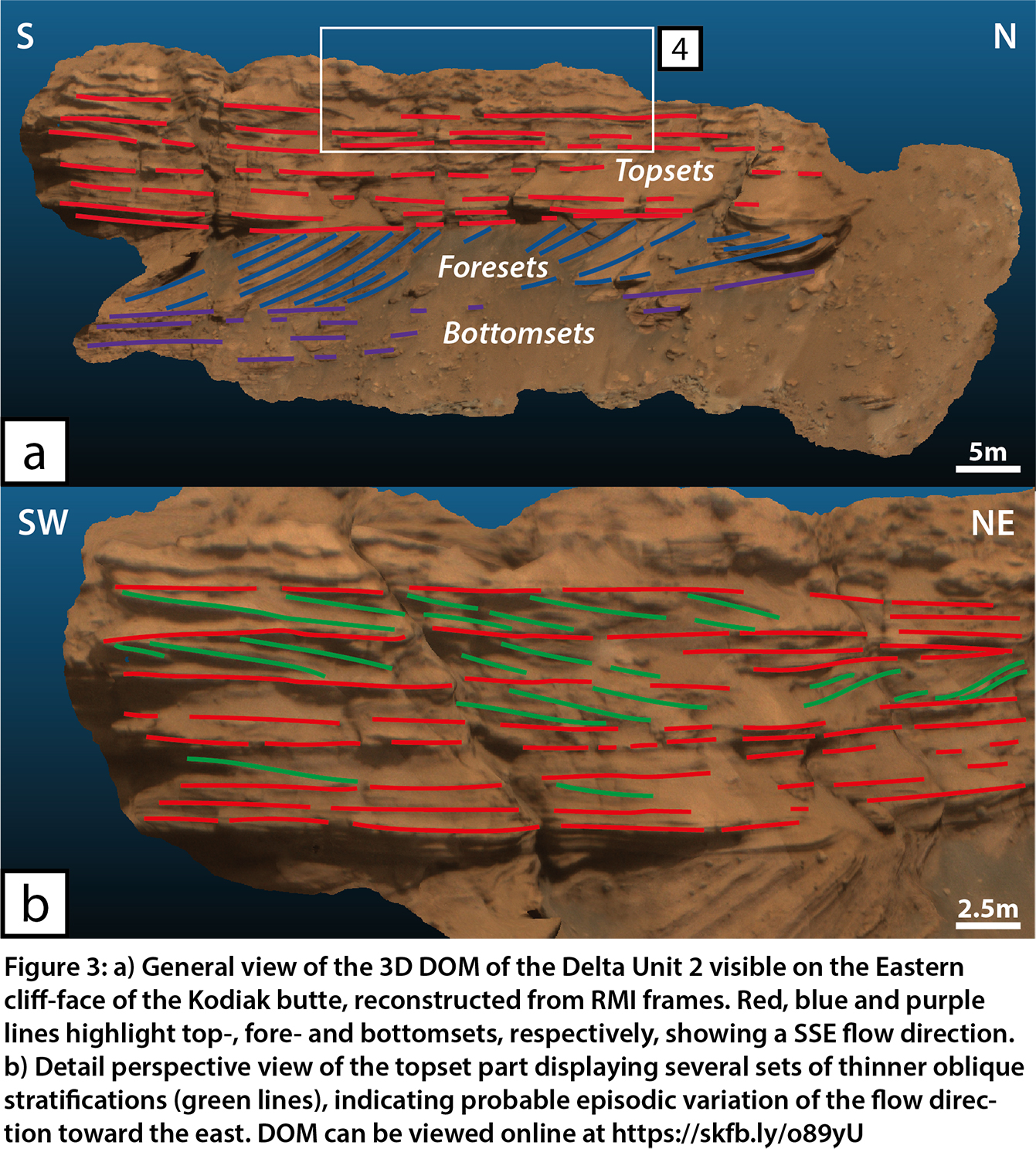
We use both 2D high-resolution image data acquired by Mastcam-Z and SuperCam’s RMI instruments, but also 3D Digital Outcrop Model (DOM) reconstructed from RMI remote observations (e.g., [2], visible online at: https://skfb.ly/o89yU). While both views help us in determining the stratigraphic architecture of the butte, the later being critical in assessing with more precision the sediment transport directions, and especially their temporal variations within distinct units [2]. That is, we are able to describe at least two main depositional episodes recorded at Kodiak, with Delta Units 1 and 2 (Fig. 2). Both units are characterized by a well-evidenced Gilbert-type succession of bottomsets, foresets and topsets, of a similar size and extension. The lower elevation and position further north of Delta Unit 1 (Fig. 2) indicates that it predates Delta Unit 2. An overall direction of transport toward the south-west is observed for this unit from the dip of foresets observed from both east and north faces.
Delta Unit 2 was observed in the first part of the mission, when the rover was positioned about 2 km away to the east, and was first characterized in [1]. High-resolution RMI images [3] allow us to characterize a sedimentary succession made of rocks whose texture ranges from coarse sandstones to (boulder) conglomerates, which is common for deltaic systems. A closer observation of the sedimentary architecture was possible using a 3D DOM made from RMI images [2] (Fig. 3). On this model, we were able to precisely delimits the different bottomsets, foresets and topsets (Fig. 3a), but also to provide measurements of the individual bed thicknesses within each interval with an average of 15 cm, 17 cm and 19 cm for bottomsets, foresets and topsets, respectively. After close observation, it appears that the topsets of Unit 2 also show that at least three sets of oblique stratifications do not follow the same transport direction than the other beds, evidencing a transport clearly toward the east (green lines in Fig. 3b). Also, individual beds exhibit a reduced thickness with an average of 13.5 cm per bed (Fig. 3b). While the overall unit 2 follows a usual stacking pattern for the deposition of a prograding delta, it appears that local and recurring variations in the energy and direction of transport occurs during the late-stages of the delta’s deposition, probably following onset of meandering beds or varying direction braided bars, an observation not dissimilar to the “curvilinear unit” observed on the main delta front at equivalent elevations [4].
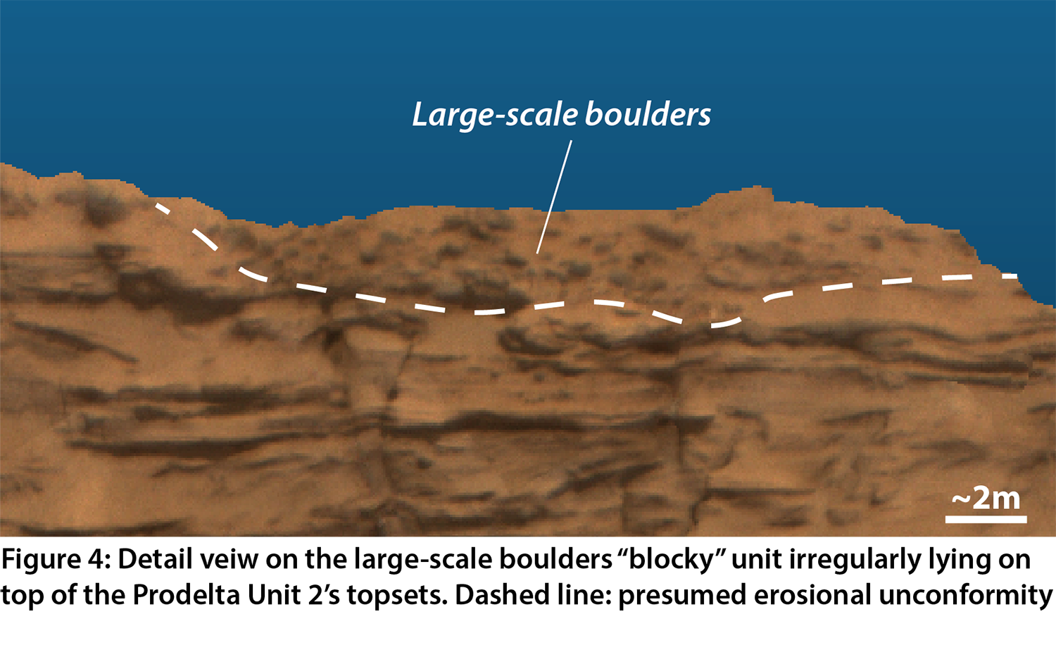
Finally, large-scale boulders are observed to irregularly and unconformably overlie both Delta Units 1 and 2 (Fig. 4) on top of the butte. These clasts have been measured on top of Unit 2 have an average long-axis size of ~52 cm, and range from 22 to 104 cm (Fig. 4). These poorly sorted and angular clasts are part of a clast-supported unit that seem to have deposited episodically a certain amount of time after the deposition of the main delta. This implies a strong decoupling between both settings, implying a complex history of the area, whose timely relations are yet to be ascertained.
While the exploration of the main delta of Jezero crater is just beginning, the characterization of the Kodiak butte, a remote distal remnant of the past deltaic fan, is already a “gold mine” of geologic information about the aqueous past of this area. The two different episodes in the delta’s history, represented by Delta Units 1 and 2, their inner variations, but also the presence of the later boulder conglomerate unit, are informing us about the late-stage evolution of the hydrological history of the Jezero crater. This is notably important since we are observing the foresets/topsets transition to occur at ~-2490 m in elevation, that is about 100 m lower than the modeled lake level from the craters’ outlet valley [1]. Following work to precisely characterize Delta Unit 1 and the (co-)relations to the main delta units [5, 6] will therefore be paramount in assessing the paleoenvironmental evolution of the basin, its fluvial activity, and its link to the regional to global climate of ancient Mars.
References: [1] Mangold et al., 2021, Science, 374, 6568. [2] Caravaca et al., 2022, LPSC, Abstract #1189. [3] Gasnault et al., 2021, LPSC¸ Abstract #2248. [4] Stack et al., 2020, Space Science Reviews, 216, 127. [5] Mangold et al., 2022, LPSC, Abstract #1814. [6] Gupta et al., 2022, LPSC, Abstract #2295.
How to cite: Caravaca, G., Dromart, G., Mangold, N., Gupta, S., Le Mouélic, S., Gasnault, O., Maurice, S., and Wiens, R. C.: Overview of the facies and stratigraphy of a distal Delta remnant at the Kodiak butte (Jezero crater, Mars), Europlanet Science Congress 2022, Granada, Spain, 18–23 Sep 2022, EPSC2022-345, https://doi.org/10.5194/epsc2022-345, 2022.