
Subsurface layer investigation of the glacial-like forms using SHARAD data
- 1Faculty of Geo-information Science and Earth Observation, University of Twente, The Netherlands (devanshi10kacholia@gmail.com)
- 2Faculty of Geo-information Science and Earth Observation, University of Twente, The Netherlands (w.h.bakker@utwente.nl)
- 3Faculty of Geo-information Science and Earth Observation, University of Twente, The Netherlands (h.aghababaei@utwente.nl)
INTRODUCTION
In recent years, the Martian world has drawn the attention of researchers all over the globe. Mars’ rich geological record and fascinating history led scientists and space organisations to be keen on studying the planet more closely. Several studies on Mars are primarily focused on determining the potential for life. (Nazari-Sharabian et al., 2020). The similarities between Mars and early Earth are a big part of why people want to study it. Little has changed on Mars since the Hesperian epoch, 2.9 billion years ago, due to the lack of plate tectonics (Victoria et al., 2018). As a result, unlike Earth, it is possible to look at Mars as a blank canvas due to no artificial structural advancements. The discovery of geological features that resemble small valleys and river plains (Rice et al., 2008) has only raised the possibilities of finding water on Mars in some form. Many dramatic events occurred on Mars' glacial past, leading to the construction of valleys, river plains, glacial landforms, and other features. We have recently learned a lot more about such features.
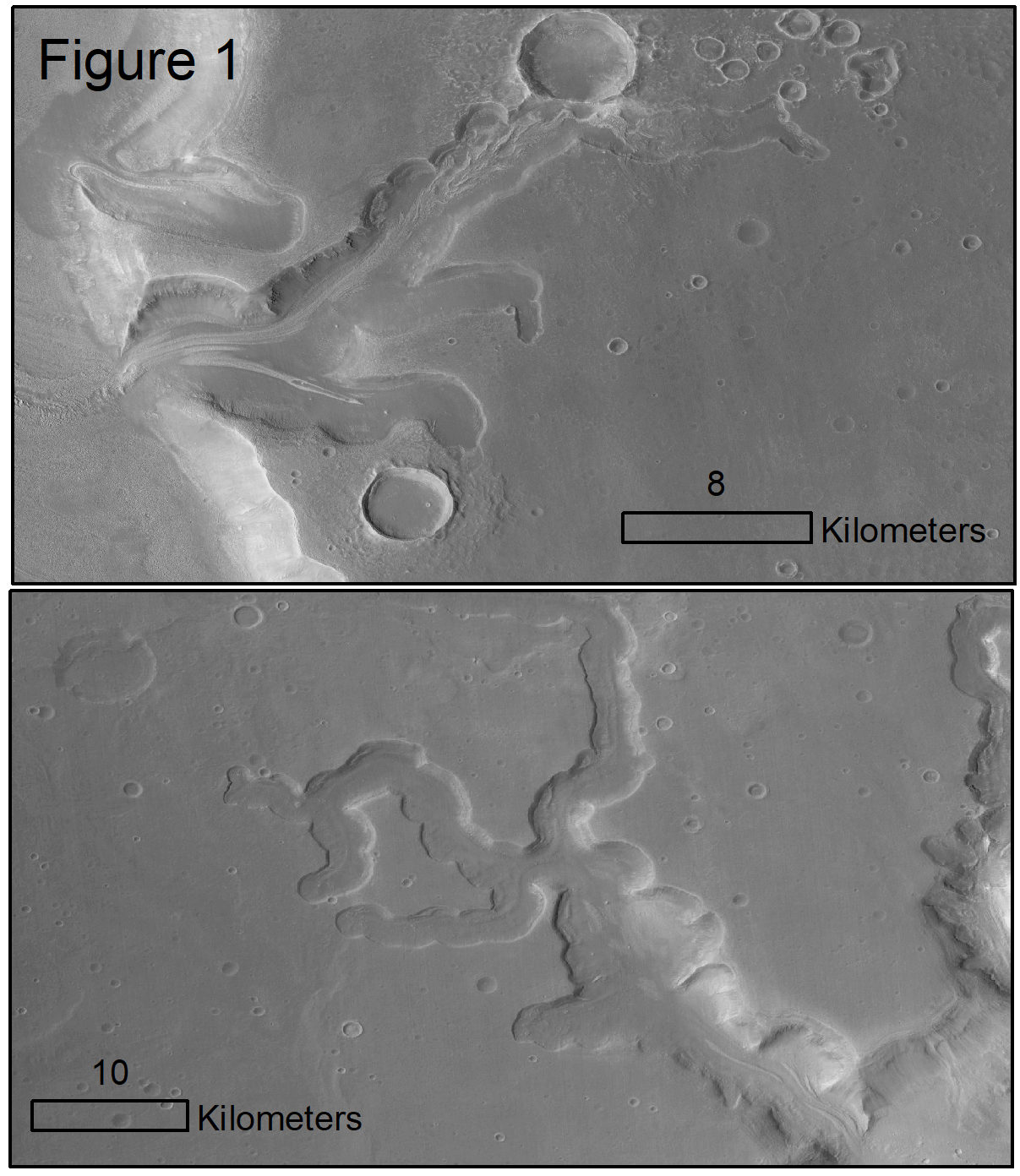
Mars’ extreme glacial history led to significant changes and the formation of interesting features such as glacial-like landforms on the planet. Changes in the orbital and rotational parameters have allowed ice from ice-rich polar regions to shift towards the equator (Mischna et al., 2003). This process is termed mid-latitude glaciation (Hepburn et al., 2020; Milliken et al., 2003). Furthermore, these formations have flow-like geomorphology as shown in figure 1, indicating the presence of ice underneath these landforms (Holt et al., 2008; Souness et al., 2012). Examining the depths of these GLFs may yield information on the events that have manifested in significant geographical and climatic changes.
1.1 Research Gaps and Objective
There are studies that focus on the GLFs and their formation over the years (Degenhardt and Giardino, 2003; Holt et al., 2008; Karlsson et al., 2015; Souness et al., 2012). Attempts to date these viscous flow features by studying their composition (Hepburn et al., 2020) have resulted in some progress in understanding Mars' glacial past through these landforms. However, there is still a lack of knowledge of the depths of the GLFs. The reasons for the absence or presence of any buried deposits beneath these landforms are largely uncertain. Although there have been papers targeting these landforms and layers underneath them, there is a requirement to evaluate their complete potential through the extension of radar datasets. Because the undersurface deposits on Mars are mostly dust and dirt (Dundas et al., 2018), detecting them with optical images is difficult. Therefore, this study attempts to examine the depths of glacier-like forms in the mid-latitudes of Mars using SHARAD radargrams.
1.2 Data
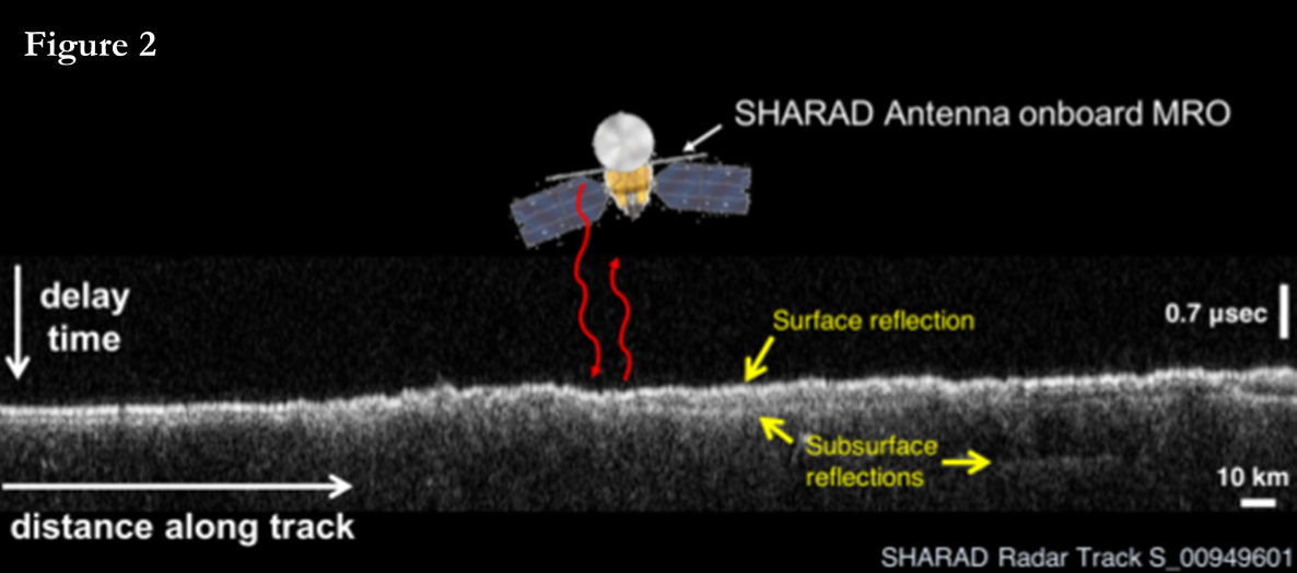
The Shallow Subsurface radar instrument on Nasa's Mars reconnaissance orbiter produces very long wavelength radar imagery and can be utilized to detect subsurface layers on Mars. Unlike Earth, ice on the mid-latitudes of Mars sublimates when on the surface and can be found underneath the surface (subsurface). Therefore, to confirm or reject the presence of subsurface deposits on Mars, SHARAD's pulses are used for better penetration of signals into the target landforms. SHARAD’s radar pulses can reach up to 1000-1500 m depth and operate between 15-25 MHz frequencies. The data obtained by the instrument are in the form of radargrams which can be used for geospatial analysis. As shown in figure 2, the radargrams represent power returned at several time delays (Y-axis) along the track of the distance traveled by spacecraft (X-axis) (Bramson and Petersen, 2020). There is an increase in the power (at the time delay) returned from the radar if contrast is realized in the material properties. A material's response can be expressed by dielectric constant or permittivity and is related to the material's refractive index.
1.3 Methodology
1.3.1 Target glacial-like forms
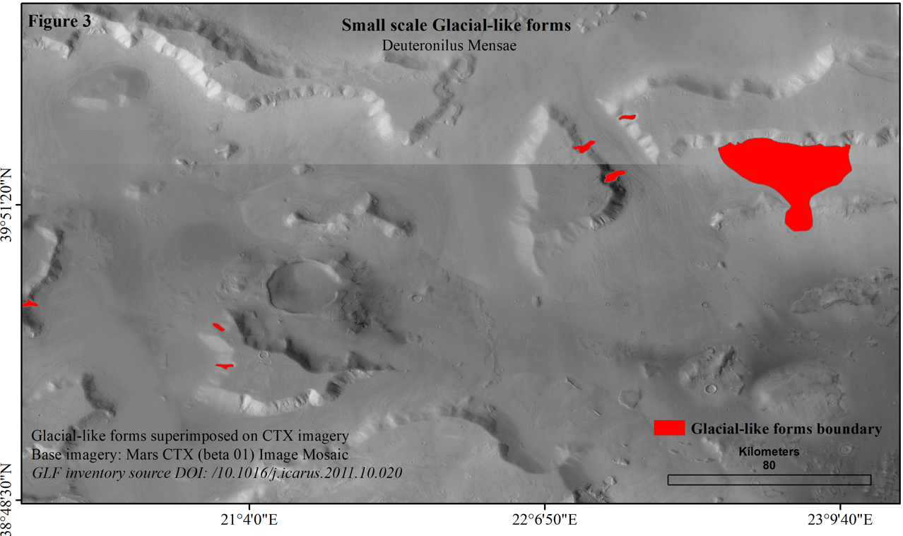
Most small-scale lobate debris aprons, i.e., features that stretch for less than 5 km, are present in the Northern Lowlands (Hepburn et al., 2020) as shown in figure 3. The selection of a few interesting GLFs is made based on the evidence of hydrous minerals in the area. In the study (Pan and Ehlmann, 2018), Deuteronilus Mensae is closely studied for phyllosilicates and hydrated silica using CRISM images. In this study, the target landforms are selected based on the locations of these hydrous minerals shown in Pan and Ehlmann’s research.
1.3.2 Processing Radargrams
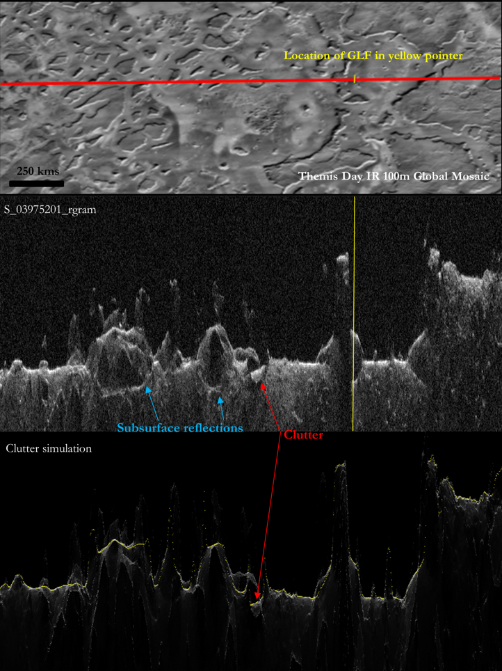
Off-nadir reflections: The performance of the radar sounder is determined by several factors, including surface and subsurface reflectance, receiver noise level, and topography. At longer delays, topographic features away from the nadir track will add undesired noise or "clutter" power (Seu et al., 2007). Therefore, topographical changes can induce different levels of clutter echoes. Bright reflections from off-nadir surface topography cause radar clutter, resulting in late returns that could be misinterpreted for subsurface returns (Bramson et al., 2015). Hence, we compare our radargrams to their respective clutter simulations produced using Mars Orbiter Laser Altimeter.
1.4 Results
In figure 4 original radargram covering a GLF rich in Fe/Mg phyllosilicates in the Deuteronilus Mensae region is shown along with the Themis mosaic indicating the cross-section profile of the radargram. The radargram is compared to a clutter simulation generated using the Colorado SHARAD Processing System. The subsurface reflections can be recognized with the use of clutter simulations. Specific subsurface interfaces are visible in the radargrams directly under the GLFs which are absent in the simulations. This indicates the presence of subsurface deposits under the phyllosilicate-rich GLF.
However, utilizing SHARAD radargrams to look under small-scaled GLFs has inherent difficulties, and due to resolution restrictions, it is difficult to look closely at the radargrams. Deuteronilus Mensae has a complex terrain; hence, in some instances, subsurface reflectors are very similar to the surface reflector caused due to the instrument’s sidelobes (Bramson et al., 2015). Therefore, the radargrams need to be very carefully compared with the simulations to grasp better what can be called a subsurface deposit under the target landforms.
How to cite: Kacholia, D., Bakker, W. H., and Aghababaei, H.: Subsurface layer investigation of the glacial-like forms using SHARAD data, Europlanet Science Congress 2022, Granada, Spain, 18–23 Sep 2022, EPSC2022-382, https://doi.org/10.5194/epsc2022-382, 2022.