
Modeling of fluvial episodic events at a channel in Nepenthes Mensae region of Mars
 1,2,1,3,
- 1Centro de Astrobiología (CSIC/INTA), Instituto Nacional de Técnica Aeroespacial. Ctra de Torrejón a Ajalvir, km 4 28850 Torrejón de Ardoz, Madrid. Spain
- 2Unidad de Geología, Universidad de Alcalá. Alcalá de Henares, Madrid. Spain
- 3Departamento de Ingeniería Térmica y Fluidos, Universidad Carlos III. Madrid. Spain
- 4Facultad de Ciencias Geológicas, Universidad Complutense de Madrid. Madrid. Spain
1.Introduction
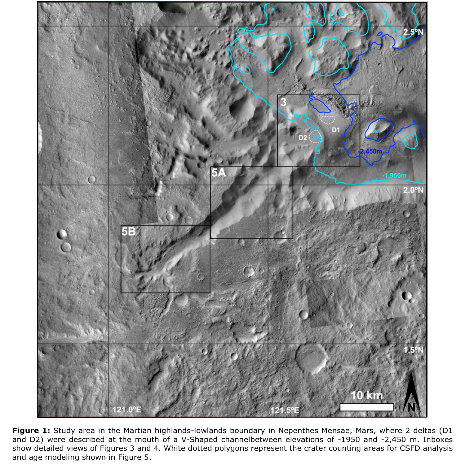
A straight V-shaped channel with two overlapped fan-shaped deposits at the mouth, close to a possible fissure volcano (121.43°N,2.16°E) in Nepenthes Mensae region of Mars (Fig.1) has previously attracted our attention [1]. The MOC-NA and the first HRSC images in the area allowed us to propose a hydrological evolution for the area, including water level variations over time [2]. Now, we revisited the site with higher resolution images and topography to model [3] the mechanisms that created the fan-shaped deposits with a recent methodology [4]. This will expand our understanding of the area's fluvial processes by adding to the debate over variations in water levels at long-standing water bodies. Here we present the preliminary geological observations that will constrain the forward topographic deconstruction and the numerical modeling.
2.Methodology
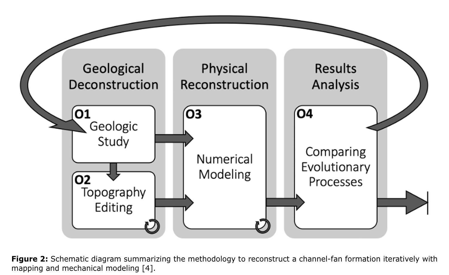
We plan to reconstruct the hydrogeological evolution of the area using a three-step iterative model (Fig.2,[4]). Starting with the geological study of the area (Fig.2,O1), we used a GIS (QGIS 3.16) with recent imagery (CTX,HiRISE) and topography (HRSC). We refined the previous geomorphological description of the features and dated the two hydrologic events through CSFD analysis using the CraterStats2 software [5]. After identifying topographical constraints for the modeling process [3] we performed a series of topographic deconstructions (Fig.2,O2) that would be the input for the numerical modeling (Fig.2,O3).
2.1.Geological Deconstruction
2.1.1.Geologic study
Two major fluvial phases were proposed at first based on the appearance of two overlapped deltas [2]. The first, resulting in the formation of an alluvial fan at the bottom (D1), could have formed in the absence of a standing water table; the second, a pristine Gilbert-type delta (D2), could have formed at roughly -1,990 to -1,950m elevation water table [2,6]. According to HRSC-derived topography, the base of D1 is at around -2,540m elevation (Fig.1), and Contact 1 of Oceanus Borealis is at about -2,499m elevation [7,8]. This could support the hypothesis that D1 originated as an alluvial fan near the water's edge.
Other deposits at the base of both deltas are visible on high-resolution images, which could result from prior fluvial processes (Fig.3). The images demonstrate the presence of other distal deposits between the two deltas (Fig.3), most likely due to the gradual rise of the water table, resulting in a reduction in the areal extension of the deposits while they increase in thickness. The presence of benches at elevations ranging from -1,400 to -2,400m [2,6] may indicate a progressive change in the water table level.

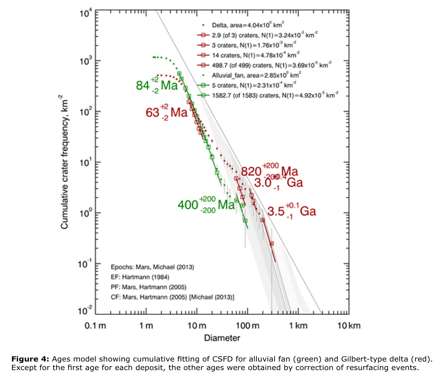
The CSFD analysis allowed both deltas to be dated (Fig.4). Due to resurfacing events, D1 does not reveal ages older than 400Ma (400 and 84Ma). Since ages of 3.5 and 3Ga have been fitted, D2 was produced in Hesperian. Other ages of 820 and 63Ma are produced by resurfacing processes. Although we found younger resurfacing ages, the age of creation of D2 fits with the age of other deltas in the vicinity [6]. Resurfacing activities and aeolian events are aided by channels slicing the top surface of D2 (Fig.3).
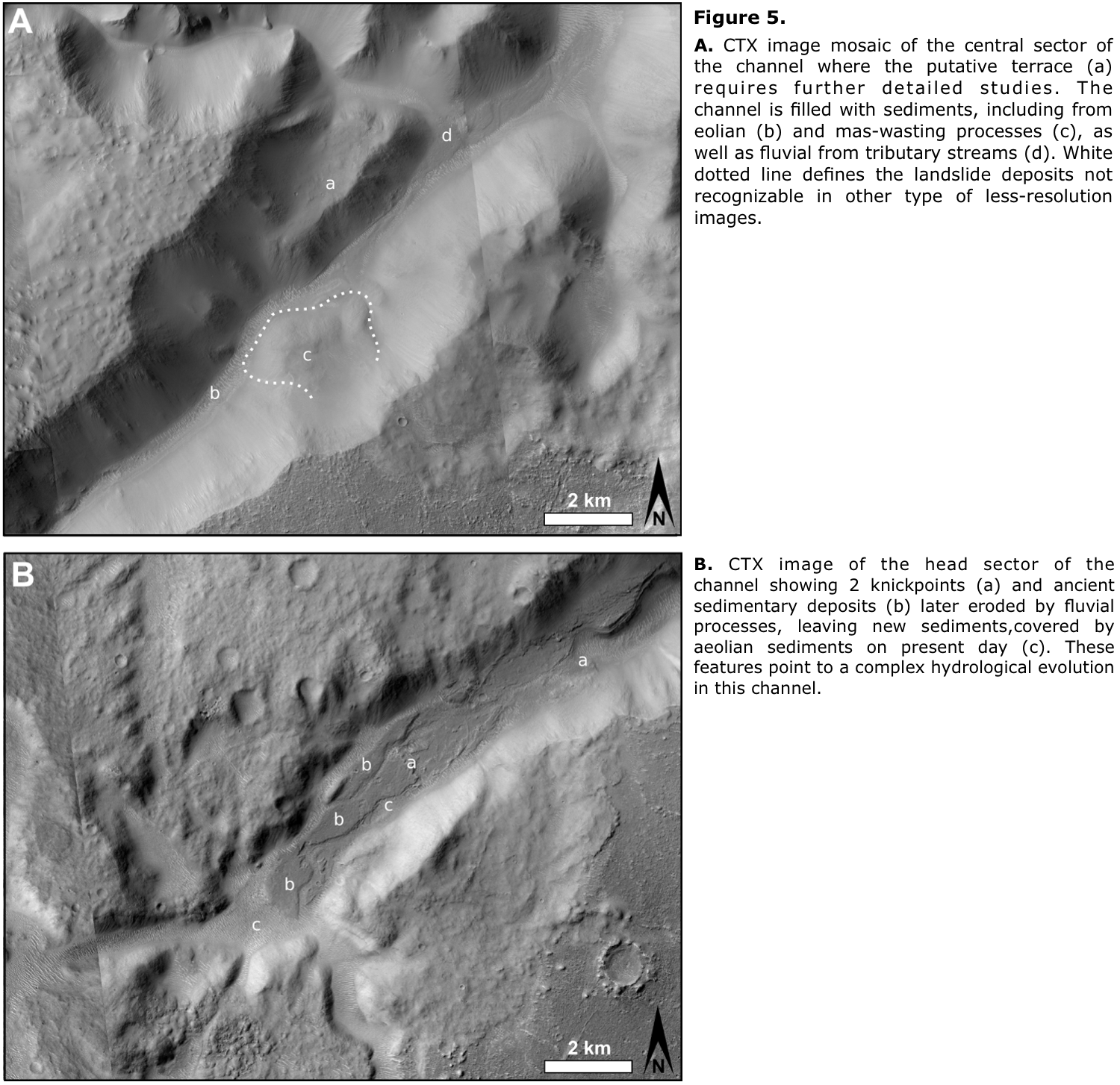
These sedimentary deposits were made possible by materials carried by a river flow after excavating a V-shaped valley, which is now filled with fluvial, aeolian, and sediments from mass-wasting processes, such as a rotational landslide (Fig.5A). A probable fluvial terrace was presented [2]; however, it could not be now validated using high-resolution images. Other features, such as two knickpoints, are now visible (Fig.5B), indicating (1) the presence of resistant material acting as local base levels or (2) the decline of water table levels at the channel mouth [9]. Also evident are sedimentary deposits at the top section of the channel, as well as along the degraded channels, such as those coming from the tributary, which gives a key to reconstructing the sequence of fluvial events in this system.
2.1.2.Topography editing
Having differentiated the phases for the formation of hydric geomorphologies, their characteristics, and the extent of other subsequent processes altering the relief, we modified the topography to emulate the one prior to the hydrological process, also determining the position and volume of the mobilized material. We tested the different working hypotheses with different deconstructions that will be iteratively refined.
2.2.Physical reconstruction: Numerical Modeling
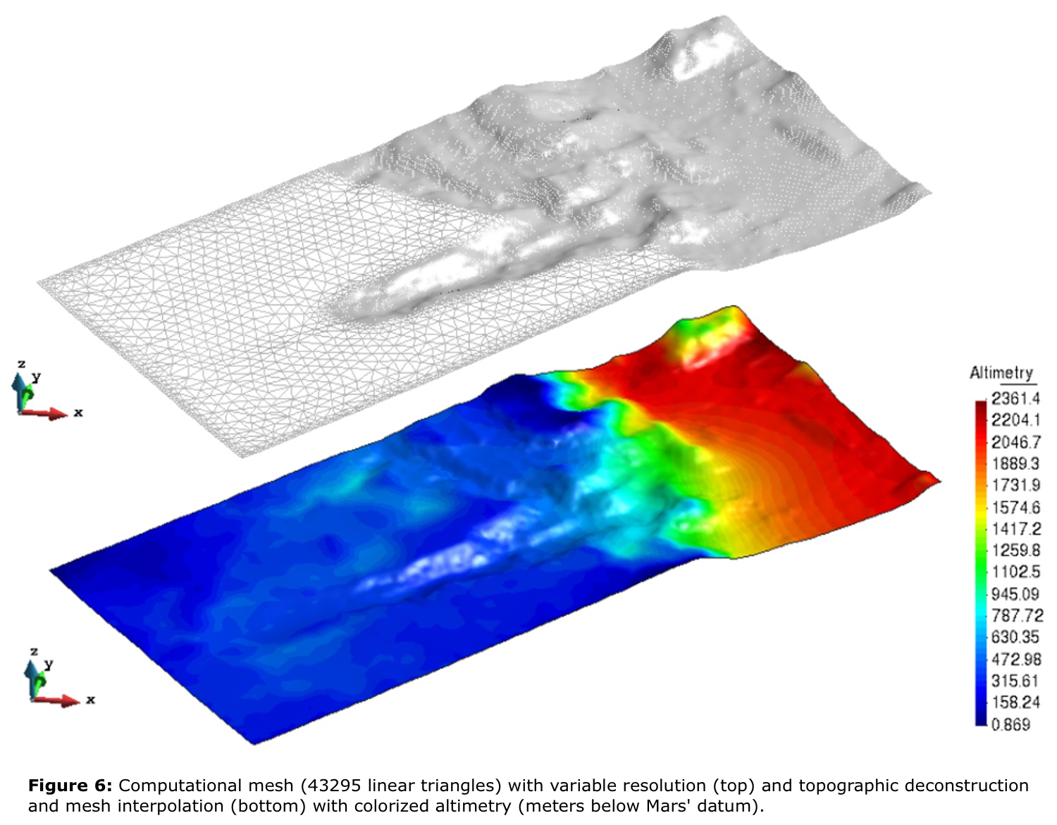
The initial conditions and topographies are extracted from the geological deconstruction, which must be interpolated in a computational mesh (Fig.6). Subsequently, a two-phase (i.e., soil and water) model based on the depth-integrated Navier-Stokes equations will be applied [10].
The simulations will provide the volume of mobilized material, type of material (including its water content), a final topography, and the duration time of the event to be studied [3].
2.3.Results Analysis
A comparison of the evolutionary processes by evaluating the differences found between the simulation results and the studied morphologies in terms of volumes of mobilized material, flow directions, final slopes, and shape will be accomplished. Based on the discrepancies obtained, it will be decided whether the iterative process must be finalized or a new deconstruction/reconstruction process must be started.
3.Expected results
This methodology will provide a better understanding of the hydrogeological processes that lead to the formation of the deltas in Nepenthes. Information about the water content, duration of the processes, and the existence (or not) of a layer of water in the lowlands will be obtained.
Besides, the proposed technique can be applied elsewhere on the surface of Mars, being possible to extend it to the study of other geological processes and even other planetary bodies. In this way, this study will help shed light on how and when the geological and environmental evolution of Mars has taken place.
Acknowledgements
The authors thank the AEI projects PID2019-107442RB-C32 and MDM-2017-0737.
References
[1]de Pablo and Pacifici, 2006. EPSC2006-A-00447. https://adsabs.harvard.edu/pdf/2006epsc.conf..447D
[2]de Pablo and Pacifici, 2008. Icarus, 196(2):667-671.https://10.1016/j.icarus.2008.04.005
[3]Herreros et al., 2021. EPSC2021-116.https://doi.org/10.5194/epsc2021-116.
[4]Molina et al., 2021. EPSC2021-129.https://doi.org/10.5194/epsc2021-129.
[5]Michael and Neukum, 2010.https://10.1016/j.epsl.2009.12.041.
[6]Arnay and Gutiérrez, 2020. Geomorphology, 359. 10719.https://doi.org/10.1016/j.geomorph.2020.107129.
[7]Clifford and Parker, 2001. Icarus 154, 40-79.https://doi:10.1006/icar.2001.6671.
[8]Di Achille and Hynek, 2010. Nature Geoscience 3, 459-463.https://doi.org/10.1038/ngeo891.
[9]Durán et al., 2019. Sci Rep 9, 15153.https://doi.org/10.1038/s41598-019-51574-2.
[10]Pastor et al., 2009. Engineering Geology, 109(1–2): 124-134. https://10.1144/1470-9236/04-038.
How to cite: Molina, A., de Pablo, M. Á., Herreros, I., Pertuz Domínguez, A., Roldán Caselles, G., and Martínez, A.: Modeling of fluvial episodic events at a channel in Nepenthes Mensae region of Mars, Europlanet Science Congress 2022, Granada, Spain, 18–23 Sep 2022, EPSC2022-413, https://doi.org/10.5194/epsc2022-413, 2022.