
Relationship between the density/type of thermal-contraction polygons and the geology of the substrate at the Martian mid-latitudes.
 1,
1,- 1Laboratoire de Planétologie et Géosciences, CNRS UMR 6112, Nantes Université/Université d'Angers/Le Mans Université, France
- 2Geography Department, Dawson College, Montreal, QC, Canada
- 3NASA Jet Propulsion Laboratory, 4800 Oak Grove Drive, Pasadena, CA
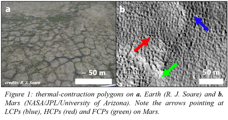
Introduction: On Earth, sharp drops in temperature can cause ground cemented by ice to contract, forming surficial cracks (Figure 1a) that can join to form polygonal patterns. These polygons show no elevation difference between their margins and centres, and are called here flat-centred polygons (FCPs). Water and/or sand [1, 2, 3] can infill the troughs and freeze, forming ice or sand wedges. These grow seasonally, uplifting polygon margins above the centres, forming low-centred polygons (LCPs). When wedges degrade, the elevation of the margins decreases below that of the centre, forming high-centred polygons (HCPs).
The martian mid-latitudes exhibit similar polygons (Figure 1b), currently thought to form by ground thermal-contraction [4]. Whereas debate ensues over the nature of trough infill, recent work provided evidence for ice wedges in Utopia Planitia [5] – with implications for liquid water stability and subsurface water ice availability.
Here we study variations in polygon distribution/morphology in relationship with different geological units in UP (Figure 2) and Arcadia Planitia (AP; Figure 3), where polygonised units have been reported [6]. Our study seeks to understand: 1. how the substrate nature favoured/inhibited the formation and/or preservation of ground ice, and 2. whether polygon characteristics (e.g. morphology, spatial density) can give insights into geological properties of their substrate.
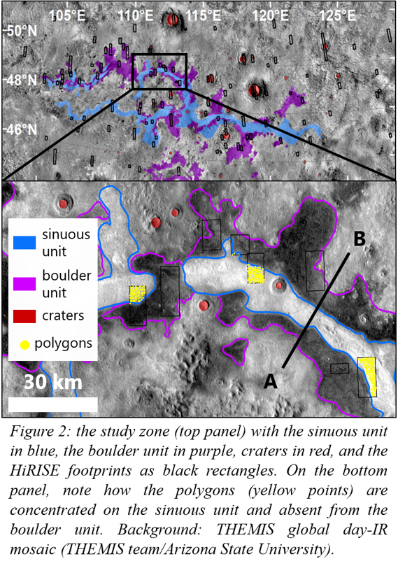
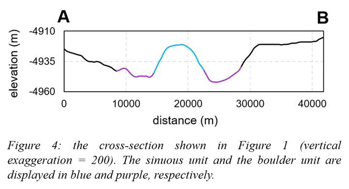
Methods: In UP (Figure 2a) we mapped polygons (5-25 m scale) on 104 images from the High-Resolution Imaging Experiment (HiRISE, 25-50 cm/pixel) – 55 from [5] and 49 new ones. We used a grid-based mapping approach [7]: we gridded images into 500x500 m squares, and in each square the presence of a given polygon type was noted when at least five specimens were present. We mapped the extent of three units: a sinuous unit, a boulder unit, and craters (Figure 2) with imagery from the Thermal Emission Imaging System (THEMIS), the Context Camera (CTX) and HiRISE. We also produced a topographic cross-section of contacts between the sinuous and the boulder units (Figure 2b) with data from the Mars Orbital Laser Altimeter (MOLA).
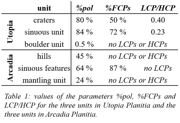
For each unit we calculated three parameters: 1. the percentage of polygonised squares (%pol), 2. the percentage of polygonised squares containing solely FCPs (%FCPs), and 3. the ratio number of squares containing LCPs / number of squares containing HCPs (LCP/HCP). We suggest that these parameters reflect properties of the substrate: 1. its cementation by ice, 2. its capacity to grow ice wedges (i.e. massive ground ice), and 3. its capacity to preserve ground ice.
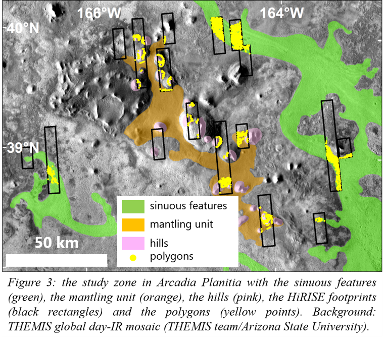
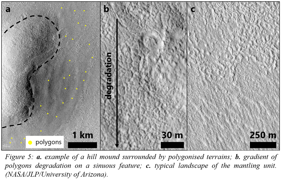
We used the same approach on 18 HiRISE images in AP, where we mapped the extent of three units based on [6]: hills, a mantling unit, and sinuous features.
Results: We display and compare results for each unit in Table 1. In UP, topography and cross-section data (Figures 2b & 4) show that the boulder unit is at a lower elevation than the sinuous unit and also the surrounding terrains. In AP, hills exhibit FCPs around their central mound (Figure 5a); sinuous features bear FCPs, HCPs and what we interpret as degraded HCPs (Figure 5b); and the mantling unit bears few polygons, but is mostly covered in extensive brain terrain and linear ridges [6] (Figure 5c).
Discussion:
Utopia Planitia: The material infilling craters is highly polygonised (high %pol), show evidence of past ice wedge formation (low %FCPs), and preserved more ice wedges (high LCP/HCP). Therefore, it should be porous and ice-rich [8, 9], suggesting sediment that underwent ice deposition events. This could have been enhanced by a cold-trap effect [5, 10].
The boulder unit exhibits boulders, fractured rocks and nearly no polygons - suggesting a massive material hindering ground ice emplacement and thus ground cracking. The sinuous unit is higher in elevation and highly polygonised (high %pol), showing evidence of ice wedge activity and of LCP preservation – but less than craters (higher %FCPs and lower LCP/HCP). Substrate here should thus favour massive ice emplacement and preservation - but to a lesser extent than craters. Moreover, the study zone is located at the terminus of Hrad Vallis, a valley thought to have conveyed both lava and mudflows [11]. Therefore, we suggest that the boulder unit is an ancient low-viscosity lava flow [12], superposed by the sinuous unit which is a more recent mudflow, both having been conveyed by Hrad Vallis.
Comparison Utopia/Arcadia Planitia: Despite both being at similar latitudes, the polygonisation in AP is different to that in UP: AP exhibits degraded HCPs and no LCPs. Therefore, we suggest that AP underwent an ancient period of ice (or sand) wedge aggradation, which stopped and was followed by landform degradation.
Conclusions: We have shown that the morphology of thermal-contraction polygons can give insights into substrate properties, and help define its geological origin. In UP, it allowed us to infer the origins for both the boulder and the sinuous units, consistently with the regional geological context. In future work we will explore the timing of polygonisation in the mid-latitudes: did this process start and stop earlier in AP than in UP? or did the ice wedge activity last longer in UP? how old are the units bearing polygons, and how long does it take to erode them? These points could have important implications concerning the timing of liquid water stability on Mars.
References: [1] Péwé T. L. (1959) AJS 257, 545-552. [2] Lachenbruch A. H. (1962) GSA Special Paper 70. vol. 69. [3] Black R. (1976) Quaternary Research 6(1), 3-26. [4] Mellon M. T. (1997) JGR 102 (E11), 25,617-25,628. [5] Soare R. J. et al. (2021) Icarus 358, 114208. [6] Hibbard S. M. et al. (2021) Icarus 359, 114298. [7] Ramsdale J. D. et al. (2017) PSS 140, 49-61. [8] Lefort A. et al. (2010) Icarus 205, 259-268. [9] Levy J. S. et al. (2009) JGR 114, E01007. [10] Conway S. J. et al. (2012) Icarus 220, 174-193. [11] Hamilton C. W. et al. (2018) JGR Planets 123, 1484-1510. [12] Hopper J. P. and Leverington D. W. (2014) Geomorphology 207, 93-113.
How to cite: Philippe, M., J. Conway, S., J. Soare, R., and E. Mc Keown, L.: Relationship between the density/type of thermal-contraction polygons and the geology of the substrate at the Martian mid-latitudes., Europlanet Science Congress 2022, Granada, Spain, 18–23 Sep 2022, EPSC2022-425, https://doi.org/10.5194/epsc2022-425, 2022.