
The Multi-Temporal Database of Planetary Image Data (MUTED): A Web-Tool to Support Surface Change Analyses on Mars, Moon, and Mercury
 ,
,- Institut für Planetologie, Westfälische Wilhelms-Universität, Wilhelm-Klemmstr. 10, 48149 Münster, Germany (thomas.heyer@uni-muenster.de)
Introduction:
The Multi-Temporal Database of Planetary Image Data (MUTED) is a comprehensive web-tool to identify and to access orbital images of Mars, Moon, and Mercury. The database is available at https:\\muted.wwu.de and provides various tools for the identification of multi-temporal images of the major space missions as a basis for diverse surface change analyses [1, 2]. Multi-temporal images, i.e., images covering the same surface at different times, are essential for the analysis and understanding of short-term, long-term, and seasonal processes on the surface of Mars, Moon, and Mercury.
Tools and services:
The multi-temporal database combines several tools for the selection, visualization, and processing of planetary data. Users can explore the planetary bodies using diverse global base maps (spectral, topographic, geologic information). The planetary bodies are visualized as spheres or in Mercator map projection. On top of the global base maps, planetary data of various missions can be visualized globally or for a user-defined region of interest. The data can be filtered by various attributes (e.g., acquisition date or solar longitude). Additional information, e.g., data acquisition time, the temporal and spatial context, as well as preview images and raw data download links are available for each image.
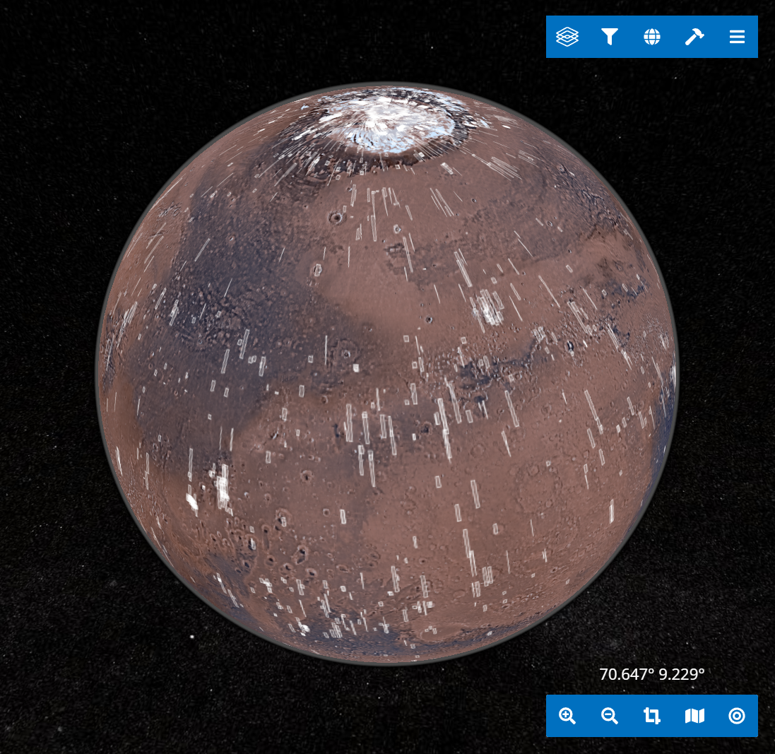
Figure 1: User interface of the multi-temporal database showing the intersections of CTX images with a temporal distance of 7 days (white polygons). Areas with a high temporal coverage, e.g., the pole regions as well as selected observation sites are ideal to study short-term surface changes, e.g., expansion and retreat of the seasonal surface ice and frost.
A key feature of the multi-temporal database is the intersection tool, that visualizes the intersection areas of overlapping images (Fig. 1). Based on user-defined parameters, such as datasets and the time interval between overlapping images, users are able to identify the spatial intersections on top of the global base maps. High-resolution previews as well as metadata, including e.g., download links of multi-temporal images provide the basis for diverse analyses of short- or long-term surface changes and processes.
The timeline tool is another key feature to explore the multi-temporal coverage of planetary surfaces. Images within an area of interest can be displayed in chronological order, allowing a quick overview of data availability and temporal context. Amongst others, it can be used to identify an overlapping dataset with the smallest or the longest time-interval (Fig. 2).
In addition to data identification tools the multi-temporal database offers a data processing service in order to facilitate the access to planetary image data. The processing service helps to reduce the amount of data as well as processing time by providing image data on demand, fitting to the user-defined research area and settings. After processing of the images which includes the calibration, georeferencing, and clipping of the images to the user-defined AOI, the processed images are available in a standard image file format (GeoTIFF).
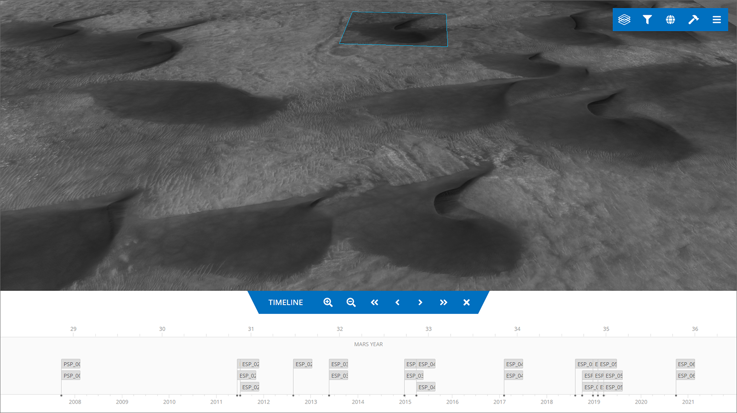
Figure 2: User interface of the multi-temporal database showing the temporal coverage of HiRISE images for a research area at Green Crater in the Noachis Terra region in the southern hemisphere of Mars. The timeline tool at the bottom reveals a good temporal coverage to analyze dune migration over several martian years.
Scientific applications:
The multi-temporal database enabled several studies on past and present-day changes of the surface of Mars [2-6]. In particular, the database has been used in recent projects on the contemporary activity of dark slope streaks [2-4] and martian gullies [5, 6]. Furthermore, the database has been used for data selection as a basis for geological mapping in several projects [e.g., 7, 8].
Acknowledgments:
This research has been funded and supported by the German Aerospace Agency (DLR) (Grant # 50 OO 2102).
References:
[1] Erkeling et al. (2016) PSS, 125, 43-61. [2] Heyer et al. (2018) PSS, 159, 56-65. [3] Heyer et al. (2019) Icarus, 323, 76-86. [4] Heyer et al. (2020) Icarus, 351, 113951. [5] Raack et al. (2020) Icarus, 350, 113899. [6] Sinha et al. (2020) Icarus, 352, 113979. [7] Bernhardt et al. (2019) PSS, 321, 171-188. [8] Cairns et al. (2020) LPSC 51, #1929.
How to cite: Heyer, T., Hiesinger, H., Iqbal, W., and Schmedemann, N.: The Multi-Temporal Database of Planetary Image Data (MUTED): A Web-Tool to Support Surface Change Analyses on Mars, Moon, and Mercury, Europlanet Science Congress 2022, Granada, Spain, 18–23 Sep 2022, EPSC2022-428, https://doi.org/10.5194/epsc2022-428, 2022.