
Detection of sediment transport in Kraken Mare with a radiative transfert model using an aerosol vertical profile and optical properties adapted to Titan North pole
 1,2,3
1,2,3- 1LATMOS,CNRS,Guyancourt, France (maelie.coutelier@latmos.ipsl.fr)
- 2GSMA,Université de Reims Champagne-Ardenne, Reims, France
- 3LPG, Université de Nantes, Nantes, France
Introduction
With 13 years of observations, the Visual And Infrared Mapping Spectrometer (VIMS) onboard the \textit{Cassini} spacecraft has observed the surface and atmosphere of Titan through two seasons: winter and spring. In VIMS-IR spectra the surface is only seen in seven atmospheric windows due to the strong methane absorption. To retrieve the surface albedo we use radiative transfer (RT) models to compensate for the signal due to the atmosphere. Thanks to the lander Huygens, we have information about the optical properties of the aerosols above the equator that can be used in RT models. However, using the same aerosols vertical profile at high latitude doesn't work. With the help of the results of and Global Circulation Models and the Composite InfraRed Spectrometer onboard Cassini, we changed the aerosol vertical profile and optical properties in our RT model to better fit VIMS data at high latitude. While this model is not well constrained due to a lack of data, we manage to adjust the optical properties so our RT model based on Coutelier et al., (2021) retrieve surface albedo mostly between 0 and 1 instead of values crossing these boundaries like we had previously. It allow us to study with a RT model the shores and polar seas of Titan. We applied this new model on the same area of Kraken Mare in three consecutive VIMS cubes of the same flyby (subsequently named C1, C2 and C3). It allow us to validate our model on terrains with different albedo, and to notice an interesting feature in Kraken Mare that could be interpreted as sediment transport into the sea.
Adaptation of the aerosols optical properties and vertical profile
We decided to keep a 2 layers-based aerosol model, separated into haze and mist. We first changed the haze opacity vertical profile, using an exponential law : 
with the altitude of transition between mist and haze Ztr=70 km, and the scale height Hh=40 km. τh1µm is the opacity calculated by Doose et al., 2016 at 1 µm. We then changed the spectral slope of the optical depth of the mist with a simple power law as a first approximation :

with Δτmnorm the normalized optical depth of the atmospheric layer of mean altitude z, τhλ0 the total optical depth at λ0 = 1 µm calculated by Doose et al 2016., λ the wavelength, and the parameter b = 2.2 +/- 0.2
The most influent parameter is the mist single scattering albedo ωm. we decided to change it depending on that of the haze ωh and a factor α = 0.4 +/- 0.1.

Application and results on Kraken Mare
We tuned and applyed this model on three successive VIMS cubes (full names in Fig. 1) subsequently called C1, C2 and C3. We retrieved the albedo on a zone crossing Kraken Mare, containing pixels from land, shore and methane sea. They are circled in red in Fig.1. The top part shows the VIMS cubes, and the bottom part their footprint on the geomorphologic map of Titan. That way we can have an expectation on the retrieved albedo: dark in the sea, and bright on land.
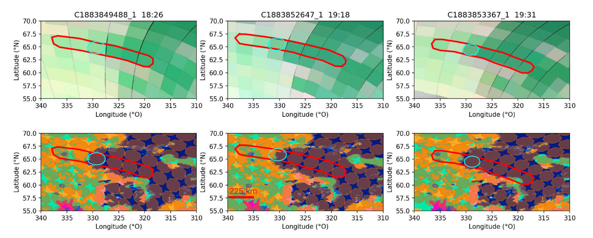
Figure 1 : (top) Successive VIMS cubes from flyby 292TI (colors : R : 5.01, V : 1.28, B : 2.79 μm).(bottom) : Footprint of the VIMS pixels on the geomorphologic map from Lopez et al., 2020. The pixels in our study are circled in red. The pixels circled in blue have mixed signatures.
The retrieved albedo are on Fig. 2. We still have remaining problems with negative albedo on dark pixels, mostly in the first atmospheric window. We can still differentiate very well the signatures from different terrains. Those coming from Kraken Mare are in blue, and those coming from the land are in green in Fig. 2. In C2, we have a pixel localized on the shore containing part of land and sea, circled in pink. Its signature is mixed, as we expected. However, we notice that on C1 and C3, two pixels localized in Kraken Mare (also circled in pink) also have a mixed signature. We did check that it was not a mistake in the cube geolocalization, or a difference due to a cloud.
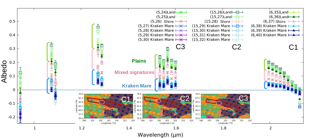
Figure 2 : Retrieved albedo of the selected pixels in Fig. 1. from the cubes C1, C2 and C3. The errors bar are calculated from the error on VIMS, and not from the error on the model. They are underestimated as a consequence.
Discussion
Infrared can penetrate deeply into liquid methane and ethane. The mixed signature we noticed can come from sediment transport carried by rivers flowing into Kraken Mare, issued from the erosion of the bedrock.
While this aerosol model for the poles is not exact, nor well constrained, the RT model is working and gives reasonable results on different cubes from the same flyby. We can compare the different surface albedos instead of the absolute values, because the atmospheric model is the same for all of the studied pixels. The combination of the RT analysis with the geomorphologic map is a powerful tool that leads to notice unexpected signatures.
With the seasons changes, we can expect that the improved polar aerosol model is not constant, so further studies should be made on other cubes through different seasons. We could that way follow through an other method the seasonal variation of the polar haze and mist layers.
References
Doose et al. (2016) Vertical structure and optical properties of Titan’s aerosols from radiance measurements made inside and outside the atmosphere. Icarus 270 : 355-375.
Coutelier et al. (2021) Distribution and intensity of water ice signature in South Xanadu and Tui Regio. Icarus 364 : 114464.
Lopes et al. (2020) A global geomorphologic map of Saturn’s moon Titan." Nature astronomy 4.3 : 228-233.
How to cite: Coutelier, M., Rannou, P., Cordier, D., and Seignovert, B.: Detection of sediment transport in Kraken Mare with a radiative transfert model using an aerosol vertical profile and optical properties adapted to Titan North pole, Europlanet Science Congress 2022, Granada, Spain, 18–23 Sep 2022, EPSC2022-449, https://doi.org/10.5194/epsc2022-449, 2022.