
Classification of Mercury’s Impact Basins, Based on Topography- and Gravity Signatures in MESSENGER Data
- 1Technical University of Berlin, Institute of Geodesy and Geoinformation , Planetary Geodesy, Germany (claudia.szczech@dlr.de)
- 2German Aerospace Center (DLR), Berlin Adlershof, Institute of Planetary Research
Introduction
Mercury’s surface is characterized by large and well-preserved impact basis. They represent important records regarding the magnitude and timing of the “Late Heavy Bombardment” in the early inner solar system. It has been suggested that Mercury and Moon had the same early impactor population based on their similar crater size frequency distributions [1,2]. In this study we investigated the basins using complementary topography and gravity data sets derived by MESSENGER [3,4]. Gravitational data in combination with the surface morphology of the basins may help improve our understanding of their formation processes and alterations with time. Gravity anomalies hint at complex interior structures, such as mass and density distributions in the upper crust of the planet, which is beneficial for identifying highly degraded or buried basins.
In this study, we present an inventory of basins larger than 150 km, for which we introduce a classification scheme according to morphological and gravitational signatures.
Methods and data sets
The topographic digital terrain model (DTM) used in this study was derived by the Mercury Dual Imaging System (MDIS), involving a narrow-angle- as well as a wide-angle camera [3]. Gravity data data of the MESSENGER spacecraft, which resulted in a gravity field model with a resolution of degree and order 160, equivalent to approximately 28 km in the spatial domain [4].
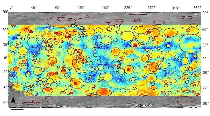

Fig 1: DTM of Mercury’s topography. Circles mark the identified basins.
Results
Our preliminary basin inventory hosts 311 basins (Fig.1). A clear correlation is noticed between the topography and gravity data, in particular impact basins are well detectable in both data sets. Their global distribution is non-uniform. Around 60% of basins are located on the western hemisphere. This asymmetric pattern may be caused by (I) lateral thermal variances of the crust [1], (II) synchronous spin- and orbital periods of the planet in its early history, which later changed to its presently observed 3:2 spin-orbit resonance [2], (III) resurfacing events that includes the northern smooth plains and following flooding of existing basins on the eastern hemisphere, which would eventually bury smaller complex basins.
With increasing diameter basins were found to show more complex gravity- and topography signatures. Basins with smaller diameter (<160 km) display a central peak. With increasing size, the morphology changes to a peak ring in the center. The transition from peak ring to multi-ring basins is suggested to occur at 350 km as is attested by a distinct change in the gravitational signal. The gravity disturbance remains mostly in strong negative values. This value shifts to a positive one for basins larger than 350 km.
High positive gravity signals were also recognized in the Bouguer anomaly map. Some basins (>350 km) possess a positive Bouguer anomaly in the basin center surrounded by a negative anomaly annulus (bullseye pattern) (Fig 2). Gravity data are reflecting mass/density deficits and excesses in the planet’s subsurface structures. The high mass and density concentrations may be caused by an uplift of mantle material after the crater excavation phase [5]. The excavation was followed by an isostatic adjustment caused by cooling and contraction of the melt pool. Subsequently, crust is expected to be thinner.

Fig 2: Left: Profile of Bouguer anomaly, Right: Bouguer anomaly map; showing positive strong anomaly in center surrounded by negative annulus.
However, basins with small diameter (<200 km) were found to show strong positive anomalies as well, that indicate a mantle uplift after their formations. Due to limited data resolution (particularly in the south) the localization and accuracy of the Bouguer anomalies is not certain.
Other 208 basins where identified, but could not be characterized in detail due to their high degradation state (rim <50%). Most of these are filled by secondary material. Future data with improved resolution would be required to verify these results.
We investigated the amplitude of Bouguer anomalies in the basin centers and surroundings as a measure of crustal thinning, which may hint at basin relaxation state. Lunar observations showed, that young basins with large diameters should contain strong positive anomalies because of limited relaxation due to high viscosity of a cooler planet [6]. In contrast, a less pronounced gravity anomalies hint at higher relaxation due to lower viscosity and a hotter crust in the planet’s earlier history (Fig 3).

Fig. 3: Bouguer anomaly contrast from rim to centre versus rim diameter. Basin classes: b_deg- degraded basin (<50% rim preserved), centr_peak- central peak basin, peakr- peak ring basin, com- complex basin (>50% rim preserved).
Acknowledgements
This work is supported by the Deutsche Forschungsgemeinschaft (SFB-TRR170, A6).
References
[1] Orgel et al., 2020, Re-examination of the Population, Statigraphy and Sequence of Mercurian Basins: Implications for Mercury’s Early Impact History and Comparison with the Moon, J. Geophys. Res. 125(8), doi:10.1029/2019JE006212
[2] Fassett C. I., et al., (2012), Large impact basins on Mercury: Global distribution, characteristics, and modification history from MESSENGER orbital data, J. Geophys. Res. 117, E00L08, doi:10.1029/2012JE004154
[3] Preusker et al., Towards high-resolution global topography of Mercury from MESSENGER orbital stereo imaging: A prototype model for the H6 (Kuiper) quadrangle, Planetary and Space Science 142 (2017) 26-37
[4] Konopliv et al., The Mercury gravity field, orientation, love number, and ephemeris from the MESSENGER radiometric tracking data, Icarus, Volume 335, 2020, 113386, ISSN 0019-1035,https://doi.org/10.1016/j.icarus.2019.07.020.
[5] Wieczorek, M., The gravity and topography of terrestrial planets, Treatise on geophysica, 2006
[6] Neumann et al., 2015. Lunar impact basins revealed by Gravity Recovery and Interior Laboratory measurements. Science Advances 1(9), 1-10.
How to cite: Szczech, C. C., Oberst, J., and Preusker, F.: Classification of Mercury’s Impact Basins, Based on Topography- and Gravity Signatures in MESSENGER Data, Europlanet Science Congress 2022, Granada, Spain, 18–23 Sep 2022, EPSC2022-595, https://doi.org/10.5194/epsc2022-595, 2022.