
The Europa Imaging System (EIS): High-Resolution, 3-D Insight into Europa’s Geology, Ice Shell, and Potential for Current Activity
 2,
2,- 1Johns Hopkins Applied Physics Lab., Laurel, Maryland, United States of America (elizabeth.turtle@jhuapl.edu)
- 2Univ. Arizona, Tucson, Arizona, United States of America (mcewen@lpl.arizona.edu)
- *A full list of authors appears at the end of the abstract
Abstract
The Europa Imaging System (EIS; Fig. 1) for NASA's Europa Clipper Mission combines a narrow-angle camera (NAC) and a wide-angle camera (WAC) to explore Europa and address high-priority geology, composition, ice shell and ocean science objectives. Both cameras have framing and pushbroom imaging capability, including broadband color filters. EIS data will be used to generate: cartographic and geologic maps; regional and high-resolution topography; GIS, color, and photometric data products; a database of plume-search observations; and control points tied to radar altimetry. Our science goals are to:
- constrain the formation processes of landforms by characterizing geologic structures, units, and global cross-cutting relationships;
- identify relationships between surface and sub-surface structures and potential near-surface water detected by ice-penetrating radar;
- investigate compositional variability between and among landforms and correlate composition be-tween individual features and regional units;
- search for evidence of recent or current activity, including potential erupting plumes;
- constrain ice-shell thickness from global shape measurements via limb fits;
- characterize surface clutter (off-nadir surface reflections that may appear to be subsurface interfaces) to aid interpretation of deep and shallow radar sounding;
- characterize scientifically compelling landing sites and hazards by determining the nature of the surface at meter scales.
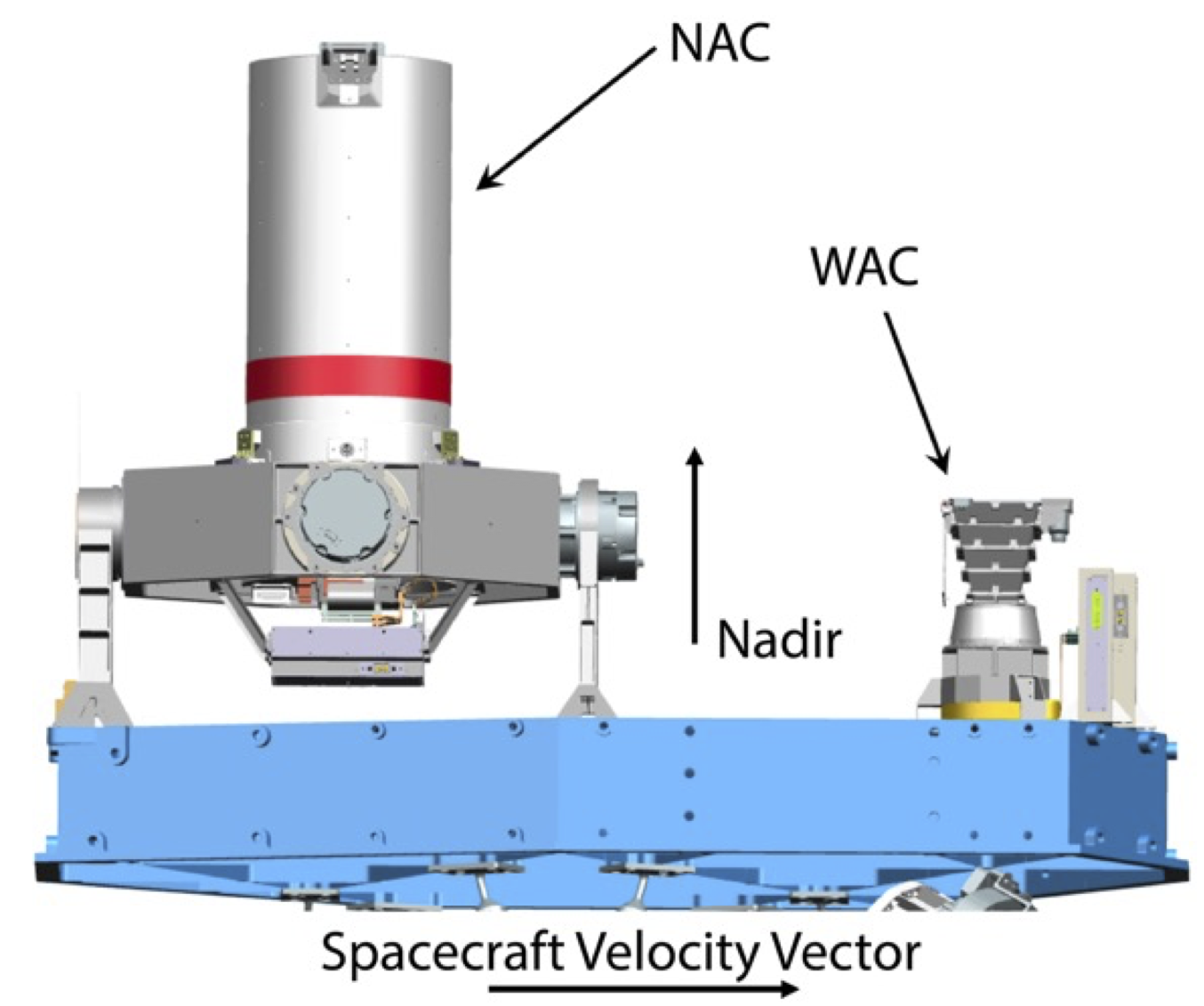
Figure 1: EIS NAC (left) and WAC (right) on the spacecraft nadir deck. The NAC is mounted on a 2-axis gimbal. The DPUs are in the spacecraft vault.
EIS Narrow-angle Camera (NAC)
The NAC has a 2.3° x 1.2° field of view (FOV) with a 10-μrad instantaneous FOV (IFOV), and from an altitude of 50-km achieves 0.5-m pixel scale over a 2-km-wide swath. Its 2-axis gimbal, ±30° cross- and along-track, enables targeting independent of spacecraft orientation, allowing near-global (>90%) mapping of Europa at ≤100-m pixel scale (to date, only ~14% of Europa has been imaged at ≤500 m/pixel), as well as regional stereo imaging. The gimbal slew rate is designed to be able to perform very high-resolution stereo imaging from as close as 50-km altitude during high-speed (~4.5 m/s) flybys to generate digital topographic models (DTMs) with ≤4-m ground sample distance (GSD) and ≤0.5-m vertical precision. The NAC will also perform high-phase-angle observations to search for potential erupting plumes; a pixel scale of 10 km from 106 km range means that the NAC can take advantage of good illumination geometry for forward scattering by potential plumes even when the spacecraft is distant from Europa.
EIS Wide-angle Camera (WAC)
The WAC has a 48° x 24° FOV with a 218-µrad IFOV, and is designed to acquire 3-line pushbroom stereo and color swaths along flyby ground-tracks. From an altitude of 50 km, the WAC achieves 11-m pixel scale over a 44-km-wide swath, generating DTMs with 32-m GSD and 4-m vertical precision. These data also support characterization of surface clutter for interpretation of radar deep and shallow sounding.
Detectors and Electronics
The cameras have identical rapid-readout, radiation-hardened 4k x 2k CMOS detectors and can perform both pushbroom and framing imaging. Color observations are acquired by pushbroom imaging using six broadband filters (Table 1; Fig 2), allowing mapping of surface units and correlation with geologic structures, topography, and compositional units from other instruments. Radiation-hard data processing units (DPUs) take advantage of the CMOS rapid, random-access readout and use real-time processing for pushbroom imaging, including: WAC 3-line stereo, digital time delay integration (TDI) to enhance signal-to-noise ratios (SNR), and readout strategies to measure and correct jitter.
Table 1: NAC and WAC broad-band, stripe filters
|
Filter |
Wavelength (nm) |
Key Uses |
|
Clear |
NAC: 350–1050 WAC: 370–1050 |
Mapping, stereo, context imaging, best SNR for faint targets, e.g., plume searches |
|
NUV |
NAC: 355–400 WAC: 375–400 |
(See Figure 2) |
|
BLU |
380–475 |
(See Figure 2) |
|
GRN |
520–590 |
(See Figure 2) |
|
RED |
640–700 |
(See Figure 2) |
|
IR1 |
780–920 |
(See Figure 2) |
|
1µm |
950–1050 |
(See Figure 2) |
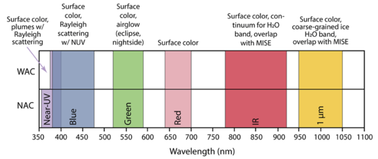
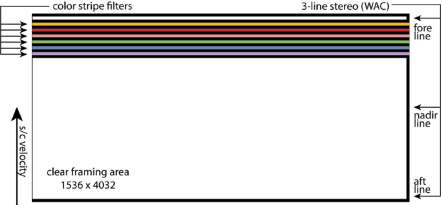
Figure 2: EIS broadband filter wavelengths (top) and WAC filter layout (bottom).
Summary
EIS data sets and collaborative science with other investigations will provide insight into Europa’s global geology, ice shell, and the potential for recent or current activity, to fulfill the goal of exploring Europa to investigate its habitability. Updates will be provided on flight instrument performance from ground testing and expected datasets from the planned tour at Jupiter.
E. P. Turtle, A. S. McEwen, G. W. Patterson, M. Bland, G. C. Collins, P. Corlies, I. J. Daubar, C. Detelich, C. Elder, C. M. Ernst, L. Fletcher, C. J. Hansen, S. E. Hawkins, A. G. Hayes, C. Haslebacher, D. Humm, T. A. Hurford, R. L. Kirk, N. Kutsop, J. McDermott, H. Meyer, A. C. Barr Mlinar, J. Niewola, F. Nimmo, C. B. Phillips, A. Pommerol, L. Prockter, L. C. Quick, K. A. Slack, H. Seifert, J. M. Soderblom, A. Stickle, S. Sutton, N. Thomas, O.J. Tucker
How to cite: Turtle, E. and McEwen, A. and the EIS Team: The Europa Imaging System (EIS): High-Resolution, 3-D Insight into Europa’s Geology, Ice Shell, and Potential for Current Activity, Europlanet Science Congress 2022, Granada, Spain, 18–23 Sep 2022, EPSC2022-598, https://doi.org/10.5194/epsc2022-598, 2022.