
 1,1,1
1,1,1- 1Freie Universität Berlin, Department of Earth Sciences, Institute of Geological Sciences, Planetary Sciences Working Group, Berlin, Germany (sebastian.walter@fu-berlin.de)
- 2Institute of Planetary Research, German Aerospace Center (DLR), Berlin, Germany
Introduction
While the single image coverage of the currently available Context Camera (CTX, [1]) images converges to the full coverage of the surface of Mars, the individual images show offsets of tens to hundreds of pixels from their real ground position. Current efforts for ortho-rectification and lateral control use the MOLA data as a source for global reference and geometric correction (e.g., [2]). Towards the equator this approach is unprecise due to the large discrepancy of the spatial resolutions of the two datasets (6 m/px vs.463 m/px). Automatic point matching of image pixels to DTM pixels are not reliable, therefore usually the CTX pixels are matched to imagery datasets which are themselves controlled to MOLA, such as the THEMS IR dataset [3]. This of course is sensitive to error propagation. The HRSC team expects to finalise the creation of global mosaics consisting of bundle-block-adjusted DTMs and their corresponding image mosaics [4] by the end of the year 2023. These DTMs provide an internal photogrammetric precision better than the 50 m used as the grid size. The deviations from the MOLA profile heights are also less than this single pixel resolution value [5]. Their corresponding image mosaics provide precise pixel-by-pixel alignment to the respective DTM in 12.5 m/px resolution [6]. Here we show a first approach using these HRSC products as the global reference dataset for Mars, by creating a CTX quadrangle mosaic with absolute geodetic control to HRSC (and therefore also to MOLA).
Methods
Generally, first the HRSC DTM is used for the ortho-rectification of the CTX images instead of MOLA. After this geometric correction, the image mosaic is used as a reference for automatic point matching and co-registration. We then apply the well-established brightness correction in a similar way we are using it for HRSC [6]. Ultimately, we combine the multitude of images from a whole quadrangle together to a seamless mosaic and export it as a single image file. The general workflow of our processing pipeline is shown in Fig. 1.

Figure 1: Flow chart of the proposed CTX processing workflow from single images to a complete mosaic.
Owed to the large amount of single CTX images per HRSC tile, we use a database management system (DBMS) for storage and retrieval of the CTX data catalog. In the spatially-enabled DBMS we perform geometric queries by intersection with the HMC30 boundary with the CTX footprints. The map-projection and co-registration of the data is slow - processing time can be significantly increased by high-performance computing (HPC). We define the main tasks as array jobs: The ISIS [7] processing pipeline performs image ortho-rectification using the HMC30 DTM. The resulting nominally ortho-rectified CTX images show a significant offset to HRSC based on inaccurate spacecraft attitude control (see Fig. 2 left). For correction, we introduce a subsequent co-registration based on a phase correlation approach [8]. The consecutive brightness correction uses the same HRSC image mosaic as a radiometric reference. A final step for seamline creation and image export is performed outside of the cluster using Desktop GIS software.
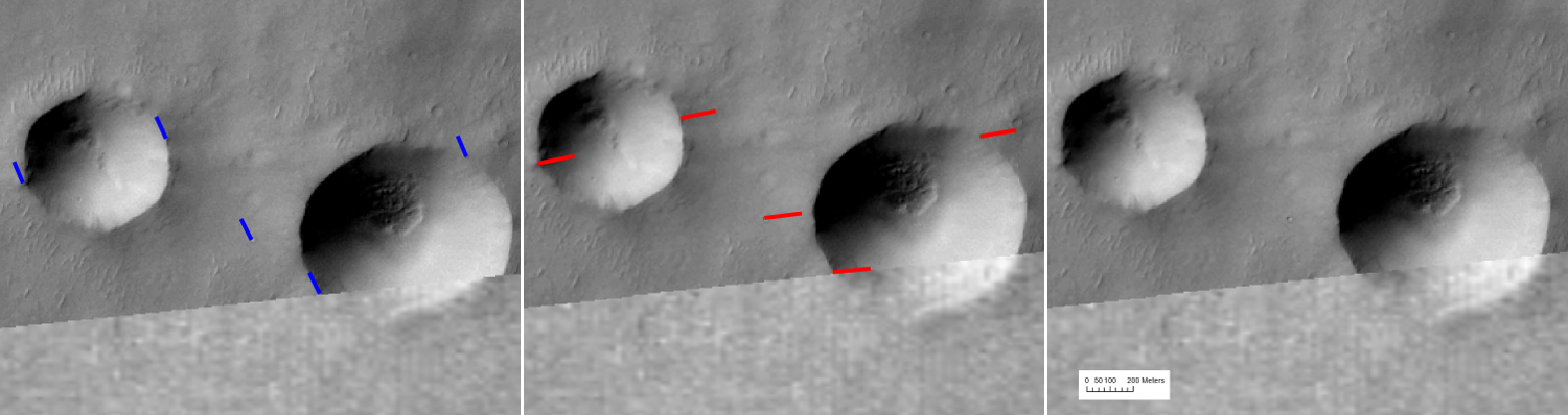
Figure 2: Image offsets between CTX image D02_027799_1580 (6.25 m/px) and HRSC HMC30 20W (12.5 m/px); left: CTX with nominal pointing after ISIS standard processing, offsets in red; middle: CTX co-registered to HRSC by global x/y shift, offsets in blue; right: CTX co-registered by warping to dense network of tie points, no visible offsets.
Results
In a first qualitative assessment of dividual single CTX images, we examined the pixel offsets between the nominal images and their co-registered counterparts. First we tried to translate the images only in x/y direction as a block, but there were significant remaining offsets, increasing in the along-track direction of the spacecraft (see Fig. 2 middle). We achieved better results by transforming the CTX image to the HRSC reference image by the use of a dense network of tie points (see Fig. 2 right). In the example given in Figure 2, the offsets measure about 170 m which corresponds to 27 CTX pixels, 13 HRSC image pixels and 3 HRSC DTM pixels. Based on the processing pipeline described above, we created a complete CTX mosaic of the HMC-20W quadrangle, which will be available on our mapserver (https://maps.planet.fu-berlin.de). The ISIS processing steps were successfully applied to all of the 2062 images intersecting the DTM boundary, and 1692 of the images were successfully co-registered to the HMC30 image mosaic. The processing of the complete CTX dataset consisting of 2062 single images with a resolution of 6.25 m/px took around 3 days on the cluster, but this time is highly dependent on the cluster utilization.
Discussion
The results of the co-registration with a success rate of 82% are better than we initially expected. The remaining visible image gaps might be filled either by adapted parameters for co-registration or by the addition of manual tie-points. The initial offsets between the nominally-processed CTX images and the HRSC DTM (3 pixels in our example) might be large enough to expect impacting geometric artifacts during the orthorectification process, which will not be removed by the co-registration. Therefore it is planned to include an additional iterative processing step by feeding the tie-points acquired from the co-registration back into the ISIS pipeline and perform a bundle-adjustment between the CTX image and HRSC as ground and height reference.
Acknowledgements
This work is supported by the German Space Agency (DLR Bonn), grant 50OO2204, on behalf of the German Federal Ministry for Economic Affairs and Climate Action. We thank the HPC Service of FU for computing time [9].
References
[1] M. C. Malin et al., JGR Planets (E5 2007). [2] J. L. Dickson et al., LPSC 49, #2480. [3] S. J. Robbins et al., LPSC 52, #2066. [4] K. Gwinner et al., EPSC/DPS 13, 2019, #2006. [5] K. Gwinner et al., PSS 126 (2016). [6] G. G. Michael et al., PSS 121 (2016). [7] T. Sucharski et al. (2020), DOI: 10.5281/zenodo.3962369. [8] Q. Chen et al., IEEE TPAMI 16 (1994), pp. 1156–116. [9] L. Bennett et al. (2020), DOI: 10.17169/refubium-26754.
How to cite: Walter, S. H. G., Neesemann, A., Gwinner, K., Michael, G. G., Jaumann, R., and Postberg, F.: Coregistering Mars Reconnaissance Orbiter Context Camera Images to Mars Express High Resolution Stereo Camera Global Datasets, Europlanet Science Congress 2022, Granada, Spain, 18–23 Sep 2022, EPSC2022-601, https://doi.org/10.5194/epsc2022-601, 2022.