
Assessing the detectability of subsurface events beneath Europan multi-ring basins with an interferometric radar sounder: Test-simulations on a Martian crater
 1,1,
1,1,- 1University of Texas at Austin, Institute for Geophysics, Austin, United States of America (christopher.gerekos@austin.utexas.edu)
- 2Jet Propulsion Laboratory, California Institute of Technology, California, USA
1. Introduction
The Jovian icy moon Europa will be the target of the Europa Clipper mission, which carries the REASON instrument, a dual-frequency radar sounder.
Radar sounders operate by emitting electromagnetic waves towards a solid planetary body and by recording subsequent reflections of these waves from discontinuities of the dielectric constant, which confers them the capability to image subsurface features. As radar sounders are sensitive to the delay of echoes, a major issue these instruments have to overcome is the problem of discriminating a genuine subsurface feature from a surface feature located away from nadir at an equivalent delay (i.e. clutter).
The REASON instrument will have the capability to use interferometric clutter discrimination in its VHF component (f=60 MHz). This is enabled by the presence of four radiating elements, forming two independent groups of two antennas, L and R, separated by a baseline (see Fig. 1). By comparing the phase of a features in the L and R signals, it is possible to determine, under certain conditions, if the feature is a subsurface reflector at nadir of if it originates from a non-nadir position on the surface [Castelletti et al., TGRS, 2017][Haynes et al., TGRS, 2021].
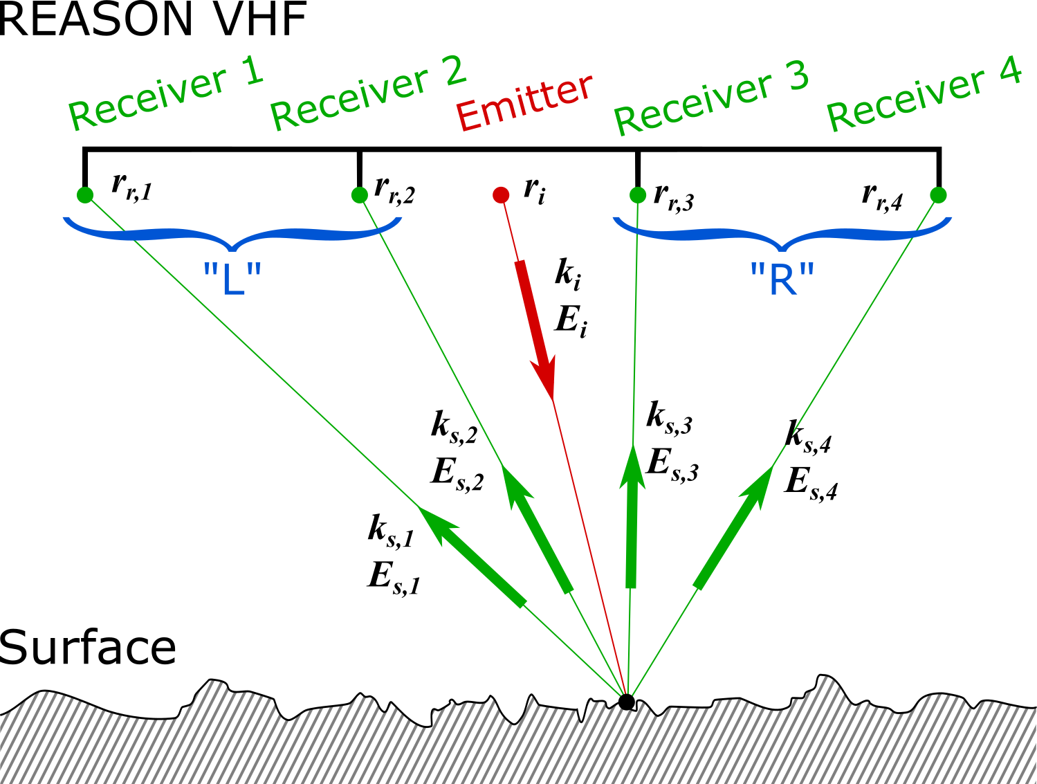
Fig. 1 - Schematic representation of the REASON VHF interferometric scattering geometry as implemented in the simulator.
On Europa, features known as multiring basins are of particular interest to the planetary science community as their formation depends on the thickness and structure of Europa's ice shell at the time of the impact, and are foreseen to be studied by REASON. However, the clutter environment they represent is likely to be challenging, which warrants having a good prior understanding of how clutter will interact with possible subsurface targets.
To predict the detectability of subsurface targets in the presence of such a unique clutter environment, we will make use of an advanced Stratton-Chu simulator, which has the capability to consider subsurface layers or large inclusions, subwavelength roughness on the DEM (digital elevation model) facets, and which we have generalised to multiantenna sounders with interferometric capabilities such as REASON. The multilayer aspects have been described in [Gerekos et al., TGRS, 2018][Gerekos et al., IGARSS, 2018] whereas the rough facet generalisation has been outlined in [Gerekos et al., IGARSS, 2022 (accepted)]. In this abstract, we present simulation results over a Martian crater, discuss possible clutter models for Europan ridged terrain, and how the capabilities of such a simulator could be leveraged to have a precise understanding of REASON's capabilities over these landforms.
2. Simulations over a Martian crater
As all four antennas fire at once, we consider the emitter to be a fictional point at the centre of the VHF array (see Fig. 1). The receivers are located at the four different antennas, and the echoes are simulated for each antenna, making use of the bistatic formulation on which [Gerekos et al., TGRS, 2018][Gerekos et al., IGARSS, 2018] is based. The fields received at each pair of antennas are combined into an L and R signal as described above. The considered REASON altitude in this test is 50 km.
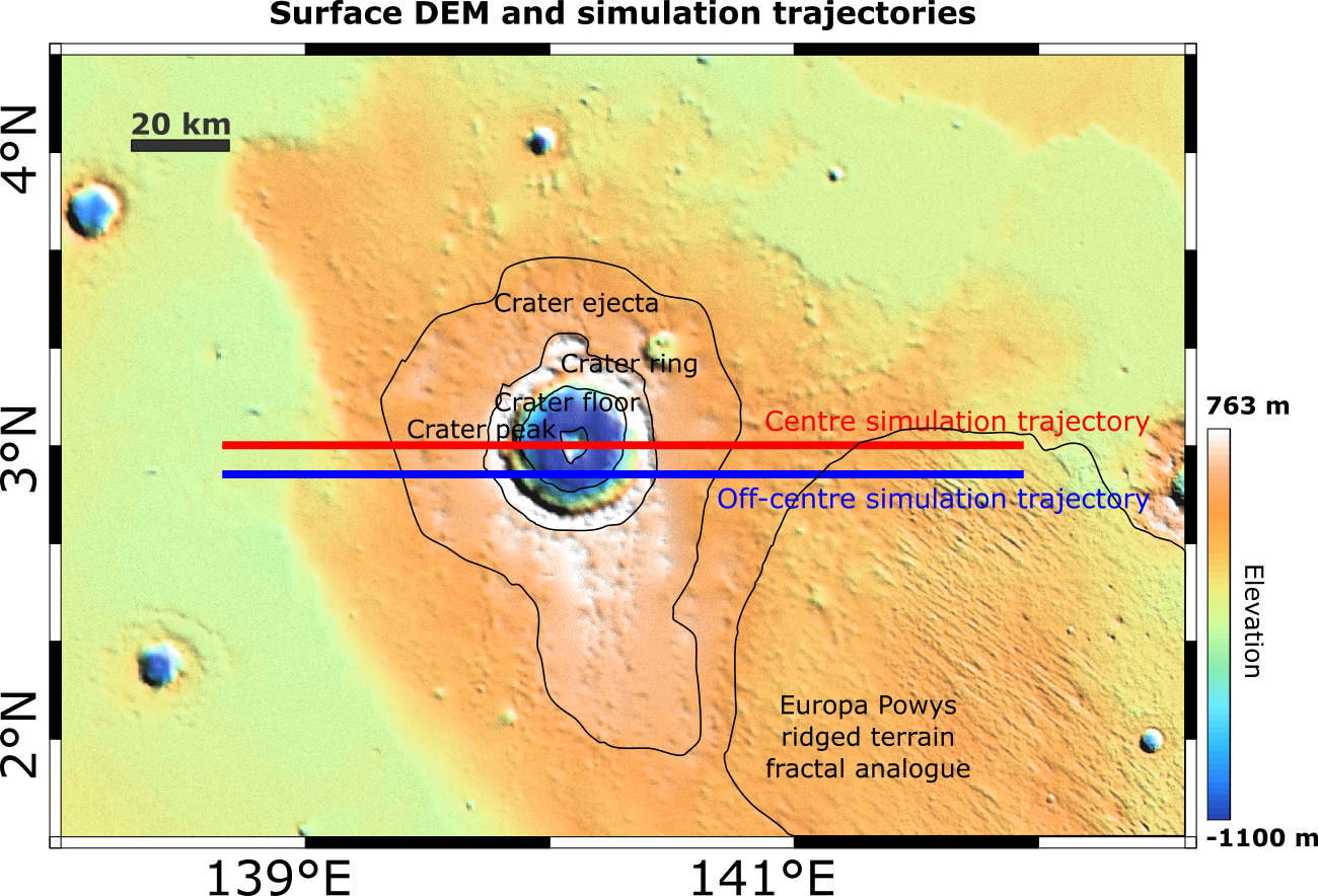
Fig. 2 - MOLA-HRSC DEM (200m resolution) of a crater in Aeolis Planum, Mars, with some geologic units shown as black outlines, and the simulation trajectories as the red and blue lines.
The DEM we used is that of highly circular a peaked crater in Aeolis Planum surrounded by a Europa Powys ridged terrain fractal analogue [Gerekos et al, Icarus, 2021], Mars, and is shown in Fig. 2. Two simulations are conducted: one going through the centre of the crater and one having a slight offset to the South. A uniform small-scale roughness of σ=1m, l=60m is considered on the DEM facets.
The centred and off-centre simulation results are shown in Figs. 3 and 4, respectively. The surface on either side of the crater has an unambiguously zero intereferometric phase as expected, whereas the echoes from further off-nadir in the ridged area show a distinctive non-zero phase difference, showing that the interferometric clutter discrimination is having the expected effect in the simulation. Likewise, clutter echoes around the crater area can be identified and separated from the otherwise identical-looking floor echo. Comparing the two tracks, we can see how introducing asymetry within the sounding geometry can lead to potentially easier clutter discrimination, at least when it comes to the crater ring.
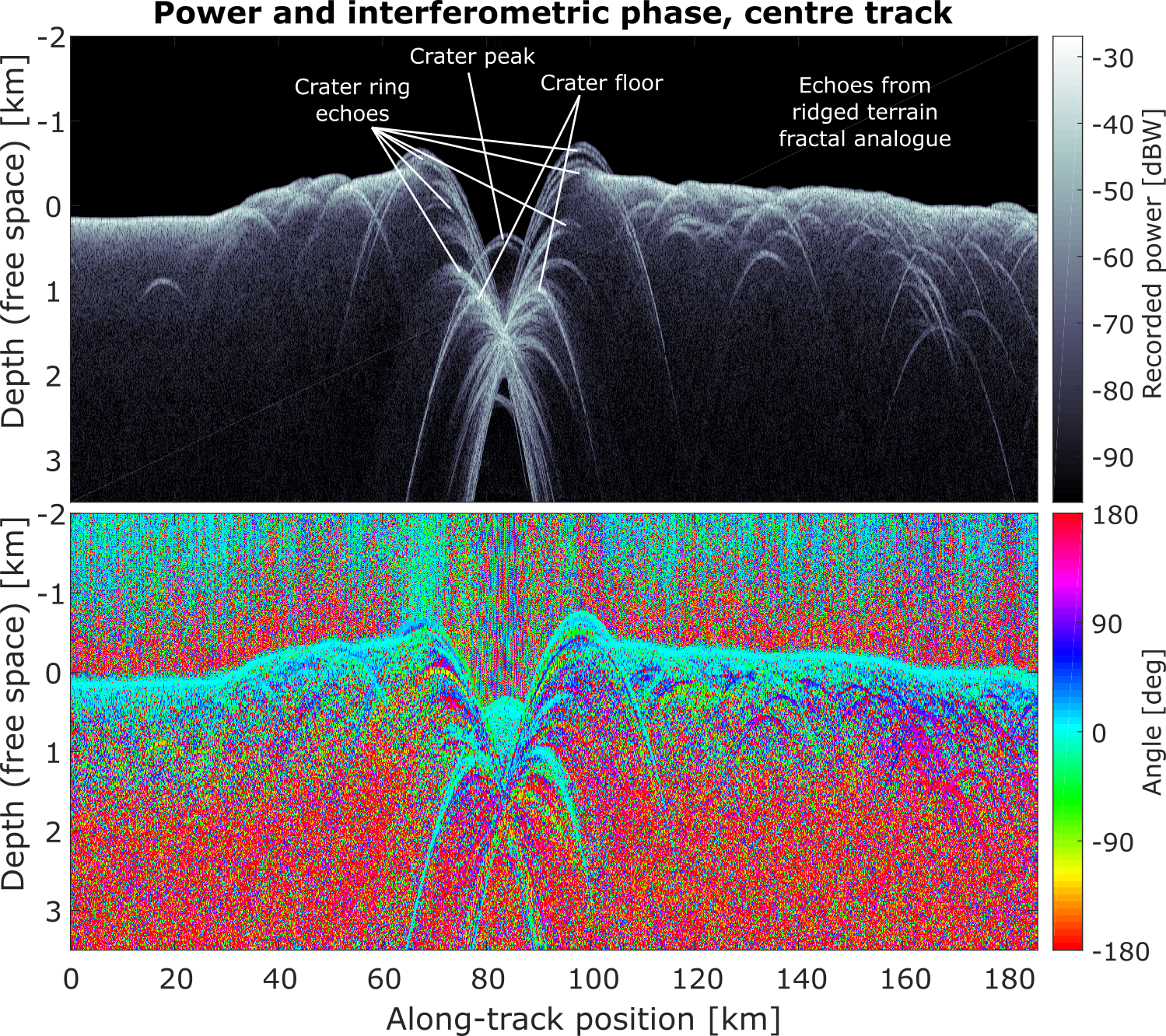
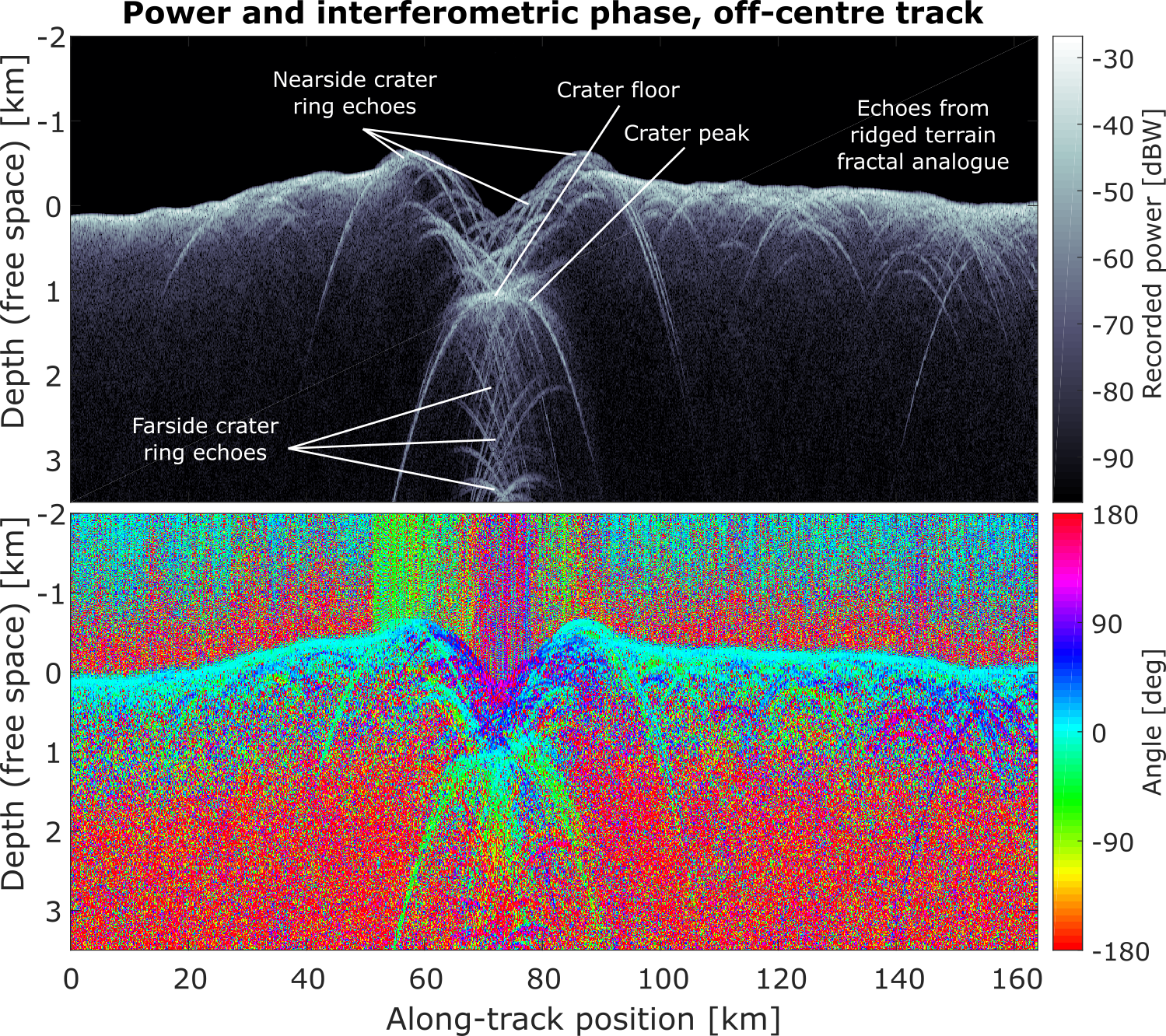
Figs. 3 and 4 - Intereferometric simulations results for the "centre" (left) and "off-centre" (right) scenarios depicted in Fig. 2. The top image represents the backscattered power from all channels combined, PL + PR, whereas the bottom one represents the difference between the phase two channels, <φL - <φR.
3. Towards multiring basin clutter environment description
Multiring basins are thought to be formed by the impact of massive projectiles. During the collapse of the initial crater, low-viscous ice, or even water, at depth would flow towards the center, filling the gap left by material excavated from the impact. As the overlying crust is pulled inward, normal faults form, shaping the characteristic concentric rings around the basin's center. A depiction of the geological units of such basins is shown in Fig. 5. The two prominent multiring basins on Europa, Tyre and Callanish, have both diameters around 35 km. Their dimensions, flank slopes, and roughness have been estimated in the literature [Moore et al., Icarus, 1998].
As future work, we plan to construct realistic DEMs of these landforms in order to use our simulator to predict REASON's capability to image subsurface events in presence of such a clutter environment. Leveraging the rough facets modelisation capability of the simulator, we will also be able to consider different subwavelength roughness levels to add to the different geological units of a multiring basin (σi, li in Fig. 5), in addition to its topography, leading to a very complete clutter characterisation.
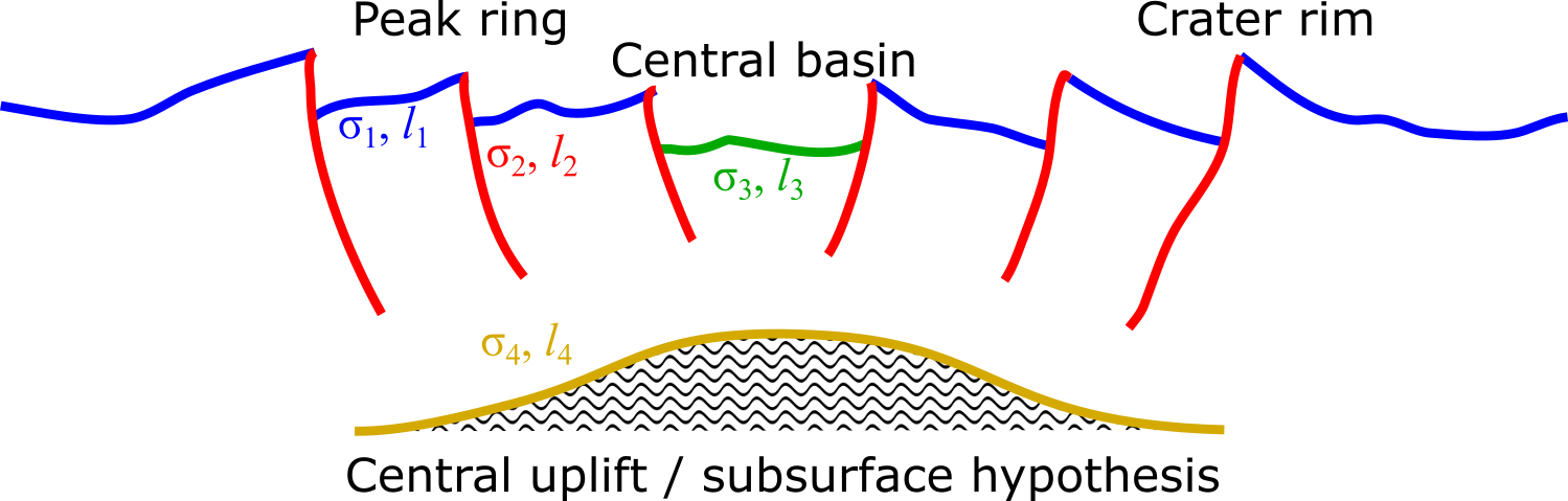
Fig. 5 - Schematic of a multiring basin that will be the basis for smulations of interferometric clutter discrimination over these objects.
How to cite: Gerekos, C., Steinbrügge, G., Haynes, M., Young, D., and Blankenship, D.: Assessing the detectability of subsurface events beneath Europan multi-ring basins with an interferometric radar sounder: Test-simulations on a Martian crater, Europlanet Science Congress 2022, Granada, Spain, 18–23 Sep 2022, EPSC2022-661, https://doi.org/10.5194/epsc2022-661, 2022.