- 1University College London, Mullard Space Science Laboratory, Department of Space and Climate Physics, United Kingdom of Great Britain – England, Scotland, Wales (ucasate@ucl.ac.uk)
- 2NASA Jet Propulsion Laboratory, California Institute of Technology, Pasadena, California, USA
- 3Space Science Institute, Boulder, Colorado, USA
- 4Instituto Nacional de Técnica Aeroespacial, Mardrid, Spain
- 5Center for Research in Earth and Space Science, York University, Toronto, Canada
- 6NASA Headquarters, Washington DC, USA
Abstract
Using a variety of instruments onboard the Perseverance Rover, a substantial amount of data has been collected and analyzed to understand the environment and atmosphere of the landing site, Jezero Crater. A vital component in understanding this unique environment is studying the local and regional variations of water over diurnal and seasonal timescales. We specifically study the variations of water ice in the atmosphere by observing cloud activity over Jezero Crater using data collected by the Navigation Cameras, NavCam, on board the Mars2020 Rover, Perseverance.
Introduction
Water Ice clouds on Mars have been observed for a long time from both the surface and from orbit to understand the role of water in the atmosphere. Using Viking era data, Tamppari (2000, 2003) observed water ice clouds with peak activity seen during the northern spring and summer time. Opportunity Rover acquired images of water ice clouds during the Aphelion Cloud Belt (ACB) season with peak activity seen from Ls 50o to 115o (Lemmon et al., 2015). From the past activity, we have seen that between the solar longitude (Ls) of 45o to 150o, the Aphelion Cloud Belt (ACB) forms every Mars Year (MY) in the equatorial region (10oS–30oN). (Tamppari et al., 2000) (Smith et al., 2004)
Furthermore, the Surface Stereo Imager (SSI) on-board the Phoenix Lander showed a large variety of cloud types over the course of the 151-sol mission (Moores et al., 2010). The navigation camera, NavCam aboard the Mars Science Laboratory (MSL, Curiosity) rover has observed cloud activity at Gale crater through cloud movies and surveys. The diurnal and seasonal patterns were comparable with previous observations. The peak cloud activities were observed in the morning/afternoon time and around the ACB period. (Kloos et al., 2018) They have also been reported to leave a thermal signature at night on Gale’s surface (Cooper et al. 2021).
NAVCAM data
At Jezero Crater, water ice clouds have been observed through cloud movies and cloud surveys collected using the Perseverance NavCam instrument that collects colour stereo images with a 96ox73o field of view at 0.33 mrad/pixel. (Maki et al., 2020) Compared to the NavCam on Curiosity, the NavCam on Perseverance holds the capability of imaging in colour which may provide advantages in highlighting water ice clouds in the atmosphere.
Cloud surveys are single images taken facing the horizon, generally twice a week, at various times of the day. Similarly, cloud movies are collected by taking 8 frames of images looking towards the horizon with an interval of 15 seconds, producing a movie. A combination of cloud surveys and movies collected by the mission are used to study water ice clouds.
Data Processing
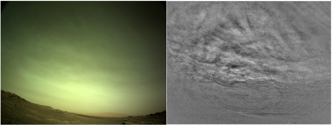
Various image processing techniques are used on these data sets to emphasize the presence of water ice clouds in the atmosphere. For example, the NavCam Cloud movies can be processed using an imaging technique known as Mean Frame Subtraction (MFS) to enhance cloud features (Campbell et al., 2020) (Moores et al., 2015). This technique takes the average frame of the whole movie and subtracts it from each frame (Moores et al., 2015). This reveals the time-variable component, displaying the cloud movement within the movie. Figure 1 shows an example of raw (left) versus MFS processed frames (right) of a NavCam cloud movie. In addition to these processed images and movies, we have explored techniques such as two-dimensional fast Fourier transforms to recognize patterns in clouds.

Figure 1: Comparison between raw and Mean Frame Subtraction frames. The raw frame (left) only shows faint clouds but when the Mean Frame Subtraction method is applied (right), the cloud features become visible.
We will be presenting the water-ice cloud activity at Jezero Crater with details on various image processing techniques used to determine the characteristics of Martian clouds. The full data set from the start of the Mars2020 mission up to now will be analyzed to determine any seasonal patterns in the cloud activity seen at Jezero.
Bibliography
Campbell et al., 2020. Planet. Space Sci. 182 104785, http://dx.doi.org/10.1016/j.pss.2019. 104785.
Cooper, B., et al., 221 JGR: Planets, 126(12), doi:10.1029/2020JE006737, 2021
Kloos et al., 2018. Geophys. Res. Planets. (2018)123, 233–245. https://doi.org/10.1002/2017JE005314
Lemmon et al., 2015. Icarus 251, 96–111. https://doi.org/10.1016
Moores et al., 2010. J. Geophys. Res. Planets. https://doi.org/10.1029/
Maki et al., 2020. Space Science Reviews https://doi.org/10.1007/s11214-020-00765-9
Moores et al., 2015. Adv. Space Res. 55 2217–2238, http://dx.doi.org/10.1016/j.asr.2015.02.007.
Smith, M. D. 2004, Icarus, 167, 148–165. https://doi.org/10.1016/j.icarus.2003.09.010
Tamppari et al., 2000, J. Geophys. Res., 105, E2, 4087–4107. https://doi.org/10.1029/1999JE001133
Tamppari et al., 2003, J. Geophys. Res., 108, https://doi.org/10.1029/2002JE001911
How to cite: Patel, P., Coates, A., Tamppari, L., de la Torre Juárez, M., Lemmon, M., Toledo, D., Wolff, M., Moores, J., Campbell, C., and Brown, A.: Underlining the Image Processing Techniques Used to Analyze Martian Water Ice Clouds Observed at Jezero Crater by the NavCam Instrument on board the Mars2020 Rover, Perseverance., Europlanet Science Congress 2022, Granada, Spain, 18–23 Sep 2022, EPSC2022-679, https://doi.org/10.5194/epsc2022-679, 2022.

