
Mars uplifted massifs: unique and extensive samples of ancient crust.
 1,1,
1,1,- 1Johns Hopkins Applied Physics Laboratory, United States of America (michael.phillips@jhuapl.edu)
- 2The University of Tennessee, Knoxville, United States of America
- 3State University of New York at Stony Brook, United States of America
Introduction.
Earth's most-ancient crust has been recycled through plate tectonics processes making it unlikely that we will ever directly sample it (although, one can imagine finding ancient Earth meteorites one the Moon [1].) Mars, on the other hand, hosts ancient crustal outcrops on its surface. The uplifted massifs surrounding Argyre, Hellas, and Isidis – the three largest, well-preserved impact basins on Mars - formed in the chaotic aftermath of the basin-forming impacts due to normal faulting caused by crustal thinning from impact excavation [2]. Our goal is to understand the igneous minerals associated with uplifted massifs using the Compact Reconnaissance Imagining Spectrometer for Mars (CRISM) [3] around Argyre, Hellas, and Isidis (Fig. 1). Here, we present initial results in this effort for the north Hellas area and expect to present preliminary results for Argyre and Isidis, as well, at the conference.
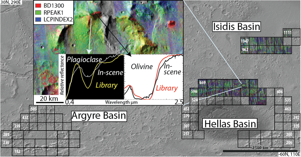
Fig. 1 Context view of the study area. Squares outline 5°x5° CRISM tiles. Number of tiles is 100, covering an approximate 5% of the surface. CRISM coverage is >80 % over tiled areas. Inset shows a region at the map scale of 1:250,000 with CRISM spectra of uplifted massifs compared to library spectra. In the spectral parameter combination, red is consistent with olivine, yellow with plagioclase, and blue with low-calcium pyroxene.
Methods.
CRISM Data Processing. We used CRISM multispectral mapping data (MSP) and hyperspectral mapping data (HSP). The MSP mapping strips have 19 visible to near-infrared (VNIR, 0.4-1 µm) spectral channels and 55 short-wavelength infrared (SWIR, 1-4 µm) channels, and the HSP mapping strips contain 107 VNIR channels and 154 SWIR channels. Both mapping datasets have a ground sampling distance of approximately 180 m. The set of wavelength channels contained in the MSP dataset were chosen to sample more densely in wavelengths regions known to contain absorption features of minerals likely to be detected on Mars (primary rock-forming silicates, phyllosilicates, etc. [3]). For our study, HSP data were resampled to the MSP wavetable to increase the spatial coverage. Typical coverage of the MSP+HSP dataset is ~85%, with sufficient overlap to allow for mosaicking and radiometric reconciliation. We processed these data through a custom pipeline [4] that includes initial noise filtering, photometric and atmospheric corrections [5], [6], and an empirical correction for “spectral smile” [7]. The final products of this pipeline are 5°x5° mosaic tiles with improved inter-strip variability in atmospheric residuals [8].
A typical method for condensing the information contained in a CRISM image into an interpretable form is by calculating “spectral parameters”, i.e., mathematical summations of particular characteristics of the spectra [9]. Spectral parameters can be combined into 3-band RGB images that highlight specific, thematically-related, combinations of interest. Fore example, the MAF summary product combines indexes intended to highlight mafic mineralogy: olivine (OLINDEX3), low-calcium pyroxene (LCPINDEX2), and high-calcium pyroxene (HCPINDEX2). From the CRISM mapping tiles, we constructed summary products that are well-suited for compositional mapping over large areas [10] (e.g., Fig. 1).
Compositional Mapping. Regions of interest were identified with the map tile summary products in ArcGIS followed up by detailed spectral analyses in IDL/ENVI (specialized software for analyzing hyperspectral images) with custom add-on analysis tools. Point locations of compositions, confirmed through spectral analysis, were imported back into ArcGIS and “outcrops” were mapped using summary products. We define outcrop in the context of this work as a spatially contiguous region with an internally consistent spectral signature distinct from its surroundings (e.g., Fig. 2).
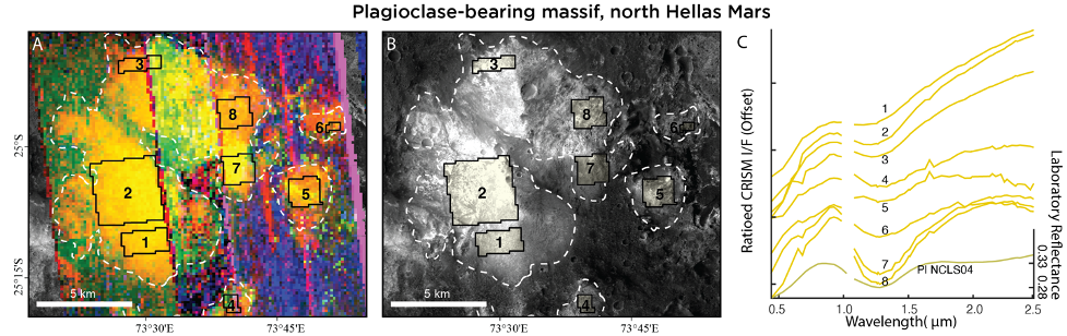
Fig. 2 Example plagioclase-bearing massif north of Hellas basin. (A) CRISM browse product (same as in Fig. 1). Yellow tones are consistent with plagioclase. Black boxes indicate 8 regions over which spectra were taken and plotted in C. (B) CTX 5 m/pixel image of the same massif as in (A). White dashed lines denote outcrops mapped in this A and B. (C) Average CRISM ratioed I/F spectra from the 8 regions indicated in A and B.
Results and Discussion.
Thus far, we have mapped 12 high-calcium pyroxene-bearing outcrops, 97 plagioclase-bearing outcrops, 128 LCP-bearing outcrops, and 129 olivine-bearing outcrops (Fig. 3). Outcrops with distinct mineralogical signatures are often observed adjacent to each other on the same massif, or on massifs in close spatial proximity (relative to the size of the massifs, ~several kilometers). We also identified Fe-, Mg-, and Al-phyllosilicate minerals associated with the massifs and, more commonly, with impact crater ejecta along the northern Hellas rim.
The number and spatial extent of plagioclase-bearing outcrops was surprising and is described in [11]. The massifs pre-date Hellas (≥ 4.1 Ga) and are situated stratigraphically above putative mantle material. The north Hellas massif outcrops may expose the remains of an ancient large igneous complex, perhaps similar to terrestrial layered mafic intrusions. Preliminary results from the Argyre and Isidis uplifted massifs will be presented at the conference and compared to those from north Hellas.
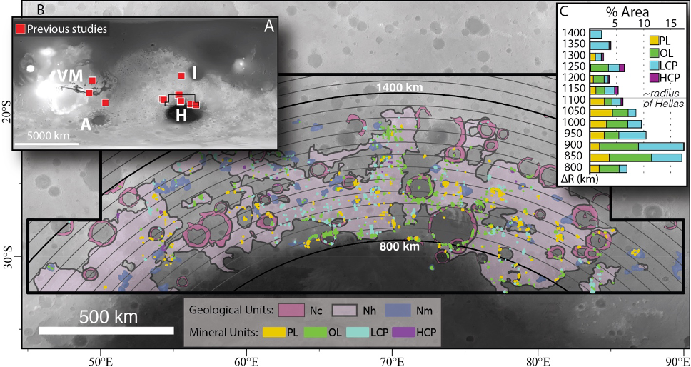
Fig. 3 Summary of detections over north Hellas. (A) Red squares indicate all locations of plagioclase-rich outcrops discovered previous to our work. (B) Context map showing all mafic mineral outcrops mapped in our study. Arcs are 50-km interval bins measured radially from the center of Hellas. Geologic units are Noachian crater (Nc), Noachian highland (Nh) and Noachian massif (Nm) from Leonard and Tanaka, 2001. (C) %Area is the area of each mineral outcrop normalized to the area of the Nc, Nh, and Nm geologic units in each radial bin. Note the concentration of detections interior to the nominal radius of Hellas, highlighting the stratigraphically low position of the outcrops.
[1] J. J. Bellucci et al. doi: 10.1016/j.epsl.2019.01.010.
[3] G. J. Leonard and K. L. Tanaka, 2001.
[4] S. L. Murchie et al. doi: 10.1029/2009je003344.
[5] F. P. Seelos and S. L. Murchie, LPSC. p. 2325, 2018.
[6] F. P. Seelos, et al., LPSC. p. 1783, 2016.
[7] F. Morgan et al., LPSC. p. 2453, 2011.
[8] F. P. Seelos et al., LPSC. p. 1438, 2011.
[9] F. P. Seelos, et al., LPSC p. 2635, 2019.
[10] C. E. Viviano‐Beck et al. doi: 10.1002/2014JE004627.
[11] C. E. Viviano et al., LPSC, p. 1485, 2020.
[12] Phillips, M. S., et al., Geology, accepted.
How to cite: Phillips, M., Viviano, C., Moersch, J., Rogers, A. D., and Seelos, F.: Mars uplifted massifs: unique and extensive samples of ancient crust. , Europlanet Science Congress 2022, Granada, Spain, 18–23 Sep 2022, EPSC2022-736, https://doi.org/10.5194/epsc2022-736, 2022.