
Multi-frequency Radar Characterization of Ganymede's Near-surface
 1,
1,- 1Institute for Geophysics, University of Texas at Austin, Austin, Texas, United States of America
- 2National Aeronautics and Space Administration (NASA) Ames Research Center, Moffett Field, California, United States of America
Introduction. Ganymede, Jupiter’s largest moon, is thought to have a salty subsurface ocean underlying an ice shell and may harbor the conditions to support life. The uppermost crust is mainly comprised of two types of terrain: heavily cratered, dark terrains and bright terrains often characterized by grooves [1]. The surface has also been subject to various landform degradation processes, such as mass movement, volatile segregation and migration, impact erosion, and regolith generation [2]. For example, such processes could be responsible for the formation of the dark deposits (layers) observed on Galileo Regio that vary in thickness (and other properties) as a function of their resting slope and position relative to local topographic crests, among other criteria [2]. Landform degradation processes thus can spatially alter the near-surface structure, characterized by different densities, impurities, and thicknesses (from tens to hundreds of meters). We present a radiometric approach for investigating the properties of near-surface layering at Ganymede from the combined observations of radar sounding systems that will reach the Jovian system within the next decade.
Multi-frequency Radar Sounders. The JUpiter ICy moons Explorer (JUICE) from the European Space Agency (ESA) will be orbiting Ganymede by 2034. Its science payload includes the Radar for Icy Moons Exploration (RIME), a 9-MHz central frequency radar sounder with a 1-MHz (low resolution) or 3-MHz (high resolution) bandwidth (noted [9/1 MHz] and [9/3 MHz], respectively) [3]. Nearly concurrently, the Europa Clipper from the National Aeronautics and Space Administration (NASA), will perform flybys of Ganymede once to thrice, providing complementary observations from the Radar for Europa Assessment and Sounding: Ocean to Near-surface (REASON), a dual frequency radar sounder at [60/10 MHz] and [9/1 MHz] [4]. This wealth of multi-frequency and multi-bandwidth observations is uniquely suited to constraining Ganymede’s near-surface properties through differential surface reflectometry.
Reflectometry of Layered Near-surfaces. Reflectometry is related to the measurement of the radar surface echo strength that is sensitive to surface and near-surface properties with a footprint-size spatial resolution of several kilometers (depending on the spacecraft altitude) [5]. The near-surface depth is bounded by the vertical resolution defined from the bandwidth of the transmitted signal. In void, [60/10 MHz], [9/1 MHz] and [9/3 MHz] radar systems have a vertical resolution of 15 m, 50 m and 150 m, respectively [4]. The reflection strength of a homogeneous icy near-surface combined with a smooth surface is nearly independent of the radar system across the RIME-REASON frequency range. However, a sharp dielectric gradient from a horizontal discontinuity in the near-surface affects the effective surface reflection coefficient (Re) because of the phase shift between the surface and the near-surface reflections that are coherently integrated when measured at the receiver. Thin-film theory provides analytical tools to predict Re for layered media as a function of the layers’ thickness and permittivity, as well as the signal wavelength [6].
As an illustration, consider an overburden layer of unknown thickness (zlayer) and permittivity (εlayer), bounded by a void (ε0 = 1), and covering a compact ice substrate (εice = 3.1). Fig. 1 illustrates the field of solutions for Re computed for the three radar systems considered and assuming a synthetic chirp of 100 μs. Each plot on Fig. 1 is characterized by two regimes. When zlayer is larger than the near-surface depth, then the signal strength is independent of zlayer across all frequencies and only dependent on εlayer. Note in particular that as zlayer gets thinner than the near-surface depth, Re exhibits a resonant behavior strongly dependent on zlayer relative to the radio wavelength. Hence, multi-frequency observations can be overlapped, although the solutions are not necessarily unique. However, additional constraints like assumed lateral continuity of the near-surface structure can help resolve most ambiguities.
In addition, surface roughness has a wavelength-dependent effect on surface reflectivity that can be difficult to deconvolve from the effect of near-surface layering. In that regard, because the [9/1 MHz] and [9/3 MHz] radar systems provide the same response to roughness (same radio wavelength), their response should differ only when layer boundaries are between their respective near-surface depths (different bandwidth).
A strategy based on the combination of the reflectivity plots in Fig. 1 for the range of frequencies/bandwidths deployed on Ganymede can then be used to constrain its near-surface properties. An analog application on a terrestrial ice cap is provided in the next section.
Proof-of-concept: Devon Ice Cap, Canadian Arctic. The near-surface of Devon Ice Cap (DIC) is subject to melting and refreezing processes, forming meters-thick ice layers embedded in lower porosity firn. The reflections from these layers from the surface down to the near-surface depth affect the coherent power (Pc) observed by a radar sounder (IPR). Fig. 2 illustrates a transect over DIC, where concurrent ground-penetrating radar (GPR) collected at 500 MHz and airborne IPR observations collected at [60/15 MHz] exist. Superimposed on the GPR radargram is a pink line that represents the frequency/bandwidth-constrained near-surface depth/vertical resolution of the airborne IPR. Results indicate that the behavior of Pc (green line) well correlates with the ice layer thickness within the near-surface depth and decorrelates below the near-surface depth at this frequency.
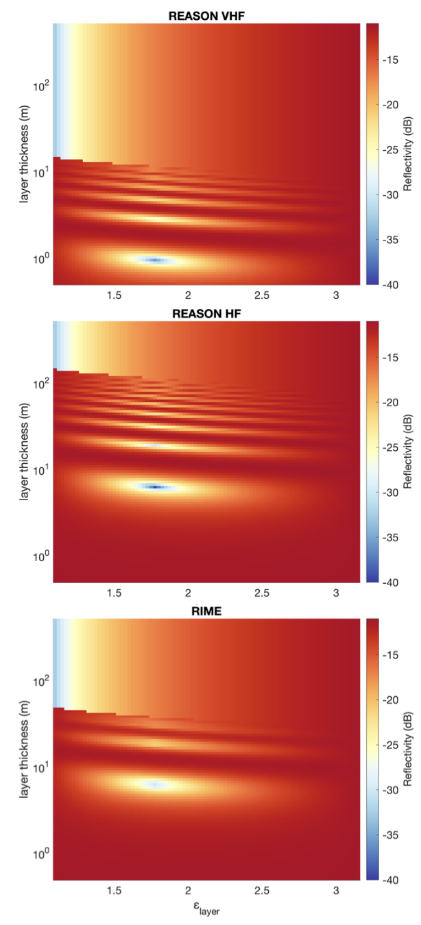
Figure 1: Coherent surface echo strength (Re) as a function of an overburden thickness (zlayer) and permittivity (εlayer) covering an icy substrate (εice = 3.1) for REASON VHF [60/10 MHz], REASON HF [9/1 MHz], and RIME [9/3 MHz].
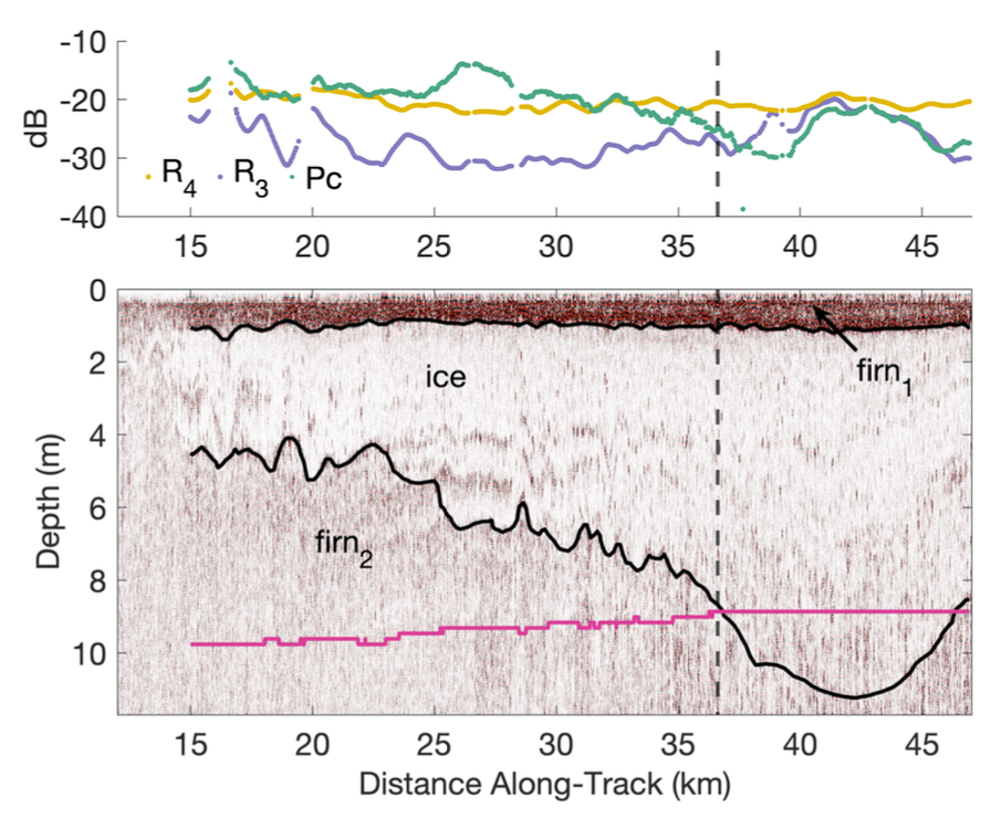
Figure 2: Observed coherent power and modeled reflectivity values (top), with concurrent GPR radargram (bottom) along a transect on Devon Ice Cap.
References: [1] R. T. Pappalardo et al., Jupiter: The Planet, Satellites and Magnetosphere (2004), pp. 363– 396. [2] J. M. Moore et al., Icarus 140.2 (1999), pp. 294– 312. [3] L. Bruzzone et al., Proceedings of the IEEE 99.5 (2011), pp. 837–857. [4] C. Grima et al., Planetary and Space Science 117 (2015), pp. 421–428. [5] C. Grima et al., Planetary and Space Science 103 (2014), pp. 191– 204. [6] P. Yeh. Hoboken, New Jersey: John Wiley & Sons, Inc., 1998.
How to cite: Chan, K., Grima, C., Moore, J. M., and Blankenship, D. D.: Multi-frequency Radar Characterization of Ganymede's Near-surface, Europlanet Science Congress 2022, Granada, Spain, 18–23 Sep 2022, EPSC2022-743, https://doi.org/10.5194/epsc2022-743, 2022.