VERITAS Radar Observations at Venus
- 1Jet Propulsion Laboratory, California Institute of Technology
- 2Smithsonian National Air and Space Museum
- 3Sapienza Universita di Roma
- 4German Aerospace Center (DLR)
- 5Stanford University
VERITAS is a NASA Discovery mission that was selected on June 2, 2021 and is a partnership between scientists and engineers at NASA/JPL and with the German (DLR), Italian (ASI) and French Space Agencies (CNES). VERITAS would carry two instruments, VISAR, an X-band interferometric radar provided by NASA/JPL with contributions from ASI and DLR, and VEM, an infrared spectrometer provided by DLR. Data from these two instruments would be combined with gravity science data obtained from telecom tracking data to investigate tectonic style and ongoing volcanism. Science data is collected in two phases after arriving at Venus after a 7-month cruise from Earth. During the second phase of science data collections VERITAS plans to collect radar data for image generation, topographic mapping and targeted repeat pass radar interferometry observations to measure surface deformation .
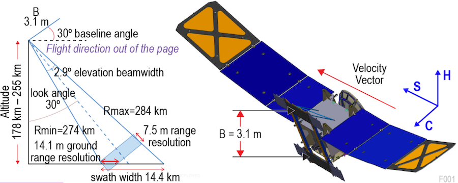
VERITAS has two phases of science operation. The first science phase (SP1) for VEM operations occurs during a 4-month interruption in the middle of 16 month aerobraking phase, which is needed to achieve the desired circular orbit needed for Science Phase 2 observations of both the VISAR and VEM instruments. The final nearly circular polar orbit used for SP2 varies between 180 and 255 km in altitude. SP2 lasts for 4 Venus sidereal days or ‘cycles’, each of which is 243 days in duration owing to the very slow rotation rate of Venus. The orbit is designed as a frozen eccentricity orbit so that its trajectory nearly repeats from cycle to cycle to facilitate repeat pass radar observations.
VISAR nominally collects data for 11 orbits on both ascending and descending passes followed by 5 orbits of data downlink to Earth. Data is processed onboard to multi-looked imagery and interferograms to reduce the data downlink volume up to 1000 fold. The exception to this is when repeat pass radar interferometry (RPI) data is collected for targeted sites on the surface. Since RPI sites are 200 km (along-track) × 200 km (cross-track) in extent, raw data for 20 consecutive orbits (Venus rotates 10 km at the equator during a VERITAS orbit) are needed to map a site. Raw data are downlinked for processing on Earth. Downlinked data volume as well as ∆V and other operational considerations limit the number of RPI sites to approximately12-18.
Fig. 1: VISAR flight configuration and observing geometry are optimized for InSAR DEM acquisition with baseline separation B = 3.1 m.
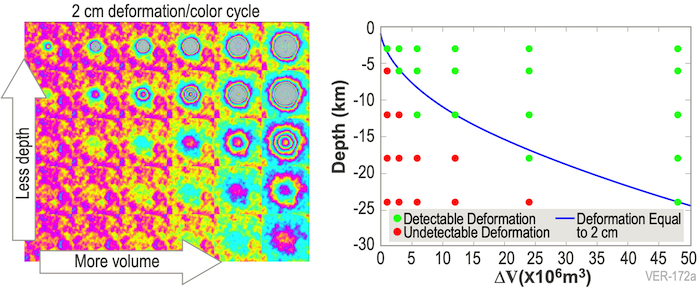
Venus is expected to be active today. VERITAS requires detection of 2-cm deformations for spatial scales of 1 km (e.g., fault creep) and 2 cm at 40 m horizontal postings for small-scale (e.g., volcanic) features. To access which deformation signals would be discernible given the expected amount of atmospheric noise we simulated volcanic deformation using various localized, spherical sources (a.k.a. Mogi sources) for a range of source depth and delta volumes. We assumed Earth-like magma chambers at depths of 2-28 km and delta volumes of 1-48 km3, in reasonable agreement with the few Venusian volcanoes for which these parameters can be estimated. Figure 2 shows that inflation above magma chambers at a range of depths, even including atmospheric variability, produces a readily discernible deformation exceeding 2 cm, assuming 1.5 cm of atmospheric distortion at 200 km length scale.
Fig. 2: Deformations above 2 cm are detectable with VISAR RPI techniques, after accounting for observed S02 variability. Left: Fringe patterns (2 cm of deformation per color cycle) for 30 Mogi point sources with atmospheric distortion superimposed. Right: De formation above or near the detectability limit are shown as green dots; those obscured by atmospheric distortion are red.
Radar image, topographic and RPI data along with data from the VEM instrument and gravity measurements to answer three essential science questions: 1) What processes shape rocky planet evolution? 2) What geologic processes are currently active? and 3) Is there evidence of past and present interior water? VERITAS’ VISAR instruments is integral to endind many 30-year-old debates for Venus, such as whether volcanism has been steady or catastrophic, why it lacks terrestrial-style plate tectonics, how it loses its heat, and if it has continents.
A portion of this research was conducted at the Jet Propulsion Laboratory, California Institute of Technology, under contract with the National Aeronautics and Space Administration.
How to cite: Hensley, S., Smrekar, S., Campbell, B., Mastrogiuseppe, M., Perkovic-Martin, D., Younis, M., and Zebker, H.: VERITAS Radar Observations at Venus, Europlanet Science Congress 2022, Granada, Spain, 18–23 Sep 2022, EPSC2022-751, https://doi.org/10.5194/epsc2022-751, 2022.


