Geostructural mapping of the Michelangelo (H-12) quadrangle of Mercury: relationship between tectonic and crustal structures
- 1Dipartimento di Scienze della Terra, dell'Ambiente e delle Risorse, Università degli Studi di Napoli "Federico II", Naples, Italy (salvatore.buoninfante@unina.it)
- 2Istituto di Astrofisica e Planetologia Spaziali (IAPS), INAF, Rome, Italy
- 3Dipartimento di Scienze e Tecnologie, Università degli Studi di Napoli "Parthenope", Naples, Italy
Introduction: The Michelangelo quadrangle of Mercury (H-12) encompasses the area between latitudes 22.5°S-65°S and longitudes 180°E-270°E. The first geological map of the H-12 quadrangle was produced by [1] at 1:5M scale using Mariner 10 data. They have identified and mapped five classes of craters and four main plain units: intecrater, intermediate, smooth and very smooth plains. Here, we present a new geological study of this quadrangle, derived from the photointerpretation of the MErcury Surface, Space ENvironment, GEochemistry, and Ranging (MESSENGER) Mercury Dual Imaging System (MDIS) imagery. This geological investigation will contribute to the 1:3M geological map series campaign that constitutes a basic work to identify targets proposed for science observations during the ESA-JAXA BepiColombo mission [2]. Furthermore, our purpose is to map the tectonic structures at the southern boundary of the High-Mg region, in order to verify any possible linkage between fault systems and the areal distribution of this geochemical terrain, as observed in other quadrangles [3]. Three main contractional structures have been recognized on Mercury: wrinkle ridges, lobate scarps and high-relief ridges. A global map of the tectonic structures of Mercury was provided by [4]. With our work we will provide an updated structural framework of the area and study the relationship of the mapped structures with crustal discontinuities also with the help of geophysical analysis of the gravimetric data.
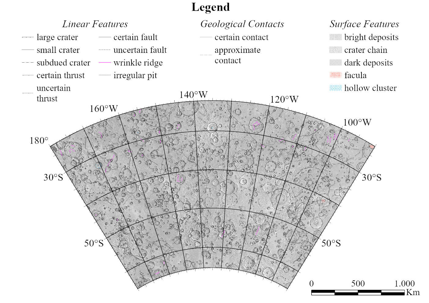
Geological Mapping: We are currently mapping the tectonic structures and geological units using the MDIS derived basemaps, with an average resolution of 166 m/pixel. In particular, we use the map-projected Basemap reduced Data Record (BDR), the map-projected Low-incidence Angle (LOI) basemap, the map-projected High-Incidence angle basemap from the East (HIE) and the map-projected High-Incidence angle basemap from the West (HIW). In addition, we use the USGS global Digital Elevation Model (DEM) to better distinguish morphological features, and the color and enhanced color basemaps to distinguish surface features (faculae, hollows, dark deposits, bright deposits, crater chains). Linear features are subdivided into large craters (crater rim diameter > 20 km), small craters (5 km < crater rim diameter < 20 km), subdued or buried craters, certain or uncertain thrusts, certain or uncertain faults, wrinkle ridges and irregular pits (Fig. 1), consistently with other mapped quadrangles [2].
Structural Analysis: We have identified two main thrusts systems with NW-SE and NE-SW trends. Comparing the mapped fault systems with the X-Ray Spectrometer (XRS) Mg/Si abundance, the NW-SE system appears to be broadly coinciding with the south-western edge of the High-Mg region, although we are aware that the accuracy of XRS data at this latitudes is much lower than those acquired in the northern hemisphere. We identified tectonic structures that are arranged radially with respect to large basins (e.g., Beethoven). Indeed, as also shown by [5], some older basins, such as Beethoven (20.8°S-236.1°E) and Vincente-Yakovlev (52.6°S-197.9°E), are responsible for a reactivation of their edges with the formation of lobate scarps. We mapped some vents that are located along lobate scarps or at soft-linkage transition zone between different scarp segments, which, on the Earth, are considered as possible preferential areas for magma uprise.
Future Work: We plan to complete the 1:3M geological mapping of the Michelangelo quadrangle including characterization of the plains units. Moreover, we will perform a geophysical analysis of the gravity anomalies, to identify the main crustal structures and to investigate how Mercury’s tectonic structures relate to large crustal discontinuities.
Acknowledgements: This work is part of the PhD project of SB at the University of Naples Federico II. We gratefully acknowledge funding from the Italian Space Agency (ASI) under ASI-INAF agreement 2017-47-H.0.

Figure 1. Preliminary geostructural map of the Michelangelo Quadrangle. Basemap is the MDIS BDR 166m mosaic.
References:
[1] Spudis P. D. and Prosser J. G., (1984). U.S. Geological Survey, IMAP 1659.
[2] Galluzzi et al. (2021). LPI Contrib. No. 2610.
[3] Galluzzi et al. (2019). J. Geophys. Res. 124(10), 2543-2562.
[4] Byrne P. K., (2014). Nature Geosci., 7(4), 301-307.
[5] Fegan E. R. et al., (2017). Icarus, 288, 226-234.
How to cite: Buoninfante, S., Galluzzi, V., Ferranti, L., Milano, M., and Palumbo, P.: Geostructural mapping of the Michelangelo (H-12) quadrangle of Mercury: relationship between tectonic and crustal structures , Europlanet Science Congress 2022, Granada, Spain, 18–23 Sep 2022, EPSC2022-811, https://doi.org/10.5194/epsc2022-811, 2022.

