Evolution of fluvial, and possible lacustrine or marine activity in Nilosyrtis, Mars - A geomorphological & chronostratigraphic analysis.
- 1University of Gothenburg, Earth sciences, Sweden (emelie.saar@gmail.com)
- 2University of Pisa, Pisa, Earth Sciences, Italy.
Introduction
Today, Mars’ surface is defined as a cold hyper-arid desert, but geomorphological and geochemical observations have shown that in the past, vast amounts of liquid water were stable at the planet’s surface (Di Achille et al. 2006, Erkeling et al. 2012, Hauber et al. 2009). With the increased coverage of high-resolution remote sensing datasets, investigations of possible remnants of fluvial processes in the Martian landscape have significantly increased during the last couple of decades. The spatiotemporal evolution of hydrological events is however not well understood (Erkeling et al. 2012). In this master thesis study, an impact crater in the region of Nilosyrtis Mensae has been mapped to identify geomorphological evidence that can increase the understanding of the spatiotemporal evolution of landforms at the dichotomy boundary on Mars.
Method & Data
The mapping was made using ArcGIS Pro version 3.1.0. with inspiration taken from the FGDC Digital Cartographic Standard for Geologic Map Symbolization (USGS, 2006) as well as the Italian cartographic standard Geomorphological Map of Italy at 1:50,000 scale by ISPRA (2021). The Context Camera [CTX] mosaic & raw images (5-6 m/px) and High Resolution Imaging Science Experiment [HiRISE] images (0.3-0.25m/px) as well as the THEMIS IR mosaic dataset of 100m/px were used to map surface features. 3D models were used in this study to support interpretations, such as the HRSC DEM product mosaic of 50m/px. By using the MarsSI application (marssi.univ-lyon1.fr) overlapping CTX raw images have been processed for HiRISE & CTX imagery to create DEM products with 12 m/px and 0.5 m/px respectively.
Geological setting
The study crater is 80+ km wide and is located at the dichotomy boundary. The crater lacks primary impact morphology and ejecta. The northeastern wall is completely degraded and opens up towards the northern plains. Moreover, the crater wall is incised by several channels of which two channels connects to adjacent craters of similar size, located east and west of the study area. The crater floor forms a palimpsest landscape of different landforms suggesting a very complex history of sedimentation, exhumation and erosion.
Result
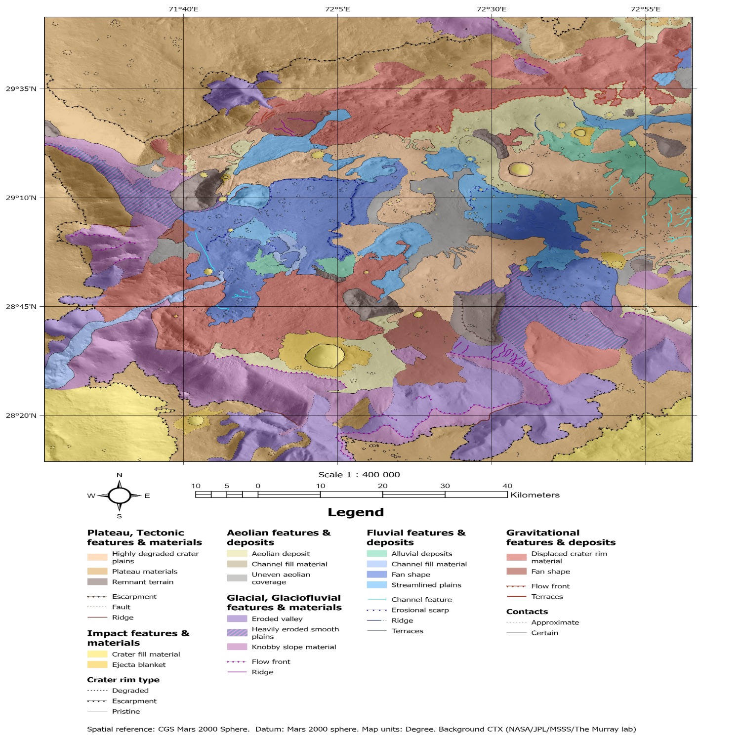
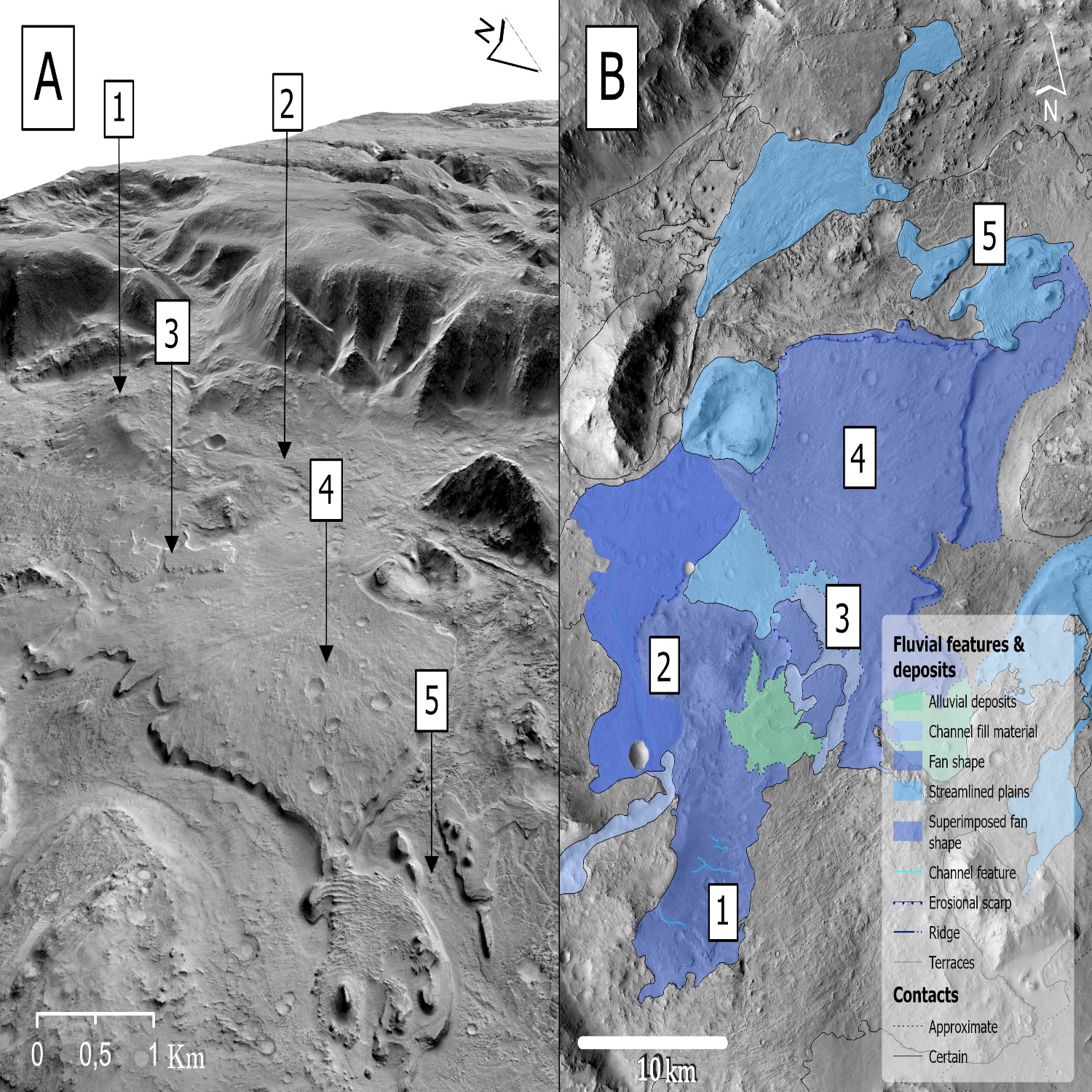
The main result is the geomorphological map produced by this study (Fig.1). Key findings include a set of fan-shaped landforms that partially cover the crater floor. Some fans are associated with valley incisions and one of the larger fans is heavily affected by impact cratering. The fan shapes have a variety in surface texture, morphology, size and stratigraphic positions. Multiple elongated fan shapes combined with streamlined plains, alluvial deposits have been identified at the termination of the southwestern valley inlets (Fig. 2).

Figure 1. A geomorphological map of an impact crater basin in Nilosyrtis Mensae, Mars, at approximate
29°N, 72°E draped over the CTX satellite mosaic (NASA/JPL/MSSS/The Murray lab
Spatial reference: CGS Mars 2000 Sphere. Datum: Mars 2000 sphere. Map units: Degree.

Figure 2. A) 3D view of the valley inlet entering the study crater from the southeast. B) An overview of the mapped units of possible fluvial genesis in the western region of the impact crater basin. Fan shape 1 and 2 are deposited in a close spatial proximity to the channel inlet, while fan shape unit 3 is found further out, divided by a depression of possible alluvial deposition. Fan shape unit 4 covers a large part of the crater floor and does exhibit unique geomorphological features at the top of the streamlined plains marked at 5. Image credit: NASA/JPL/MSSS/The Murray lab.
Discussion & Conclusion
The diverse classification of landforms and interpreted geneses shows that the studied crater has experienced a long history of degradation, deposition by various processes and erosion since its formation. The superposition between geological units suggests a scenario where fluvial deposition have occurred episodically. Bamberg et. al., (2014) describes the geological history of the floor-fractured crater which is connected to the studied crater by a channel inlet from the northwest. The possible fluvial landforms in the studied crater suggests a close relationship to the hypothesized scenario by Bamberg et al., (2014) of a major fluvial event. Lesser fluvial activity followed, predominantly controlled by conditions in the study crater. In conclusion, the geomorphology suggests a long and complex history of fluvial events. An impact of possible lacustrine or marine conditions could not be confirmed nor refuted. The framework of the thesis did not allow for more detailed studies using spectral data. Work that includes CRISM may provide further insights into the temporal evolution in the studied crater.
References
Bamberg et.al., (2014). Floor-Fractured Craters on Mars – Observations and Origin. Planetary and Space Science, 98, 146–162. https://doi.org/10.1016/j.pss.2013.09.017
Di Achille et.al., (2006) Geological evolution of the Tyras Vallis paleolacustrine system, Mars. Journal of Geophysical Research, 111(E4), E04003-N/a.
Erkeling, et.al., (2012). Valleys, paleolakes and possible shorelines at the Libya Montes/Isidis boundary; implications for the hydrologic evolution of Mars. Icarus 219(1), 393-413.
Hargitai, (2019). Planetary Cartography and GIS. Springer.
Hauber, et.al., (2009). Sedimentary deposits in Xanthe Terra: Implications for the ancient climate on Mars. Planetary and Space Science, 57(8), 944-957
ISPRA. (2021). Geomorphological Map of Italy at 1:50,000 scale - Update and additions to the Guidelines of the Geomorphological Map of Italy at 1:50,000 scale and Geomorphological Database (Version 2.0). Volume 13, issue 1 Volume 13, Part I - The CARG Project: changes and additions to the Quaderno n. 4/19944/2022. https://www.isprambiente.gov.it/resolveuid/45c17b95e93f45cda3e1c2fa0f5e06fa
USGS. (2006). FGDC Digital Cartographic Standard for Geologic Map Symbolization (PostScript Implementation. U.S. Geological Survey Techniques and Methods 11-A2. Derived 2023-12-29 from:https://pubs.usgs.gov/tm/2006/11A02/
How to cite: Saar, E., Sassenroth, C., and Johnsson, A.: Evolution of fluvial, and possible lacustrine or marine activity in Nilosyrtis, Mars - A geomorphological & chronostratigraphic analysis., Europlanet Science Congress 2024, Berlin, Germany, 8–13 Sep 2024, EPSC2024-1077, https://doi.org/10.5194/epsc2024-1077, 2024.