The Planet Explorer: Navigating Planetary Sample Data in Spatial Dimensions
- 1Museum für Naturkunde, Leibniz-Institut für Evolutions- und Biodiversitätsforschung, Berlin, Germany
- 2Freie Universität Berlin, Institute of Geological Sciences - TRR 170, Berlin, Germany
- 3Archium, Gera
Introduction: Renewed interest in a human return to the Moon has revived the importance of past Apollo missions. Both manned and robotic missions to the Moon provided detailed information on locations of instruments, and locations of returned lunar samples. The upcoming lunar missions will produce a large amount of new data, including on samples returned from the Moon. Integration of such data with spatial data can aid in comprehending and analyzing the complexities of lunar data. Here we present a test version of the lunar version of the web-based browser Planet Explorer, which combines seamlessly lunar surface imageries with lunar landing site data without the need of handling file format details and data ingestion by the user.
Data Visualization: Planet Explorer is a web browser based on the open software packages OpenLayers [1] and three.js [2] for combining planetary data sets and visualizing results. We have developed and implemented a test version that uses high-resolution images obtained with the Lunar Reconnaissance Orbiter Camera [LROC, 3] that are available in the open access LROC data archive [4]. The LROC narrow-angle camera [NAC, 3] has extensively imaged a substantial portion of the Moon's surface, achieving a resolution of 1 meter per pixel or better.
Of particular interest are images that are matched with high-resolution digital elevation maps derived from stereo image pairs [5]. This LROC dataset includes all previous landing sites and many other locations of interest such as the Luna and Chang’e lunar landing sites. In Planet Explorer, the lunar maps can be supplemented with additional data sets from any location. Currently available data in Planet Explorer are • Layer and layer categories: geology, labels, structure (Fig. 1) • Epoch features: surface features of selected lunar epochs (pre-Nectarian to Copernican (Fig. 2a, b), color-coded areas indicate, for instance, geological units • Display of global and local lunar geological maps [6] • Location overlays with geological nomenclature and structural features • Analysis and map data from the TRR170-DB repository [7] of the DFG research program TRR 170 ‘Late Accretion onto Terrestrial Planets’ (Fig. 4.) • Other internet-based resources: i.e., lunar sample compendium [8].
Fig. 1: Menu view of Planet Explorer test case showing the nearside of the Moon's surface [9].
Integration of External Data: Currently implemented test cases allow for combining LROC images matched with high-resolution digital elevation maps with sample data and other information. Sample data or other information can be linked or displayed on imageries from the LROC archives [4].
Lunar sample data currently used by the Planet Explorer is retrieved from open access resources, e.g., the lunar sample compendium [8], and data from the curated and open access TRR170-DB repository of the TRR 170 research program ‘Late Accretion onto Terrestrial Planets’ [7], and from other internet-based resources.
Fig. 2a: Geological map of the lunar farside (pre-Nectarian to Copernican) [10].
Fig. 2b: Geological map of the lunar nearside [11].
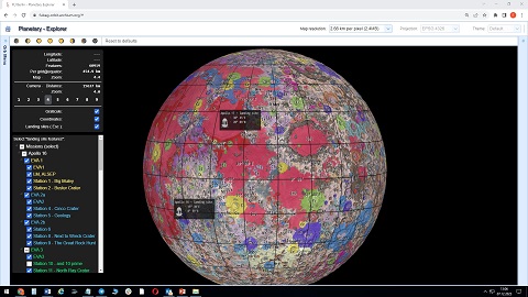
The current test version of the Planet Explorer offers selected, curated sample data and related information from the Apollo 16 and 17 landing sites. These landing sites are represented as markers on the interface (Fig. 3). Users have the option to select specific locations, such as stations at these landing sites allowing the browser to present comprehensive data summaries for the selected locations.

Fig 3. displays various layer categories and surface features of different epochs. Markers indicate Apollo 16 and 17 landing sites as examples
After choosing a point of interest (e.g., a landing site), the tool exhibits detailed historical and current information conveniently accessible through the left menu. This information informs on i.e., tracks, stations, instrumentation, and sample locations pertinent to that mission. Additionally, the visual representation of mission tracks and station locations is overlaid with integrated information on specific products such as i.e., sample analyses or comprehensive chemical or mineralogical maps (Fig. 4).
Fig 4. Tracks and stations of the Apollo 16 landing site. The table associated with station EVA01 displays sources of related overview data [8, 12].
Future Dataset Integration: Planet Explorer offers a digital framework that serves as a valuable resource for displaying compositional characteristics and various properties (such as geology, gravity, etc.) of the surface or near-surface of the Moon and other planetary bodies. Additionally, it is an effective tool for visualizing research data in a spatial data context. For forthcoming Lunar missions, the Planet Explorer may aid in the study of potential landing sites for future lunar exploration. We plan the release of an open access version of Planet Explorer in 2024.
Acknowledgements: Funded by Deutsche Forschungsgemeinschaft DFG (Grant SFB-TRR 170, #263649064-INF).
References (as retrieved on May 13, 2024):
[1] OpenLayers, openlayers.org
[2] three.js, https://threejs.org/
[3] LRO Camera, https://www.lroc.asu.edu/about
[4] LROC archive, https://www.lroc.asu.edu/archive
[5] http://wms.lroc.asu.edu/lroc/search
[6] Fortezzo et al. (2020), Release of the digital unified global geological map of the Moon at 1:5,000,000-scale, abstract #2760, LPSC
[7] TRR170-DB Repository, (https://info.planetary-data-portal.org/)
[8] Lunar Sample Compendium, https://curator.jsc.nasa.gov/lunar/lsc/
[9] Spatial Reference, https://spatialreference.org/ref/iau2000/30101/
[10] Geological map of the lunar farside, https:// www.hou.usra.edu/meetings/lpsc2020/pdf/2760.pdf
[11] Geological map of the lunar nearside, https:// www.hou.usra.edu/meetings/lpsc2020/pdf/2760.pdf
[12] Haase et al., https://doi.org/10.1029/2018EA000408
How to cite: Lehmann, E., Balduin, A., Seidel, M., Wendel, K., and Becker, H.: The Planet Explorer: Navigating Planetary Sample Data in Spatial Dimensions, Europlanet Science Congress 2024, Berlin, Germany, 8–13 Sep 2024, EPSC2024-1163, https://doi.org/10.5194/epsc2024-1163, 2024.