
Map of major landforms in Shackleton Crater, lunar South Pole
- 1Land and Water CA, Berlin, Germany (a_mitusov@mail.ru)
- 2Institute of Basic Biological Problems, RAS, Pushchino, Russia
- 3Institute of Geodesy and Geoinformation Science, Technische Universität Berlin, Berlin, Germany
Introduction and the map
Since the overview of Shackleton Crater by Zuber et al. (2012), geomorphologic structures on its floor have not been seriously considered. It was due to problems of visual observations in permanent darkness, and the limited number of morphometric variables used for the altimetry data analysis. Based on solution of these problems we built the objective borders of major landforms in Shackleton Crater (Fig. 1) and reconstructed their formation histories.
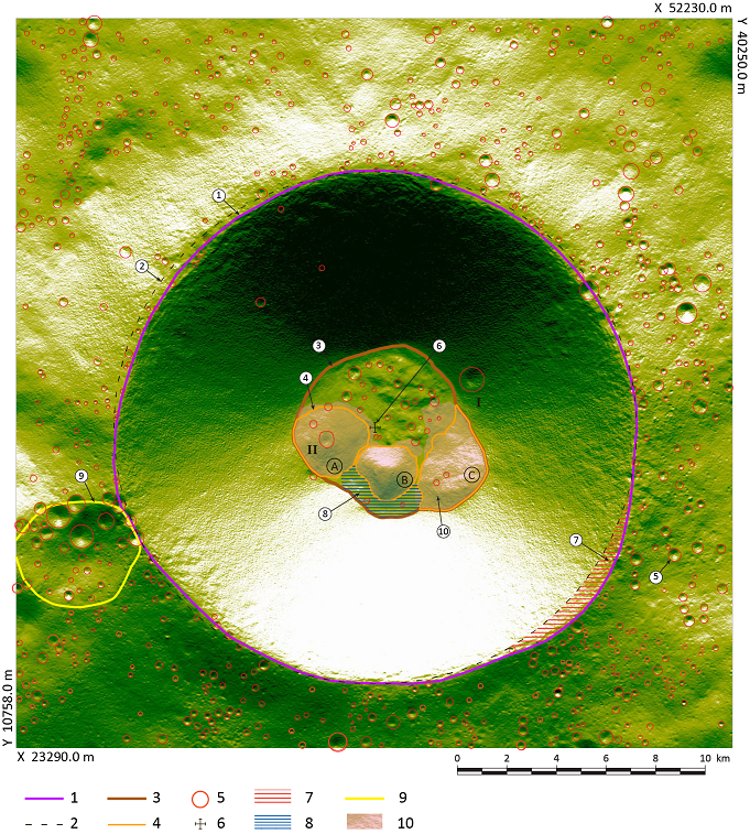
Figure 1. Map of major landforms in Shackleton Crater. “A”, “B” and “C” – main elevated structures on the crater floor. 1 – real top of Shackleton Crater rim. 2 – ideal circle approximated the top of Shackleton Crater rim. 3 – border of Shackleton Crater floor. 4 – border of the elevated structures “A”, “B” and “C”. 5 – clearly visible small impact craters with the size between 0.01 and 1.2 km2. 6 – geometric centre of Shackleton Crater: this centre was used for the polygons 1 and 2. 7 – area of possible landslide source above the elevated structure “C”. 8 – relatively flat field between the elevated structure “B” and the slope of Shackleton Crater. 9 – largest crater (in this article: “Shackleton-A”) located on exterior slope of Shackleton Crater rim above the structure “A”. 10 – area of the tree-like pattern detected by the map of kh on and around the elevated structures “A”, “B” and “C”. 11 – area of Shackleton’s foot slope deposits characterised by the linear pattern on the map of kh. I – remnants of the largest impact crater on the interior wall of Shackleton Crater. II – impact crater on the top of the elevated structure “A”. The background map shows artificial insolation. The lateral grid spacing is 20 m.
Methods
A Digital Elevation Model (DEM) with 20 m grid was constructed based on Lunar Orbiter Laser Altimeter (LOLA) data. To accurate description of the topography we performed a co-registration of the profiles (Stark et al. 2017). A video (Fig. 2) of the artificial insolation of this DEM from different angles is available at the YouTube channel "Land and Water CA" (Mitusov et al., 2022).
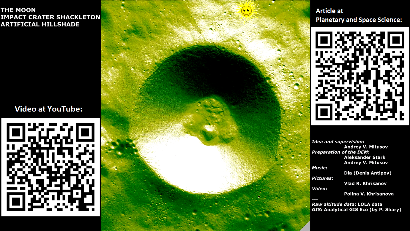
Figure 2. Video screenshot of the artificial insolation of the DEM from different angles at the YouTube channel "Land and Water CA" (Mitusov et al., 2022: https://www.youtube.com/watch?v=gAY0JYlOkK4).
The DEM was analysed for slope steepness, Maximal Catchment Area (MCA) and four curvatures: maximal (kmax), minimal (kmin), horizontal (kh) and vertical (kv). All Morphometric Variables (MVs) were calculated using Analytical GIS Eco (e.g. Shary et al., 2002).
The high sensitivity of MVs helps spatial localization of pixels with altitude anomalies. Based on this, we easily identified natural hidden structures and errors in the DEM.
Elevated structures “A”, “C” and “B”
Elevated structures "A" and "C" are clearly identified as landslides, confirming the opinion of Zuber et al., (2012). For both structures the material sources are visible at the top of Shackleton Crater rim as deviations of the real rim (Fig. 1, contour 1) from the ideal circle (Fig. 1, contour 2). The source area for landslide “C” (Fig. 1, polygon 7) is larger, and equals 5.9 km2. The most probable trigger of these landslides is the large meteorite impact visible as Shackleton-A Crater (Fig. 1, polygon 9).
The exposed initial floor of Shackleton and Shackleton-A are characterised by the comparable number of younger small craters. This confirms the formation of Shackleton-A, and landslides in the form of elevated structures “A” and “C”, relatively soon after the formation of Shackleton Crater itself.
The origin of elevated structure “B” is not related to any sedimentary process. We suggest two hypotheses of this structure formation: a central peak, or a small volcanic dome without central pit.
Slope erosion and sedimentation
The almost linear parallel stripes with kh > 0 in the foot slope zone (Fig. 1, polygon 11) are identified as granular debris flow terminations.
The shape and the slope inclination of elevated structures "A", "B" and "C" caused the lateral distribution of granular flows. This process formed the tree-like structures (Fig. 3). The rare occurrence of small craters (Fig. 1, index 5) confirms the tree-like pattern was formed due to long-term erosion, transition and accumulation.
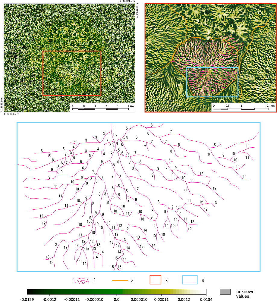
Figure 3. Identification of tree-like structures on the map of kh: the example of the elevated structure “B”. 1 – Indication of tree-like structures by the generalised lines above upper parts of flow divergence zones (kh > 0). 2 – Borders of the elevated structures A, B and C. 3 – Enlarged area. 4 – Example of the hierarchical levels numbering. Each segment from the upper branch to the lower branch (in several cases – convergence) was counted. The smallest order is at the summit of the elevated structure B.
Conclusion and extension
We suggest an in-situ exploration of water traces in the foot slope deposits marked by polygon 11 (Fig. 1). The thickest slope deposits up to 120 m (Fig. 1, polygon 8) are also promising target, however this area is topographically isolated.
The complete research is: Mitusov, A. V., Stark, A., Khrisanov, V. R., Oberst, J. (2023). Hidden morphology of Shackleton Crater, lunar South Pole. Planetary and Space Science, 238, 105795. https://doi.org/10.1016/j.pss.2023.105795
Donations
This research involved a large amount of unpaid time! We will be grateful for any BTC donations to our team: bc1qa33qmar5y97xskh5hfms7lckq7cfel4vtyu7qa
References
- Mitusov, A. V., Stark, A., Khrisanov, V. R., Khrisanova, P. V., Antipov (Dia) D. (2022). Crater Shackleton at the lunar South Pole. YouTube channel "Land and Water CA". https://www.youtube.com/watch?v=gAY0JYlOkK4
- Shary, P. A., Sharaya, L. S., Mitusov, A. V. (2002). Fundamental quantitative methods of land surface analysis. Geoderma, 107(1-2), 1-32.
- Stark, A, Oberst, J, Scholten, F, Gläser, P. (2017). Measurements of Moon's Rotation by Co-Registration of Laser Altimeter Profiles and Stereo Terrain Models. 48th Lunar and Planetary Science Conference, The Woodlands, Texas. https://www.hou.usra.edu/meetings/lpsc2017/eposter/2304.pdf
- Zuber, M. T., Head, J. W., Smith, D. E., Neumann, G. A., Mazarico, E., Torrence, M. H., Aharonson, O., Tye, A. R., Fassett, C. I., Rosenburg, M. A., Melosh, H. J. (2012). Constraints on the volatile distribution within Shackleton crater at the lunar South Pole. Nature, 486(7403), 378-381.
How to cite: Mitusov, A. V., Khrisanov, V. R., and Oberst, J.: Map of major landforms in Shackleton Crater, lunar South Pole, Europlanet Science Congress 2024, Berlin, Germany, 8–13 Sep 2024, EPSC2024-144, https://doi.org/10.5194/epsc2024-144, 2024.