
MAPPS: Multi-Mission Science Operations Planning Evolution and Adaptation
- 1Aurora Technology for European Space Agency (contact author, carlos.muniz.solaz@ext.esa.int)
- 2European Space Astronomy Centre (ESAC - ESA)
- 3Starion Group for European Space Agency
- 4Telespazio for European Space Agency
- *A full list of authors appears at the end of the abstract
The Mission Analysis and Payload Planning System (MAPPS) has evolved over the past two decades to meet the complex and dynamic planning requirements of various ESA planetary missions [1][2]. Originally designed solely for visualizing Mars Express experiment coverage on Mars, MAPPS now offers science planning capabilities for several missions, including Mars Express, ExoMars TGO (Trace Gas Orbiter), BepiColombo, Solar Orbiter, Juice (JUpiter ICy moons Explorer), and EnVision.
These missions present diverse and sometimes conflicting planning needs, such as contrasting power, data volume, or thermal requirements. For instance, Juice requires considerations for long-distance communication and thermal stability in cold outer regions, while BepiColombo prioritizes managing thermal loads and power generation due to its proximity to the Sun.
The primary tool available to the Science Operations Centres (SOC) in ESAC during the science planning process is MAPPS, that has been adapted to these complexities by becoming highly configurable and continuously updating to meet the unique demands of each mission. It operates by consolidating observation requests from the instrument teams, merging them into a comprehensive plan, and extensively simulating and modeling instruments to detect conflicts or constraint violations. The validated plan results in the generation of a multi-instrument operations timeline for uplink to the spacecraft's Mission Operations Centre (MOC).
Recently, MAPPS has included support for multi-body and constellation coordination, crucial for missions like Juice, which orbits Jupiter and its moons for extended periods. Adapting MAPPS for such missions required significant modifications to accommodate observations initially designed for a single central body. Additionally, MAPPS has facilitated collaboration with other Mars missions [3], enabling tasks like radio-science experiments between MEX-TGO [4], communication tests between ESA and NASA orbiters, or regular data relays in support of all surface assets.
Furthermore, MAPPS has been extensively used during the operations studies that were finalized with the adoption of EnVision, by providing essential information about instrument coverage, pointing, or resources consumption.
In summary, MAPPS plays a crucial role in ensuring efficient and conflict-free science planning processes by managing inputs, performing simulations, verifying constraints, generating output files, and executing supporting tasks. Here, we would like to present the main new features and capabilities that make this tool so powerful for science operations and mission analysis.
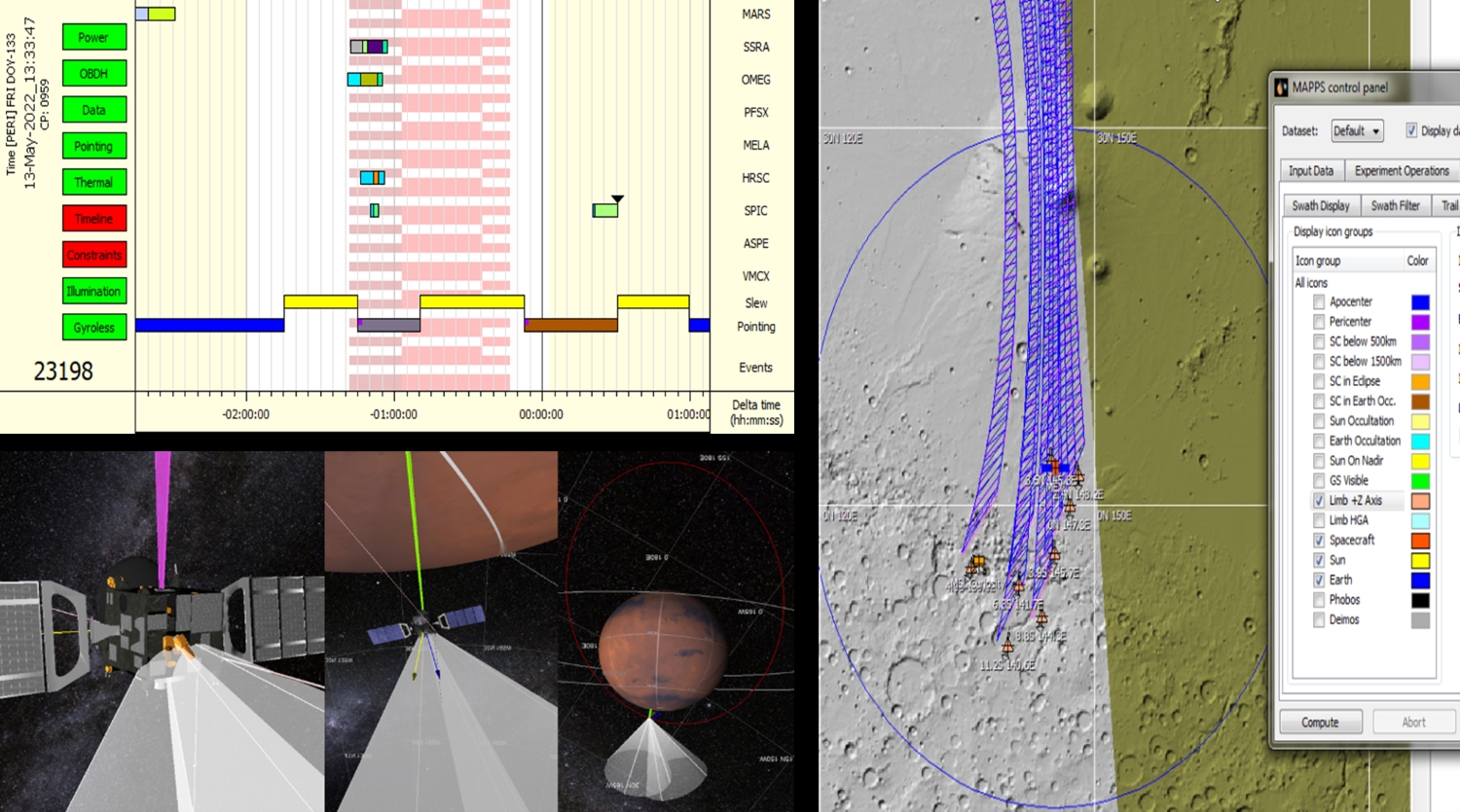
a) A snapshot of the graphical timeline for one of the Mars Express orbits. It conveys information about the instrument’s modes and actions, along with spacecraft pointing and downlink periods. b) In addition to the graphical timeline, it is possible to validate the planning using 3D visualizations. c) The swaths of the instruments, spacecraft trails, or landmarks can be configured and projected onto 2D maps.
REFERENCES
[1] P. van der Plas et al., MAPPS: a science planning tool supporting the ESA solar system missions, SpaceOps 2016 Conference, AIAA 2016-2512, https://doi.org/10. 2514/6.2016-2512
[2] Cardesin-Moinelo, A., Godfrey, J., Grotheer, E., Blake, R., Damiani, S., Wood, S., Dressler, T., Bruno, M., Johnstone, A., & Muniz, C. (2024). Mars Express: 20 Years of Mission, Science Operations and Data Archiving. Space Science Reviews, 220(2), DOI:10.1007/s11214-024-01059-0
[3] Cardesín-Moinelo et al., First year of coordinated science observations by Mars Express and ExoMars 2016 Trace Gas Orbiter, ICARUS 2021, https://doi.org/10.1016/j.icarus.2020.113707
[4] Cardesín-Moinelo et al. Coordination of Mars Express and Trace Gas Orbiter joint observations of the Martian atmosphere in 2021-2022. EPSC September 2022 Granada
MEX SGS Team, Bepi Colombo SGS Team, TGO SGS Team, Juice SGS Team, Solar Orbiter SGS Team, EnVision SGS Team
How to cite: Muniz, C., Cardesin-Moinelo, A., Frew, D., de la Fuente, S., Felix, F., Ibarmia, S., Martin, P., Nespoli, F., Mahieux, A., Ashman, M., Lefort, J., and Valles, R. and the ESA Planetary Science Operations Centres: MAPPS: Multi-Mission Science Operations Planning Evolution and Adaptation, Europlanet Science Congress 2024, Berlin, Germany, 8–13 Sep 2024, EPSC2024-252, https://doi.org/10.5194/epsc2024-252, 2024.