Investigation of geomorphic features in the Makgadikgadi Basin (Botswana) using Ground Penetrating Radar: implications for the formation of Martial surface landforms
- 1Addis Ababa University, P.O.Box:1176, Addis Ababa, Ethiopia
- 2Department of Mineral Resources, School of Earth Sciences and Engineering, Botswana International University of Science and Technology, Palapye, Botswana
- 3Dipartimento di Scienze della Terra e Geoambientali, Università degli Studi di Bari - Aldo Moro, Bari, Italy
The Makgadikgadi pans (playa lakes) in Botswana form the largest salt pan system in the world. The formation of these pans is related to a tectonic activity possibly linked to the East African Rift System, which caused the subsidence and infilling of a large endoreic basin. Changes in climate and tectonics eventually led to the drying up of the ancient lake, leaving behind the salt pans we see today. The basin consists of two major pans, namely Sua and Ntwetwe pans.
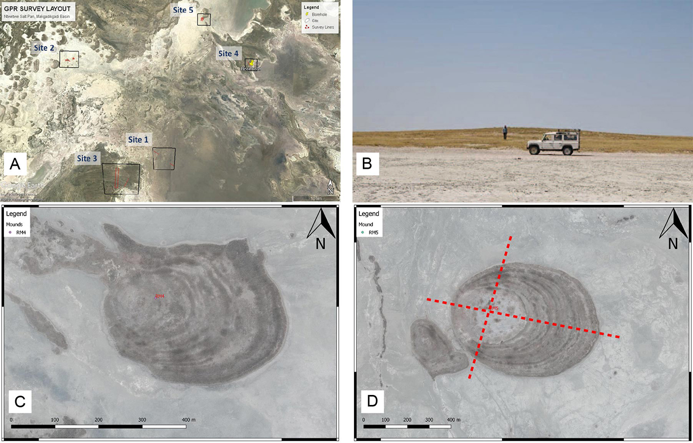
These pans are mostly flat, at an elevation of ca. 908 m a.s.l., but feature distinct geomorphic elements such as mounds and paleo- delta and shorelines that can be easily identified through satellite imagery (Franchi et al., 2020). In the western part of the Ntwetwe pan, there are numerous mounds, several hundreds of meters wide and with an average height of 5m (Figure 1). These mounds are primarily composed of fine-grained sands, calcite nodules and ostracods shells (Franchi et al., 2022). While several theories have been proposed for their origin, the internal sedimentary structure of these geomorphic features remains unknown.
On Mars, conical mounds are significant morphological features that have been observed and mapped in various regions. The Noachian-Hesperian climate change on Mars resulted in the deposition of crudely layered sediments in the equatorial region, where fluctuations in groundwater played a crucial role. These layered sediments, known as Equatorial Layered Deposits (ELDs), contain numerous mounds that were exposed due to impact craters (Pondrelli et al., 2015).
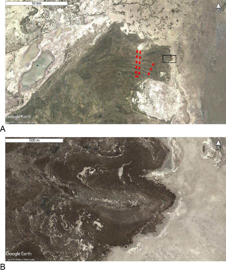
A relict fan delta was identified by previous studies in the southern Ntwetwe Pan (Figure 2). The delta is linked to the paleo-Boteti river, one of the main seasonal rivers that fed the basin before desiccation and shows a system of inverted channels and polygonal fractures (Figure 2) and was considered as a suitable analogue of the paleo-drainage systems on Mars.
The objective of this study is to investigate the mounds and the relict fan delta in the Ntwetwe pan using geophysical methods, particularly Ground Penetrating Radar (GPR). By employing GPR, we aim to image the internal structure of these mounds and other geomorphic features, with the ultimate goal of understanding the formation and preservation of similar structures on the Martian surface.
Several sites within the Ntwetwe pan were selected for GPR survey, primarily along east-west and north-south profiles (Figure 1). The survey was done using Mala ProEx acquisition system. The system uses rough terrain antennae with an in-line configuration for 30 and 50MHz frequencies. Over a period of six days, approximately 23 kilometers of GPR data were collected. Most of the surveys utilized 50MHz antennas, while three lines were acquired using both 50MHz and 30MHz antennas to attain penetration depth as well as resolution. Preliminary results indicate clear imaging of the top 15 meters over the mounds and delta sites. In addition, 2D profiles were acquired over structures previously mapped using aeromagnetic and Electrical Resistivity Tomography (ERT) methods (Schmidt et al., 2023).
Here we focus mostly on the results coming from the mounds in the western part of the study area and on a delta found close to center of the basin. Five (5) lines were acquired over mound structures RM-4 and RM-5 (Figure 1). These mounds were previously studied using cores drilled to the bottom of the mounds (Franchi et al., 2022) and geological log from this study were used to correlate reflections with geological contacts. Two lines were acquired over RM-5 and three lines were acquired over RM-4 with a general E-W and N-S trend. Three (3) lines were acquired over the relict fan delta (Figure 2). The survey was designed to cross distributary channels at high angles over the delta plain. A total of four lines were acquired over the delta with three lines trending N-S in different parts of the delta and one E-W line connecting cross lines (Figure 2).
The preliminary processing steps applied to data include correction applied to setup geometry, recover gain and suppress noise and adjust static shifts. The result from the survey has shown that the GPR data was effective in mapping up to a depth of ~15m in the study area. The imaging result shows better quality over the studied geomorphic features allowing to describe the internal stratigraphy of the mounds and the role of groundwater in their formation. This has important repercussions on the discussion of groundwater upwelling forming layered deposits and mounds in the equatorial region of Mars.
REFERENCES:
Franchi, F., MacKay, R., Selepeng, A.T., Barbieri, R., 2020. Layered mound, inverted channels and polygonal fractures from the Makgadikgadi Pan (Botswana): possible analogues for Martian aqueous morphologies. Planetary and Space Science 192, 105048. Doi: 10.1016/j.pss.2020.105048
Franchi F., Cavalazzi B., Evans M., Filippidou S., Mackay R., Malaspina P., Mosekiemang G., Price Alex, Rossi Veronica, 2022. Late Pleistocene–Holocene Palaeoenvironmental Evolution of the Makgadikgadi Basin, Central Kalahari, Botswana: New Evidence From Shallow Sediments and Ostracod Fauna. Frontiers in Ecology and Evolution 10, doi: 10.3389/fevo.2022.818417
Pondrelli, M., Rossi, A.P., Le Deit, L., Fueten, F., van Gasselt, S., Glamoclija, M., Cavalazzi, B., Hauber, E., Franchi, F.,Pozzobon, R., 2015. Equatorial Layered Deposits in Arabia Terra, Mars: facies and process variability. GSA Bulletin 127 (7-8), 1064-1089. Doi: 10.1130/B31225.1
Schmidt, G., Luzzi, E., Franchi, F., Selepeng, A.T., Hlabano, K., Salvini, F., 2023. Structural influences on groundwater circulation in the Makgadikgadi salt pans of Botswana? Implications for martian playa environments. Front. Astron. Space Sci. 10:1108386. doi: 10.3389/fspas.2023.1108386
FIGURE CAPTIONS:

Figure 1. A) Location of all the GPR line completed during the survey, sites are numbered 1 to 5. Here we focus on sites 2 (the mounds) and 3 (the relict fan delta). B) Field view of the mounds in the Ntwetwe pan (from Franchi et al., 2020). C-D) Satellite view of mound RM4 and RM5 (from Franchi et al., 2020). Red lines in D show the approx. direction of the GPR lines.

Figure 2. A) The fan delta in the southern Ntwetwte Pan, showing in red the GPR lines. B) Polygonal structures on the delta. Modified from Franchi et al., 2020.
How to cite: Shawel, M., Selepeng, A. T., Kgosidintsi, B., and Franchi, F.: Investigation of geomorphic features in the Makgadikgadi Basin (Botswana) using Ground Penetrating Radar: implications for the formation of Martial surface landforms, Europlanet Science Congress 2024, Berlin, Germany, 8–13 Sep 2024, EPSC2024-406, https://doi.org/10.5194/epsc2024-406, 2024.