TP3 | Planetary field analogues for Space Research

TP3

Planetary field analogues for Space Research
Conveners: Fulvio Franchi, Barbara Cavalazzi | Co-conveners: Gareth Davies, Alexandra Hillebrand-Voiculescu, Jonathan Merrison, Roger Lawrence R. L. Gibson, Felipe Gómez
Orals
| Tue, 10 Sep, 14:30–16:00 (CEST)|Room Uranus (Hörsaal C)
Posters
| Attendance Tue, 10 Sep, 10:30–12:00 (CEST) | Display Tue, 10 Sep, 08:30–19:00|Poster area Level 2 – Galerie
Orals |
Tue, 14:30
Tue, 10:30
Planetary field analogues (PFAs) are places on Earth sharing physical, chemical, or geological and environmental similarities with extra-terrestrial environments or approximate conditions or features found on other planetary bodies. PFAs are essential for ongoing and coming missions, including testing and improving technologies, workflows and protocols, space mission concepts, and human factors for space exploration.
In this session we welcome abstracts on different surface planetary processes, geochemical and astrobiological investigations using field analogues and laboratory simulation studies, field methods and sampling techniques. We also encourage abstracts focused on studies testing robotic missions and research regarding training crewed exploration missions and strategies, and testing exploration technology applications. Furthermore, we welcome abstracts outlining the use of the analogue field sites in engaging the public, as well as space agencies, the media, and educators.

Session assets

Discussion on Discord

Orals: Tue, 10 Sep | Room Uranus (Hörsaal C)

Chairpersons: Fulvio Franchi, Barbara Cavalazzi, Felipe Gómez
Mars analogues
14:30–14:40
|
EPSC2024-175
|
On-site presentation
Enrico Bruschini, Marco Ferrari, Cristina Mazzoni, Stefano Fazi, Agnese Piacentini, Giovanna Costanzo, Simone De Angelis, Jeremy Brossier, Maria Cristina De Sanctis, and Francesca Altieri

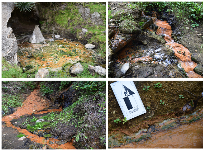
It is widely accepted that Mars, in its early history, underwent different stages of aqueous alteration with waters characterized by variable pH and chemistry (e.g., Bibring et al. 2006, Hurowitz and McLennan 2007). While it is commonly assumed that neutral-to-alkaline aqueous weathering produces clays while more acidic waters lead to the formation of sulfates (e.g., Bibring et al. 2006) it is not always easy to fit the recent observations of the rovers deployed on Mars with this simple two-stage model. In this regard, the mineralogical, chemical, and microbiological investigation of Earth analog sites is of paramount importance to advance our understanding of planetary surfaces evolution. Here we discuss the combined mineralogical and microbiological investigation of a terrestrial site located in central Italy (SW margin of the Alban Hills volcanic complex) and characterized by extensive CO2 and H2S cold discharges. H2S oxidation resulted in sulfur mineralization between 26 and 47 Ky (Voltaggio et al. 2001). The area was interested by sulfur extraction between 40 and 50 years ago which deeply modified the morphology and water circulation of the site with the formation of shallow ponds. The presence of sulfur and its oxidation products combined with the presence of water bodies results in extremely low pH (1-3) of the ponds (Fig. 1).

Figure 1. The Stagno Bianco (White pond) is characterized by active sedimentation of sulfur and an extremely low pH (1.18).

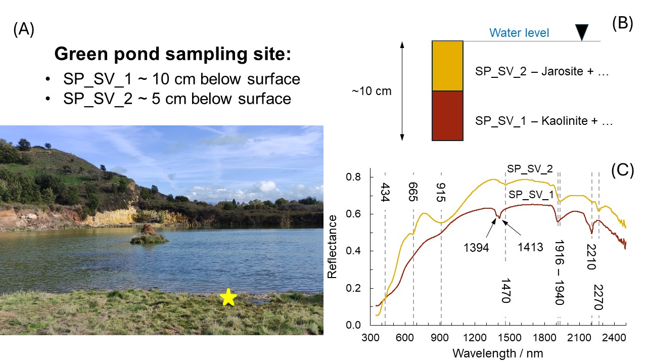
We collected samples along the shores of the ponds as well as from weathered rocks outcropping in the area. The collected samples were analyzed by a combination of VNIR reflectance and Raman spectroscopy to characterize the mineralogical components. The organic materials were detected and visualized using fluorescence microscopy, to quantify and describe the microbial community we instead extracted and sequenced the DNA. Our results highlight the diffuse presence of sulfates (jarosite) and dioctahedral clay (kaolinite) in correspondence with the ponds characterized by pH between 2.8 and 3 (Fig. 2), whereas in the most acidic pond (White pond) we detect the presence of sulfur likely mixed with minor amounts of amorphous materials. Kaolinite is also present throughout the site as the result of weathering of the volcanic rocks. We identified soils particularly enriched in oxides/hydroxides in the uppermost layers of the site.

Figure 2. Green pond sampling site. Panel (A): the yellow star marks the sample collection site. Panel (B) shows the stratigraphy of the collected materials. Panel (C) shows the spectra of the samples and the main absorptions (dashed lines and numbers corresponding to band position): the deeper sample (SP_SV_1 - 10 cm) is characterized by a dominance of kaolinite with likely presence of oxides while the upper layer (SP_SV_2 – 5 cm) is dominated by jarosite.

DNA analysis will characterize the microbial community present in such an extreme environment and will help to constrain the role of bacteria in the synthesis of secondary minerals (i.e., jarosite and kaolinite). Our work will have a direct impact on Martian exploration by refining our knowledge of acidic aqueous alteration of volcanic materials. In addition, it will contribute to the understanding of the interactions between microbes and minerals in acidic conditions which is of high relevance from an astrobiological point of view.

Fundings: the authors acknowledge the support from the Italian Space Agency (ASI) project N◦ 2023-3-HH.0 ″Attività scientifica di preparazione all’esplorazione marziana”. This work was also supported by MINI GRANTS 2023 RSN-3 INAF-Bando di Astrofisica Fondamentale 2023.


References:

  • Bibring, J. P., Langevin, Y., Mustard, J. F., Poulet, F., Arvidson, R., Gendrin, A., ... & Neukum, G. (2006). Global mineralogical and aqueous Mars history derived from OMEGA/Mars Express data. science, 312(5772), 400-404. https://doi.org/10.1126/science.1122659  
  • Hurowitz, J. A., & McLennan, S. M. (2007). A∼ 3.5 Ga record of water-limited, acidic weathering conditions on Mars. Earth and Planetary Science Letters, 260(3-4), 432-443. https://doi.org/10.1016/j.epsl.2007.05.043
  • Voltaggio, M., Di Lisa, G. A., & Voltaggio, S. (2001). U-series disequilibrium study on a gaseous discharge area (Solforata of Pomezia, Alban Hills, Italy): implications for volcanic and geochemical risk. Applied geochemistry, 16(1), 57-72. https://doi.org/10.1016/S0883-2927(00)00019-6

How to cite: Bruschini, E., Ferrari, M., Mazzoni, C., Fazi, S., Piacentini, A., Costanzo, G., De Angelis, S., Brossier, J., De Sanctis, M. C., and Altieri, F.: Mineralogical and microbiological characterization of the Solforata of Pomezia, Alban Hills, Italy. A case study from a possible Mars analog site., Europlanet Science Congress 2024, Berlin, Germany, 8–13 Sep 2024, EPSC2024-175, https://doi.org/10.5194/epsc2024-175, 2024.

14:40–14:50
|
EPSC2024-1039
|
ECP
|
On-site presentation
Anna Grau Galofre and Axel Noblet

Glacial erosion on Mars, and specifically the presence and role of basal meltwater on glacial processes, is a matter of long-standing debate. Whereas observations of glacial landforms related to warm-based glaciation exist both for early Mars (e.g., the Dorsa Argentea ridges) as well as for Amazonian Mars (esker ridges in Phlegra Montes), the inventory of glacial landforms seems to be largely limited to that of subglacial drainage. Here we present results from an analogue study comparing interlinked subglacial cavity systems located on the central-western portion of the Greenland Ice Sheet (GIS), specifically in the region around Kangerlussuaq, with potential subglacial interlinked cavities identified on Batson crater, located northeast of the Hellas basin on Mars. The GIS near Kangerlussuaq is known for subglacial drainage systems consisting on meltwater-filled cavities on a hard bed (Harper et al., 2017), which may become interconnected following episodes of increased discharge. Episodes of connectivity following high pressure subglacial meltwater events may lead to enhanced sliding followed by channelization, and emplacement of subglacial floods (Harper et al., 2017).

We present preliminary field and remote sensing observations describing the morphology, topology, organization, and other field characteristics of recently exposed elements of the glacial hydrology system in this analogue site, which were emplaced by the western margin of the GIS. Our field site is located by the Europlanet Transnational Access TA1 Facility 4: Greenland-Kangerlussaq, which offers a unique opportunity to study the subglacial drainage patterns in this region (Carrivick et al., 2016). Few regions in the world offer the opportunity to study recently emplaced, well exposed subglacial morphologies at the level of accessibility of this site. Field data includes in situ-imagery, observations of glacial sliding directions, description of sedimentary deposits, morphology, scale and characteristics of subglacial cavities, and nature of the connection passages. Data acquired in the field is complimented with remote sensing data from the ArcticDEM and Maxar imagery. We then discuss the morphology and geometry of observed interconnected subglacial cavities to morphologically and topologically similar systems located at the Batson crater site on Mars (Grau Galofre et al., 2024), and present a morphometric comparison as well as a qualitative description of similarities and differences with the terrestrial analogue site. We finally discuss the implications for the presence of subglacial interconnected drainage patterns on Mars, and the lessons learned from the Kangerlussuaq analogues to derive identification guidelines, which can assist the community in identifying this somewhat obscure subglacial landforms.

How to cite: Grau Galofre, A. and Noblet, A.: Field observations of Mars analogue subglacial drainage systems in Kangerlussuaq - Greenland ice sheet western margin., Europlanet Science Congress 2024, Berlin, Germany, 8–13 Sep 2024, EPSC2024-1039, https://doi.org/10.5194/epsc2024-1039, 2024.

14:50–15:00
|
EPSC2024-1091
|
ECP
|
On-site presentation
Işık Su Yazıcı, Thomas Kenkmann, Sebastian Sturm, Oguzcan Karagoz, Ernst Hauber, and Daniela Tirsch

 Summary

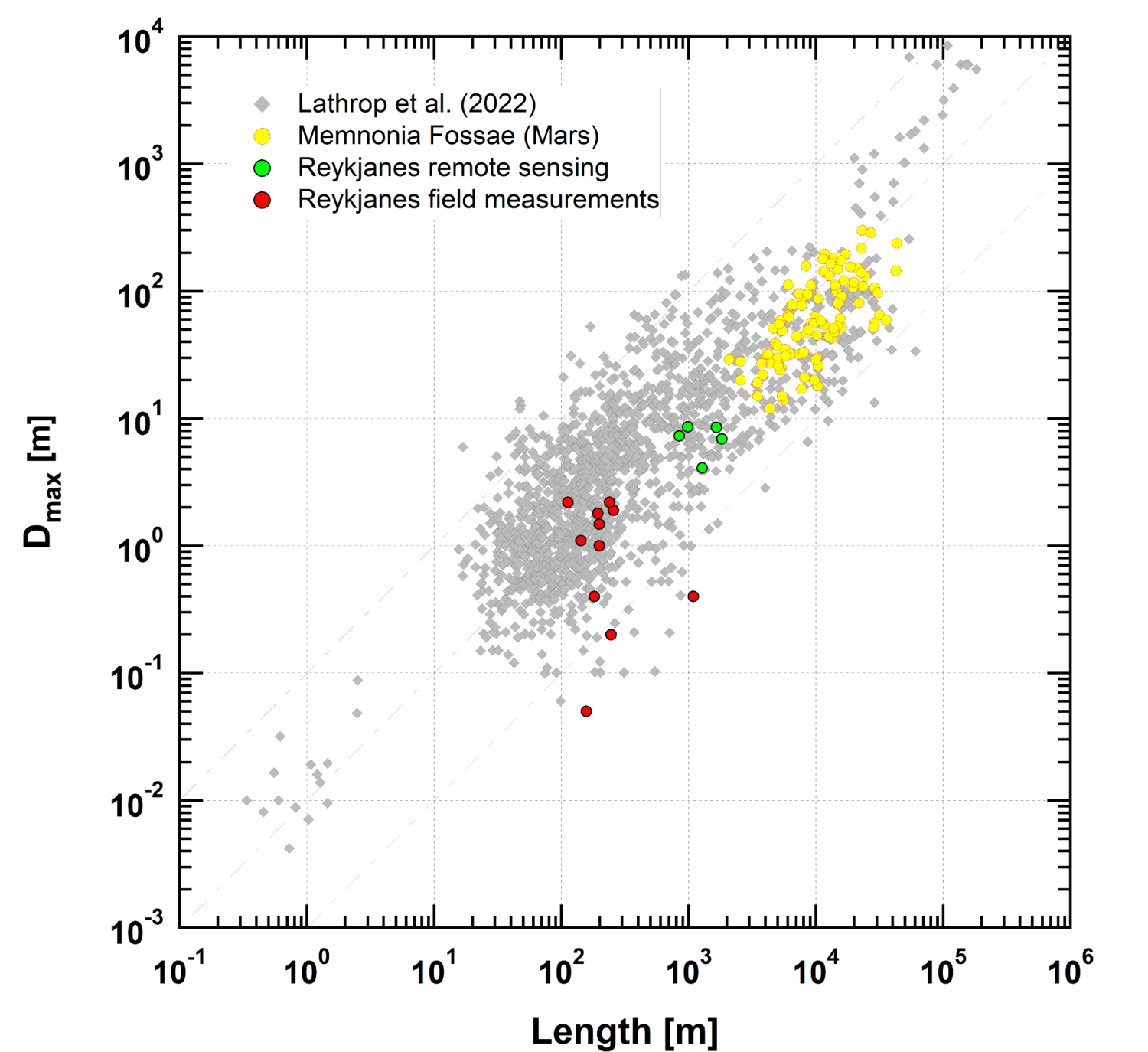
The understanding of geometric fault properties is crucial for reconstructing the geological evolution of a tectonic region. However, there is a notable lack of fault scaling studies on extraterrestrial bodies due to limited reliable topographic data, creating a gap in planetary structural geology research. To address this gap, focused research on fault scaling in extraterrestrial environments is necessary, with analogous investigations on Earth serving as essential supporting activities. A previous study in the Memnonia Fossae region on Mars examined normal faults, offering insights into their geometric characteristics and kinematics. The Memnonia Fossae, a series of narrow grabens extending from Mars' main volcanic region, Tharsis, was analyzed, with a Dmax/L ratio of 0.007 calculated based on measurements from 100 individual faults. To aid this study, normal faults in Iceland's Reykjanes peninsula were chosen as an Earth analogue due to similar lithologies and potential tectonic influences. Fieldwork in Iceland involved gathering measurements of 74 faults and fractures, recording parameters such as opening, shear sense, throw, and extension vectors. Preliminary results indicate a Dmax/L ratio of 0.005, with further comparisons planned between measurements from Mars, Earth, and beyond, to be discussed at an upcoming conference within the context of comparative structural geology.

 Introduction

Thorough examination of the geometric characteristics of faults offers valuable insights into how fault systems evolve mechanically and temporally [1, 2] as well as their potential for seismic energy release in the past and future [3]. In planetary science, where seismometers are scarce, examining faults through remote sensing data often provides the only direct observational evidence for understanding a planet's tectonic history [4]. Given the strong correlation between fault geometry and seismic moment release, studying populations of faults aids in estimating seismic activity levels [5,6]. Yet, there is a noticeable gap in fault scaling studies on planetary bodies due to the limited availability of reliable topographic data [7]. This underscores the need for more focused research on fault scaling beyond Earth. Conducting similar investigations on Earth is also vital to support quantitative analyses of fault geometries on other planets. Such comparative studies not only aid in interpreting remote sensing data more accurately, but also enhance our comprehension of planetary structures.

 Data and Methods

During the fieldwork, measurements of 74 faults and fractures at designated 180 waypoints in Reykjanes peninsula were obtained to characterize fault features in this region. Parameters such as strike, dip direction, dip angle, perpendicular opening, extension vector direction and length, shear component direction and length, vertical displacement length and direction of the faults were directly recorded in the field. Faults from different ages of lava flows, their spatial and temporal relationship as well as the structural geological evolution are also investigated.

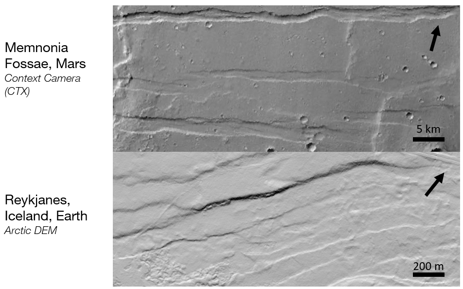
Field data, when combined with remote sensing information, significantly impacts the study, offering a broader perspective and information as well as a good correlation with the Mars faults. Hence, for larger faults, field measurements were supplemented with data obtained through remote sensing methods (Fig 1). All topographic remote sensing measurements in this study acquired from Digital Elevation Models (DEM) of the Arctic DEM project’s TanDEM-X mission [9]. Fault length was digitized along the fault line, and multiple topographic cross-sections across the fault were collected. In the gathered cross-sections, fault throw, serving as an approximation of actual displacement, was visually assessed. Dmax is determined from the subsequent crossing profiles, and Dmax/L ratio is calculated.

Figure 1: Images show normal faults in Memnonia Fossae, Mars and Reykjanes, Iceland. a. DEM derived from Context Camera (CTX), b. Arctic DEM of TanDEM-X mission.

 Results

Initial findings indicate a Dmax/L ratio of 0.005. Results are consistent (Figure 2) with the previously measured Memnonia Fossae, Mars Dmax/L ratio as well as previously calculated Earth Dmax/L on volcanic rocks [10]. Faults on Mars share the geometric characteristics of Earth analogue faults. We plan to juxtapose our results with previous fault measurements from Mars, Earth, and other planetary bodies at an upcoming conference, presenting additional calculations and discussing them within the framework of comparative structural geology. This field expedition involves more than just studying geological phenomena in Iceland; it also serves as a comprehensive examination of fault scaling dynamics. Its findings could have significant implications for enhancing remote sensing-based research on fault scaling across various planetary bodies.


Figure 2: Dmax/L ratio comparisons of Memnonia Fossae, Reykjanes, and volcanic rocks on Earth [10].

Acknowledgment

This work was supported by Europlanet Transnational Access Iceland funding.

References

[1] Cartwright, J. A., et al., (1995) J. Struct. Geol. 17, 1319-1326. [2] Cowie, P.A. and Scholz, C.H., (1992) J. Struct. Geol. 14, 1133-1148. [3] Wells, D.L. and Coppersmith, K.J. (1994) Bull. Seismol. Soc. Amer., 84, 974-1002. [4] Schultz, R.A. et al. (2010) J. Struct. Geol., 32, 855-875. [5] Golombek, M.P. et al. (1992) Science 258, 979-981. [6] Knapmeyer, M. et al. (2006) J. Geophys. Res., 111, E11006. [7] Gwinner, K. et al., (2010) Earth Planet. Sci. Lett. 294, 506-519. [8] Clifton, A. E., & Kattenhorn, S. A., (2006) Tectonophysics, 419(1-4), 27-40. [9] European Space Agency, Sinergise, Copernicus Global Digital Elevation Model (2021). [10] Lathrop, B. A., et al., (2022) Frontiers in Earth Science, 10, 907543.

How to cite: Yazıcı, I. S., Kenkmann, T., Sturm, S., Karagoz, O., Hauber, E., and Tirsch, D.: Fault scaling at the Reykjanes Peninsula (Iceland) as a Mars Analogue: Displacement-length relationship in comparison with Memnonia Fossae, Mars, Europlanet Science Congress 2024, Berlin, Germany, 8–13 Sep 2024, EPSC2024-1091, https://doi.org/10.5194/epsc2024-1091, 2024.

15:00–15:10
|
EPSC2024-969
|
ECP
|
On-site presentation
Paul Eckstein, Sabrina Carpy, Philippe Claudin, Jonathan Merrison, Jens Jacob Iversen, Laurent Perret, and Tanguy Bertrand

In the proposed oral presentation, we will report on the first results of our latest experimental campaign in the Aarhus Wind Tunnel Simulator II. The campaign took place in March 2024, with the goal of observing the evolution of the surface morphology of a slab of CO2 ice that is sublimating away, being exposed to different wind speeds and atmosphere configurations.

The phenomenon we were looking for are so-called “sublimation waves”. These are transverse ripples or scallops that emerge on icy substrates under the influence of wind-driven sublimation. The emergent wavelength, migration velocity and formation timescale of confirmed sublimation waves on the Blue Ice Areas in Antarctica [Weller, 1969; Mellor and Swithinbank, 1989; Bintanja et al, 2001], on walls of ice caves [Curl, 1966] and on the Martian North Polar Cap [Bordiec et al, 2020] can be linked through a set of scaling laws derived from a linear instability analysis [Claudin et al, 2017] of the turbulent boundary layer flow over a sublimating substrate [Bordiec et al, 2020; Carpy 2023].

If the scaling laws were validated systematically, remote observation of bedforms could be used to map the prevailing surface winds on planets with icy surfaces, without the need for in-situ measurements. This could provide new constraints for global circulation models over ice surfaces like on Pluto. Thus the presented experimental campaign in the AWTS-II investigated the sublimating behaviour of CO2 ice under varying flow viscosity and velocity, to compare with behaviour predicted by the sublimation wave scaling laws. Our experiment campaign follows up on earlier sublimation experiments on CO2 ice at the Aarhus Planetary Environment Facility. As previous attempts suffered from the heterogeneity of the substrate, being composed of blocks of dry ice (frozen CO2, made from compacted snow and thus opaque), this time we could form the CO2 ice slab through direct deposition of CO2 gas onto a cold plate. 

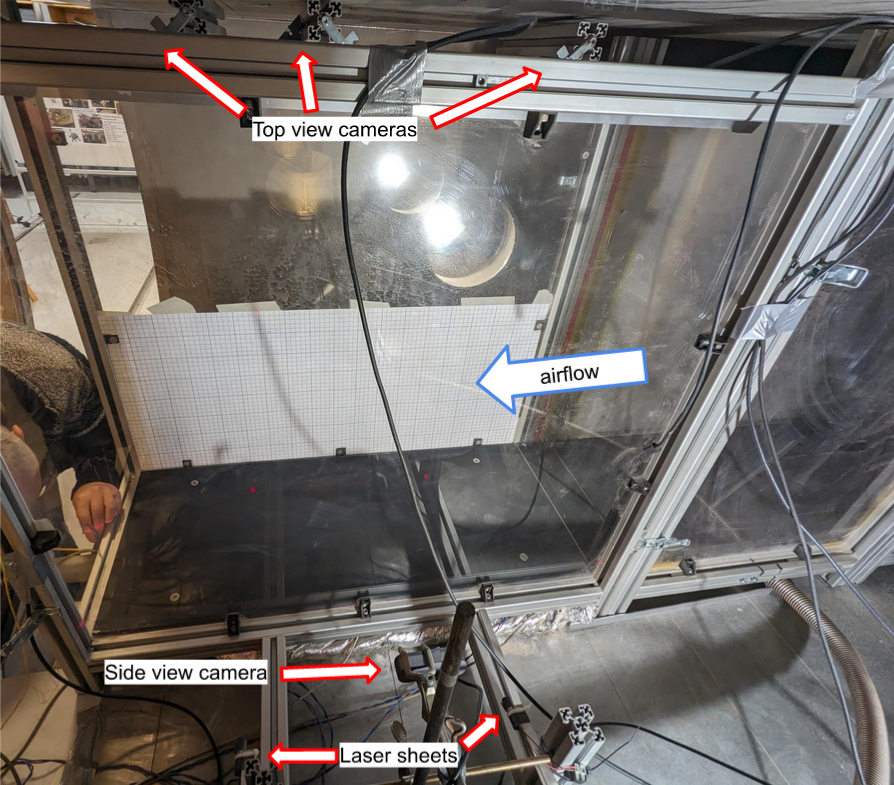
Figure 1: Experimental set-up of test-section inside the AWTS-II wind tunnel chamber.

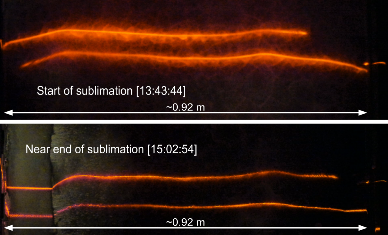
Figure 2: Comparison of initial and final laser sheet profilometry traces from experiment run 5, central top view camera


The experimental set-up of the test section inside the AWTS-II wind tunnel is shown in Figure 1, with the positions of cameras and laser sheets annotated. We monitored the ice surface evolution using a laser profilometry set-up, see Figure 2 for an example of the image data obtained. During some experiments, we observed how the ice surface developed structures with a length scale of roughly 20 cm, as can be seen for experiment run nr. 5 in Figure 2. During the oral presentation we will present the data obtained from numerical analysis of the laser sheet images and touch upon improvements of the experiment set-up and procedure that were implemented in our experiment campaign.

Another phenomenon that was observed during the experiments on CO2 ice was the appearance and migration of longitudinal frost streaks as well as transverse “frost waves” over the ice surface. An explanation for the observed behaviour includes slow growth of frost through direct deposition, until a critical thickness is reached. At this thickness the aerodynamic loads on a frost flake overcome its sticking force, causing it to break away from the surface and fly off in the flow. The cycle of frost growth and removal by flaking made both frost features appear to migrate downstream at speeds of several mm/min. In addition to sublimation waves, evolution frost features could provide additional information on wind intensity and direction.

ACKNOWLEDGMENTS: This work has been funded by the ANR grants Pluto’s SHERPAS ANR-23-CE49-0006-02 and Europlanet grant 22-EPN3-073. Europlanet 2024 Research Infrastructure has received funding from the European Union's Horizon 2020 research and innovation programme under grant agreement No 654208.

REFERENCES: Bordiec, M. et al. (2020) Earth & Sci. Reviews. Sci., 103350 ; Weller, G. (1969) Journal of Glaciology, 8(53) :277–284 ; Mellor, M. et al. (1989) Technical report, Hanover NH ; Bintanja, et al. (2001) Journal of Glaciology, 47(158) :387–396 ; Curl (1966) Transactions Cave Research Group of Great Britain, 7(2) : 121–160 ; Claudin, P. et al. (2017) J. Fluid Mech. 832, R2; Carpy, S. et al. (2023) Frontiers in Astronomy and Space Sciences, 10;

How to cite: Eckstein, P., Carpy, S., Claudin, P., Merrison, J., Iversen, J. J., Perret, L., and Bertrand, T.: Aarhus Wind Tunnel Simulator II experiments on CO2 ice show sublimation instability and frost migration, Europlanet Science Congress 2024, Berlin, Germany, 8–13 Sep 2024, EPSC2024-969, https://doi.org/10.5194/epsc2024-969, 2024.

15:10–15:15
Astrobiology
15:15–15:25
|
EPSC2024-212
|
On-site presentation
Laura Sánchez-García, Daniel Carrizo, and Victor Parro

The union territory of Ladakh (northern India) hosts different environment with astrobiological interest due to a number of characteristics derived from their high elevation, such as geothermal systems, desiccated environments, permafrosts, glacial geomorphologies or dust devil formations (Pandey et al., 2019). Located in the Indian Himalayas, this area lying mostly above 3500 (up to 5700) m.a.s.l. shows a cold desert-type climate, with lowered air pressures (~500-580 hPa), low oxygen, and high UV radiation. The rain-shadowed region offers various potential analogues to geological sites and water bodies that existed on the early (Noachian-Hesperian) Mars, such as the Puga geothermal field and Tso Kar.

The Puga hot springs are a boron-rich geothermal system located at the mouth of the Puga Valley, in the NW of the Himalayas (33º13´39.38´´N, 78º18´22.98´´E). This geothermal system occupies an area of 4 km x 1 km and exhibits a range of geothermal activity, including geysers, boiling pools, mud pots, and sulfur/boratic mineral deposits. The near-neutral water discharging at about 70ºC boils easily due to the high elevation and carries boron, an element thought to have played a key stabilizing role in the synthesis of RNA (Ricardo et al., 2004). Tso Kar is a fluctuating shallow (1–3 m depth), alkaline brine lake of high turbidity waters (TDS = 190.5 g L−1) of the Na–K–SO4-Cl type (Saxena & D´Amore, 1984). The desiccating lake is located at 4,535 m.a.s.l. (33º18´56.63´´N, 77º57´20.30´´E), in a cold desert environment with permafrost mounds around the palaeo-shoreline, a great daily temperature oscillation, and presence of ostracods (Kramer et al., 2014). The high-altitude lacustrine system contains two types of environments according to their water chemistry, dominated by saline waters near its shoreline or dominated by freshwater in areas receiving streams from glacial melting.

Both systems represent astrobiologically relevant settings, with potential as prebiotic (Puga hot springs) or Martian paleolakes (Tso Kar) analogs, whose biogeochemistry is poorly explored. Moreover, the particular physical-chemical properties of both settings provide interesting scenarios hosting extremophilic life, whose fingerprints may be environmentally representative and thus useful for the search for life traces in analogous Martian environments. Notably, the molecular remains of cell membranes upon degradation (i.e. lipid biomarkers) provide a powerful life-diagnostic tool that may be used to detect life for up to billions of years after death. This chemical recalcitrance is indispensable in the field of astrobiology given the harmfulness of the intense radiation outside of a protective atmosphere and the time span that the geological ages of planetary bodies encompass.

Thus, we conducted a research project to explore the forensic ability of lipid biomarkers to record representative life fingerprints of relevant Martian analogs. We investigated the lipid biomarker profile of various samples from both analogous scenarios from Ladakh. In Puga, we studied five biofilms of different appearance from two boiling pools, four fresh biofilms from the water immersed, inner wall of the pools (orange, pale green, red-purple, and dark green) and one crusty sample from the emerged shore (whitish). In Tso Kar, five samples were analyzed; two sediment samples from the saline-dominated lake shore (orange and dark grey sediments), one sediment from a freshwater stream flowing to the lake, and two crusty samples (whitish and yellowish) from the surrounding area around the lake. We aim to obtain a molecular biomarker record characteristic of each of the two analogous scenarios as a benchmark for recognizing traces of possible life in equivalent environments on Mars.

In both scenarios, lipid biomarkers were extracted, isolated and characterized at molecular and isotopic level. The prevailing biosources and metabolic pathways involved in their synthesis were identified and, according to their different molecular distribution, two biomarker patterns characteristic of each environment were built. While certain lipidic compounds were ubiquitous in both environments (C16 and C18 fatty acids, n-alkane C17, or chloropyll-derived phytol), some others were characteristically found in one or another system. For instance, bacterial hopanoids, cyclopropyl C21 fatty acid diagnostic of thermophiles (i.e. Aquificales), long chain polyunsaturated alkanes characteristics of non-sulfur bacteria (Chloroflexi), diols and branched alkanols were found only or in relatively higher concentration in Puga. In contrast, a relatively higher proportion of polyunsaturated fatty acids and sterols derived from eukaryotic organisms (e.g. algae, protozoa or fungi) was observed in Tso Kar. In addition, the Puga lipid biomarkers are generally more enriched in 13C (i.e. less negative δ13C) than those in Tso Kar, which illustrates also metabolic differences between the two Martian analogs with likely a relatively greater proportion of chemolithotrophs in the geothermal system. Overall, the concentration of lipid biomarkers and bulk biomass (as content of total organic carbon content or TOC) was lower in Tso Kar (0.4-1.1 % vs. 1.9-10 % TOC in Puga), illustrating the relatively lower biological productivity and/or biomarkers preservation in the hypersaline environment.

This work is the first to describe molecular and isotopic lipid fingerprints in these unexplored analogs, where the only existing organic data are of ATP or lipopolysaccharides (Pandey et al., 2019). These results are the basis for further biogeochemical research in the analog-rich Himalayan region.


Acknowledgements:

This work was funded by MCIN/AEI/10.13039/501100011033 and “ESF Investing in your future” through the grant RYC2018-023943-I (L.S.-G.) and projects PID2021-126746NB-I00 (V.P. and L.S.-G.) and PID2022-140180B-C21 (D.C.). The authors thank PhD. Siddharth Pandey, Pavithra Sekhar, Abul A. Khan, and Bharti Sharma from Amity University; Annalea Beattie from the Mars Society Australia; and Kunal Mehra from Cosmic Adventures for the organization and logistic assistance during the ESEP´22 exploration campaign to Ladakh, as well as Prof. Sudha Rajamani from the Indian Institute of Science Education and Research for her support in the field as an expert in biogeochemistry.


References:

  • Kramer et al. (2014). A late quaternary ostracod record from the Tso Kar basin (North India) with a note on the distribution of recent species. J. Paleolimnol. 51, 549–565, DOI 10.1007/s10933-014-9773-7.
  • Ricardo A. et al. (2004). Borate minerals stabilize ribose. Science 303:196.
  • Saxena V.K. & D´Amore F. (1984). Aquifer chemistry of the Puga and Chumatang high temperature geothermal systems in India. J. Volcanol. Geoth. Res. 21, 333-346.
  • Pandey S. et al. (2019). Ladakh: diverse, high-altitude extreme environments for off-earth analogue and astrobiology research. Int. J. Astrobiol., 1-21. https://doi.org/10.1017/S1473550419000119.

How to cite: Sánchez-García, L., Carrizo, D., and Parro, V.: Contrasting lipid biomarkers profiles in two prebiotic-astrobiological analogs from Ladakh (Indian Himalayas): a boron-rich geothermal system (Puga) and an alkaline brine lake (Tso Kar)., Europlanet Science Congress 2024, Berlin, Germany, 8–13 Sep 2024, EPSC2024-212, https://doi.org/10.5194/epsc2024-212, 2024.

15:25–15:35
|
EPSC2024-1101
|
ECP
|
On-site presentation
Lara Maldanis, Camila Areias, Fernando J. Gomez, Mathieu Thoury, and Mónica Sánchez-Róman

The Laguna Negra, a high-altitude hypersaline close-basin lake in the Andes of Northwest Argentina, presents a unique environment for studying the formation of microbialites (Gomez et al., 2014; Buongiorno et al., 2019). The extreme conditions like high UV radiation and salinity restrict multicellular life, allowing microbial activity as one of the drivers of carbonate precipitation. Oncolites samples, interpreted as a result from fluid mizing and biologically mediated nucleation (Buongiorno et al., 2019) and collected under Europlanet project have been analyzed for the search of chemical and mineralogical biosignatures. Synchrotron µ-X-Ray Fluorescence provided major-to-trace elemental distributions, revealing elements concentrated in stromatolitic laminae (e.g., Sr, Co, Rb, Mo, Pb), concentrated in not strictly stromatolitic laminations (eg., Fe, Mn, Mo, Ni, As, Pb, Zn), and contrasting with the elements widespread in the matrix (e.g., Ca, Cl, Br, K T, V). UV photoluminescence macroscopy highlighted laminations invisible in naked eye, providing also complementary information of chemical differences. Synchrotron scanning SAXS/WAXS maps provided additional information on mineral composition and crystallites shape and orientation. These combined results provide complementary chemical and mineralogical information for the characterization of the biotic and abiotic layers involved on the oncolites accretion, allowing us to define combination of characters specific to microbially-mediated precipitations. This work also opens the way for the multiscale assessment of mineral biosignatures of microbial precipitation in laminated rocks, from Earth or elsewhere.

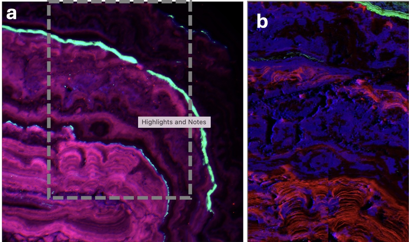
Figure 1. a) UV photoluminescence macroscopy of the Laguna Negra cross-cut oncolite excited at 385 nm. Emission collected at 571 nm (red), 708 nm (green) and 835 nm (blue). B) Synchrotron XRF map of Sr (red), Zn (green) and Ca (blue). Stromatolitic layers are rich in Sr, while Zn is restricted to outer, likely evaporitic layers.


References:

Buongiorno, J. et al. (2019) ‘Mineralized microbialites as archives of environmental evolution, Laguna Negra, Catamarca Province, Argentina’, Geobiology, 17(2), pp. 199–222. Available at: https://doi.org/10.1111/gbi.12327.

Gomez, F.J. et al. (2014) ‘Microbialites in a high-altitude Andean lake: Multiple controls on carbonate precipitation and lamina accretion’, Palaios, 29(6), pp. 233–249. Available at: https://doi.org/10.2110/palo.2013.049.

How to cite: Maldanis, L., Areias, C., J. Gomez, F., Thoury, M., and Sánchez-Róman, M.: Investigating chemical and mineralogical biosignatures in microbialites from Laguna Negra, Argentina, Europlanet Science Congress 2024, Berlin, Germany, 8–13 Sep 2024, EPSC2024-1101, https://doi.org/10.5194/epsc2024-1101, 2024.

Other analogues
15:35–15:45
|
EPSC2024-918
|
On-site presentation
Solmaz Adeli, Stephen Garland, Daniel Nunes, Sue Smrekar, Nils Mueller, Akin Domac, Giulia Alemanno, Christopher Hamilton, Gro Pedersen, Gael Cascioli, Christian Althaus, Ernst Hauber, Frank Trauthan, Oceane Barraud, Dennis Wendler, Rana Demirok, Shreya Chauhan, and Joern Helbert and the The VERITAS Science Team

Introduction:  The composition of lava fields on Venus and their alteration state are poorly constrained. The Venus Emissivity Mapper (VEM) [1, 2] on board NASA’s VERITAS [3] and its twin VenSpec-M on ESA’s EnVision will observe the surface of Venus in the NIR range through five atmospheric windows covered by six spectral bands (0.86 to 1.2 µm). These will enable studying the spectral characteristics of the Venusian surface, as well as lava types and possible alteration processes. To prepare for these missions and deepen our understanding of the emissivity spectral characterization of various volcanic rocks, we developed a field camera system analogous to VEM, named “VEMulator2.0” [4], and have undertaken in-situ measurements during the VERITAS expedition in Iceland, early August 2023. We relate these data to emissivity spectra of field samples acquired in the Venus chamber at the Planetary Spectroscopy Laboratory (PSL) of DLR-Berlin [1].

Iceland: The vegetation-free, geologically recent basaltic lava fields of Iceland make this area a prime Venus analog [5, 6]. Selected regions of interest for this campaign are [6]: Askja/Holuhraun in the highlands; Fagradalsfjall on the Reykjanes Peninsula. These ROIs offer a wide variety of surface textures, sand cover, and diverse fumarolic deposits, as well as macro- and micro- fractures. Fagadalsfjall is of particular interest for NIR team because of its very fresh lava flows (2021, 2022, and 2023), the still-cooling lava in the subsurface, and the recent fumarolic alteration products on the surface.

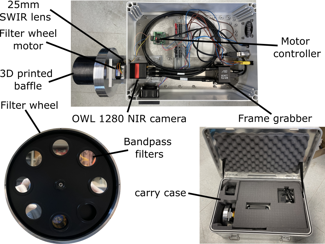
In-situ NIR data acquisition:  The VEMulator2.0 is an in-house built camera system equipped with an InGaAs detector – similar to the VEM flight model – and a filter wheel with six bandpass filters: 860, 910, 990, 1030, 1100, 1200 nm. A simpler version of this set-up had been successfully used in a field campaign in Vulcano, Italy [7]. In Iceland, data were collected in daytime (reflected sunlight) and at nighttime as emittance of the very hot (~100-480°C) lava flow at the active fissure of Litli-Hrutur.

Reflectance data. The main goal here is to understand the NIR spectral response of different basaltic surfaces in the spectral range of VEM. The sites were selected based on their surface texture and mineralogy. The goal was to image varying surface textures as well as contacts between different materials, such as sand cover over the 2014-2015 Holuhraun lava field, fumaroles and their deposits of Holuhhraun and Fagradalsfjall, tephra mantled lava flows near Askja, very fresh surfaces of Fagradalsfjall’s 2021-2023 fields, and near surface alteration due to escaping hot gases (including water vapor), exposed via fractures.

The imaged sites were scanned by the LiDAR team to obtain a high-resolution (millimeter-scale) DEM of the ROIs. These data will constrain surface geometry [8, 9]. GPS coordinates of the VEMulator location and the imaged targets have been collected, providing cm-scale precision on the camera-target distance. Two calibration targets were used in each imaged scene: one black surface as blackbody, and a gray disc. Both calibration targets were spectrally analyzed in the PSL laboratory before and after the field campaign, thus have known spectra that will help improving our data calibration processes.

Emittance data. The main goal here was to collect in-situ emittance of a fresh lava flow in the NIR spectral range of VEM. We imaged the hot lava surface (approximately 100-480°C) of the active vent of Litli-Hrútur where an eruption terminated two days prior to our arrival to obtain in-situ emittance of the basaltic rock at Venus temperature, after sunset. We used a FLIR thermal camera to find the hot spots, in collaboration with colleagues at the Univ. of Iceland. This allowed direct observation of surface temperature and identification of several cracks where hot gases were escaping from the cooling lava. All these collected data will provide detailed spectral information and a deeper understanding of the surface composition of the studied lava flows.

Sample collection. We collected samples from every imaged scenery by VEMulator. A total of ~60 kg of samples was transported to DLR in Berlin for post- processing and analyses using reflectance and emittance methods available there. All the samples are carefully labeled and stored in the sample collection laboratory at DLR-Berlin.

Laboratory measurements: Bi-directional and hemispherical reflectance spectra from 0.7-2.63 μm were collected using the Bruker Vertex 80V spectrometer at the PSL in DLR-Berlin. The data will be related to the daytime field data to better understand the NIR spectral response of surface material using the six spectral bands. We will collect emissivity measurements using the Venus chamber at PSL, to correlate with the in-situ nighttime data collected from Litli-Hrutur 2023 lava field. In addition, various Icelandic basalt samples will be analyzed in the Venus chamber with the goal to expand our datasets of emissivity spectra of Venus-analog materials as part of the VEM calibration plan [10].

Conclusion and future work: In the VERITAS expedition 2023 in Iceland, we collected in-situ NIR data using a Venus Emissivity Mapper (VEM) emulator (VEMulator2.0), and 60 kg of samples of Venus analog materials. The highlight of this work is the data we collected after sunset from the active fissure of Litli-Hrutur in the range of Venus surface temperature. We are currently analyzing the samples at PSL-DLR Berlin using the reflectance and emittance set-ups to correlate the laboratory data with the field data. This work will increase our understanding of emissivity of rock samples in hot temperature and will contribute in the VEM calibration plan.

Acknowledgments: SA, SPG, NM, AD received funding from the European Union's Horizon 2020 research and innovation programme under grant agreement No 871149. GC, EM was supported by NASA Planetary Science Division Research Program through the GSFC GIFT ISFM.

References: [1] Helbert, J., et al. (2022) SPIE. [2] Helbert et al. (2024) LPSC 55. [3] Smrekar S. (2022) IEEE Aerospace Conf.. [4] Garland S. et al. (2024) EPSC 2024.  [5] Nunes et al. (2023) LPSC 54. [6] Nunes et al. (2024) LPSC 55. [7] Adeli et al. (2023) SPIE. [8] Mazarico et al. (2024) LPSC 55. [9] Cascioli et al. (2024) LPSC 55. [10] Alemanno et al. (2023) SPIE.

How to cite: Adeli, S., Garland, S., Nunes, D., Smrekar, S., Mueller, N., Domac, A., Alemanno, G., Hamilton, C., Pedersen, G., Cascioli, G., Althaus, C., Hauber, E., Trauthan, F., Barraud, O., Wendler, D., Demirok, R., Chauhan, S., and Helbert, J. and the The VERITAS Science Team: Near-Infrared Data Acquisition for the VERITAS 2023 Iceland Field Campaign, Europlanet Science Congress 2024, Berlin, Germany, 8–13 Sep 2024, EPSC2024-918, https://doi.org/10.5194/epsc2024-918, 2024.

15:45–15:55
|
EPSC2024-1107
|
Virtual presentation
Caroline Freissinet, Valentin Moulay, David Boulesteix, Arnaud Buch, Alex Abello, Felipe Gomez Gomez, and Cyril Szopa

Europa and Enceladus, two ocean worlds in our solar system, are targets of high interest for astrobiology in the decades to come. Past space missions (Cassini-Huygens and Galileo) and recent observations with the Hubble Space telescope have revealed the presence of salts (sulfate and/or chloride) in the plumes of Enceladus and in the components of Europa’s surface (1-4). Future missions aiming at evaluating the habitability of Europa and Enceladus and detect potential traces of life on these satellites will face many challenges. One of them is the presence of salts in the oceans and therefore in the surface deposits material that would be sampled. These salts could degrade both the mechanical functioning of a chemical analysis instrument, and their analytical performances. The salts may also interfere with the sample preparation techniques (e.g., pyrolysis, derivatization or thermochemolysis).

Figure1: Chromatogram of a derivatized sample (from Lillo Lake) with DMF-DMA after evaporation of the water. I.S.: internal standard.

In this work, we explored natural samples coming from the hypersaline lacustrine system Tirez in Spain, an analogue sample of Europa and Enceladus ocean regarding salinity. The samples studied in this work were collected from seven salty lakes in 2019. They are in liquid state and characterized by a high concentration of Mg, Na, SO4 and Cl. Spectra obtained from Fourier transform infrared technique were similar to the Galileo spectral data for Europa (5). In addition, micro-organisms from the three domains (bacteria, archaea, eukaryotes) were identified in Tirez lake materials (6). Among the numerous samples collected during the field trip, this work focused on ten of them. These samples were analyzed in order to evaluate the potential impact of the salts on the gas chromatrography couple to mass spectrometer (GC-MS) instrument, and associated sample preparation techniques. The results showed that pyrolysis-GC-MS, derivatization-GC-MS and thermochemolysis-GC-MS are complementary analytical tools for the detection of organic molecules (Fig. 1). All the techniques used in this study allowed to detect and identify compounds directly related to the presence of microorganisms in the sample, such as archaea and eukaryotes. Nevertheless, it appeared that thermochemolysis was the best way to extract a large number of molecules by limiting their structural modification and thus facilitating their identification. The strict identification of the biological families remained complicated given the universality of numerous organic compounds amongst the phyla.


References: 1.  T. B. McCord, Hydrated salt minerals on Europa's surface from the Galileo near-infrared mapping spectrometer investigation. Journal of Geophysical Research 104,  (1999).

2.         Waite, Cassini Ion and Neutral Mass Spectrometer Enceladus Plume composition and Structure. Science 311,  (2006).

3.         S. K. Trumbo, M. E. Brown, K. P. Hand, Sodium chloride on the surface of Europa. Science Advances 5, eaaw7123 (2019).

4.         S. K. Trumbo, et al., A New UV Spectral Feature on Europa: Confirmation of NaCl in Leading-hemisphere Chaos Terrain.  (2022).

5.         O. Prieto-Ballesteros, Tírez Lake as a Terrestrial Analog of Europa.  (2003).

6.         L. Montoya et al., Microbial community composition of Tirez lagoon (Spain), a highly sulfated athalassohaline environment. Aquatic Biosystems 9, 19 (2013).

How to cite: Freissinet, C., Moulay, V., Boulesteix, D., Buch, A., Abello, A., Gomez Gomez, F., and Szopa, C.: Organic matter in samples from hypersaline Tirez lake (La Mancha, Spain); a projection into Europa and Enceladus analyses., Europlanet Science Congress 2024, Berlin, Germany, 8–13 Sep 2024, EPSC2024-1107, https://doi.org/10.5194/epsc2024-1107, 2024.

15:55–16:00

Posters: Tue, 10 Sep, 10:30–12:00 | Poster area Level 2 – Galerie

Display time: Tue, 10 Sep, 08:30–Tue, 10 Sep, 19:00
Chairpersons: Fulvio Franchi, Barbara Cavalazzi, Jonathan Merrison
Mars analogues - general
P1
|
EPSC2024-365
|
On-site presentation
Alessandro Frigeri, Maria Cristina De Sanctis, Francesca Altieri, Eleonora Ammannito, Simone De Angelis, Marco Ferrari, Lorenzo Rossi, Giovanni Valentini, and the Ma_MISS Team

The ESA ExoMars mission, which will look for traces of past and present life on Mars, is planned for 2028. The Rosalind Franklin rover will land within a 115 by 15 km ellipse centered at Oxia Planum, a gently sloped broad plain connecting the outlet of Cogoon Vallis channels with Chryse Planitia.  

The Rosalind Franklin rover is equipped with a state-of-the-art drilling system capable of reaching depths 2 meters below the surface.    Next to the tip of the drill is the miniaturized spectrometer Ma_MISS, which will record the compositional variation along the drilling hole.    The combination of the advanced tool and instrument onboard Rosalind Franklin will provide us with unprecedented insights into the shallow subsurface of Mars, which we know little about but could potentially harbor life.

The Ma_MISS scientific team is preparing for the ExoMars mission to Mars by studying terrestrial analogs in the field and the laboratory.   We are collecting samples from a pool of possible geological environments expected at Oxia.   We are using the recently published geologic map of the Oxia Planum ExoMars landing ellipse as a reference to select analog samples to bring to the laboratory. The samples collected in the field are stored and cataloged at the Istituto di Astrofisica e Planetologia Spaziali (IAPS) in Rome, Italy. The DAVIS (Drill for Analogues and Visible-Infrared Spectrometer) laboratory setup at IAPS will be used to drill and do compositional mapping on the samples.

Here, we present the case of a set of samples acquired in a fluvial-lacustrine environment showing fossilized sedimentary structures representing an optimal environment for microbial life.    With DAVIS, we simulate the combined action of the Rosalind Franklin drill and Ma_MISS in-hole compositional analysis, building a library of experiments with different geologic settings in preparation for the actual mission.

Acknowledgments:  This work is supported by the ASI-INAF Mars Exploration agreement code 2023-3-HH_0.


How to cite: Frigeri, A., De Sanctis, M. C., Altieri, F., Ammannito, E., De Angelis, S., Ferrari, M., Rossi, L., Valentini, G., and Team, T. M.: Rock Specimens for Laboratory Drill and Compositional Testing for the Ma_MISS experiment onboard ESA/ExoMars Rosalind Franklin Mission to Mars, Europlanet Science Congress 2024, Berlin, Germany, 8–13 Sep 2024, EPSC2024-365, https://doi.org/10.5194/epsc2024-365, 2024.

P2
|
EPSC2024-695
|
ECP
|
On-site presentation
Laura Romero, Javier Suarez, Oscar Ojeda, Yael Mendez, and Luis Ochoa

1. Introduction

The development and validation of specific procedures for scientific activities in planetary analog sites, whether natural or artificial, are key to ensure the success, effectiveness, and safety in future extraterrestrial human exploration missions (Foucher et al. 2021). However, this has been developed in facilities and sites generally inaccessible for the Latin American scientific community and constitutes an obstacle for contributing to the study in analogs.

This work presents the geomorphological assessment of three representative landforms on Mars: a lava flow field at the southwestern base of Olympus Mons (13.18° N, 134.95 W), a lacustrine deposit in a paleolake within an impact crater near Maja Valles (5.33° N, 58.58° W) and the impact crater Catota in Acidalia Planitia (51.65° N, 25.98° W); which were used to test the analogy of morphological simulations of these landforms created in the first artificial Mars analog facility in Latin America, called "Rock Yard" within the Simulated Analog Space Exploration Habitat in Colombia (HAdEES-C).

2. Data

In order to carry out the geomorphological mapping and interpretation, images from the High Resolution Imaging Science Experiment (HiRISE), Mars Reconnaissance Orbiter (MRO) Context Camera (CTX) and the High Resolution Stereo Camera (HRSC) as well as digital terrain models available were collected and processed for each of the Mars’s sites, in addition to basemaps of Mars.

3. Results

3.1. Mapping of landforms

For each of the real sites on Mars, a geomorphological map was made and interpreted.

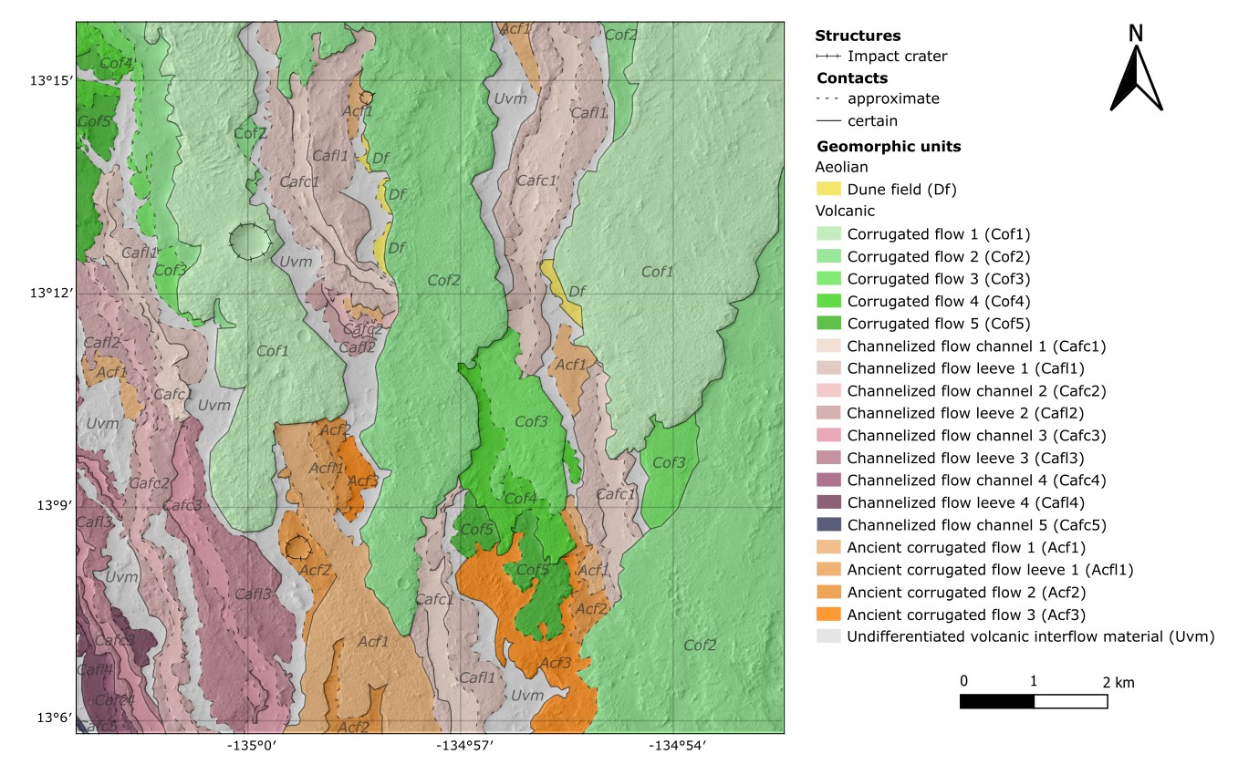
The area in the southernmost part at the base of Olympus Mons forms a flow field in an anastomosing network (Morris & Tanaka, 1995). Flows are broadly divided into three categories according to their morphology and stratigraphy (Peters et al. 2021). Corrugated flows (Cof) are the younger flows characterized for their rough surface texture resembling ‘a’a¯ flows in Hawaii (Hargitai & Kereszturi, 2015). Underlying are the Channelized flows (Caf), numerous and narrower flows with a smooth-textured central channel and rough-textured levees. And Ancient corrugated flows (Acf) are the oldest flows. These define at least three different episodes of volcanic activity with different emplacement styles. Figure 1 shows this map.

The possible paleolake is in a ~37 km complex impact crater and forms a closed-basin lake (Cabrol & Grin, 1999) with a >30 km long incised Inlet valley (Iv) (Goudge et al. 2015) but no outlet valley. It has an inlet continuous delta observed extending over 4 km, where different depositional events were identified based on the overlapping Deltaic slopes (Ds). The basin floor is nearly level given that the lacustrine deposits filled the topographic irregularities, but only resurfacing units are visible: Volcanic mantles (Vm) at east, and dark and finer Eolian deposits (Ed) at west.

The impact crater has a diameter of 1.3 km, is bowl-shaped and its rim is raised. The inner flank shows a Spur-and-gully (Sg) morphology (Watters et al. 2015) in the upper part and talus deposits in the lower part. The outer flank is covered by the preserved ejecta that divides in Continuous ejecta (Ec) and Discontinuous ejecta (Ed).

Figure 1: Geomorphological map of lava flows at the base of Olympus Mons.

3.2. Analogue model constructed

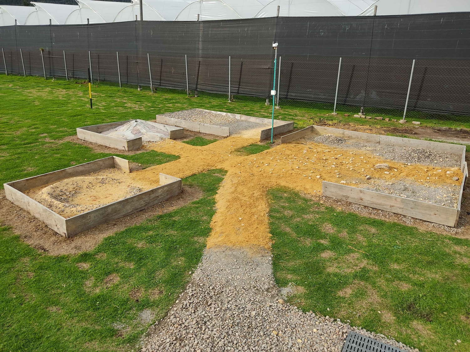
Following a low-cost and open science concept, the Rock Yard was built with two 4 m2, one 8 m2 and 18 m2 interconnected modules, each one with a specific landform made with easily accessible local construction materials to mechanically simulate the Martian soil. The cost did not exceed 400€ and it was built in 8 days. Figure 2 contains a photograph of the complete Rock Yard.

Figure 2: Rock Yard at HAdEES-C.

4. Discussions and conclusions

The recreated landforms represent approximately 44% of the Martian surface compared to the latest defined geological units on Mars defined by Tanaka et al. (2014). Several of the defined geomorphological units can indeed be correlated with the structures present in the simulations of the Rock Yard, and the main differences correspond to inconsistencies due to the scale, and the impossibility to recreate secondary surface processes on Mars that have modified the original landforms. Therefore, the Rock Yard constitutes a characterized facility whose main parameters are controlled with a geomorphologic analogy that is coherent within the limits of the scale of representation and the composition of the materials.

Work is currently underway to expand the area to include simulations of other landforms and generate interactions between them that represent a realistic geological history, to make this space a more rigorous scientific representation of the structures and processes on Mars. In any case, while being a first approximation to the design and construction of these facilities in Colombia, the Rock Yard is already a compact, representative, and accessible geologic analog. One that allows research, outreach, and educational activities that will contribute to the local production of scientific knowledge, and to bring the study of analogues to a wider public.

5. Acknowledgements

This project has received funding from Cydonia Foundation and GMAS and initiated as an undergraduate geology dissertation in the National University of Colombia.

6. References

  • Cabrol, N., & Grin, E. (1999). Distribution, Classification, and Ages of Martian Impact Crater Lakes. Icarus, 142, 160–172.
  • Foucher, F., Hickman-Lewis, K., Hutzler, A., Joy, K. H., Folco, L., Bridges, J. C., Wozniakiewicz, P., Martínez-Frías, J., Debaille, V., Zolensky, …, Westall, F. (2021). Definition and use of functional analogues in planetary exploration. Planetary and Space Science, 197.
  • Goudge, T., Aureli, K., Head, J., Fassett, C., & Mustard, J. (2015). Classification and analysis of candidate impact crater-hosted closed-basin lakes on Mars. Icarus, 260, 346-367.
  • Hargitai, H., & Kereszturi, Á. (2015). Encyclopedia of Planetary Landforms. Springer. doi:10.1007/978-1-4614-3134-3.
  • Morris, E., & Tanaka, K. (1995). Geologic Maps of the Olympus Mons Region of Mars. USGS Astrogeology Science Center.
  • Peters, S. I., Christensen, P. R., & Clarke, A. (2021). Lava Flow Eruption Conditions in the Tharsis Volcanic. Journal of Geophysical Research: Planets, 126.
  • Watters, W., Geiger, L., Fendrock, M., & Gibson, R. (2015). Morphometry of small recent impact craters on Mars: Size and terrain dependence, short-term modification. J. Geophys. Res. Planets, 120, 226–254.

How to cite: Romero, L., Suarez, J., Ojeda, O., Mendez, Y., and Ochoa, L.: Mapping of Martian geomorphologies as a contribution to construct the first artificial analog in Colombia, Europlanet Science Congress 2024, Berlin, Germany, 8–13 Sep 2024, EPSC2024-695, https://doi.org/10.5194/epsc2024-695, 2024.

P3
|
EPSC2024-830
|
On-site presentation
Katrin Stephan, Kristin Rammelkamp, Susanne Schröder, Mickael Baque, Alessandro Pisello, Klaus Gwinner, Frank Sohl, and Vikram Unnithan

The ongoing volcanic activity by subareal and submarine fumaroles on Vulcano (Eolian Islands, Italy) provides extreme acid alteration conditions of volcanic deposits, which also have been a key process at local and regional scales throughout Martian geologic history. This makes the study of volcanic deposits on Vulcano a perfect spectral analog to constrain the conditions of acidic alteration with respect to Mars. During the fifth International Summer School held on Vulcano (Eolian Islands, Italy) in June 2019 lava rocks that are still actively altered by volcanic sulfur-rich gases emanating through cracks and caves pervading the study area were investigated using a portable spectrometer working in the visible and near-infrared (VIS-NIR) wavelength range (Stephan et al., 2022). Spectral measurements of different phases of altered lava rock from relatively un-weathered lava rocks to fully altered portions displaying a reddish, yellowish to whitish surface and particular crystal growth revealed characteristic alteration minerals such as jarosite and alunite. These minerals are believed to directly result from the interaction between the surface of the lava rock with the volcanically-derived acid fluids by remobilization of material from the lava rock constituting the main elements in the new mineral phases. Similarly, the residual siliceous material is progressively reddened by iron and the calcium of the lava rock is consumed in the formation of gypsum.

This study has now been extended by the analysis of corresponding data acquired by laser-induced breakdown spectroscopy (LIBS) and Raman spectroscopy, a triple combination, which significantly improved our results. In general, LIBS data confirm the presence of most of the chemical elements that make up the minerals detected at the wavelength range of the VIS-NIR spectrometer such as Si, Fe, Na, K, Ca, Al and S. Even more, the relative intensities of the detected emission lines generally support the interpretation of the VIS-NIR spectra. Thus, for example, LIBS data show that Fe (II) emission lines are strongest, where Fe-rich sulfate jarosite or silica residuals dominate the corresponding VIS-NIR data. Regarding the Al (I) emissions, no clear trend can be recognized. Possibly, alunite is not that dominant in locations, where the mineral is implied by VIS-NIR spectra. Nonetheless, both Na and K are confirmed by emission lines in the LIBS spectra and thus support the findings derived from the VIS-NIR as well as Raman data that jarosite and alunite occur in both varieties. Only LIBS data, however, show that both, Na and K are already existent in the un-weathered lava rock, which cannot be recognized in neither the VIS-NIR nor Raman spectra. LIBS data also indicate the existence of Ca (II) already in places, where gypsum has not been exclusively identified by VIS/NIR spectra. Intriguingly, LIBS data also nicely show the presence of Sr and Ti implying that Sr and Ti-bearing minerals such as Celestite and Anatase, respectively, could exist in the study area. Such minerals could not be detected in the VIS-NIR spectra. These minerals are relatively transparent in this wavelength range and thus their spectral signature could possibly be easily masked by the identified sulfates. Indeed, both minerals could be identified in the data acquired by the Raman instrument. Finally, both, LIBS as well as Raman data show no hint of the occurrence of the phosphate mineral apatite in the study area, such as indicated by the VIS-NIR spectra. An explanation could be that apatite only occurs very locally and is only detectable by the VIS-NIR spectrometer because of the largest field of view of its measurements. Thus, not only the different spectral range, but also the different field of view of the different instruments have to be considered when interpreting the data. 

In summary, the results of every instrument nicely complement each other and enable to reach a more complete view of the geologic evolution of the study area. Even more, the multi-instrument approach helps to evaluate the usage of each instrument with respect to the exploration of specific geologic settings. In order to avoid misinterpretation of spectral variations, however, special care has to be taken to align the measurement locations of the different spectral instruments due to different IFOVs of the instruments and to ideally scan the same area with all spectral instruments. In contrast to field measurements of planetary analogs on Earth this can be more easily applied to planetary mission data with the knowledge of geometric information of each instrument of the spacecraft’s payload.    

How to cite: Stephan, K., Rammelkamp, K., Schröder, S., Baque, M., Pisello, A., Gwinner, K., Sohl, F., and Unnithan, V.: Combined VIS-NIR, LIBS and Raman investigation of altered volcanic deposits of Vulcano island/Sicily, Europlanet Science Congress 2024, Berlin, Germany, 8–13 Sep 2024, EPSC2024-830, https://doi.org/10.5194/epsc2024-830, 2024.

P4
|
EPSC2024-982
|
ECP
|
On-site presentation
|
Tim Becker, Florence Chioma Onyeagusi, Jens Teiser, Teresa Jardiel, Marco Peiteado, Olga Munoz, Julia Martikkainen, Juan Carlos Gomez Martin, Jonathan Merrison, and Gerhard Wurm

We present laboratory measurements for the charge distribution of dust to sand sized particles that are ejected in small-scale sand grain impacts, simulating saltation bombardement events on the Martian surface. Using a high speed camera, tracking particles within an electric field, we determined charges of individual grains characterizing single grain impacts. While the charge of small particles seems to have random polarity, larger particles show some bias toward positive charges. Such preference could lesd to a charge separation in the free air stream and thus to the establishment of an electric field near the surface, aiding further lifting as e.g. proposed by Renno&Kok 2008* and Holstein-Rathlou et al. 2010**.

*Renno, N. O., & Kok, J. F. 2008, SSRv, 137, 419, doi: 10.1007/s11214-008-9377-5
**Holstein-Rathlou, C., Gunnlaugsson, H. P., Merrison, J. P., et al. 2010, Journal of Geophysical Research: Planets, 115, doi: 10.1029/2009JE003411

How to cite: Becker, T., Onyeagusi, F. C., Teiser, J., Jardiel, T., Peiteado, M., Munoz, O., Martikkainen, J., Gomez Martin, J. C., Merrison, J., and Wurm, G.: Charge Distribution of Ejected Particles after Impact Splash on Mars: A Laboratory Approach, Europlanet Science Congress 2024, Berlin, Germany, 8–13 Sep 2024, EPSC2024-982, https://doi.org/10.5194/epsc2024-982, 2024.

Mars analogues - Makgadikgadi pans
P5
|
EPSC2024-406
|
On-site presentation
Mebatseyon Shawel, Ame Thato Selepeng, Boniface Kgosidintsi, and Fulvio Franchi

The Makgadikgadi pans (playa lakes) in Botswana form the largest salt pan system in the world. The formation of these pans is related to a tectonic activity possibly linked to the East African Rift System, which caused the subsidence and infilling of a large endoreic basin. Changes in climate and tectonics eventually led to the drying up of the ancient lake, leaving behind the salt pans we see today. The basin consists of two major pans, namely Sua and Ntwetwe pans.

These pans are mostly flat, at an elevation of ca. 908 m a.s.l., but feature distinct geomorphic elements such as mounds and paleo- delta and shorelines that can be easily identified through satellite imagery (Franchi et al., 2020). In the western part of the Ntwetwe pan, there are numerous mounds, several hundreds of meters wide and with an average height of 5m (Figure 1). These mounds are primarily composed of fine-grained sands, calcite nodules and ostracods shells (Franchi et al., 2022). While several theories have been proposed for their origin, the internal sedimentary structure of these geomorphic features remains unknown.

On Mars, conical mounds are significant morphological features that have been observed and mapped in various regions. The Noachian-Hesperian climate change on Mars resulted in the deposition of crudely layered sediments in the equatorial region, where fluctuations in groundwater played a crucial role. These layered sediments, known as Equatorial Layered Deposits (ELDs), contain numerous mounds that were exposed due to impact craters (Pondrelli et al., 2015).

A relict fan delta was identified by previous studies in the southern Ntwetwe Pan (Figure 2). The delta is linked to the paleo-Boteti river, one of the main seasonal rivers that fed the basin before desiccation and shows a system of inverted channels and polygonal fractures (Figure 2) and was considered as a suitable analogue of the paleo-drainage systems on Mars.

The objective of this study is to investigate the mounds and the relict fan delta in the Ntwetwe pan using geophysical methods, particularly Ground Penetrating Radar (GPR). By employing GPR, we aim to image the internal structure of these mounds and other geomorphic features, with the ultimate goal of understanding the formation and preservation of similar structures on the Martian surface.

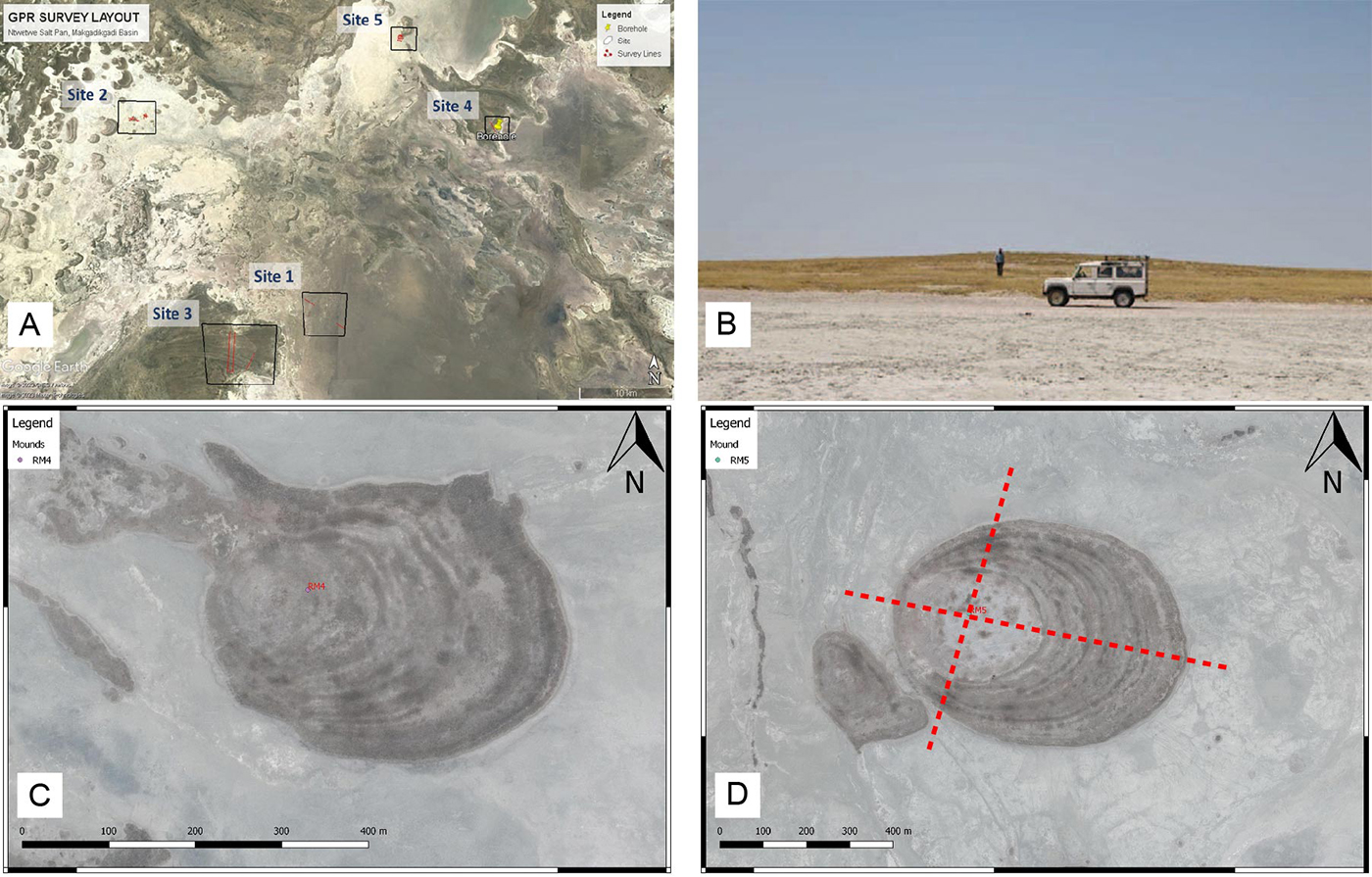
Several sites within the Ntwetwe pan were selected for GPR survey, primarily along east-west and north-south profiles (Figure 1). The survey was done using Mala ProEx acquisition system. The system uses rough terrain antennae with an in-line configuration for 30 and 50MHz frequencies. Over a period of six days, approximately 23 kilometers of GPR data were collected. Most of the surveys utilized 50MHz antennas, while three lines were acquired using both 50MHz and 30MHz antennas to attain penetration depth as well as resolution. Preliminary results indicate clear imaging of the top 15 meters over the mounds and delta sites. In addition, 2D profiles were acquired over structures previously mapped using aeromagnetic and Electrical Resistivity Tomography (ERT) methods (Schmidt et al., 2023).

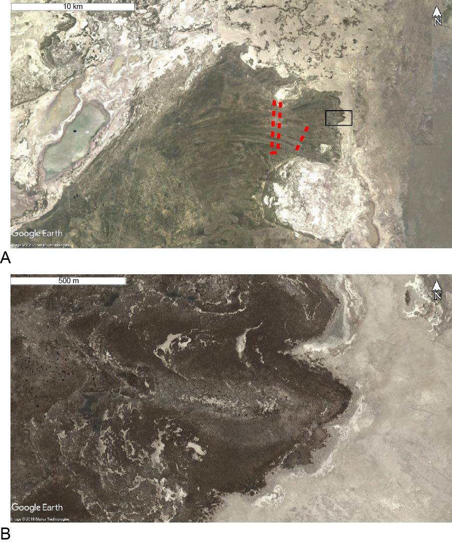
Here we focus mostly on the results coming from the mounds in the western part of the study area and on a delta found close to center of the basin. Five (5) lines were acquired over mound structures RM-4 and RM-5 (Figure 1). These mounds were previously studied using cores drilled to the bottom of the mounds (Franchi et al., 2022) and geological log from this study were used to correlate reflections with geological contacts. Two lines were acquired over RM-5 and three lines were acquired over RM-4 with a general E-W and N-S trend. Three (3) lines were acquired over the relict fan delta (Figure 2). The survey was designed to cross distributary channels at high angles over the delta plain. A total of four lines were acquired over the delta with three lines trending N-S in different parts of the delta and one E-W line connecting cross lines (Figure 2).

The preliminary processing steps applied to data include correction applied to setup geometry, recover gain and suppress noise and adjust static shifts. The result from the survey has shown that the GPR data was effective in mapping up to a depth of ~15m in the study area. The imaging result shows better quality over the studied geomorphic features allowing to describe the internal stratigraphy of the mounds and the role of groundwater in their formation. This has important repercussions on the discussion of groundwater upwelling forming layered deposits and mounds in the equatorial region of Mars.


REFERENCES:

Franchi, F., MacKay, R., Selepeng, A.T., Barbieri, R., 2020. Layered mound, inverted channels and polygonal fractures from the Makgadikgadi Pan (Botswana): possible analogues for Martian aqueous morphologies. Planetary and Space Science 192, 105048. Doi: 10.1016/j.pss.2020.105048

Franchi F., Cavalazzi B., Evans M., Filippidou S., Mackay R., Malaspina P., Mosekiemang G., Price Alex, Rossi Veronica, 2022. Late Pleistocene–Holocene Palaeoenvironmental Evolution of the Makgadikgadi Basin, Central Kalahari, Botswana: New Evidence From Shallow Sediments and Ostracod Fauna. Frontiers in Ecology and Evolution 10, doi: 10.3389/fevo.2022.818417

Pondrelli, M., Rossi, A.P., Le Deit, L., Fueten, F., van Gasselt, S., Glamoclija, M., Cavalazzi, B., Hauber, E., Franchi, F.,Pozzobon, R., 2015. Equatorial Layered Deposits in Arabia Terra, Mars: facies and process variability. GSA Bulletin 127 (7-8), 1064-1089. Doi: 10.1130/B31225.1

Schmidt, G., Luzzi, E., Franchi, F., Selepeng, A.T., Hlabano, K., Salvini, F., 2023. Structural influences on groundwater circulation in the Makgadikgadi salt pans of Botswana? Implications for martian playa environments. Front. Astron. Space Sci. 10:1108386. doi: 10.3389/fspas.2023.1108386


FIGURE CAPTIONS:

Figure 1. A) Location of all the GPR line completed during the survey, sites are numbered 1 to 5. Here we focus on sites 2 (the mounds) and 3 (the relict fan delta). B) Field view of the mounds in the Ntwetwe pan (from Franchi et al., 2020). C-D) Satellite view of mound RM4 and RM5 (from Franchi et al., 2020). Red lines in D show the approx. direction of the GPR lines.

Figure 2. A) The fan delta in the southern Ntwetwte Pan, showing in red the GPR lines. B) Polygonal structures on the delta. Modified from Franchi et al., 2020.

How to cite: Shawel, M., Selepeng, A. T., Kgosidintsi, B., and Franchi, F.: Investigation of geomorphic features in the Makgadikgadi Basin (Botswana) using Ground Penetrating Radar: implications for the formation of Martial surface landforms, Europlanet Science Congress 2024, Berlin, Germany, 8–13 Sep 2024, EPSC2024-406, https://doi.org/10.5194/epsc2024-406, 2024.

P6
|
EPSC2024-590
|
ECP
|
On-site presentation
Characterizing clay minerals in the Makgadikgadi Pans (Botswana): terrestrial analogue for Mars playa deposits
(withdrawn after no-show)
Katlo Oromeng, Trhas Hadush Kashay, Fulvio Franchi, and Barbara Cavalazzi
P7
|
EPSC2024-743
|
On-site presentation
Katrin Stephan, Ernst Hauber, Fulvio Franchi, Kristin Rammelkamp, Mickael Baque, Susanne Schröder, and Aobakwe Motlhasedi

The Makgadikgadi Salt Pans in northern Botswana offer a unique opportunity to study the mineralogy of evaporates and clays derived from fluvio-lacustrine sediments in their geological context. During the rainy season the pans are usually filled with water, but the level never exceeds ~50 cm in height. During the dry season, from June to October, an expanse of salt deposits dries in the sun above a layer of clay and sand. The pans are completely flat. However, locally, some exposed rocks such as granite, dolerite, exist. A field campaign taking place in August 2022, funded by Europlanet 2024 RI (grant agreement No 871149) was performed in order to 1) obtain a horizontal profile of the mineralogical diversity throughout the Pans from the topographic center to the rim/shoreline; and (2) investigate variations in the mineralogical composition of the evaporates and clays due to the influence of neighboring and/or underlying (bedrock) units. Spectral measurements were performed directly in the field with a portable visible/near-infrared spectrometer that samples the surface in the visible and near-infrared (VIS-NIR) wavelength range between 0.35 and 2.5µm. This range is known to be best suited for mineralogic research and most commonly used on planetary spacecrafts.

The acquired spectra reveal that salts dominate a more or less fresh, white to light brown, several mm-thick uppermost crust throughout the pans. They are particularly prominent where the salts themselves or at least the clays underneath this layer are still wet from the rainy season. The special shape of the water-related feature at 2 µm implies that sodium hydrogen carbonates such as trona dominate the salt layer. Although halite should be also present, its spectral signature might be masked by the signature of trona. In the wettest location, a thin greenish layer of organic material has been found, which causes a characteristic feature near 0.7 µm. In regions that have been dry for a prolonged period, clays such as montmorillonite dominate over salts. Bed rocks that are in direct contact with the pan deposits often show a distinct greenish color. Spectra of these rocks are dominated by glauconite, sometimes in combination with illite, which possibly develop as a consequence of alteration of sedimentary deposits associated with low-oxygen conditions. The collected spectra in combination with the knowledge of their geologic context will be extremely useful for identifying and mapping similar environments on Mars by spectrometers working in the visible-near infrared (VNIR) wavelength range such as Mars Express OMEGA and MRO CRISM.

In addition, spectra acquired in the field provide the spectral endmembers, which are now used to classify the currently available data of the pans provided by the Environmental Mapping and Analysis Program (EnMAP) of the German hyperspectral satellite mission. EnMAP data cover the same wavelength range in the VIS-NIR as the field instrument and measured major portions of the pans at the same seasonal period of the year. We present the distribution of the minerals detected in the field across the observed areas.

Furthermore, samples collected in the field are now analyzed by additional types of spectroscopy such as laser-induced breakdown spectroscopy (LIBS) and Raman spectroscopy, a triple combination, which has proven to significantly enhance the scientific potential for studying the mineralogy of planetary analog materials (Stephan et al., 2022). Results of this multi-instrument approach will be presented.

References:

Stephan, S. Schröder, M. Baque, K. Rammelkamp, K. Gwinner, J. Haber, I. Varatharajan, G. Ortenzi, A. Pisello, F. Sohl, R. Jaumann, L. Thomsen, V. Unnithan (2020): Multi-spectral investigation of planetary analog material in extreme environments – alteration products of volcanic deposits of Vulcano/Italy, LPSC 2020, 2411.

How to cite: Stephan, K., Hauber, E., Franchi, F., Rammelkamp, K., Baque, M., Schröder, S., and Motlhasedi, A.: Spectral field study of the Makgadikgadi Salt Pans in Botswana as a planetary analog for ancient fluvio-lacustrine environments on Mars, Europlanet Science Congress 2024, Berlin, Germany, 8–13 Sep 2024, EPSC2024-743, https://doi.org/10.5194/epsc2024-743, 2024.

P8
|
EPSC2024-991
|
On-site presentation
Maxime Pineau, Simon Gouzy, Vassilissa Vinogradoff, John Carter, and Benjamin Rondeau

Introduction: Hydrated silica (SiO2,nH2O) occurs in various forms depending on the geological context, and as such are good tracers for paleoenvironmental reconstitutions on Earth and Mars (e.g. [1,2]). Their potential to sequester and preserver organic matter further makes them prime exobiological targets [3]. Observed on Mars since over a decade [4], hydrated (opaline) silica minerals have been used to describe aqueous geological processes in diverse regions. However, geological origins of some deposits are still misunderstood because no satisfactory terrestrial analogues were found (e.g. [5]). Likewise, the exobiological potential of hydrated silica as a prime host of Mars organic matter remains to be fully ascertained. The Makgadikgadi Salt Pans show a very high potential to be considered as a terrestrial analogue site for Mars ancient aqueous environments, especially in fluvio-lacustrine geological settings [6,7]. A field trip was conducted in 2023 to study more specifically the silica-rich environments which were reported in the area [8-10].

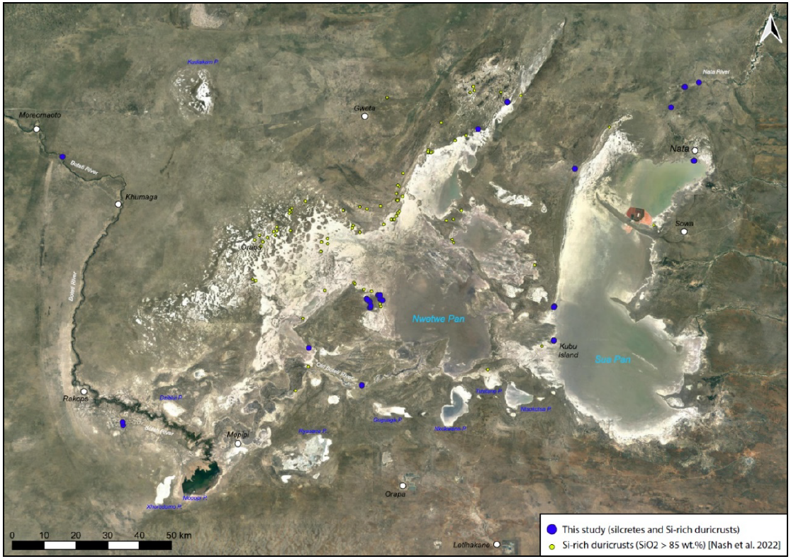
Samples and method: 15 locations in the Makgadikgadi Pans area (Nwetwe and Sua Pans), along the Nata, Old Boteti and Boteti rivers were visited (Fig.1). We sampled ≈80 silica-rich rocks (i.e., silcretes) in a (paleo) fluvio-lacustrine geological context. Some visible-near infrared spectra of the surface of the samples were acquired using an ASD FieldSpec portable spectrometer (0.35-2.5µm) to evaluate the mineralogy of the rocks. A detailed analysis of the mineralogy of the samples was conducted in the lab, so far including: optical microscopic observation on raw samples and extracted thin sections, VNIR hyperspectral imaging (402-2504 nm), Raman, electron microscopy and geochemical analysis (EDS).

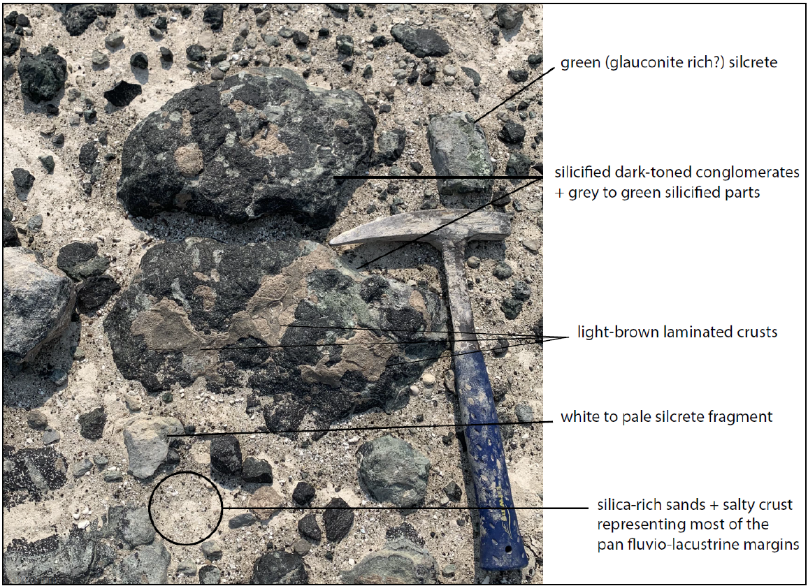
Results in the field: In-field analysis using the portable field VNIR spectrometer suggested the ubiquitous presence of hydrated silica and phyllosilicate minerals. Based on spectroscopic and macroscopic observations in the field, most of the samples are silicified/indurated clastic sedimentary rocks and consist of coarse-grained quartz-rich sandstones and conglomerates with a fluvio- lacustrine origin (Fig. 2). Clasts in the sedimentary rocks can be of various types, fragments of quartz pebbles or sometimes opaline silica to detrital fragments of other silica-rich clastic sedimentary rocks. Matrix between the clasts is of different nature from one sample to another; it can be either opaline or microcrystalline silica and sometimes consists of clay-rich cemented materials. Depending on the nature of the clasts and matrix, the samples exhibit different colours: from white to creamy-white shades, from dark-toned shades of green, brown, and black. Samples consisting of translucent opaline and/or microcrystalline silica plates were also taken. Field observations and spectral analyses confirm the large amount of amorphous to (micro-) crystalline silica in the samples, along with different clays and salts. This type of mineralogy, possibly indicating a formation in a fluvio-lacustrine context in semi-arid environments, is reminiscent of some silica-rich deposits on Mars in locations interpreted as potential paleo-lakes [e.g. 2,5].  

Results in the lab: VNIR and Raman analysis permit us to identify several mineral phases that are present in our samples. Microcrystalline silica is present in most of the samples along with various phyllosilicatesand sulfates in mixtures with silica or as (clayey) salty crusts. The presence of the mineral glauconite, suggested in the literature for these silcretes, giving this pale green colour, is verified in our spectra and support the fluvio-lacustrine origin in a semi-desertic environment for these silica deposits. Microscopic and EDS analysis show that hydrated silica is found in several types of contexts, ranging from inherited in the sediments to later-stage reprecipitation in voids.

Perspectives: Laboratory analyses have recently begun and a systematic comparison between samples is underway to find trends between geological setting, composition, and lithology. Of particular interest we are investigating how the whole-rock VNIR spectra relate to the fine distribution and abundances of the minerals comprising the rock. This has strong implications for better benchmarking the sensitivity level and potential detection biases of similar instrument at Mars, both in-situ (e.g. SuperCam/Mars 2020) or from orbit (OMEGA/Mars Express and CRISM/MRO imaging spectrometers). We will investigate how the carbonate/calcrete and phyllosilicate matrix may inhibit the hydrated silica signatures and vice-versa. These observations will be compared to the observations of silica-rich deposits at the surface of Mars, and possibly supported by remote sensing data from the Makgadikgadi area (e.g., EnMap data). Finally, we also aim to better understand the exobiological potential of this type of deposit by studying the sequestration of various organic compounds in these silicified rocks.

Acknowledgments: We acknowledge support from the Agence Nationale de la Recherche in France (“PaleoSilica” project) under contract ANR-20-CE46-0013. We also acknowledge support from Europplanet Society Transnational Access Funding for site TA5.1 under program 22-EPN3-127. Our warmest gratitude for the logistical and scientific support provided on site by Prof. F. Franchi of BIUST.

References: [1] Boudreau A., et al. (2012) J. Volc. & Geoth. Res., 247–248, 1-8. [2] Pineau M., et al. (2020) Icarus, 347, 113706. [3] McMahon S., et al. (2018) JGR, 123(5), 1012-1040. [4] Milliken R., et al. (2008) Geology, 36(11), 847–850. [5] Pan L., et al. (2021) Planet. Sci. J., 2, 65. [6] Franchi F., et al. (2020) PSS, 192, 105048. [7] Schmidt G., et al. (2023) Front. Astron. Space Sci., 10, 1108386. [8] Stephan K., et al. (2023) 54th LPSC, abstract #1507. [9] Nash D., et al. (2022) Quat. Sci. Rev., 297, 107811. [10] Ringrose S., et al. (2009), Sediment. Geol., 219, 262-279.

Fig.1 Satellite view of the Makgadikgadi Salt Pans with sampling locations (blue circles). The yellow circles on the map represent silica-rich rocks (silcretes and duricrusts) locations from a publication by [9].

Fig.2 Example of a silcrete boulder outcrop at the Old Boteti River Paleo-Delta on the western margin of the Nwetwe Pan. Various examples of coloured silcretes are indicated, topped in places by a light-brown laminated crust.

How to cite: Pineau, M., Gouzy, S., Vinogradoff, V., Carter, J., and Rondeau, B.: The Makgadikgadi Pans as an Analogue to Ancient Silica-Rich Aqueous Environments on Mars: A Preliminary Assessment, Europlanet Science Congress 2024, Berlin, Germany, 8–13 Sep 2024, EPSC2024-991, https://doi.org/10.5194/epsc2024-991, 2024.

Others
P9
|
EPSC2024-37
|
On-site presentation
|
Jonathan Merrison, Jens Jacob Iversen, and Keld Rasmussen

Abstract

This unique and now improved planetary simulation facility is capable of re-creating extreme terrestrial, Martian and now Lunar-like environments. It has been supported by various EU networking activities including Europlanet 2024 RI. This facility is also used by ESA and NASA and has recently become an ESA Ground Based Facility making it possible to apply for funding from ESA to access this facility for Space related research projects (up to 50keuros) [1].

Europlanet Transnational Access

This environmental simulator facility is utilized for a broad range of research programs including; the study of other planets (such as Mars), for recreating extreme terrestrial environments, or in specific investigations involving aerosols and other forms of Aeolian particulate transport. The facility has been involved in the Europlanet 2024 Research Infrastructure through which a trans-national access program has allowed numerous research groups access to this facility. Some selected recent projects are listed below;

  • Sand transport and ripples on Mars [3,7]
  • Dust aerosols at low pressure. [2,6]
  • Polar CO2 ice on Mars (USA) [5]
  • LIBS system on Mars2020 (ISAE France) [4]
  • In-situ utilization on Mars2020 and dust loading. Imperial College UK [8]

Other activities include the development, testing and calibration of sensor and planetary lander systems, both for ESA and NASA. Testing for missions ExoMars 2020 and Mars Perseverance were carried out.


Figure 1 The main Planetary Simulation Facility 2022 guests carrying out a Europlanet2022RI funded experiments involving sand transport under Martian and terrestrial conditions [3];

Design and operation

 The simulator consists of a 35m3 environmental (thermal-vacuum) chamber within which a re-circulating wind tunnel is housed. The wind is generated by a set of two fans which draw flow down the 2m×1m tunnel section and return it above and below. Wind speeds in the range 1-40 m/s have been demonstrated. Cooling is achieved by a novel liquid nitrogen flow system which has achieved temperatures below -160ºC. The inner chamber is thermally isolated from the vacuum chamber. An atmospheric cooling system allowing independent control of the air temperature (tested to -50°C) and a range of particle imaging, microscopy and laser based techniques allow study of aerosols [2].


Recent Improvements: Major recent improvements to the facility (funded by Europlanet 2024RI) include; an additional Roots and turbo-pump system allowing pressures below 10-4 mbar to be achieved (important for lunar simulation). An additional test section has been constructed, dedicated to lunar/icy-moon simulations. An advanced cooling/heating element has been constructed funded by ESA and improved aerosolization systems for dust and ice studies. Additional recent sensor systems include a new Laser Doppler Velocimeter system and an optical transmission (opacity) sensor for studying aerosol properties.

Figure 2 Additional pump system (left) and a new test section (right)


Lunar simulation: Although the pressure achievable at this facility (10-4mbar) is far larger than that of the lunar surface, for dust transport / exposure research (or testing) it is sufficient that dust grain trajectories are unaffected by drag i.e. the scattering length is larger than the size of the chamber. The large volume of this chamber also allows relatively large scale regolith simulation. This could for example aid in development/testing of in-situ resource utilization technologies.


Figure 3 studying resuspended dust using a Laser Doppler Velocimeter and a light transmission (opacity) system.

Sand, dust and ices on Mars

With control of wind flow at low pressure and temperature this facility is well suited for recreating the environment at the surfaces of terrestrial type planets such as Mars, Earth and icy moons. The interaction of wind and the planetary surface, specifically the transport of sand and dust is fundamental to understanding the evolution of the planets’ surface and atmosphere. Laboratory studies of the entrainment, flow, deposition and erosion are scarce and empirical in nature. The effects of low atmospheric pressure, composition, temperature can now be studied in detail.

This laboratory has been part of an EU supported European collaboration called ROADMAP including groups from BIRA in Belgium, CSIC in Spain and UDE in Germany, to study dust aerosols on Mars [Home (aeronomie.be)].

Conclusion

This planetary simulation facility has many unique and recently improved features which make it well suited for both planetary research applications and the development/testing of instrumentation. Details of some of the most recent and upcoming collaborative research activities will be summarized. For information on access to this facility please contact the author.

Acknowledgements

This laboratory is a member of Europlanet 2024 RI which has received funding from the European Union's Horizon 2020 research and innovation programme under grant agreement No 871149.

The laboratory is also a member of the ROADMAP  project which has received funding from the European Union’s Horizon 2020 research and innovation programme under grant agreement No 101004052.

References

[1]https://scispace.esa.int/scispace-platforms/ground-based-facility-gbf/

[2]A. Waza et al., (2023) PSS 227, 105638.

[3]Yizhaq, H., et al., Nat. Geosci. 17, 66–72 (2024)

[4] Murdoch, N., et al., PSS, 165 (2019) 260-271

[5] G. Portyankina et al., Icarus 322, 210–220 (2019)

[6] E. del Bello, et al., Scientific Reports, 8, 14509 (2018)

[7] Andreotti and Claudin et al.. PNAS 5, 118 (2021)

[8]McClean, JB et al. and the MOXIE science team, PSS, 2020, Vol.191, p.104975


How to cite: Merrison, J., Iversen, J. J., and Rasmussen, K.: A European Planetary and Lunar Simulation Facility, Europlanet Science Congress 2024, Berlin, Germany, 8–13 Sep 2024, EPSC2024-37, https://doi.org/10.5194/epsc2024-37, 2024.

P10
|
EPSC2024-124
|
ECP
|
On-site presentation
|
Mariarca D'Aniello, Maria Raffaella Zampella, Andrea Dosi, Alvi Rownok, Michele Delli Veneri, Adriano Ettari, Stefano Cavuoti, Luca Sannino, Massimo Brescia, Carlo Donadio, and Giuseppe Longo

Various approaches have been proposed to describe the geomorphology of drainage networks and the intricate relationships between abiotic/biotic factors and their surrounding environment. There is an intrinsic complexity of the explicit qualification of the morphological variations in response to various types of control factors and the difficulty of expressing the cause-effect links. Traditional methods of drainage network classification are based on the manual extraction of key characteristics, subsequently applied to pattern recognition frameworks. These attitudes, however, have low predictive and uniform ability. For this reason, we present a different approach, based on the data-driven supervised learning by images, extended also to extraterrestrial cases. Using deep learning models, the extraction and classification phases are integrated within a more objective, analytical, and automatic toolkit (Donadio et al., 2021).


Pre - processing of satellite and topographical images through image segmentation methods

Extraterrestrial and terrestrial drainage pattern analysis is a topic of central interest since it allows scientists to understand the hydrogeological and geomorphological past of planets and satellites. Earth, Mars, Venus, and Titan’s patterns have been taken into consideration in this work. The extraction process, necessary to obtain an outline of the river, can be done through image segmentation, considering different mathematical methods whose efficiency varies according to the conditions and properties of the images. The segmentation methods used can reliably identify objects’ contours if in the foreground, separating them from the background. In the context of image processing, this is addressed as Edge Detection.

Two types of images were addressed, respectively, topographic and satellite. In both, an extensive pre-processing phase has been carried out, to reduce background noise with computationally efficient and optimized algorithms. This makes the profiles of the drainage networks stand out from the rest of the image, minimizing the loss of important information and the need for human intervention.

This aims to make the preparatory phase of the images (pre-processing) as self-consistent as possible, to be effectively applied to large volumes of images, allowing the generation of a valid training set for the classification of drainage patterns using self-adaptive methods, based on machine and deep learning paradigms.

In the final work, a good trade-off has been achieved between efficiency and effectiveness of the edge-detection methods. As will be discussed later, the need for an expert’s intervention is extremely limited, in most cases not needed at all.


River Zoo survey and classification based on Deep Learning models

This work introduces an innovative approach to river hydrographic basins classification within the River Zoo Survey project. The main goal is to perform a statistical evaluation of the classification of terrestrial and extraterrestrial drainage networks by human experts to be subsequently used as base of knowledge to train supervised Artificial Intelligence (AI) methods.

The idea is to analyze the degree of reliability of class assignment to drainage samples, driven domain expert decisions, based on visual inspection of images and the identification of the right pattern type. Through the analysis of Earth, Mars and Titan’s rivers, experts were asked to classify rivers into one of ten distinct patterns, further categorized into two macro-classes: dendritic and non-dendritic.

Figure 1 – Different classes of drainage patterns: a) dendritic; b) sub-dendritic; c) pinnate; d) parallel; e) radial; f) rectangular; g) trellis; h) angular; i) annular; j) contorted. (a)–(c) patterns are related to dendritic forms (D), (d)–(j) to non-dendritic ones (ND).

The purpose of this study is to establish an objective classification system for rivers, improving the understanding of terrestrial and extra-terrestrial rivers drainage networks. Using statistical techniques, the study explores methods to reduce noise in human based classification, thus providing a robust classification system for the automatic processing of river data with a detail much better (10 classes) than the current two class classification systems (dendritic and non-dendritic).

This work focuses on the methodology and objectives of the research, highlighting its interdisciplinary nature and potential contributions to a better comprehension of river morphologies across different planetary bodies.


Classification of drainage patterns using properties of fractals

Machine Learning (ML) models often require a differentiated and big enough training sequence so that they can output a good prediction rule, a predictor, to then use in labeling unseen elements belonging to the testing set. While experts can give their opinions on a given river in relation to the ten classes here considered, it is more of a subjective truth than a ground truth. To minimize the model’s bias, the training sequence should contain data as accurately labeled as possible, thus having a great probability of minimizing the true error.

Introducing fractal geometry, involving self-similar objects with a fixed degree of complexity, often referred to as Hausdorff Dimension (HD). By computing the HD for a given set of rivers, they can be grouped into classes by defining step thresholds determining the belonging to any of the ten categories. The classification can be further refined by considering the Horton-Strahler number, which is a way of establishing a hierarchy between tributaries in a drainage network. This makes it possible to keep track of the branching of rivers, along with their intrinsic fractal complexity.

To compute the HDs, different methods will be used, leveraging the flexibility and the capabilities of the Python programming language. The best algorithm to compute the HD on rivers, Box Counting (BC), will be analyzed, and compared to the experts’ classification, to further comprehend the thought process of a human mind when presented with a classification task involving complex and branched structures.

Results show that fractal analysis is reliable in the context of geomorphology and river patterns, allowing for the creation of a ground truth for the RiverZoo images, and laying the basis for the development of advanced ML algorithms used for classification purposes.

How to cite: D'Aniello, M., Zampella, M. R., Dosi, A., Rownok, A., Delli Veneri, M., Ettari, A., Cavuoti, S., Sannino, L., Brescia, M., Donadio, C., and Longo, G.: Rivers' classification: integrating Deep Learning and statistical techniques for terrestrial and extraterrestrial drainage networks analysis, Europlanet Science Congress 2024, Berlin, Germany, 8–13 Sep 2024, EPSC2024-124, https://doi.org/10.5194/epsc2024-124, 2024.

P11
|
EPSC2024-890
|
ECP
|
On-site presentation
Stephen Garland, Solmaz Adeli, Daniel Nunes, Suzanne Smrekar, Christian Althaus, Nils Müller, Akin Domac, Giulia Alemanno, Oceane Barraud, Alessandro Maturilli, Christopher Hamilton, Frank Trauthan, Denis Wendler, Till Hagelschuer, Rana Demirok, Shreya Chauhan, Gisbert Peter, and Jörn Helbert

Introduction

   Both NASA’s VERITAS [1] and ESA’s EnVision missions to Venus incorporate a Venus Emissivity Mapper (VEM) [2,3] to characterise the surface and distinguish rock types and potentially their alteration states. Due to Venus’ visibly opaque atmosphere direct observations of the surface are challenging, however there are five atmospheric windows in the near infrared which will be exploited by the VEM instrument. In preparation for these missions and after successful preliminary work an improved emulator of the VEM instrument (VEMulator2.0) has been constructed for field measurements. The instrument was used in a two-week field campaign at Venus analogue sites in Iceland in August 2023, in the framework of the VERITAS expedition to Iceland [4,5], to collect reflectance measurements of volcanic rocks of varying age and surface conditions, as well as to measure emission from recently erupted lava with hot spots up to approximately 400 °C (see [6]). The goal of the work was to assess the capability of the VEM instrument to detect differences in surface composition with the limited spectral information provided by the 6 bands in a wide variety of realistic volcanic rock types. To achieve this, samples of the imaged regions were collected to be analysed in detail with the extensive spectroscopy facilities of the Planetary Spectroscopy Laboratory (PSL), DLR Berlin. By comparing the laboratory spectra with the field measurements insights into the effectivity and limitations of the instrument can be gained. This contribution will show the VEMulator design and calibration procedure as well as first results from field measurements in comparison with the those obtained in the laboratory. Details will be provided of the camera setup used in the field, the calibration of the camera and the application of the calibration to example data from the field.


The camera system

   A top view of the camera system is shown in Figure 1. The system is based around a cooled NIR InGaAs OWL 1280 Camera from the company Raptor Photonics, sensitive in the range 0.6 to 1.7µm. A frame grabber (Pleora Technologies, iPort CL-U3) was used to read out images from the camera via a Camera Link interface. In front of this was positioned a filter wheel containing 6 commercially available 1” bandpass filters from Thorlabs with central wavelengths closely matching those chosen for VEM: 860nm, 910nm, 990nnm, 1030nm, 1100nm, 1200nm. Between the detector and the filter wheel a C-mount 25mm SWIR lens was fitted. The detector, frame grabber and motor controller unit were accommodated inside a dustproof casing with two fans for cooling of the camera housing, which requires heat dissipation due to the inbuilt TEC for detector cooling. The camera system can be mounted on a tripod and packed into a transport box.

   Software was written in order to control the filter wheel and automatically acquire images for each filter. In addition, the camera settings can either be automatically or manually adjusted for each image set.

Figure 1 The VEMulator 2.0 camera system.

Camera calibration

   A calibration of the camera has been undertaken using a calibrated integrating sphere with halogen lamp light sources. This produces a homogenous light field with known radiance at fixed distances, allowing raw camera data to be converted into radiances. By cycling through the exposure time and gain parameters of the camera system a set of calibration functions has been determined with which field data can be interpreted.


Laboratory measurements under Venus conditions

   To verify the camera calibration and provide emission measurements under known conditions, the camera system was mounted on top of the Venus chamber [7] at the Planetary Spectroscopy Laboratory in Berlin. The chamber was used to inductively heat samples of the 2023 Fagradalsfjall eruption collected from the 2023 VERITAS field campaign to Iceland [5]. The samples were prepared in slab form as well as 1-2mm and 150-250µm grain sizes. Additionally, an approximator to a black body emitter, consisting of a graphite slab, was measured. The measurements were taken at temperatures from 150 to 450 °C, covering the range of temperatures observed from the freshly erupted lava observed during the field campaign.


Summary

   An emulator of the VEM instrument has been constructed for field measurements and has been used during the VERITAS expedition to Iceland in 2023. The camera construction will be presented as well as the calibration of the camera using an integrating sphere with a halogen light source and a Venus chamber at the PSL in Berlin, used to image basalt samples at controlled temperatures. These procedures will be shown as well as their application to images collected from freshly erupted lava in order to acquire a 6-point emissivity spectrum.


Acknowledgments: Funding support was received from the European Union's Horizon 2020 research and innovation programme under grant agreement No 871149.

References

[1] Smrekar, S. (2022) IEEE Aerospace Conf. [2] Helbert, J., et al. (2022) SPIE. [3] Helbert, J. et al. (2024) LPSC 55. [4] Nunes, D. et al. (2023) LPSC 54. [5] Nunes, D. et al. (2024) LPSC 55. [6] Adeli, S. et al. (2024) EPSC 2024. [7] Helbert, J. et al. (2023) SPIE.

How to cite: Garland, S., Adeli, S., Nunes, D., Smrekar, S., Althaus, C., Müller, N., Domac, A., Alemanno, G., Barraud, O., Maturilli, A., Hamilton, C., Trauthan, F., Wendler, D., Hagelschuer, T., Demirok, R., Chauhan, S., Peter, G., and Helbert, J.: The Venus Emissivity Mapper Emulator 2.0: a NIR camera system for Venus analogue field measurements, Europlanet Science Congress 2024, Berlin, Germany, 8–13 Sep 2024, EPSC2024-890, https://doi.org/10.5194/epsc2024-890, 2024.

P12
|
EPSC2024-914
|
ECP
|
On-site presentation
Ruben Nitsche, Severin Wipf, Lucas Bourmancé, Adrienne Kish, and Andreas Elsaesser

Abstract
In the search for life, Mars is considered to be a major target due to its similarity and relative
proximity to Earth, which makes it accessible for scientific investigation. Considering the past
chemical, geological and physical environment on Mars, the planets surface might have been
habitable to life during the so called Noachian¹. The quest to identify complex organic molecules on
the surface of Mars is an ongoing effort using instruments like SHERLOC onboard the NASA
Perseverance Rover² or the SAM³ and CheMin⁴ instruments onboard the NASA Curiosity Rover.
Other investigations of possible biosignatures on Mars are focusing on the search for chemical
processes exclusive to life. Potential indicators are specific atmospheric gases like Methane or
mineralogical signatures in composition or morphology that indicate past or present presence life.
Recent measurements indicate not only the presence of frozen but also subsurface liquid water on
Mars. Such water could only be stable on the planet in the form of highly concentrated brines.
Halophilic organisms, that are known to survive environments with high salinity, have therefore
become a focus for Astrobiology in the context of Mars⁵.
The atmosphere of Mars mostly consists of CO2 (95%), but oxygen (0.174%) and water vapor (0.03%,
variable) are also present⁶ at an atmospheric pressure of around 6 mbar. The high abundance of CO2
blocks UV radiation below around 200 nm while any UV light at higher wavelengths reaches the
surface of Mars. This is in clear contrast to solar radiation on the surface of Earth where UV light
below around 300 nm is blocked from reaching ground level due to the higher concentration of
oxygen and ozone. Additionally, the absence of magnetic shielding around Mars means that
energetic particle radiation can reach the surface of Mars. The average surface temperature of Mars
is considered to be around −63 ℃, reaching up to 20 ℃ in the equatorial regions and go as low as
−153 ℃ at the poles, with daily variations often exceeding 80 ℃⁷. The surface of Mars is covered in a
fine, unconsolidated regolith mostly originating from eroded volcanic rocks exhibiting a distinct red
color caused by high abundances of iron oxides. Varying amounts of phyllosilicates have been found
indicating the past presence of water⁸. To investigate the photochemistry of possible biosignatures in
a laboratory or space born context it is necessary to reproduce these extreme conditions as
accurately as possible.
A number of radiation exposure experiments under Mars-like conditions in Low Earth Orbit (LEO)
involving organic molecules and other astrobiological samples have been performed or are currently
under development. Considering high costs and limited availability of space born experiments we
have developed a laboratory based Mars simulation setup. Our setup partly reuses concepts of LEO
experiments while adding simulation parameters that are not yet possible to recreate in LEO due to
their technical complexity. Specialized reaction cells have been developed for the NASA O/OREOS
cube satellite experiments⁹. They hold samples, applied as thin films, in a sealed gas volume while
being transparent to irradiation and spectroscopy measurements. These reaction cells are also
planned to be used in the upcoming LEO experiments ExoCube Chem and OREOCube¹⁰ outside the
International Space Station (ISS). The reaction cells consist of a central stainless steel ring, sealed
using indium rings with a sample window on either side The window materials are chosen to allow
both irradiation and transmission spectroscopy from the UV up to the IR range. Using FTIR
spectroscopy, we can show that the reaction cells lose less than 60% of CO2 gas content over a span
of 18 months. The Radiation Background on Mars is complex and can not fully be recreated
accurately. We therefore focus on simulating electromagnetic radiation as found on the surface of
Mars. To do so we use a Xenon Arc lamp that produces a wide spectrum of light similar to solar
radiation. It also produces significant amounts of UV radiation below 300 nm so that it can be used
as an adequate radiation source for Mars Simulation. The setup has space for up to 10 reaction cells
placed in a ring for the most uniform irradiation. The irradiance was checked at each sample spot
with a relative variation in irradiance of less than 5%. The custom made sample holder can be cooled
using liquid nitrogen (LN2). An off the shelf solenoid valve is used to control the flow of LN2 while
the temperature is controlled using a PT1000 temperature probe in the same form factor as the
reaction cells. In practice this system can be used to cool samples to temperatures between room
temperatures and about −150 ℃. The custom PID control is not limited to a fixed temperature but
also allows to perform temperature protocols (e.g. diurnal cycles). The variance in temperature from
the setpoint using this temperature control is typically below 1 ℃.
FTIR spectroscopy is performed using the ARCoptix OEM FT-IR module which is also planned to be
used in the ExoCube Chem LEO experiment. For UV-VIS measurements we use an Ocean Insight
Flame-S UV-VIS spectrometer, which is planned to be used in the OREOCube LEO experiment. Both
spectroscopy setups are placed on a xy-stage, measuring individual samples in transmission during
the irradiation. The spectroscopic measurements are fully automated, such that only the exchange of
liquid nitrogen has to be performed manually. The setup will be used in the context of the ExoCube
Halo project to investigate photochemical processes involving halophilic organisms exposed to
extreme Mars like conditions.
Acknowledgements
This work was supported by the Deutsche Forschungsgemeinschaft (DFG, grant number 490702919)
and the Volkswagen Foundation and its Freigeist Program.
References
1 https://doi.org/10.1089/ast.2013.1106
2 https://doi.org/10.1007/s11214-021-00812-z
3 https://doi.org/10.1016/j.pss.2016.06.007.
4 https://doi.org/10.1016/j.chemer.2020.125605.
5 https://doi.org/10.1038/s41550-020-1080-9
6 https://doi.org/10.1016/j.pss.2017.01.014.
7 https://doi.org/10.1029/1999JE001095
8 https://doi.org/10.1016/j.icarus.2018.08.019
9 https://doi.org/10.1016/j.actaastro.2012.09.009.
10 https://ui.adsabs.harvard.edu/abs/2022cosp…44.2758W

How to cite: Nitsche, R., Wipf, S., Bourmancé, L., Kish, A., and Elsaesser, A.: Towards Low Earth Orbit Exposure Experiments on the ISS -Designing a Simulation Setup for Mars Like Conditions, Europlanet Science Congress 2024, Berlin, Germany, 8–13 Sep 2024, EPSC2024-914, https://doi.org/10.5194/epsc2024-914, 2024.

P13
|
EPSC2024-1303
|
On-site presentation
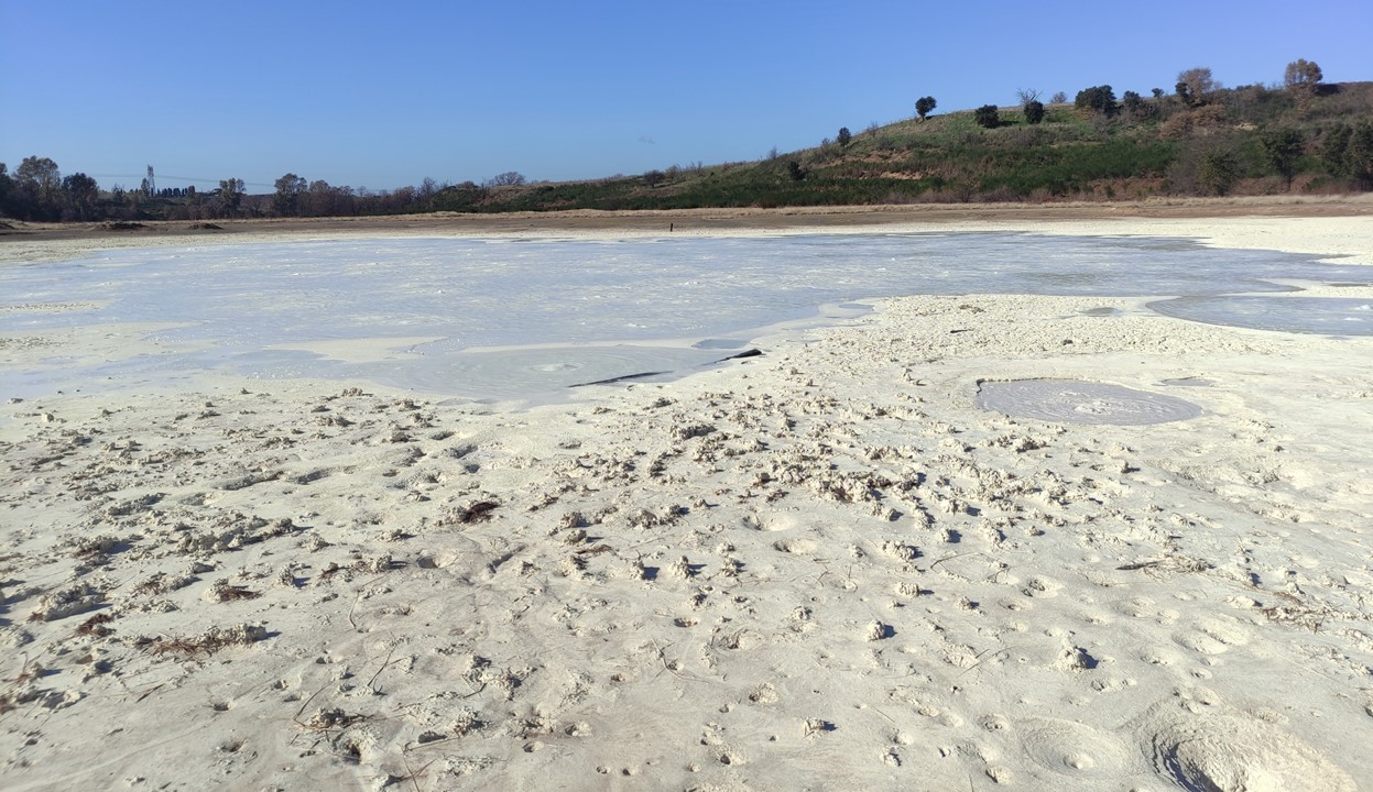
Laura Tenelanda-Osorio, Maëva Millan, Pablo Aguilera, and Maria Isabel Marín-Cerón

1. Introduction
The search for traces of life and biomarkers is one of the main goals of the space exploration towards Mars and the ocean worlds. In this quest, terrestrial
analogues are being used in support of space exploration due to their similarities with the environmental conditions and mineralogies of the planetary bodies targeted by space missions. Specifically, terrestrial analogues serve to guide, prepare, and optimize the flight instruments and the analytical protocols as well as help interpret the in situ data obtained by flight instruments. On Earth, many environments have been identified as targets for planetary sciences and astrobiology because of their extant life and diverse microbial diversity, but also for their capability to preserve biomarkers. Mineral deposits from geothermal hot spring environments constitute one of these interesting targets due to the preservation of textural and organic biomarkers (e.g., lipids) [1, 2, 3]. One of these potential environments is located in the vicinity of the Doña Juana Volcanic Complex (DJVC) in Southwest Colombia. This region hosts numerous hot springs with diverse fluid compositions, geothermal pool temperatures, pHs, and a variety of mineral deposits. These deposits are potential strong repositories of biomarkers, yet only so little is known about their mineralogy, geobiochemistry, or their potential for organic biomarkers preservation.

2. Objective
This study aims to explore the geothermal hot springs near the DJVC to perform a comprehensive biogeochemical study of the hot spring mineral deposits and waters of the geothermal sites of the DJVC in order to enhance our understanding of their mineralogy, geobiochemistry, and their capability to preserve biomarkers and evaluate their potential as planetary analogues. To do so, liquid and solid samples were collected in the geothermal systems of Las Animas and Tajumbina [4].

3. Sample sites and preliminary analyses
The hydrogeochemical analyses that have been performed on the hot springs of the DJVC have allowed to highlight the variety of geothermal pools
present with temperatures ranging from 24 to 69 °C, pH values between 5.75 and 6.7, and an estimation of deep geothermal reservoir temperature over 180 °C [4]. The thermal waters at DJVC also present a variability of water chemistry, and have been divided into two groups: the calcium sulphate-bicarbonate
waters of the Doña Juana System (DJS) and the sodium-chloride waters of the Animas System (AS) [4]. Because of the complex mineral assemblages
within the geothermal pools of DJVC, the DJVC deposits represent a great potential terrestrial analog of the martian deposits that are currently being
explored and collected by the Perseverance rover. The future Rosalind Franklin rover of the Exomars 2028 mission is also aiming to expand the sampling
on Mars, making the study of DJVC deposits more relevant.

4. Laboratory experiments
The samples collected are being characterized using multiple analytical techniques, including techniques that are relevant for the current and future exploration of Mars. The textures, mineralogy, and organic chemistry of the potential Mars analogue features will be characterized using Scanning
Electron Microscopy (SEM), Raman spectroscopy, and X-Ray Diffraction analysis, FTIR. Elemental analysis-isotope ratios mass spectrometry (EA-IRMS)
will also be performed in order to determine the Total Organic Content (TOC) of the samples. Further organic geochemistry experiments will include solid-
liquid extractions as well as flight-like experiments including pyrolysis-GC/MS and wet chemistry techniques relevant for current and future flight-
missions. These experiments will allow to evaluate the biosignatures from the microorganisms thriving in the pools and colonizing the mineral deposits and
to evaluate their preservation potential for biosignatures from extinct forms of life.


Figure 1. Context photos of the sampling sites. Top left: Las Animas, Top right and bottom: Termales de Tajumbina.

Acknowledgements
Support for this research was provided by the ANR LIBIOPANE project, grant ANR-23-CE49-0001 of the French National Research Agency, ANR (Agence
Nationale de la Recherche). The authors acknowledge the municiplity of La Cruz, Nariño, the staff of Termales de Tajumbina and we also thank the
rangers of Parque Nacional Natural Complejo Volcánico Doña Juana- Cascabel for their guidance in the field and their support in the collection of the
samples.

References
[1] McMahon et al. (2018), JGR Planets, 123
[2] William A. (2019) Astrobio. 19, 1-26.
[3] Teece et al., (2023) Astrobio. vol. 23, 2, p. 155-171.
[4] Diaz, E. & Marín-Cerón, M.I. (2020), Geothermics, 4, 101738.

How to cite: Tenelanda-Osorio, L., Millan, M., Aguilera, P., and Marín-Cerón, M. I.: Evaluating the potential of the hydrothermal sites from the Doña Juana Volcanic Complex as Planetary analogues, Europlanet Science Congress 2024, Berlin, Germany, 8–13 Sep 2024, EPSC2024-1303, https://doi.org/10.5194/epsc2024-1303, 2024.