
Mesoscale Modelling of Titan’s Shangri-La region
- 1Sorbonne Université, LATMOS, Paris, France (maxence.lefevre@latmos.ipsl.fr)
- 2Sorbonne Université, LMD, Paris, France
1. Introduction
Titan’s weather is particularly active at all spatial scales: global (e.g., super-rotating winds), intermediate / mesoscale (e.g., convective thunderstorms, air-sea circulations), local (e.g., turbulence in the planetary boundary layer, the atmospheric layer in direct contact with the surface). The aeolian environment of Titan is active, with a fifth of Titan’s surface being covered by dunes fields and the organic dust particles at the surface being potentially transported by wind circulations at all scales.
In 2034 NASA’s Dragonfly quadcopter will land and explore Selk impact crater structure in the dark Shangri-La region [1]. This area is characterized by a surface rich in organic dust particles organized as dune fields, whose peculiar morphology probably involves two distinct wind regimes that remain to be understood [2].
2. Model
To study the near-surface dynamics, a new model was developed based on the Weather-Research Forecast (WRF) non-hydrostatic dynamical core [3] and coupled with the LMD Titan PCM physics package [4]. The domain of interest is centered on Selk crater and Shangri-La region. The horizontal resolution is set to 5 km. High-resolution topography and surface characteristic such as albedo, thermal inertia and surface roughness, were created based on Cassini SAR images. The detail of these synthetic maps are described in detail in the poster presented in this session by Bonnefoy et al. The meteorological fields initial states are taken from LMD Titan PCM outputs. The mesoscale boundary conditions are forced with the LMD Titan GCM.
3. Results
Fig 1 shows Snapshots map of horizontal winds 10 m above local surface (m/s) at noon. The topography, plains and mountains, affects the direction of the surface winds. The vast majority of the wind is between ± 0.5 m/s, consistent with observations. The high mountains are able to engender mountain waves, with horizontal wind reaching 1.0 m/s. The diurnal cycle has an impact on the amplitude and direction of wind, with preferably anabatic winds during the day and katabatic winds at night. The albedo, thermal inertia and surface roughness are set constant respectively to 0.2, 335 J K−1 m−3 and 5 cm. The impact of the spatial variability due to terrain type of these parameters on the winds will be discussed.
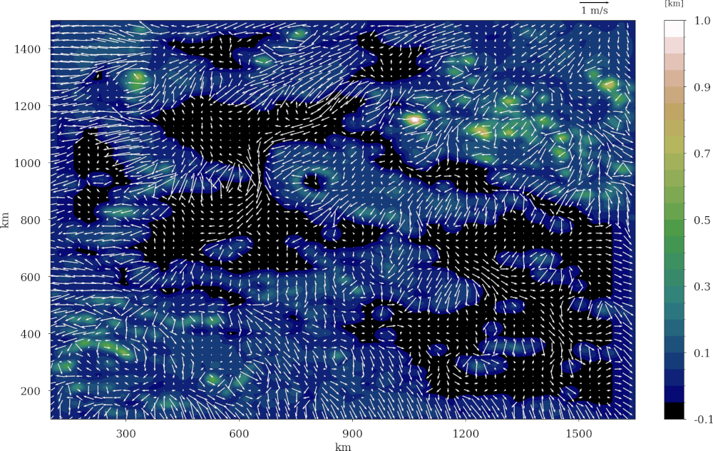
Figure 1: Snapshots map of horizontal winds 10 m above local surface (m s−1 ) at noon in the center of the domain. The red circle represent the landing site of Dragonfly [1].
References
[1] Lorenz, R. D. et al. Selection and Characteristics of the Dragonfly Landing Site near Selk Crater, Titan. Planet. Sci. J. 2, 24 (2021).
[2] Malaska, M. J. et al. Geomorphological map of the Afekan Crater region, Titan: Terrain relationships in the equatorial and mid-latitude regions. Icarus 270, 130–161 (2016).
[3] Skamarock, W. C. & Klemp, J. B. A time-split nonhydrostatic atmospheric model for weather research and forecasting applications. Journal of Computational Physics 227, 3465–3485 (2008).
[4] Lebonnois, S., Burgalat, J., Rannou, P. & Charnay, B. Titan global climate model: A new 3-dimensional version of the IPSL Titan GCM. Icarus 218, 707–722 (2012).
How to cite: Lefevre, M., Bonnefoy, L., and spiga, A.: Mesoscale Modelling of Titan’s Shangri-La region, Europlanet Science Congress 2024, Berlin, Germany, 8–13 Sep 2024, EPSC2024-408, https://doi.org/10.5194/epsc2024-408, 2024.