
Characterization of geological settings related to intrusive magmatism on the Moon and Mars
- Constructor University, Physics & Earth Sciences, Bremen, Germany (jsuarezvalencia@constructor.university)
1. Introduction
The efforts to explore the surfaces of the Moon and Mars are ramping up. Future missions contemplate the construction of permanent base camps [1], which would require a solid knowledge of the terrain and plenty of resources. Understanding the geology of these bodies is of primary importance for this purpose, as well as the identification of potential resource deposits [2]. In this context, medium-scale features gain a bigger relevance, being intrusive domes one of the less investigated [3,4]. Intrusive domes are worth studying, since the geological processes acting over them, and their association with other features like pits and dykes are appealing for space exploration [5].
This abstract showcases the work done in a doctoral research, where we studied two locations: The Valentines domes on the Moon (30.69 N, 10.20 E), and the domes in west Utopia Planitia on in Mars (centred 41°N, and 77°E).
2. Data and Methods
For the Moon, we used a global WAC mosaic, and 23 NAC images from the Lunar Reconnaissance Orbiter [6]. Two DEMs, a global LRO-Kaguya mosaic; and a DEM derived from NAC stereo pairs. We also derived 28 spectral indexes from the Moon Mineralogy Mapper [7]. For Mars, we used the global CTX mosaic, 42 HiRISE images, and 8 CRISM cubes form the Mars reconnaissance Orbiter [8].
To analyse the geological settings of the two locations we used a hybrid mapping approach, incorporating geomorphological and spectral information in a single product [9]. We first created geomorphological units, which were later refined or modified according to the spectral information. We also computed the age of the units using the crater size-frequency counting technique. The analysis and mapping were done in the geoprocessing software QGIS with the aid of Mappy [10].
3. Results and discussion
3.1 MoonIndex
While working with the hyperspectral data of the Moon we noticed the lack of an open-source tool to generate spectral indexes from it, since these are important products to survey the mineralogy of a planetary surface, we developed a Python library called MoonIndex, which recreated 38 indexes from the literature. The workflow of the library can be seen in Figure 1, the processing started with the filtering of the data, followed by the removal of the continuum. The indexes were then calculated following as possible the original formulations. Our results were consistent with the ones in the literature, so they were suitable for interpretation.
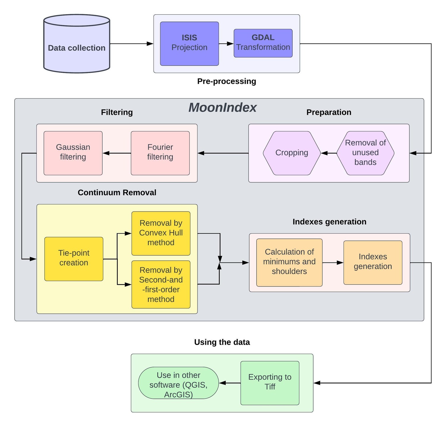
Figure 1: Flow-chart of the full procedure of MoonIndex.
3.2 Valentine Domes
After developing MoonIndex, we proceeded with the geostratigraphic mapping of the Valentine Domes (Figure 2). The intrusive domes are oval-shaped structures with low altitude, small slope, and dissected by fractures and faults. We defined three main domes (Ev2, Ev2, Ev3), they have several secondary structures on top of them. These structures were originally classified as kipukas by [3], but a spectral analysis showed that most of them are smaller intrusive domes.
The emplacement of the large domes is related to the intrusion of a large igneous complex below the area, and occurred after 2.8 Ga and before 1.81 Ga. The secondary domes likely formed after 1.81 Ga by intruding dykes. All of this suggest that this system was big and active for several million years, the intrusive rocks might even outcrop thanks to the complex systems of fractures that crosses the domes, which is an opportunity to reach potential resources.
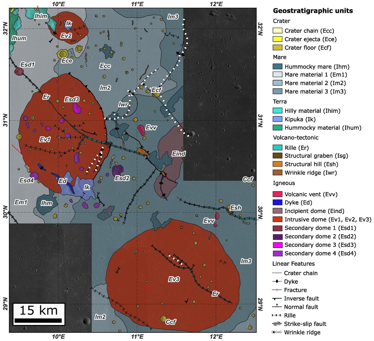
Figure 2: Detailed geostratigraphic map of the Valentine Domes.
3.3 Western Utopia Planitia
This flat region is in the west margin of Utopia Planitia, across the plain are scattered hundreds of monogenetic domes. Due to the large size of the zone, and the small size of the features, our approach consisted of doing a regional mapping of the zone and the detailed mapping of representative domes. Most of the domes are oval-shaped, but others are elongated or have lobes attached to their main body. Most of the domes have an outer crust, which was interpreted by [4] as a mixture of hyaloclastite and periglacial deposits. The domes are likely the product of individual intrusions of a large igneous system beneath the zone, some of them intruded at shallow depths, allowing the formation of the hyaloclastite crust, while others even reached the surface, due to the presence of volcanic craters and lobes. This system is similar to the dome field in Arcadia Planitia [11], both representing a complex system of intrusive-to-extrusive activity.
4. Conclusions
Intrusive domes are uncommon and complex systems in the Moon and Mars, they are usually related with big igneous systems in the subsurface, intensive fracturing, and a mineralogy that contrast with their surroundings, making them interesting location for future exploration.
The hundreds of domes in Utopia Planitia contrast with the three Valentine domes in the Moon, indicating a difference in how these processes occurs in both bodies. Several intrusive domes remain to be discovered and studied, and more research is needed to further characterize their formation and potential use in future missions.
Acknowledgements
This project has received funding from the European Union’s Horizon 2020 research and innovation programme under grant agreement No 101004214.
References
[1] NASA. (2020). NASA’s Lunar Exploration Program Overview.
[2] Lewis et al. (1993). Using resources from neart-earth space.
[3] Wöhler & Lena (2009). Lunar intrusive domes: Morphometric analysis and laccolith modelling.
[4] Farrand et al. (2021). Spectral and geological analyses of domes in western Arcadia Planitia, Mars: Evidence for intrusive alkali-rich volcanism and ice-associated surface features.
[5] Braden & Robinson (2011). Human exploration of the Gruithuisen Domes.
[6] Robinson et al. (2010). Lunar Reconnaissance Orbiter Camera (LROC) Instrument Overview.
[7] Green et al. (2011). The Moon Mineralogy Mapper (M 3 ) imaging spectrometer for lunar science: Instrument description, calibration, on-orbit measurements, science data calibration and on-orbit validation.
[8] Zurek & Smrekar (2007). An overview of the Mars Reconnaissance Orbiter (MRO) science mission.
[9] Aileen Yingst et al. (2023). A Geologic Map of Vesta Produced Using a Hybrid Method for Incorporating Spectroscopic and Morphologic Data.
[10] Penasa, L., & Brandt, C. H. (2021). [Software].
[11] Rampey et al. (2007). Identity and emplacement of domical structures in the western Arcadia Planitia, Mars.
How to cite: Suarez Valencia, J. E. and Rossi, A. P.: Characterization of geological settings related to intrusive magmatism on the Moon and Mars, Europlanet Science Congress 2024, Berlin, Germany, 8–13 Sep 2024, EPSC2024-466, https://doi.org/10.5194/epsc2024-466, 2024.