TP7 | Planetary volcanism, tectonics, and seismicity

TP7

Planetary volcanism, tectonics, and seismicity
Co-organized by MITM
Conveners: Petr Broz, Oguzcan Karagoz, Iris van Zelst | Co-conveners: Ernst Hauber, Chloe Michaut, Sam Poppe, Filippo Carboni, Carolyn van der Bogert, Evandro Balbi, Gene Schmidt, Paola Cianfarra, Anna Horleston, Naomi Murdoch, Maxence Lefevre
Orals
| Wed, 11 Sep, 16:30–18:00 (CEST)|Room Uranus (Hörsaal C)
Posters
| Attendance Wed, 11 Sep, 10:30–12:00 (CEST) | Display Wed, 11 Sep, 08:30–19:00
Orals |
Wed, 16:30
Wed, 10:30
Volcanism and tectonics are two of the most ubiquitous processes at work in the Solar System, substantially shaping the diverse surfaces of terrestrial planets, moons, and icy satellites. High-resolution orbital data, samples from the lunar surface, and seismic data from the Moon and Mars, have provided important constraints on the evolution of planetary bodies and their tectonic regimes. This gives us a much better understanding of how these worlds evolved, how they are internally structured, and why their surfaces look the way they do. Following the success of InSight on Mars, the selection of e.g., Dragonfly, VERITAS, EnVision, Chang’e 6 and the Farside Seismic Suite promise a wealth of additional observations of Titan, Venus, and the Moon that will contribute to furthering knowledge not only of the extent of volcanic and tectonic activity on these worlds, but also of their seismicity. Small body seismology is also becoming a hot topic, with space agencies considering seismometers for inclusion in future missions to asteroids and comets.

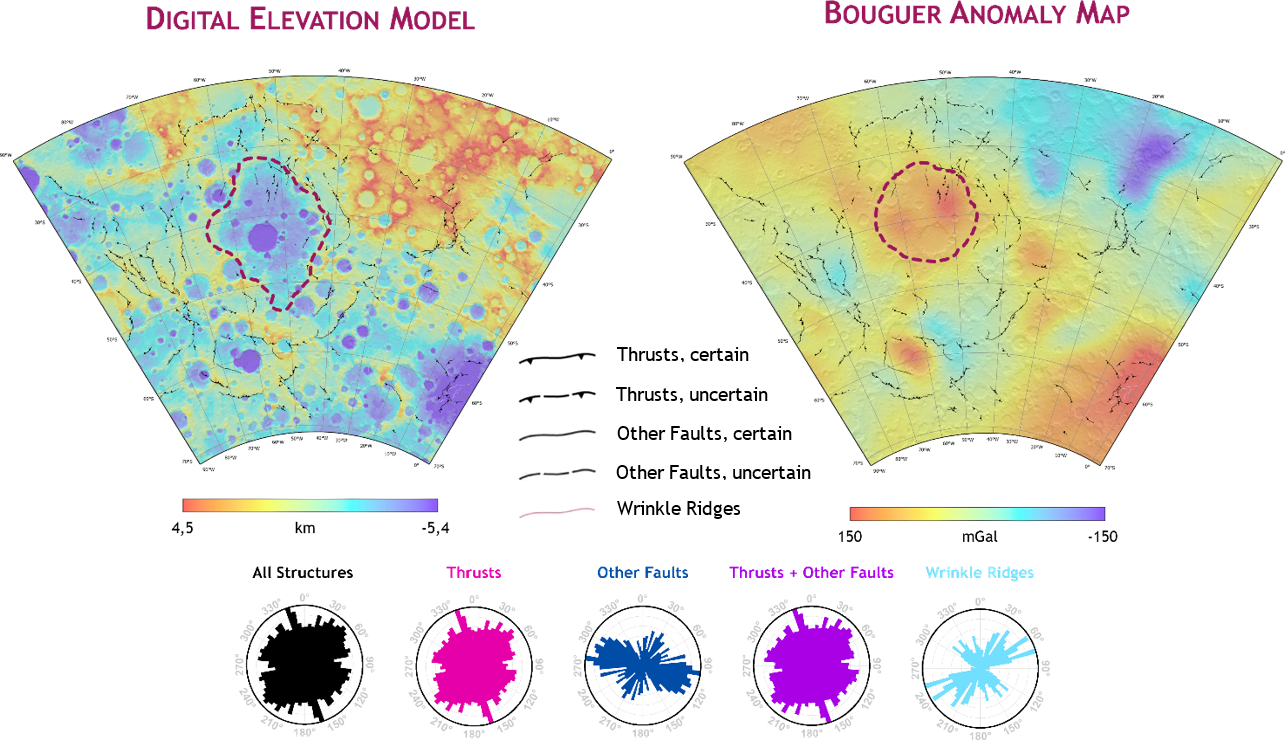
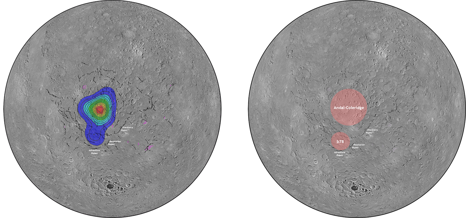
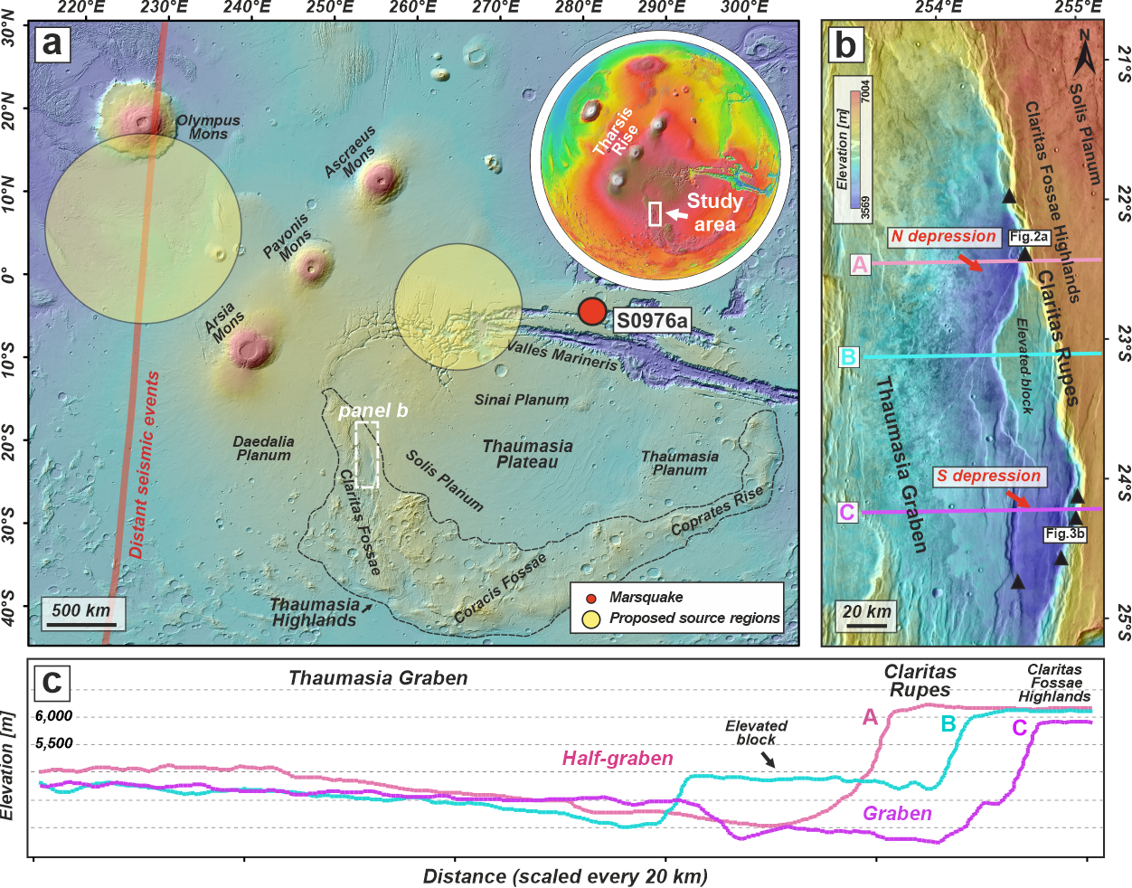
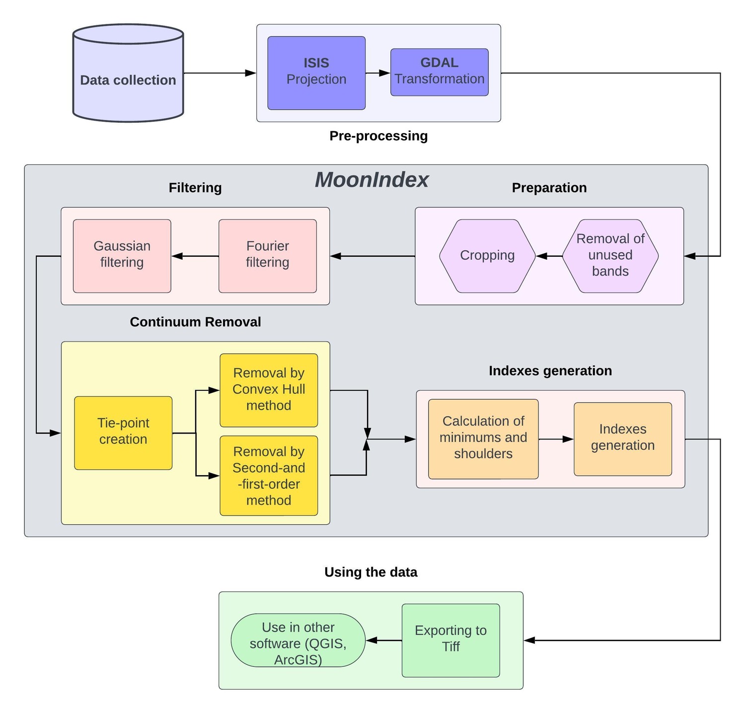
This session invites observational, analytical, theoretical, and analogue fieldwork research into any aspect of planetary endogenic processes. We welcome submissions on comparing landforms and processes on multiple bodies; geochemical and chronological data from planetary material; numerical modeling studies; tectonics and seismicity across the Solar System; theoretical and technical designs for current or future missions; as well as data analysis and insights on the seismicity and interior structures of planets and small bodies.

Orals: Wed, 11 Sep | Room Uranus (Hörsaal C)

Chairpersons: Petr Broz, Oguzcan Karagoz, Iris van Zelst
16:30–16:40
|
EPSC2024-39
|
ECP
|
On-site presentation
Bartosz Pieterek, Petr Brož, and Ernst Hauber

Introduction

Current seismic events detected by NASA’s InSight mission suggest that Mars is still seismically and/or tectonically active. Most of the Marsquakes are associated with the Cerberus Fossae region[1,2,3], but the locations of other seismically active centers are poorly constrained [4]. Specifically, recent endogenic activity within Tharsis is poorly constrained although Tharsis-related stresses induced by Late Amazonian volcanic loading[5,6] have likely accumulated within the Martian crust and should lead to recent tectonic activity within this region. To date, only very few morphologically pristine tectonic structures in Tharsis have been documented. Therefore, we followed up on our previous study [7] of the Claritas Fossae region and searched for evidence of recent tectonic structures.

Figure 1 (a) Schematic map of the Tharsis including Thaumasia and Claritas Fossae, our region of interest. Marked by yellow-shaded circles are the positions of proposed source regions of seismic activity of the distant events interpreted for Tharsis [1]. (b) A topographic image of the studied region, the black triangles indicate the locations of investigated fresh-looking scarps. (c) The corresponding topographic profiles of the study region. Produced using the MOLA MEX – HRSC global blended digital elevation model [8].

Observations

The topography of the Claritas Fossae region is dominated by the N020W-trending steep scarp of Claritas Rupes. This scarp, locally exceeding 2,000 meters in height, has been likely formed during the last stage of the main phase of Thaumasia tectonics in the Late Hesperian or Early Amazonian [9]. It was interpreted as the surface expression of a crustal-scale listric normal fault that to the formation of the present regional half-graben morphology [10]. Using the Context Camera (CTX) (5–6 m/px) and High Resolution Imaging Science Experiment (HiRISE) images (25–50 cm/pixel), we identified fresh-appearing scarps with lengths of typically less than one kilometer. Detailed inspection of the scarps reveals uphill-facing (antislope) and pristine morphologies, without evidence of significant modification by erosion or coverage by aeolian deposits. Based on a CTX-based Digital Elevation Model (DEM), we found that the western shoulders of the scarps rise above the inferred average slope of the main scarp, and this topographical offset stops the downslope movement of boulders released from the main Claritas Rupes scarp, leading to their accumulation along the scarps. In some places, where these scarps are not present or less well developed, the boulders were capable of moving further downslope.

Figure 2 (a-b) Examples of identified uphill-facing scarps that stopped and accumulated downslope moving boulders (ESP_078218_1575). (c) Slope map and corresponding CTX-based topographic profile showing that the western shoulders of the scarps rise above the inferred average slope of the main scarp. CTX stereo-pair (P18_007945_1532 and N10_066414_1533) (d) Close-up image of the boulders and their tracks that have been stopped at the antislope scarp (PSP_007945_1555). (e) Schematic drawing presenting the relationship between the uphill-facing scarps and downslope moving boulders (ESP_078508_1555). The north is up.

Discussion and conclusion

The formation of terrestrial uphill-facing scarps is often attributed to Deep-seated Gravitational Spreading Deformations (DGSDs), or instabilities related to glacial retreat. As the studied area does not show any signs of past glaciation(s), neither glacial-induced DGSDs nor post-glacial uplift can readily explain the scarp formation. Uphill-facing scarps could represent antithetic normal faults formed simultaneously or after the formation of the main crustal-scale fault of Claritas Rupes in the Late Hesperian/Early Amazonian [11]. However, this scenario is unlikely due to the pristine morphology of the identified scarps, which argues against such age. Furthermore, their formation could be related to slope gravitational processes such as rotational sliding but we do not find any evidence of the formation of morphologically similar scarps on the other similar-size scarps elsewhere in Tharsis. Nevertheless, the formation of DGSDs can be triggered by the presence of tectonic discontinuities in seismically active regions. Thus, in the context of the long-lived and complex tectonic evolution of the Claritas Fossae region, we infer that that scenario is plausible.

The pristine appearance of the identified scarps suggests that Claritas Fossae might be tectonically inactive. As the determination of absolute (model) ages of small-scale linear tectonic features is almost impossible, we used relative dating. The observed boulders tracks indicate continuous and intense mass wasting processes at the Claritas Rupes scarp that should quickly fill the accommodation space created by the uphill-facing scarps. As a consequence, these small uphill-facing scarps would be covered and precluded from possible identification. Moreover, the pristine appearance of the faults, as visible in image observations and topographic profiles, suggests that the tectonic activity responsible for the fault formation is so young that slope movements and aeolian processes have not yet erased their evidence.

Acknowledgments: BP was financially supported by the Ministry of Education and Science, Poland, with publication grant funding (62.9012.2401.00.0).

References:

[1] Ceylan, S. et al. J. Geophys. Res. Planets 128 (8), e2023JE007826 (2023);[2] Rivas-Dorado, S. et al. Earth Planet. Sci. Lett. 594, 117692 (2022); [3] Horvath, D. G. et al. Icarus 365, 114499 (2021); [4] Stähler, S. C. et al. in 55th Lunar and Planetary Science Conference 2641 (2024); [5] Pieterek, B. et al. Icarus 386, 115151 (2022);[6] Hauber, E. et al. Geophys. Res. Lett. 38, 1–5 (2011); [7] Pieterek, B. et al. 407, 115770 (2024); [8] Balbi, E. et al. Icarus 115972 (2024); [9] Fergason, R. L. et al. US Geol. Surv. (2018) [10] Hauber, E. et al. J. Geophys. Res. Planets 110, 1–13 (2005); [11] Tanaka, K. L. et al. J. Geophys. Res. 93, 893–917 (1988)

How to cite: Pieterek, B., Brož, P., and Hauber, E.: Neotectonic activity at the Claritas Rupes scarp, Thaumasia region, Mars, Europlanet Science Congress 2024, Berlin, Germany, 8–13 Sep 2024, EPSC2024-39, https://doi.org/10.5194/epsc2024-39, 2024.

16:40–16:50
|
EPSC2024-466
|
ECP
|
On-site presentation
Javier Eduardo Suarez Valencia and Angelo Pio Rossi

1. Introduction

The efforts to explore the surfaces of the Moon and Mars are ramping up. Future missions contemplate the construction of permanent base camps [1], which would require a solid knowledge of the terrain and plenty of resources. Understanding the geology of these bodies is of primary importance for this purpose, as well as the identification of potential resource deposits [2]. In this context, medium-scale features gain a bigger relevance, being intrusive domes one of the less investigated [3,4]. Intrusive domes are worth studying, since the geological processes acting over them, and their association with other features like pits and dykes are appealing for space exploration [5].

This abstract showcases the work done in a doctoral research, where we studied two locations: The Valentines domes on the Moon (30.69 N, 10.20 E), and the domes in west Utopia Planitia on in Mars (centred 41°N, and 77°E).

2. Data and Methods

For the Moon, we used a global WAC mosaic, and 23 NAC images from the Lunar Reconnaissance Orbiter [6]. Two DEMs, a global LRO-Kaguya mosaic; and a DEM derived from NAC stereo pairs. We also derived 28 spectral indexes from the Moon Mineralogy Mapper [7]. For Mars, we used the global CTX mosaic, 42 HiRISE images, and 8 CRISM cubes form the Mars reconnaissance Orbiter [8].

To analyse the geological settings of the two locations we used a hybrid mapping approach, incorporating geomorphological and spectral information in a single product [9]. We first created geomorphological units, which were later refined or modified according to the spectral information. We also computed the age of the units using the crater size-frequency counting technique. The analysis and mapping were done in the geoprocessing software QGIS with the aid of Mappy [10].

3. Results and discussion

3.1 MoonIndex

While working with the hyperspectral data of the Moon we noticed the lack of an open-source tool to generate spectral indexes from it, since these are important products to survey the mineralogy of a planetary surface, we developed a Python library called MoonIndex, which recreated 38 indexes from the literature. The workflow of the library can be seen in Figure 1, the processing started with the filtering of the data, followed by the removal of the continuum. The indexes were then calculated following as possible the original formulations. Our results were consistent with the ones in the literature, so they were suitable for interpretation.

Figure 1: Flow-chart of the full procedure of MoonIndex.

3.2 Valentine Domes

After developing MoonIndex, we proceeded with the geostratigraphic mapping of the Valentine Domes (Figure 2). The intrusive domes are oval-shaped structures with low altitude, small slope, and dissected by fractures and faults. We defined three main domes (Ev2, Ev2, Ev3), they have several secondary structures on top of them. These structures were originally classified as kipukas by [3], but a spectral analysis showed that most of them are smaller intrusive domes.

The emplacement of the large domes is related to the intrusion of a large igneous complex below the area, and occurred after 2.8 Ga and before 1.81 Ga. The secondary domes likely formed after 1.81 Ga by intruding dykes. All of this suggest that this system was big and active for several million years, the intrusive rocks might even outcrop thanks to the complex systems of fractures that crosses the domes, which is an opportunity to reach potential resources.

Figure 2: Detailed geostratigraphic map of the Valentine Domes.

3.3 Western Utopia Planitia

This flat region is in the west margin of Utopia Planitia, across the plain are scattered hundreds of monogenetic domes. Due to the large size of the zone, and the small size of the features, our approach consisted of doing a regional mapping of the zone and the detailed mapping of representative domes. Most of the domes are oval-shaped, but others are elongated or have lobes attached to their main body. Most of the domes have an outer crust, which was interpreted by [4] as a mixture of hyaloclastite and periglacial deposits. The domes are likely the product of individual intrusions of a large igneous system beneath the zone, some of them intruded at shallow depths, allowing the formation of the hyaloclastite crust, while others even reached the surface, due to the presence of volcanic craters and lobes. This system is similar to the dome field in Arcadia Planitia [11], both representing a complex system of intrusive-to-extrusive activity.      

4. Conclusions

Intrusive domes are uncommon and complex systems in the Moon and Mars, they are usually related with big igneous systems in the subsurface, intensive fracturing, and a mineralogy that contrast with their surroundings, making them interesting location for future exploration.

The hundreds of domes in Utopia Planitia contrast with the three Valentine domes in the Moon, indicating a difference in how these processes occurs in both bodies. Several intrusive domes remain to be discovered and studied, and more research is needed to further characterize their formation and potential use in future missions. 

Acknowledgements

This project has received funding from the European Union’s Horizon 2020 research and innovation programme under grant agreement No 101004214.

References

[1] NASA. (2020). NASA’s Lunar Exploration Program Overview.

[2] Lewis et al. (1993). Using resources from neart-earth space.

[3] Wöhler & Lena (2009). Lunar intrusive domes: Morphometric analysis and laccolith modelling.

[4] Farrand et al. (2021). Spectral and geological analyses of domes in western Arcadia Planitia, Mars: Evidence for intrusive alkali-rich volcanism and ice-associated surface features.

[5] Braden & Robinson (2011). Human exploration of the Gruithuisen Domes.

[6] Robinson et al. (2010). Lunar Reconnaissance Orbiter Camera (LROC) Instrument Overview.

[7] Green et al. (2011). The Moon Mineralogy Mapper (M 3 ) imaging spectrometer for lunar science: Instrument description, calibration, on-orbit measurements, science data calibration and on-orbit validation.

[8] Zurek & Smrekar (2007). An overview of the Mars Reconnaissance Orbiter (MRO) science mission.

[9] Aileen Yingst et al. (2023). A Geologic Map of Vesta Produced Using a Hybrid Method for Incorporating Spectroscopic and Morphologic Data.

[10] Penasa, L., & Brandt, C. H. (2021). [Software].

[11] Rampey et al. (2007). Identity and emplacement of domical structures in the western Arcadia Planitia, Mars.

How to cite: Suarez Valencia, J. E. and Rossi, A. P.: Characterization of geological settings related to intrusive magmatism on the Moon and Mars, Europlanet Science Congress 2024, Berlin, Germany, 8–13 Sep 2024, EPSC2024-466, https://doi.org/10.5194/epsc2024-466, 2024.

16:50–17:00
|
EPSC2024-1273
|
On-site presentation
Bastien Bodin, Daniel Cordier, and Ashley Davies

Planetary volcanism is a widespread phenomenon throughout the Solar System (Lopes et al., 2010). Volcanism can be classified into two categories: silicate-based volcanism, which occurs on telluric planets, and cryovolcanism, which may occur on several outer Solar System bodies (e.g., Geissler, 2015). Cryovolcanism is assumed to play a significant role in shaping the surfaces of many icy worlds. Evidence of cryovolcanic activity has been detected on Pluto (Singer et al., 2022) and Enceladus (Hansen et al., 2006); it is also suspected of being present on Europa (Fagents, 2003; Sparks et al., 2017) and Titan (Lopes et al., 2013).

Modeling cryovolcanism is crucial for understanding the geological processes shaping the complex surface of Europa. In addition, investigating the resurfacing processes on this moon can improve our insight into subsurface chemophysical properties and prebiotic potential.

Several numerical models of Europa cryovolcanism are already available in the literature, concerning either the possible eruption mechanisms (Lesage, Massol, and Schmidt, 2020) or the subsequent lava flow (Morrison, Whittington, and Mitchell, 2023). According to the scenario we have adopted, liquid water ascending to the surface through the volcanic conduit is significantly depressurized, resulting in a relatively dense mixture of vapor and small ice crystals, similar to terrestrial fluidized snow. This type of fluid has been recognized as having Bingham-like rheology (Maeno and Nishimura, 1979). We then developed a two-dimensional numerical model of the dynamics of such a fluid. We adopted a Smoothed-Particle Hydrodynamics (SPH) method (Gingold and Monaghan, 1977; Lucy, 1977), which is particularly relevant for systems with free surfaces. This makes SPH particularly relevant in the context of lava flow simulations (Prakash and Cleary, 2011; Bilotta et al., 2016).

Focusing on the formation of so-called smooth plains, we have simulated the dynamics of possible effusive eruptions at the surface of Europa. In particular, we assess the influence of parameters governing the thermodynamic and rheological properties of the considered fluid.

How to cite: Bodin, B., Cordier, D., and Davies, A.: 2D Dynamics of a lava flow on Europa, Europlanet Science Congress 2024, Berlin, Germany, 8–13 Sep 2024, EPSC2024-1273, https://doi.org/10.5194/epsc2024-1273, 2024.

17:00–17:10
|
EPSC2024-1339
|
On-site presentation
Barbara De Toffoli, Ana-Catalina Plesa, Francesco Mazzarini, Richard Ghail, and Doris Breuer

Introduction

Venus represents a terrestrial planet similar to Earth in size and mass, but its evolution is characterized by a lack of plate tectonics as observed on Earth. On Venus a rich variety of tectono-magmatic structures were detected. In this context, major zones of young extensional structures, called chasmata, are present on the Venus surface (e.g., Ivanov and Head, 2011). The origin of these rift systems is still debated. Suggested hypotheses include diapiric upwelling (Stofan et al., 1992) and lithospheric extension over the heated mantle (Phillips and Hansen, 1998; Hansen and Phillips, 1993).

Parga Chasma is a discontinuous rift system extending for 10,000 km from Atla Regio to Themis Regio (Chapman and Kirk, 1996). On Earth, large-scale rifting is usually associated with plume centers, or igneous provinces, with faulting and fracturing spreading around volcano-magmatic centers forming triple-junction rifting. Comparable features in the Parga region are magmatic centers constituted by coronae or large volcanoes (Graff et al., 2018). Coronae are circular to elongated features surrounded by concentric fractures that reach diameters of hundreds of kilometers (Basilevsky & Head, 2003) and are mostly located along rifts (Stofan et al., 1997). Coronae are likely the result of the mantle plumes’ rise and collapse that generates typical radiating volcanic flows and concentric annular structures (Basilevsky & Head, 2003). These features can be found in large numbers making them an outstanding tool for the lithosphere thickness investigation (Johnson and Solomon 1996).

Methods

We collected existing datasets of mapped coronae produced using Magellan SAR data sets (Gazetteer of Planetary Nomenclature USGS-NASA; Martin et al., 2007; Stofan et al., 2001). For the investigation of the regional-scale evolution of the study area, coronae included in the analyses needed to be on the rift or in a 1,500 km range distance (Martin et al., 2007; Hamilton and Stofan, 1996). As a result, the analyzed population was of 141 coronae identified in QGIS software as point-shaped features localized at the center of coronae’s anuli. Accordingly, all analyses were performed on datasets extracted through QGIS software tools for distance and Nearest Neighbor determination obtained by handling the point shapefile identifying coronae locations.

In cases where a substantial number of features are surveyed on large areas, like Parga, point clustering can be conducted using MINITAB® software and an agglomerative hierarchical clustering method (Mazzarini, 2007). Clustering provides a statistically significant subdivision of the original population allowing further analyses to explore the possibility of having multiple reservoirs feeding the vents of interest.


The presence of numerous volcanic features suggests the existence of subcrustal/crustal magma reservoirs formed by magmatic upwelling. The Rayleigh Taylor (R-T) gravitational instability theory, applied to Venusian coronae, establishes a relationship between the spacing of volcanic structures at the surface and the depth of underlying magmatic reservoirs. This theory describes the upwelling of less dense material when overlain by denser layers, leading to gravitational instability and vertical spread of material. Depending on melt viscosity, instabilities may develop, resulting in upwelling and penetration of less dense material into the overlying fluid at evenly spaced points (Whitehead et al., 1984; Tackley et al., 1992). This approach, previously applied to volcanic clusters on Earth, including the Newer Volcanic Province in Southern Australia (Lesti et al., 2007) and the Main Ethiopian Rift (Mazzarini et al., 2013), is employed to identify the depth of thermal anomalies acting as magma source regions beneath Venusian coronae. The investigation utilizes a sinusoidal projection centered on the Parga region to minimize spatial distortion, with the average separation between coronae implemented in the R-T gravitational instability function to estimate the anomaly's wavelength and depth.

In order to investigate the depth of magmatic reservoirs we also performed thermal evolution modeling. To this end we used the geodynamic code GAIA (Hüttig et al., 2013) in a 2D spherical annulus geometry (Fleury et al., 2024). Our models include a variable thermal conductivity and thermal expansivity (Tosi et al., 2013) and we test different scenarios varying the magmatic style from fully intrusive to fully extrusive magmatism (Herrera et al., this meeting). In addition, we varied the depth at which melt remains trapped in the subsurface. The depth of the thermal anomaly obtained from the R-T analysis is compared to the depth of melting in our geodynamic models. Additionally, the spacing of volcanic structures observed at the surface is compared to the spacing obtained in our models between small-scale convection structures to select the scenarios that fit best the geological analysis.  


Preliminary Results

Our findings provide insights into the spatial distribution and depths of thermal anomalies beneath Venusian coronae in the Parga region. Cluster analysis unveiled distinct spatial groupings of coronae, with notable polarization observed towards the northwest and southeast ends of the rift. Despite spatial clustering tendencies, the average distances between coronae remained remarkably consistent across the whole population and individual clusters. Utilizing the R-T gravitational instability theory, we estimated depths of thermal anomalies beneath coronae, providing constraints for the underlying magmatic processes. Specifically, we obtained a thermal anomaly depth of 117 ± 10 kilometers for the total population; spanning between 111 kilometers for the northwest cluster and 126 kilometers for the southeast cluster. Moreover, along Parga, an increase of the size of the coronae is observed from the north-west sector toward the southeastern one. Comparing the thermal anomaly depth obtained from the R-T analysis and the spacing between coronae in Parga Chasma with our thermal evolution models we find that best fit scenarios require less than 40% of the melt generated in the interior to reach the surface, indicating that Parga Chasma is dominated by magmatic intrusions.

Implications

In conclusion, our study establishes a direct link between coronae formation and the location of magmatic reservoirs beneath Venus’ surface. By elucidating this relationship, our research sheds light on the dynamic processes shaping the Venusian lithosphere and offers valuable insights into the underlying mechanisms driving its tectonic evolution.

Acknowledgement

This work is funded by the European Union – NextGenerationEU and by the 2023 STARS Grants@Unipd programme – “HECATE project”.

How to cite: De Toffoli, B., Plesa, A.-C., Mazzarini, F., Ghail, R., and Breuer, D.: Unveiling Magma Reservoir Depths Beneath Venusian Coronae: Insights from the Parga Region, Europlanet Science Congress 2024, Berlin, Germany, 8–13 Sep 2024, EPSC2024-1339, https://doi.org/10.5194/epsc2024-1339, 2024.

17:10–17:15
17:15–17:25
|
EPSC2024-383
|
On-site presentation
Thomas Kenkmann and Oguzcan Karagoz

 Abstract

We analyzed the structure of Atahensik Corona (700 x 900 km) of eastern Aphrodite Terra on Venus. This corona contains a high density of radial, oblique, and concentric fractures and is surrounded by arcuate troughs. The high density of concentric fractures along the outer rise indicates elastic down-bending of the corona´s surrounding. The deep, asymmetrical, and arc-shaped troughs are expressions of incipient subduction and expose large-scale fault zones along their steep inner slopes that trend parallel to the trough axes. The exposed faults are several hundred kilometers long and dip gently towards the corona center. The faults have a multi-stage history. They were initiated as thrusts but became reactivated as low-angle normal faults and then exposed parts of their fault surfaces. The multi-stage activation is in agreement with current models of corona formation. Plume uplift and topographic uplift of the corona interior are indicated by early radial fracturing. Subsequent lateral spreading of the plume steepened the outer rim and caused a fractured ridge annulus to form. Overthrusting in the corona periphery may have started in the immediate surrounding of a negatively buoyant, delaminated lithosphere, where the lithosphere was intact and cooler. Reactivation of the thrusts as low-angle normal faults resulted from subsidence of the corona´s interior as a consequence of decreased activity and cooling, and subsequent gravitational instability of the elevated corona annulus.

Introduction

Coronae are unique volcano-tectonic features on Venus that transport heat from the mantle to the surface. Large coronae are roughly circular to ovoid, contain a fractured ridge annulus, and are surrounded by arcuate troughs and outer rises [1-2]. The central regions of coronae may contain volcanic edifices [3]. The majority of geodynamic models of corona formation postulate a buoyant magma diapir that rises through the mantle [3-5] followed by a lateral spreading of the plume. Other models suggest that coronae result from Rayleigh–Taylor instability of the mantle [6] or by magmatic loading of the crust.

Fig.1 Magellan SAR image (left looking) of Atahensik Corona and NW-SE topographic profile across the structure.

Data and Methods

We used NASA´s Magellan synthetic aperture radar (SAR) global mosaics, which have a spatial resolution of ∼75 m per pixel in this region [7], and DEM that is based on a combination of Magellan global topography data records and a stereo imagery cross-correlation of SAR data [8]. For mapping of radar images using ArcGIS 10.7, we have adopted a black-and-white inversion approach for the SAR data. Measurements of strike and dip of faults were carried out with the LayerTools plugin for ArcGIS [9].

Results and Interpretation

Atahensik is one of the largest coronae on Venus (Fig.1). It has an asymmetric, eye-shaped form and comprises several asymmetric and arc-shaped troughs. The convex sides of the troughs are flanked by broad and gentle outer rises. The troughs have asymmetric topographic profiles (Fig.1) with a gentle outer slope and a steep inner slope that merge into the Atahensik´s annulus ridge. The central region of Atahensik Corona is morphologically depressed (Fig.1).

Fig.2 Fractures and major faults of Atahensik. The orientation of fractures relates to Atahensik´s center.

Atahensik Corona has a high density of fractures (Fig.2). A detailed analysis of crosscutting relationships between the fracture systems indicates that radial fractures in most cases developed first, followed by oblique, and finally concentric fractures. The inner slopes of the arcuate troughs show abrupt changes in SAR reflectivity (Fig.3) and major fault traces parallel to the trough axes were detected. Radial fractures do not continue from the convexly shaped hanging wall to the footwall of the faults. The faults strike concentrically and gently dip to the corona center. The smooth fault planes are partly exposed and form terraces in the slope profiles. This can only occur in a normal faulting regime when the hanging wall is displaced and exposes parts of the fault plane. The observation that the faults are low-angle normal faults is in contrast to the trough asymmetry, the presence of an outer rise, and the fracture pattern that all indicate lithospheric bending associated with overthrusting and incipient subduction (Fig.1). The apparent contradiction is resolved when a reactivation of the fault with the opposite shear sense is assumed. We propose that the faults were initially formed as thrusts during incipient subduction with a typical dip of ~30° towards the corona but were reactivated as a low-angle normal faults, thereby exposing their fault planes. A fault reactivation is expected when the horizontal compressive stresses radial to the corona, e.g. by down-welling decrease and the topographically high ridge annuli forming the rim of Atahensik Corona become gravitationally unstable in a phase of declining magmatic activity. The multi-stage activation agrees with the evolutionary sequence proposed for corona formation. Fault reactivation is a well-known phenomenon on Earth and low-angle normal faults are widely recognized [10]. The reactivation of a thrust fault as a low-angle normal fault requires a significantly reduced friction coefficient. On Earth, this is achieved by the presence of ductile shear zones, phyllosilicates, or a fluid overpressure. In the absence of hydrous phases and fluids on Venus, a decrease in fault strength and friction coefficient might be achieved by abrasive smear of rocks associated with thermally activated crystal plasticity or the lubrication of the fault plane by a melt film, possibly of a frictional origin.

Fig.3 Inverted SAR of the SE Atahensik trough with tectonic labels, LayerTool line, and the average dip angle and dip azimuth of the major fault.

References:

[1] Smrekar, S.E., Stofan, E.R., 1997, Science 277, 1289-1294. [2] Sabbeth, L. et al. 2024, EPSL, 633, 118568. [3] Squyres, S.W. et al., 1992, JGR 97, 13611–13634. [4] Gülcher, A.J. et al., 2020, Nature Geoscience, 13(8), 547-554. [5] Hoogenboom, T. & Houseman, G.A., 2006, Icarus, 180, 292-307.  [6] Tucker, W.S. & Dombard, A.J., 2023, JGR, 128, e2023JE007971. [7] Pettengill, G.H., et al., 1991, Science, 252, 260-265. [8] Herrick, R.R. et al. 2012, EOS, 93, 125–126.  [9] Kneissl, T., et al., 2010, LPSC, 41, #1640. [10] Wernicke, B., 1995, JGR 100, 20159-20174.

How to cite: Kenkmann, T. and Karagoz, O.: Low-angle faults at the rim of a large Venusian corona, Europlanet Science Congress 2024, Berlin, Germany, 8–13 Sep 2024, EPSC2024-383, https://doi.org/10.5194/epsc2024-383, 2024.

17:25–17:35
|
EPSC2024-915
|
ECP
|
On-site presentation
Julia Maia, Ana-Catalina Plesa, Iris van Zelst, Quentin Brissaud, Barbara De Toffoli, Raphaël Garcia, Richard Ghail, Anna Gülcher, Anna Horleston, Taichi Kawamura, Sara Klaasen, Maxence Lefèvre, Philippe Lognonné, Sven Peter Näsholm, Mark Panning, Krystyna Smolinski, Celine Solberg, and Simon Stähler

The surface of Venus presents a large variety of tectonic structures, from rift zones that extend thousands of kilometers [1], to globally spread wrinkle ridges [2] and coronae that could be associated with regional subduction [3]. In addition, there is a growing number of observations that point towards a geologically active Venus at present-day [4,5]. Therefore, it is highly likely that Venus is currently a seismically active planet. Yet, very little is known about the seismicity of Venus, mostly due to the lack of seismic data. Meanwhile, taking other geophysical constraints, we can start investigating some seismic properties of Venus. These analyses are essential for the planning of potential future seismic-focused missions to Venus.

A fundamental property to characterize possible seismicity levels of a planet is the thickness of the seismogenic zone, which corresponds to the upper, more brittle part of the planet where rocks can break and release seismic energy. The seismogenic thickness is closely related to the thermal structure of the lithosphere and it is usually defined by an isotherm. This study compiles estimates of lithospheric thermal gradients from geodynamic models and geophysical observations with the goal of obtaining a holistic view of the lithospheric thermal structure and seismogenic zone thickness of Venus. Here we adopt the 600°C isotherm as the seismogenic thickness, based on what has been measured for the Earth [6].

We use three independent approaches to investigate the thickness of the seismogenic zone on Venus. In the first approach, we compile a range of local elastic thickness constraints based on flexural analysis using topography and gravity data from different studies [7,8,9,10]. These elastic thickness estimates are then used to compute lithospheric thermal gradients which, in turn, allow us to determine locally the depth of the 600°C isotherm. Considering a strain rate of 1e-16 s-1 and a dry diabase rheology [11] we found that seismogenic thickness values range from 4 to 30 km, as shown in Figure 1a.

In a second approach we use 3D geodynamic thermal evolution models to assess the thermal structure of present-day lithosphere considering two distinct end-member magmatic scenarios [12]. In one case, we consider fully extrusive magmatism, i.e., all melt produced in the mantle is extracted to the surface. On the second case, 80% of the melt remains trapped within the lithosphere at 50 km depth. These scenarios lead to completely distinct lithospheric structure (see Figure 1b). Extrusive magmatism builds an extremly thick and cold lithosphere aassociated with seismogenic thicknesses of 60-150 km, while a high level of intrusions results in a thin and warm lithosphere, with seismogenic thickness values of 5-40 km.

Finally, we obtain seismogenic thickness estimates associated with constraints on mantle density anomalies from geophysical inversions using gravity and topography data [13]. In this case, the density anomalies  are assumed to be caused by mantle temperature anomalies  via the relation , where is the thermal expansivity,  is the reference mantle density and  correspond to latitude and longitude. These mantle temperature anomalies cause temperature variations at the base of the thermal lithosphere which, in turn, affect the lithospheric thermal gradient and the seismogenic thickness. Since these constraints are only sensitive to lateral variations of temperature and not the absolute temperature, to constrain the seismogenic thickness we use the intrusive geodynamic model as a reference temperature profile. Figure 1c shows the seismogenic thickness map, using  K-1 and  kg/m3. In this approach, the estimates range from about 15-45 km.

Figure 2 summarizes the results from the three different approaches, where the top plot presents the thermal gradient estimates, and the bottom plot shows the seismogenic thickness estimates. The left panels correspond to estimates from local flexural analysis for two different rheologies, the center panels show the geodynamic model estimates for the fully extrusive and 80% intrusive case, and the right panels are associated with the estimates from mantle density anomalies. For the latter, the two cases shown correspond to end-members parameters associated with maximum variability (density anomalies are modeled as a thin mass-sheet and  K-1) and minimum variability (density anomalies assumed to be radially constant throughout the mantle and thermal expansivity of  K-1) of seismogenic thickness estimates.

From the observational constraints and the highly intrusive model scenario we find that the seismogenic thickness of Venus ranges from about 4 to 40 km. The constraints from flexural analysis are related to the largest thermal gradient estimated (and thinnest seismogenic zones). This is likely because many of the investigated features are associated with locally anomalous temperatures, probably associated with magmatic processes [10]. It is also important to note that the thermal gradient estimates correspond to the time of formation of the features and it is possible that the thermal gradients are not as high at present day. Interestingly, the high intrusive geodynamic model also reaches high thermal gradient values (above 20 K/km) locally where there has been recent emplacement of intrusive melts (see Herrera et al., this meeting, for more details). Nevertheless, our results indicate that the background thermal gradient of Venus ranges from 5-10 K/km which is associated with seismogenic thicknesses of roughly 10-30 km.

References:

[1] Foster and Nimmo 1996, EPSL [2] Billoti and Suppe 1999,  Icarus[3] Davaille et al. 2017, Nature Geoscience [4] Smrekar et al. 2010, Science [5] Herrick and Hensley 2023, Science [7] O’Rourke and Smrekar 2018, JGR: Planets [8] Borrelli et al. 2021, JGR: Planets [9] Maia and Wieczorek 2022, JGR: Planets [10] Smrekar et al. 2023, Nature Geoscience [11] Mackwell et al 1998, JGR [12] Plesa et al. 2023, EGU [13] Maia et al. 2023 GRL

How to cite: Maia, J., Plesa, A.-C., van Zelst, I., Brissaud, Q., De Toffoli, B., Garcia, R., Ghail, R., Gülcher, A., Horleston, A., Kawamura, T., Klaasen, S., Lefèvre, M., Lognonné, P., Näsholm, S. P., Panning, M., Smolinski, K., Solberg, C., and Stähler, S.: Constraining the Seismogenic Thickness of Venus, Europlanet Science Congress 2024, Berlin, Germany, 8–13 Sep 2024, EPSC2024-915, https://doi.org/10.5194/epsc2024-915, 2024.

17:35–17:45
|
EPSC2024-737
|
ECP
|
On-site presentation
Joseph DeMartini, Naomi Murdoch, Raphael Garcia, and Derek Richardson

The 2029 close Earth encounter of Near-Earth Asteroid 99942 Apophis presents a unique opportunity to study the dynamics, bulk properties, and interior structure of a potential rubble-pile asteroid [1]. Numerical models – including Finite Element Methods (FEM) and Discrete Element Methods (DEM) – are essential to constrain dynamical outcomes of the encounter and support planned and potential science missions to Apophis [2, 3].

The primary consensus from dynamical models of the encounter indicate that the most visible physical outcome of the close approach will be a change in the rotation state of Apophis [4, 5], and that Apophis will pass outside of the Earth’s Roche lobe and will thus not suffer a catastrophic disruption in this encounter if it is a rubble pile. DEM-only models [9, 10] point to a small or negligible and primarily elastic change of the body’s envelope.

Importantly, all of the dynamics, FEM, DEM, and combined models indicate that any physical changes to the structure or surface of Apophis as a result of the close encounter will be small [6, 7, 8, 9]. The small stress variations and elastic nature of the encounter open the door for a seismic study using DEM, where the individual particles act as seismic stations to track the propagation of waves through the body. Results from such models may be critical when determining the kinds of instruments or observations a mission should prioritize.

We present here an architecture for performing seismic investigations with DEM. We will also present new, preliminary soft-sphere DEM (SSDEM) results regarding the presence, timing and depth of seismic activity induced in Apophis during the close approach.

For the simulations presented here, we use the parallelized, N-body gravity and SSDEM tree code PKDGRAV to model gravitational and contact forces between discrete, spherical particles [10]. The SSDEM in PKDGRAV allows particles to slightly interpenetrate at the point of contact, using a Hooke’s law restoring spring force to model the material’s stiffness and apply damping and friction forces for particles in contact [11].

The most important parameters in modeling the propagation and attenuation of seismic waves in SSDEM are the choice of the spring constant in the normal direction (kn), and the damping parameters, respectively. The spring constant is akin to a Young’s modulus [10] and governs the wave speed in our models. We choose a kn equivalent to a Young’s modulus between 5-15 MPa (depending on particle radius) in our models, matching the values estimated by the Rosetta lander on comet 67P [12]. The energy-damping parameters influence wave attenuation and are chosen in conjunction with the frictional parameters to match our desired angle of repose for asteroid regolith: ~35 degrees [11].

We validate our seismic investigation method by modeling P-waves in simple 1-, 2-, and 3-dimensional structures: a particle chain, a grid, and a roughly spherical, densely packed rubble pile, respectively. We track the wave speed and attenuation in our models and compare them to the simulation input parameters mentioned above, to develop an interpretation from our discrete approach to the typical continuum-mechanics framework.

For the full Apophis encounter models, we follow the method of our previously published work, as described in [10]. Apophis is modeled as a 350-meter-diameter, cohesionless, self-gravitating granular aggregate of ~10,000 spherical particles, with shape matching the best-fit, radar-derived shape model [13], and Earth is a single sphere.

Each PKDGRAV particle can be used as a seismic station in our models, with velocities measured at every timestep (~0.038 s). We identify seismic sources inside the body from peaks in velocity profiles. Our preliminary analysis indicates that the quaking on Apophis will be shallow, with ~50% of sources occurring at a depth of ~30 m or less (see Fig. 1 bottom). Furthermore, our simulations show that most sources begin ~2 h after closest approach and persist for a period of ~2 h (Fig. 1 top). This period starting 2 h after close approach is the time when Earth’s gravitational influence on Apophis is becoming negligible compared to the local gravity and rotational forces and Apophis is settling into its new post-encounter equilibrium rotation state. Our results imply that it may be this change in rotational forces that induces seismicity in the near-subsurface of Apophis. These models also strongly support the inclusion of an in-situ seismic instrument [14] on any potential missions that will arrive at Apophis prior to its close approach in April 2029.

Acknowledgments: This work was supported in part by the Chateaubriand Fellowship Program, CNES, and by NASA FINESST Award 80NSSC21K1531. DEM simulations were carried out on the deepthought2 and Zaratan supercomputing clusters administered by the University of Maryland Division of Informational Technology.

References: [1] Binzel, R. et al. (2021) Planet. Sci. and Astrobio. Decadal Survey 2023-32, 53 (4) eid 045. [2] DellaGiustina, D. N. et al. (2023) Planet. Sci. Journal, 4 (10), 22 pgs. [3] Morelli, A. C. et al. (2023) arXiv 2309.00435. [4] Pravec, P. et al. (2014) Icarus 233, 48-60. [5] Benson, C. J. et al. (2023) Icarus 390, id 115324. [6] Kim, Y. et al. (2023) Mon. Not. Royal Astr. Soc. 520 (3), 3405-3415. [7] Yu, Y. et al. (2014) Icarus 242, 82-96. [8] DeMartini, J. V. et al. (2019) Icarus 328, 93-103. [9] Hirabayashi, M. et al. (2021) Icarus 365, id 114493. [10] Schwartz, S. R. et al (2012) Granular Matter 14, 363-380. [11] Zhang, Y. et al (2017) Icarus 294, 98-123. [12] Möhlmann, D et al. (2018) Icarus 303, 251-264. [13] Brozović, M. et al. (2018) Icarus 300, 115-128. [14] Murdoch, N. et al. (2024) EPSC

Figure 1. Top: Frequency of seismic events per hour. The region of significant tidal influence is bracketed by the green and red dashed lines. Time of closest approach is marked with a black dashed line. Bottom: Frequency of seismic events at varying depths, with bins ~15 m wide.

How to cite: DeMartini, J., Murdoch, N., Garcia, R., and Richardson, D.: SSDEM Discrete Seismology Models with Applications to the Apophis 2029 Close Earth Encounter, Europlanet Science Congress 2024, Berlin, Germany, 8–13 Sep 2024, EPSC2024-737, https://doi.org/10.5194/epsc2024-737, 2024.

17:45–17:55
|
EPSC2024-883
|
On-site presentation
Josipa Majstorović, Philippe Lognonné, Taichi Kawamura, and Mark Panning

In the prospects of the new lunar seismology missions, such as it is a new in-situ seismic experiment called Farside Seismic Suite (FSS) selected by NASA, we explore a novel approach of classifying seismic events using the existing Apollo data. The FSS, onboard CP-12 lander, shall land at the farside of the Moon in Schrödinger Basin, and once in the operational stage should provide the community with the data to further constrain lunar interior and the Moon seismicity. However, the localisation of the newly seismic events shall be challenging, due to the single-station nature of the mission.  Therefore, in this study we develop a pipeline for the deep moonquake (DMQ) source region classification, thus localisation, on the legacy of the data acquired during the Apollo missions. 

DMQs are are a distinctive group of the seismic events that seem to be predominately occurring at the near side of the Moon, at the depths between 700 - 1200 km, in the conditions with high pressure and temperature values. These events are characterised with highly repetitive waveforms, and clustering these waveforms reveals that DMQs are organised in several source regions, called nests. The activation of these nests is closely related to the gravitational solid tides generated due to the monthly motion of the Moon around the Earth.  Thus, the DMQ occurrences exhibit tidal periodicities.

In this study we explore how we can exploit DMQs spatial and temporal occurrence patterns for the purpose of their localisation with future missions. Spatial patterns are determined by the P and S travel time estimates. We can show that deploying a station close to the south pole on the far side, and using the existing lunar models, DMQ nests cover travel time estimates between approximately 160 and 234 seconds. If we consider that travel time estimates of DMQ nests can vary with some standard deviations, such as 5 seconds, then we can from group of nests, called sets, that share similar travel times. Therefore, nests that belong to certain sets cannot be distinguish using just the travel time information. To further distinguish individual nests within a set, we explore the DMQ temporal patterns that are being related to the monthly lunar phases. It has been shown that different nests correspond differently to three lunar months: synodic, draconic, anomalistic. 

By characterising the spatial and temporal patterns of the DMQ occurrences we develop a machine learning (ML) model for nets classification. This is carried out by defining features which are used as an input data to ML model. The input features we use are related to the orbital parameters describing the monthly motion of the Moon around Earth. Eventually, the ML model  learned how to classify between nests that belong to the sam set. We report that models are achieving an accuracy over 70% when those are trained to classify =< 4 nests within the set, and better than 90% when only two DMQ nests are in the same set. This approach opens up a new way to DMQ location estimate, on the near and farside of the Moon, when captured by the future FSS single-station seismometers or other seismic stations on the Moon.


How to cite: Majstorović, J., Lognonné, P., Kawamura, T., and Panning, M.: Towards a machine learning approach of deep moonquake source regions classification using their temporal and spatial patterns - application for a single station mission, Europlanet Science Congress 2024, Berlin, Germany, 8–13 Sep 2024, EPSC2024-883, https://doi.org/10.5194/epsc2024-883, 2024.

17:55–18:00

Posters: Wed, 11 Sep, 10:30–12:00

Display time: Wed, 11 Sep 08:30–Wed, 11 Sep 19:00
Chairpersons: Petr Broz, Oguzcan Karagoz, Iris van Zelst
EPSC2024-147
|
On-site presentation
Albert Conrad, Fernando Pedichini, Gianluca Li Causi, Simone Antoniucci, Imke de Pater, Ashley Gerard Davies, Katherine de Kleer, Roberto Piazzesi, Vincenzo Testa, Piero Vaccari, Martina Vicinanza, Jennifer Power, Steve Ertel, Joseph C. Shields, Sam Ragland, and Fabrizio Giorgi

A new development in the field of adaptive optics (AO) on ground-based telescopes enables routine monitoring of changes on Io's surface at scales down to ~80km (achieved), or even down to ~50km (in the limit).  Our observations, taken with SHARK-VIS on the Large Binocular Telescope (LBT) in Arizona, demonstrate this new capability.  SHARK-VIS adds a visible light science channel to the AO system at LBT.  While AO science in the infrared has been widespread for decades, visible-light AO science is new.  SHARK-VIS, which saw first light at LBT on October 2nd, 2023, is one of only a few visible-light AO instruments on large telescopes.

Our images of Io, taken soon after first light, are of the highest spatial resolution ever attained from a ground-based telescope.  In addition to confirming known surface features, these images show a previously unseen plume deposit that obscures a portion of Pele's persistent red ring (see Fig. 1).  This plume deposit, we believe, came as the result of a powerful eruption at Pillan Patera.

Figure 1. The SHARK-VIS detection image on Nov. 23, 2023 (upper left), and again on Jan. 10, 2024 (upper right), and the reprojection of the Voyager and Galileo spacecraft-derived Io photomomosaic for Jan. 10, 2024 (center) (Becker & Geissler, 2005).

To determine the date of the Pillan eruption, we analyzed thermal emission data collected by other telescopes over the last four years.  Although these infrared images were necessarily taken at lower spatial resolution (due to the wavelengths used), the spatial resolution is sufficient to detect if and when excess thermal emission might have originated from Pillan Patera.  These data show a spike in thermal emission, indicating a powerful eruption, during August 2021.  Augmented with data from the Juno JIRAM instrument, we believe that this spike corresponds to the eruption responsible for the plume deposit seen in the SHARK-VIS images.

These SHARK-VIS images serve as a demonstration of how adaptive optics at visible wavelengths will allow us to monitor surface changes on Io at regular intervals.  Note that, prior to the SHARK-VIS observation, the most recent high-resolution imaging of the Pele region was from the New Horizons fly-by during March 2007.  By April 2024, as seen by the visible imager on the Juno spacecraft, the red ring around Pele had repaired itself.  Without the SHARK-VIS images, this resurfacing event would have never been detected.

To date, regular monitoring of Io using ground-based facilities has largely been restricted to M-band (4.8 μm) imaging which, even using adaptive optics on 8-10 metre telescopes, yields spatial resolution of about 400-600 km.  While there will always be a need for infrared images of Io for the thermal data that informs volcanology, visible-light images at 50-80km resolution allow us to "see" the landscape, to more accurately locate the effects of eruptions and associated features such as plume deposits.

In our presentation, we will provide details of the Pillan plume deposit and its encroachment onto Pele's ring, and how that observation serves as a demonstration of how we will be able to monitor surface changes on Io going forward.  We will also describe future ground-based systems that could produce imaging of Io down to spatial scales below 12km.

How to cite: Conrad, A., Pedichini, F., Li Causi, G., Antoniucci, S., de Pater, I., Davies, A. G., de Kleer, K., Piazzesi, R., Testa, V., Vaccari, P., Vicinanza, M., Power, J., Ertel, S., Shields, J. C., Ragland, S., and Giorgi, F.: Pele meets Pillan:  Demonstration of a new method for monitoring surface changes on Io, Europlanet Science Congress 2024, Berlin, Germany, 8–13 Sep 2024, EPSC2024-147, https://doi.org/10.5194/epsc2024-147, 2024.

EPSC2024-358
|
ECP
|
On-site presentation
Oguzcan Karagoz, Thomas Kenkmann, and Stefan Hergarten

Introduction

The Tharsis region on Mars has occurred over the last four billion years, as evidenced by significant volcanic activity and the continuous deposition of volcanic materials [1].  The predominant theory posits that a mantle plume located beneath the lithosphere has driven the development of this volcanic province [ 2 &3]. Alternative hypotheses suggest a superplume origin similar to terrestrial examples [4] or a combination of isostatic uplift and flexural loading, alongside the accretion of volcanic deposits above a thin lithosphere and crustal thickening due to intrusive processes [5 & 6]. Further mantle convection models have been employed to elucidate the variations in crustal thickness and volcanic activities [7 & 8]. The volcanic activities and the stress sources of the Tharsis rise have been conducted to elucidate the dynamics of plume-induced stress centers [9 & 10].

Wrinkle ridges are linear or sinuous arch-like positive landforms and serve as paleo-strain and paleo-stress indicators for the compressional history and thermal evolution of Mars [11]. Previous studies analyzed 4,554 wrinkle ridges supported by compressional faults [9] and the mapping studies performed on the global fault catalog exhibited 8,500 compressional faults [12 & 13]. Recently, studies have utilized impact craters and depression cuts to explore the subsurface and assess the dip of reverse and thrust faults associated with wrinkle ridges [14]. Although many studies have been conducted on the tectonic history of Tharsis, the specific connection between plume-induced stresses and the pattern of compressive stress regime that forms the wrinkle ridges remains to be fully elucidated. Notably, the present study has importance concerning recent studies that indicate recent tectonic and volcanic activities in Tharsis [15 & 16].

The objective of this study is to conduct a comprehensive quantitative analysis of circumferential wrinkle ridges to improve our understanding of the plume and stress history of Tharsis.

Methodology

We mapped 34,741 wrinkle ridge segments, which together span 77,294 kilometers, around the edge of the dome. We utilized data from the NASA Planetary Data System, within ESRI ArcGIS Software. High-resolution mapping was facilitated using the MOLA-HRSC blend mosaic (200 m/px) [17] and the Thermal Emission Imaging System daytime infrared mosaic (∼100 m/px) as a base map [18]. Additionally, we used the latest Mars Reconnaissance Orbiter Context Camera global image mosaics (∼6–7 m/px) [19] alongside THEMIS for detailed mapping.

We adapted the "concentric deviation" method [20] to assess the orientation of wrinkle ridge segments concerning potential stress centers. This method involves analyzing the strike of wrinkle ridge crestlines, relative to any focal point and using a great circle to calculate the least deviation from best flitting. We used the fold propagation folding kinematic model [21] to reproduce wrinkle ridge topography assuming balance iso-volumetric plane-strain deformation takes place. This approach applied each wrinkle ridge segment to quantify the degree of shortening and the depth of the detachment, based on the measurable dimensions (width and height) of wrinkle ridges for constant the dip angle of 38° [14] for the underlying fault ramp. By investigating the superposition of crosscutting wrinkle ridge sets, we reconstructed the potential activation stages of stress centers.

Results and Conclusion

Our results show systematic shifts toward five specific stress centers within the Tharsis Rise. They are located near Alba Mons' southern caldera boundary (C1), the Ceraunius Fossae area (C2), the region between Ulysses Patera and Pavonis Chasma (C3), near Phoenicis Lacus (C4), and around Claritas Rupes (C5). Our findings disclose multiple stages of activation for wrinkle ridges, with the final stage of plume-induced stress being directed towards the Phoenicia Lacus quadrangle. NASA's InSight mission suggests that Mars is still seismically and/or tectonically active [22]. Our results are consistent with the proposed source regions of seismic activity.

Kinematic modeling of wrinkle ridges enables us to infer the amount of shortening and reconstruct the depth of detachment, which ranges from approximately 8.8 km to 2.9 km. The amount of horizontal shortening was calculated for each center, with the highest horizontal shortening on a radial topographic profile being 3.8 km for C4 and the lowest being 1.5 km for C1. The gently rising basal detachments and gently outward descending topography form a wedge approximately 4500 km long with an acute shape of 1.2° to 2.2°.

The computed results for the basal friction coefficient of each detachment, from C1 to C5, are 0.077, 0.059, 0.055, 0.078, and 0.093, respectively. These values can be plausibly linked to the manifestation of fluid overpressure beneath stratigraphic units such as permafrost, salt layers, and clay layers. We propose that the reduction of the basal friction coefficient for detachments occurs in regions where liquid water, rather than ice, is the predominant stable phase. These formations may be associated with fluid overpressure beneath highly altered and/or fractured stratigraphic units, such as salt layers, clay layers, evaporites, and permafrost. The upper crust functions as a permafrost layer, demonstrating impermeability to fluid transmission. In this context, fluid overpressure is considered a highly effective mechanism for significantly reducing the basal friction coefficient along the detachment beneath the Tharsis.


References

[1] Carr, M. H., & Head, J. W. (2010) EPSL, 294, 185-203. [2] Dohm et al. (2001) JGR, 106, 32943–32958. [3] Breuer et al. (1996) JGR, 101, 7531-7542. [4] Baker et al. (2007) Superplumes, 507-522. [5] Banerdt et al. (1982) JGR, 87, 9723. [6] Thurber and Toksöz (1978) GRL, 5, 977-980. [7] Breuer et al. (1998) GRL, 25, 229-232. [8] Harder and Christensen (1996) Nature, 380, 507-509. [9] Anderson et al. (2001) JGR, 106, 20563-20585. [10] Mège and Masson (1996b) PSS, 44, 1471-1497. [11] Watters, T. R. (1988) JGR, 93, 10236-10254. [12] Knapmeyer et al. (2006) JGR, 111, E11008. [13] Knapmeyer et al. (2008) EGU Abstracts, 10, 11006. [14] Karagoz et al. (2022) EPSL, 595, 117759. [15] Pieterek et al. (2024) Icarus, 407, 115770. [16] Lee et al. (2024) 55th LPSC, 2745. [17] Fergason et al. (2018) USGS. [18] Edwards et al. (2011) JGR, 116, E10008. [19] Robbins et al. (2023) EPS, 10, e2022EA002443. [20] Poelchau and Kenkmann (2008) MPS, 43, 2059-2072. [21] Suppe and Medwedeff (1990) EGH, 83, 409-454. [22] Ceylan, S. et al. (2023) JGR: Planets, 128, e2023JE007826.

How to cite: Karagoz, O., Kenkmann, T., and Hergarten, S.: Unveiling the tectonic history of Tharsis insights from wrinkle ridges: multi-stage tectonic activity and critical taper dome , Europlanet Science Congress 2024, Berlin, Germany, 8–13 Sep 2024, EPSC2024-358, https://doi.org/10.5194/epsc2024-358, 2024.

EPSC2024-444
|
On-site presentation
Arnau Torrent Duch, Raphael F. Garcia, and Mélanie Drilleau

The Moon has recently been put back into the spotlight for space exploration. As our closest astral neighbor, the Moon is an accessible differentiated planetary body which provides insight into the formation and differentiation of inner solar system bodies. Back in the seventies, NASA’s Apollo program conducted several exploration and sample return missions to better understand our natural satellite. Five of these missions included the deployment of seismometers for passive and active seismology. We process the passive seismology records by using seismic interferometry methods. Cross-correlations and auto-correlations between the different seismometers deployed by the Apollo missions are computed and analyzed to retrieve Moon’s internal structure.

The seismic interferometry method is applied to the coda of seismic events detected by the Apollo seismic network. The events are selected based on their quality and the presence or lack of significant gaps in the data. Auto-correlations are computed on time series whitened using 1-bit normalization. Each event is processed independently. The Signal-to-Noise Ratio (SNR) of correlations is calculated by comparing the envelope of the stacked correlations to the amplitude of the residual fluctuations between events and between different time windows in the coda. An additional data selection step is added in order to exclude data that do not show an enhancement of the auto-correlation spectrum at frequencies for which the seismometer is most sensitive.

The evolution of the auto-correlation SNR as a function of time in the coda is consistent with the SNR of the seismic data. Auto-correlations of vertical components show seismic phase arrivals in the 13-90s time range which are consistent between two Apollo stations.

These arrivals are interpreted in terms of seismic waves reflected on crust and mantle interfaces. A preliminary crust and mantle model of these interfaces is deduced and validated by comparing vertical and horizontal auto-correlation results. The analysis of the cross-correlations between Apollo stations is also presented. Additional validation tests are implemented to ensure that the detected arrivals are not due to data artefacts at a given periodicity.


How to cite: Torrent Duch, A., Garcia, R. F., and Drilleau, M.: Moon crust and upper mantle revealed by seismic interferometry methods applied to Apollo seismic data, Europlanet Science Congress 2024, Berlin, Germany, 8–13 Sep 2024, EPSC2024-444, https://doi.org/10.5194/epsc2024-444, 2024.

EPSC2024-488
|
ECP
|
On-site presentation
Jules Marti, Santiago Quinteros, Dylan Mikesell, Ludovic Margerin, Pierre Delage, and Naomi Murdoch

Introduction:

Determining the seismic wave velocity in a given soil is of great value in the study of its elastic properties, and to establish a coherent sub-surface model. This non-destructive technique is widely used in both geotechnical and geophysical communities, and has also been used in planetary exploration. The InSight seismometer SEIS [Lognonné et al., 2019] operated for 4 terrestrial years and was able to record near-surface events generated by the trials of the HP3 instrument to penetrate the martian soil.[Brinkmann et al., 2022]. This has enabled the seismic wave velocity in the regolith (i.e the entire unconsolidated cover that overlies more coherent bedrock) to be determined. Similarly, the seismic wave velocity in the lunar regolith has been inferred [Tanimoto et al., 2008] thanks to seismometers on board the Apollo missions [Latham et al., 1969].

However, martian and lunar regolith do not have the same characteristics. Due to aeolian processes, martian grains are more rounded than the lunar ones, that are generated by impact processes. Moreover, martian and lunar regolith present different grain size distributions

 The goal of our work is to check if the regolith grain size distribution can have an impact on measured seismic wave velocities. A deep understanding of this effect is of interest for interpreting data from past missions (InSight, Apollo), and also for planning future missions, such as the Farside Seismic Suite for the Moon [Panning et al., 2022] or seismometers for asteroids [Murdoch et al. 2017; Murdoch et al. 2024; Bernauer et al. 2020]. To this end, we perform laboratory experiments to determine seismic wave speeds in samples with different grain size distributions.

Methodology:

The experimental set-up is described in Fig. 1. The main components are the bender elements [Dyvik and Madshus, 1985]. These piezoelectric pieces can bend and generate a shear seismic wave when a voltage is applied, or generate an electric signal when a movement is applied to them. An emitting and a receiver bender element are placed at each end of a cylindrical sample. Different levels of confining pressure are reached by applying vacuum inside the sample with a vacuum pump. Sample density variations are measured when the pressure is changed.


The tested samples are constituted of binary glass beads. They are characterized by two parameters: the grain size ratio (GSR), which is the ratio of the small bead diameter to that of the large grains, and the mass fraction (MF), which is the proportion in mass of the small beads. Three values of the GSR are tested (0.3, 0.4, 0.5) and for each grain size ratio, the mass fraction is varied from 0.05 to 0.8. Two levels of confining pressure are studied here: 25 and 50 kPa.


Results:


For GSR = 0.3, the seismic velocity increases with the mass fraction up to MF = 0.2. We interpret those variations as a marker of the filling of the voids between the large beads by the small beads, leading to the seismic wave path shortening. The velocity decrease for MF>0.2 shows that small beads are pushing apart the large beads, rupturing the contacts between large beads [Choo and Lee, 2021] and lengthening the path of the seismic waves.


When GSR=0.5, as small beads are too large to fit into the voids between large beads, the contact rupture mechanism makes the velocity decrease up to MF = 0.4. For higher MF, the path of the seismic wave is mainly composed of small beads. Thus, increasing the MF does not impact the seismic velocity. At GSR = 0.4, we suggest that there is a competition between hole filling and contact rupture mechanism, leading to a slight increase in the velocity with the mass fraction.


Velocity variations are similar at both confining pressure levels and they are independent of the frequency of the input signal used.  In addition, the observed velocity variations cannot be explained by density variations.


Conclusions:

Our results demonstrate that grain size distribution has a density-independent effect on the seismic velocities. Given the large variety of regolith grain size distributions found on different planetary surfaces, size distribution has to be characterized to deeply understand mechanical macro-parameters differences from one planetary regolith to another.

How to cite: Marti, J., Quinteros, S., Mikesell, D., Margerin, L., Delage, P., and Murdoch, N.: An experimental study of the influence of regolith micro-structure on seismic wave velocities, Europlanet Science Congress 2024, Berlin, Germany, 8–13 Sep 2024, EPSC2024-488, https://doi.org/10.5194/epsc2024-488, 2024.

EPSC2024-650
|
ECP
|
On-site presentation
Carianna Herrera, Ana-Catalina Plesa, Julia Maia, and Doris Breuer

ABSTRACT

Previous studies have suggested that extrusive magmatism efficiently cools planetary interiors but the contribution by intrusive magmatism has been little investigated so far. We study the effects of the magmatic style (i.e., intrusive vs. extrusive magmatism) on the thermal evolution of Mercury-, Venus-, Moon-, and Mars-like bodies. Our results suggest that different magmatic styles strongly affect the thermal evolution of planets, where for instance intrusive magmatism allows for thinner lids, cooler melts and more melt production. In addition, for large and/or highly magmatically active planets such as Venus, an intrusive magmatism allows for more efficient cooling of the interior.

INTRODUCTION

Volcanic activity has been evidenced on planetary bodies across the inner solar system [1]. Mercury's volcanic surface expressions are extrusive volcanic vents, pyroclastic deposits, lava flow margins, etc.; and studies have analyzed their history in terms of the effect of the planetary cooling who led to the global contraction [2,3]. Venus surface is dominated by volcanoes, flow fields, volcanic vents, and coronae, among other features [4]. Recent analysis of radar data collected by the Magellan mission suggests that there could be volcanic activity still ongoing on Venus [5].

Volcanism has also shaped the lunar surface, leading to the formation of a variety of volcanic landforms such as lunar maria, lava flows, domes, cones, etc., features that were confirmed after a series of lunar exploration missions and even directly studied thanks to the return of samples from the lunar surface [6,7]. The extensive volcanic products on Mars account a large variety of explosive [8] and sedimentary volcanism [9], and recent studies presented geophysical evidence for active volcanic processes in the Elysium Planitia region [10,11].

These volcanic features are witnesses of magmatic processes that these bodies have experienced, but the amount of intrusive vs. extrusive melt that was produced during the thermal history is difficult to constrain. Extrusive magmatism has been suggested to allow more efficiently cooling of planetary interiors, but the role of intrusive magmatism on the thermal evolution has been little investigated.

In this study, we analyze the effect of the magmatic style (i.e. ‘fully intrusive’ vs. ‘fully extrusive’ magmatism end-members) by modelling the thermal evolution of Mercury, Venus, Moon, and Mars-like bodies. Our aim is to understand the effect of different magmatic styles for different planetary interiors rather than the particular evolution of the inner solar system bodies.

METHODS

We use the mantle convection code GAIA in a 2D spherical annulus geometry [12, 13]. Our models employ a temperature- and pressure-dependent viscosity that follows an Arrhenius law for diffusion creep [14, 15]. The strong temperature-dependence of the viscosity leads to the formation of a stagnant lid (an immobile layer) at the top of the convecting mantle, due to the cold temperature conditions. The thermal conductivity and thermal expansivity in our models are pressure- and temperature-dependent and we use parametrizations derived from ab-initio calculations and laboratory experiments [16]. We assume a homogeneous distribution of the heat sources and account for the decay in time of radioactive elements (i.e. 238U, 235U, 232Th, and 40K) and consider that the core cools with time.

Melting occurs when the mantle temperature exceeds the melting temperature. To keep the models as best as possible comparable with each other, we use the same melting curve parametrization as derived for the Earth’s interior [17]. We compute partial melting and consider two scenarios, i.e., fully intrusive and fully extrusive magmatism (Fig. 1). For all bodies, the depth of magmatic intrusions is set at 50 km depth. For scenarios where partial melting occurs deeper than the density crossover at ~11GPa [18], the melt is not buoyant enough to rise towards the surface and it is thus not considered in our models.

RESULTS

For all studied bodies, the convection pattern is characterized by stronger mantle plumes and more vigorous mantle flow for the fully intrusive cases than for the fully extrusive cases (Fig. 2). Additionally, the intrusive melt depth seems to control the stagnant lid growth with thinner lids for cases with magmatic intrusions.

While the global average temperature of the entire silicate part is higher for Mercury, Mars, and the Moon in the intrusive scenario compared to extrusive models, for Venus the opposite is the case (Fig. 3a). We explain this by Venus’s smaller lid-to-mantle thickness ratio and high melt production rate compared to Mercury, Mars, and the Moon. Normalized to their silicate mantles, the intrusive magmatism models produce more melt than the extrusive cases (Fig. 3d).

The mechanical lid depth of the intrusive cases is always shallower through time (Fig. 3b), diverging from the extrusive cases up to hundreds of kilometers. This is explained by higher thermal gradients and thus warmer lithospheres in the intrusive cases.

Mercury cools very quickly compared to the other planets and stops producing melt after the first half of its evolution (Fig. 3c). After that moment, the differences between the two scenarios are nearly identical. For all bodies, the intrusive magmatism cases melt at shallower depths with cooler melts during their evolution.

SUMMARY       

Throughout the evolution of all studied bodies, the fully intrusive cases present thinner mechanical lids, cooler melt temperatures, more melt production, and shallower melting depths than the extrusive cases. Our results suggest that large and/or highly magmatically active planets such as Venus efficiently cool their interior through intrusive magmatism, while keeping at the same time a warm and thin lithosphere.

REFERENCES

[1] Byrne et al., Nat.Astron, 2020; [2] Thomas & Rothery, Elements, 2019; [3] Wright et al., J. Volcanol., 2021; [4] Ghail et al., Space Science Reviews, 2024; [5] Herrick & Hensley, Science, 2023; [6] Head, Rev Geophys., 1976; [7] Zhao et al, Space: Science & Technology, 2023; [8] Brož et al., J. Volcano., 2021; [9] Brož et al., Earth Surf. Dynam., 2023; [10] Broquet & Andrews-Hanna, Nat.Astron., 2023; [11] Stähler et al. Nat.Astron., 2022, [12] Hüttig et al., PEPI, 2013; [13] Fleury et al., Geochem.Geophys., 2024; [14] Karato et al., JGR, 1986; [15] Karato & Wu, 1993; [16] Tosi et al., PEPI, 2013; [17] Stixrude et al., EPSL, 2009; [18] Ohtani et al., Chem. Geol., 1995.

How to cite: Herrera, C., Plesa, A.-C., Maia, J., and Breuer, D.: Effects of magmatic styles on the thermal evolution of planetary interiors, Europlanet Science Congress 2024, Berlin, Germany, 8–13 Sep 2024, EPSC2024-650, https://doi.org/10.5194/epsc2024-650, 2024.

EPSC2024-728
|
On-site presentation
Raphael F. Garcia, Iris van Zelst, Taichi Kawamura, Sven Peter Näsholm, Anna Horleston, Sara Klaasen, Maxence Lefèvre, Celine Marie Solberg, Krystyna T. Smolinski, Ana-Catalina Plesa, Quentin Brissaud, Julia S. Maia, Simon C. Stähler, Philippe Lognonné, Mark Panning, Anna Gülcher, Richard Ghail, and Barbara De Toffoli

The relatively unconstrained internal structure of Venus is a missing piece in our understanding of the Solar System formation and evolution. To determine the seismic structure of Venus' interior, the detection of seismic waves generated by venusquakes is crucial, as recently shown by the new seismic and geodetic constraints on Mars' interior obtained by the InSight mission.  In the next decades multiple missions will fly to Venus to explore its tectonic and volcanic activity, but they will not be able to conclusively report on seismicity or detect actual seismic waves. 
Looking towards the next fleet of Venus missions in the future, various concepts to measure seismic waves have already been explored in the past decades. These detection methods include typical geophysical ground sensors already deployed on Earth, the Moon, and Mars; pressure sensors on balloons; and airglow imagers on orbiters to detect ground motion, the infrasound signals generated by seismic waves, and the corresponding airglow variations in the upper atmosphere.
Here, we provide a first comparison between the detection capabilities of these different measurement techniques and recent estimates of Venus' seismic activity.
In addition, we discuss the performance requirements and measurement durations required to detect seismic waves with the various detection methods. As such, our study clearly presents the advantages and limitations of the different seismic wave detection techniques and can be used to drive the design of future mission concepts aiming to study the seismicity of Venus.

How to cite: Garcia, R. F., van Zelst, I., Kawamura, T., Näsholm, S. P., Horleston, A., Klaasen, S., Lefèvre, M., Solberg, C. M., Smolinski, K. T., Plesa, A.-C., Brissaud, Q., Maia, J. S., Stähler, S. C., Lognonné, P., Panning, M., Gülcher, A., Ghail, R., and De Toffoli, B.: Seismic wave detectability on Venus using ground deformation sensors, infrasound sensors on balloons and airglow imagers, Europlanet Science Congress 2024, Berlin, Germany, 8–13 Sep 2024, EPSC2024-728, https://doi.org/10.5194/epsc2024-728, 2024.

EPSC2024-888
|
ECP
|
On-site presentation
Filippo Carboni, Oguzcan Karagoz, and Thomas Kenkmann

Wrinkle ridges (WRs) are among the most prevalent tectonic landforms observed on terrestrial planetary bodies. They are characterized by highly variable, positive relief, which exhibit linear, sinuous, and discontinuous morphologies, sometimes bifurcating or forming en-echelon arrays. They are interpreted as folds overlying blind thrusts, which can reach reliefs of 100’s meters and widths of several 10’s kilometers.

On Mars, WRs typically occur on flood basalt-like units on volcanic plains and within large impact basins. Their analysis can yield valuable insights into the geological evolution of Mars. The structural style of WRs can be used to infer lithospheric strain accommodation, also giving insights onto the mechanical properties of the involved crust.

WRs formation remains a topic of debate with unresolved questions, including: i) geometry and likely structural style of associated blind faults, ii) fault depth, iii) number and role of faults, iv) amount of shortening. Various methodologies have been employed to address these questions, such as elastic dislocation modeling, boundary element modeling, and balancing techniques [1 for a review]. However, these approaches do not completely describe the entire spectrum of observations related to WRs morphometry and kinematics.

In this work, we use the Move software (Petex) to conduct a 3D geometrical reconstruction of a set of WRs, by analyzing and reproducing their morphometric characteristics. We perform a detailed kinematic analysis on nine WRs: six in the circum-Tharsis regions of Lunae Planum and Solis Planum, while further three in Hellas Planitia, Hesperia Planum and Syrtis Major Planum (Fig.1), which underwent different tectonic evolutions.

Fig.1. (a) Map view of the study areas (white squares) and insets (b, e, l) for Symmetric, (c, f, i) for Asymmetric and (d, g, h) for Double ridges WRs.

Adhering to the most recent WR classification proposed by [2], we choose representative examples of each WR type, including symmetric, asymmetric, and double. We prioritize homogeneous topographic data resolution, primarily derived from the Mars Orbiter Laser Altimeter (MOLA). The erosion rates on Mars are constrained between 0.01 to 10 nm/yr [3]. Therefore, by considering areas unaltered by e.g., channels, impact craters, landslides, the topography can be considered as a direct product of deformation.

We apply the Trishear and Fault-Parallel-Flow integrated forward kinematic modelling to model WRs related faults. Trishear allows deformation in the fore-limb of a fault propagation fold, which is confined in a triangular zone radiating from the fault tip, characterized by non-uniform deformation. Within the triangle zone, layer thickness and length can change during deformation, but the area is kept constant [4]. Fault-Parallel-Flow algorithm is a scale-independent method describing how hanging-wall rocks are displaced parallel to the complex fault plane. The methodology allows to model complex fault geometries by assuming area conservation and plane-strain deformation, to determine the fault geometry and kinematics that best fits the observed topography and the measured outcropping faults dip angles.

Our results demonstrate the reliability of the trishear method to model planetary WRs and provide an improvement in understanding Mars’ lithospheric mechanical stratigraphy and WRs kinematics. We demonstrate how the wrinkly and complex nature of WRs can be related to the presence of multiple faults, which accommodate shortening differently (Fig.2).

Fig. 2. 3D model at Lunae Planum (a) and Solis Planum (c). Best-fitting results as true Z difference between modelled and original topography (b, d).

Along the studied asymmetric WRs, the master faults accommodate ca. 60–100% of the total modelled slip, depending on the presence of backthrusts. Along the studied double ridge WRs, characterized by a master fault and a series of smaller backthrusts, the master faults accommodate ca. 40–60% of the total modelled slip. On the symmetric WRs, characterized by a master fault and a main backthrust, the symmetry is given by the master fault and its closest backthrust, whose slip is higher. The master fault and backthrust accrue the 32–54% and the 37–68% of the total modelled slip, respectively. We also model a series of synthetic thrust faults, which promote a further shortening partitioning. Such outcomes may be indicative of an heterogenous mechanical stratigraphy, characterized by multiple shallow detachments, suggested to be likely found within sedimentary interlayers.

The results of the trishear kinematic modelling indicate correlations of the main morphometric parameters of WRs with the geometry and kinematics of the faults (Fig.3).

Fig. 3. (a) Relief (H) vs. slip (S): crest relief (HC) against slip of faults below the ridge (SC), and ridge relief (HR) against slip of all faults (Stot); (b) elevation of fault upper tips (ZTop) against crest width (WC); (c) spacing of the faults below the ridge (LCF) against crest width (WC); (d) ridge crest location (LRC) against location of fault dip change at depth (LT).

The correlations are based on the Ordinary Least Squares Linear Regression, whose quality is represented by the Coefficient of Determination (R2), integrated with residual plots. The good fitting between the parameters can help in a fast correlation between the main morphometric characteristics of WRs with both the geometry and kinematics of the faults at depth. WRs characterized by a higher relief are driven by larger amounts of horizontal along-fault slip, while the broader the width of the main crest, the deeper and more spaced are the faults below the crest (i.e., master fault and possible backthrust). The location of the hinge zone of the main crest, corresponds to the fault dip change at depth. However, the specific depth at which the dip change occurs is not correlated and mainly depends on the dip angle of the upper fault tip, which may vary case by case.

[1] Karagoz, O. et al. (2022). Icarus, 374, 114808. [2] Andrews-Hanna, J.C. (2020). Icarus, 351, 113937. [3] Golombek, M.P. et al. (2006). JGR, 111 (E12S10). [4] Pei, Y. et al. (2014). JSG, 66, 284–297.

How to cite: Carboni, F., Karagoz, O., and Kenkmann, T.: Trishear Forward Modelling of WRs on Mars: morphometry and kinematics correlation to unravel Mars geology, Europlanet Science Congress 2024, Berlin, Germany, 8–13 Sep 2024, EPSC2024-888, https://doi.org/10.5194/epsc2024-888, 2024.

EPSC2024-1106
|
ECP
|
On-site presentation
Antonio Sepe, Luigi Ferranti, Valentina Galluzzi, Gene Walter Schmidt, Salvatore Buoninfante, and Pasquale Palumbo

Introduction
Mercury’s Discovery quadrangle is located at southern mid-latitudes in a heavily cratered region roughly antipodal to Caloris Basin [1]. The quadrangle hosts a probable pre-Tolstojan multi-ring impact basin named Andal-Coleridge, surrounded by a three- to five-ring system [2,3].
Here we present a high-resolution structural map of the quadrangle that will contribute to the 1:3M quadrangle geological map series in preparation for the BepiColombo mission [4]. In addition, we carried out a structural analysis in order to study the structural framework of the quadrangle, validate and ascertain the existence of the Andal-Coleridge basin and investigate its influence on the tectonic evolution of this region.

Data and methods
We produced a high-resolution structural map of the quadrangle utilizing MESSENGER end-of-mission products [5]. Structure strikes were then plotted in rose diagrams to recognize preferential trends at the regional scale. We also investigated the structural relationships between three main scarps (Discovery, Adventure and Resolution Rupes – DAR) –including another scarp (here named Discovery-2) that seems to be the westward continuation of the Discovery Rupes (Discovery-1)– by making several profiles across them and measuring their throw. Furthermore, to validate and ascertain the presence of the Andal–Coleridge basin, we employed gravimetric data and estimated the related stress field via beta-analysis. 

Map and trend of structural features
Our structural map (Fig.1) reveals ∼500 segments of contractional structures –including lobate scarps, high-relief ridges and wrinkle ridges– mainly arranged in a circular pattern at the approximate centre of the quadrangle, encircling both a broad topographic low and a mascon, similar to Caloris Basin [6], although identified only in the Bouguer anomaly map of [7]. Strike directions of the segments within rose diagrams generally show a uniform distribution of bins –together with a NW-SE preferential trend– suggesting an impact-related nature for most structures [8].

Figure 1 Structural map of the Discovery quadrangle overlayed to the Digital Elevation Model of [9] (left) and the Bouguer Anomaly Map of [7] (right). The red dashed line approximately delimits the topographic low and the mascon respectively.

Beta-Analysis
Following the work done for Mercury and Mars by [2] and [10], we estimated the stress field related to concentric structures via beta-analysis. This approach reveals a bimodal distribution consisting of a primary "bull's-eye" distribution, whose centre represents the point from which the causative stress field for faults spread, and a secondary, much less dense, distribution (Fig.2). Discovery Rupes aligns concentrically with the primary distribution, while Adventure and Resolution Rupes exhibits concentric alignment with the secondary distribution roughly coincident with another probable impact basin, informally named b78 [11], where another smaller mascon is present.

Figure 2 (left) The stress field resulting from beta-analysis in stereographic projection centred at quadrangle’s centre. (right) The hypothesised location and extent of Andal-Coleridge and b78 basins from [11].

Throw-Height Analysis
For each profile the scarp height was measured and then plotted against its position on the fault trace, corresponding to the fault length, resulting in a throw profile (Fig.3). The analysis of the throw profiles provide evidence that the three structures represent the morphological expression of two different faults, the Discovery fault and the Adventure-Resolution fault [2], grown hard-linking several segments together. These two faults also appear to be kinematically soft-linked, since the cumulative throw falls approximately at the centre of the system, consistent with terrestrial fault growth patterns [12]. Additionally, Discovery Rupes shows evidence of reactivation within Rameau crater, suggesting a process of fault-trace erosion and its subsequent re-emergence possibly due to Mercury's global contraction. Adopting previous dating of Rameau crater and Discovery Rupes [14,15], we derived a preliminary chronology for Discovery Rupes evolution and found a peak in throw-rate during the Tolstojan period, with declining activity towards the Mansurian period which is possibly continuing to the present [15].

Figure 3 (up) The DAR system and the 40 profiles used to produce the throw-height plot (down). Each peak on the plot represents a fault segment.

Conclusions and future work
The present work reveals a complex structural framework within Mercury’s Discovery quadrangle. The concentric alignment of structures to both a topographic low and a mascon together with the general uniform distribution shown in rose diagrams strongly supports the existence of the Andal-Coleridge basin. The concentricity of Discovery Rupes to the primary distribution identified through beta-analysis emphasizes its connection to the basin. In contrast, Adventure and Resolution Rupes display concentric alignment with the smaller b78 impact basin. This observation implies that these two scarps originated from two distinct impacts and were reactivated by Mercury's global contraction as a linked fault system. The Andal-Coleridge basin likely introduced mechanical discontinuities in the crust, influencing the localization and orientation of faults [2]. These weaker zones were eventually exploited during the subsequent global contraction. Indeed, the throw-height analysis shows signs of reactivation where Discovery Rupes cuts Rameau crater, suggesting a peak in throw-rate during the Tolstojan period.
We aim at improving the structural map of the quadrangle to better understand the NW-SE-trending structures’ behaviour and better investigate the fault reactivation. This study may also represent a contribution for evaluating the rate of global contraction and its magnitude throughout Mercury’s evolution.

Acknowledgements
We gratefully acknowledge funding from the Italian Space Agency (ASI) under ASI-INAF agreement 2017-47-H1.

References
[1] Trask and Dzurisin (1984). USGS, IMAP 1658. [2] Watters et al. (2001). Plan. and Sp. Sci., 49(14-15), 1523-1530. [3] Spudis and Strobell (1984). LPSC, 814-815. [4] Galluzzi et al. (2019). JGR: Planets, 124(10), 2543-2562. [5] Denevi et al. (2017). Sp. Sci. Rev., 214(1). [6] Smith et al. (2012). Science, 336. [7] Buoninfante et al. (2023). Sci. Rep., 13, 19854. [8] Delbo et al. (2019). LPI Contrib. No. 2189. [9] Becker et al. (2016). LPSC Contrib. No. 1903. [10] Wise et al. (1979). Icarus, 38, 456-472. [11] Orgel et al. (2020). JGR: Planets, 125(8). [12] Kim and Sanderson (2005). Earth-Sci. Rev., 68(3-4), 317-334. [13] Kinczyk et al. (2020). Icarus, 341, 113637. [14] Clark et al. (2024). LPSC Contrib. No. 3040. [15] Tosi et al. (2013). JGR: Planets, 118(12), 2474-2487.


How to cite: Sepe, A., Ferranti, L., Galluzzi, V., Schmidt, G. W., Buoninfante, S., and Palumbo, P.: Tectonic influence of multi-ring basins: The case of Mercury’s Discovery Quadrangle and the Andal-Coleridge basin., Europlanet Science Congress 2024, Berlin, Germany, 8–13 Sep 2024, EPSC2024-1106, https://doi.org/10.5194/epsc2024-1106, 2024.