Assessing target water depth and paleoenvironment at the Decorah impact structure, Iowa.
- 1Centro de Astrobiologia (CAB), INTA-CSIC, Dept Planetology and Habitability, Torrejon de Ardoz, Spain (ormoj@cab.inta-csic.es)
- 2Earth Sciences Centre, Univ. of Gothenburg, Sweden
- 3Dept. of Geosciences, Auburn University, AL 36849, USA
Introduction: Reconstruction of paleoenvironments, especially aquatic, is important in search for potential Life habitats, e.g. on Mars. Remote sensing, preferably combined with rovers, give information on telltale geochemistry and landforms. However, this may be hampered by extensive surface erosion. Impact craters offer efficient sediment traps relatively protected from erosion. In aquatic (“marine”) environments, water may rush back into the crater during early modification generating “resurge deposits” [1]. Resurge deposits in drill cores from several impact craters show a direct relation between average clast frequency per meter (‹N›), event magnitude (i.e., projectile diameter, d) and target water depth (H) as ‹N›=-15(d/H) +100 for a “low” (e.g. moat) location, or ‹N›=-13(d/H) +150 for a “high”, more turbulent position (e.g., near rim) [2;3]. This implies that any of these factors can be calculated if the other two are known. This was applied on Rochechouart impact structure that was debated if marine-target or not due to lack of marine sediments in the area [4]. Here, we study drill cores from the interior of the today burried Decorah crater, Iowa (43°18′ 49″N, 91°46′19″W), to learn more about its paleoenvironment.
The 5.6km Decorah crater seemingly lacks a central uplift expected for its size and target, and is suggested to be marine-target [5]. Target rocks were Upper Cambrian and Lower Ordovician sandstones and dolomite [5;6]. Earliest post-impact infill by marine Winneshiek Shale places the impact in Darriwilian[7]. Decorah is extensively drilled, but only two yielded cores useful for this study; the ~33m “H2” core (0.32km inside the eastern rim), and the ~28m “CS1” core (approx. halfway between south-western rim and crater center) [cf. 5].
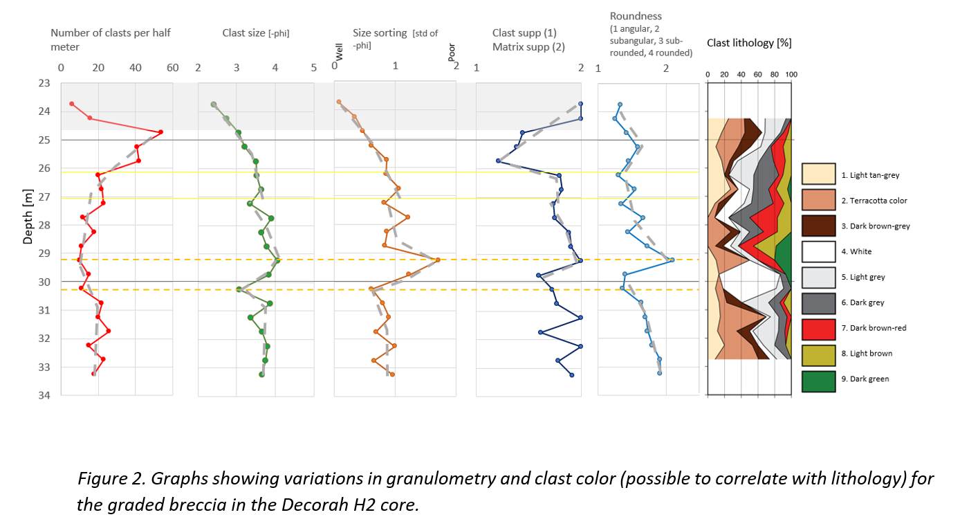
Methods: We log the polymict breccias of the 5cm in diameter H2 and CS1 cores as their observed grading [5] suggests resurge deposits [cf. 1]. At the time of writing, only H2 is fully logged and interpreted. CS1 will be presented at the conference. The logged section of H2 spans 9.6m from the bottom of the core until the clasts sizes become to small (<5mm) for the method, i.e., the line-logging technique previously used for Lockne, Tvären, Chesapeake Bay, Wetumpka, Flynn Creek, Chicxulub, and Rochechouart [cf 1;4;8;9;10;11]. For most of these craters it was possible to work directly on the cores, but here we have, similarly to the Chicxulub study [8], used digital core photos and the software JMicroVision 1.2.7. The core recovery in the logged intervals of H2 and CS1 was >98%. Size sorting calculates as the standard deviation of the clast size per length unit (here half a meter). Roundness is estimated with a grain shape comparator [cf. 12]. Matrix- or clast support of each clast is based on contact with adjacent clasts and plotted as a ratio per length unit. Alltogether, plotted values show relative variations indicating trends, not absolute values. In addition, clast colors and textures were noted to enable an association with the target stratigraphy [e.g., 4; 8]
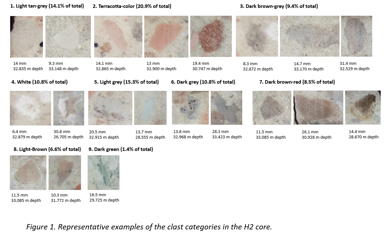
Results and discussion: A selection of the 416 clasts examined in H2 is shown in Fig 1. The plots in Fig. 2 support the normally graded appearance of the breccia as noted by [5]. When comparing with logs from aforementioned craters, where cores have reached through resurge deposits into underlying slump and avalance breccias, it is evident that H2 ends within resurge deposits. Nevertheless, the cored interval shows similar trends as several of the other craters. We primarily compare with Rochechouart. There, the sequence is subdivided into 6 intervals [see fig. 4 in 4]. Especially intervals 3–6 in Rochechouart show similarities to H2, whereas intervals 1-2 likely were not cored at Decorah, but would be expected as they represent the inevitable initial stages of the resurge. Intervals 3 and 4 at Rochechouart (“outwards passage of anti-resurge” followed by development of “body of standing water”) are characterized by slight upwards increase in clast frequency (until 32m in H2) followed by slight decrease (until 30.25m in H2). In the same interval at Rochechouart, the clast size and size sorting remained stable (up to 30.25m in H2), but accompanied by an increase in clast angularity (up to 30.25m in H2). With interval 5 at Rochechouart, a new pulse in transport energy caused a strong increase in clast size and drop in size sorting, as well as slight increase in roundness (29.25–30.25m in H2). This is then in Rochechouart followed by interval 6 that includes an increase in clast frequency and size sorting, and a generally normal grading towards the top (29.2m and upwards in H2). There is also a general upwards decrease in roundness similar to H2. This interval is interpreted to represent settling of material in a now almost water-filled crater, with seiches causing minor repeated beds (e.g., at 26m and 27m in H2)
H2 shows an obvious change in clast lithologies at interval 29.25–30.25m (Fig. 2). The “white” and“dark green” fragments are followed by “dark brown-red”, “dark grey” and “light brown”, whereas “terracotta colored”, “light tan-grey” and “light grey” appear throughout the logged sequence, possibly as the basement clasts do at Rochechouart.
Two stratigraphic intervals can be correlated with clast types; The Upper Cambrian Lone Rock Formation, which contains glauconitic and feldspathic sandstone with some beds of dolomite and green-gray shale, and the Lower Ordovician Oneota and Shakopee formations, which include beds that have been stained red owing to their relationship to the truncating, inter-regional unconformity at the base of directly overlying St. Peter Sandstone [6]. These two intervals produce the more easily traceable greenish and reddish clasts.
The calculated ‹N› = 43. The online "Earth impact effects program" calculator gives a 350m projectile diameter (d) for a final crater diameter of 5.8km. This results in 92m target water depth (H). This seems reasonable considering that resurge must have been able to overcome the elevated rim [cf. 1]. Likewise, certain benthic fossils in the Winneshiek Shale indicate a deposition within the photic zone (i.e., <200m) [cf. 13].


How to cite: Ormö, J., Sturkell, E., and King Jr., D. T.: Assessing target water depth and paleoenvironment at the Decorah impact structure, Iowa., Europlanet Science Congress 2024, Berlin, Germany, 8–13 Sep 2024, EPSC2024-48, https://doi.org/10.5194/epsc2024-48, 2024.